Current feed grain cultivation [Tajikistan]
- Creation:
- Update:
- Compiler: Malgorzata Conder
- Editor: –
- Reviewers: Fabian Ottiger, Alexandra Gavilano
technologies_1158 - Tajikistan
View sections
Expand all Collapse all1. General information
1.2 Contact details of resource persons and institutions involved in the assessment and documentation of the Technology
Name of the institution(s) which facilitated the documentation/ evaluation of the Technology (if relevant)
CDE Centre for Development and Environment (CDE Centre for Development and Environment) - Switzerland1.3 Conditions regarding the use of data documented through WOCAT
The compiler and key resource person(s) accept the conditions regarding the use of data documented through WOCAT:
Yes
2. Description of the SLM Technology
2.1 Short description of the Technology
Definition of the Technology:
Cultivation of wheat or feed grain for straw production on a degraded plot
2.2 Detailed description of the Technology
Description:
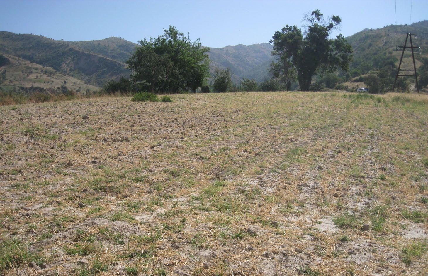
The farmer started to plant flax for oil production on his 0.2 hectare plot, which gave a good harvest. Since 1999 the farmer has cultivated wheat and feed grain, rotating year by year. According to the farmer, wheat and feed grain cropping does not provide a benefit on that plot, when money and labour inputs are considered. But as straw is scarce but is needed for his cows, the farmer gets that by-product from harvesting wheat. Furthermore, as that plot is accessible by the tractor for ploughing, he plants wheat and will continue doing that in future, even though the output is low. Though the farmer has a land user's certificate for that property, it becomes common for livestock grazing after the harvest. This causes overgrazing, bare soil, trampling and other issues.
Purpose of the Technology: The purpose of cropping wheat is to get straw for feeding. According to the farmer the bad quality of soil and the absence of water do not allow a different crop type than wheat.
Establishment / maintenance activities and inputs: Establishment and maintenance activities are almost the same. The crop must be ploughed, seeds planted and fertilizer applied. Though no fertilizer was needed at the beginning of crop cultivation, now its use is increasing. Between the time of planting and harvesting, the crop is regularly safe guarded from grazing livestock. If herds approach, the farmer or a family member will protect the crop. After the harvest, the crop is somehow declared as communal land, where cattle are allowed to graze there.
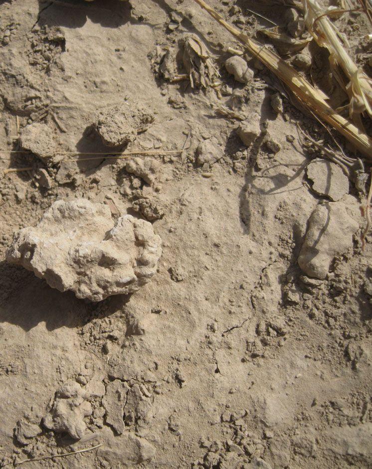
Natural / human environment: The crop is situated on a ridge above the village of Chargii bolo. It is a small sized terrace with a slight slope. Soil quality and moisture were already very poor when the crop was established, which results in a low output comparing to the input. The soil is compacted and shows a low level of organic matter, soil moisture and nutrients. The farmer complains about the small sharp stones of around 1-2 cm of diameter in the soil. They indicate a high level of soil degradation. Although the slope is slight, the vertical ploughing has caused small rills in the lower part of the plot and some more pronounced rills off-site. The plot is the property of the farmer, but is used as pasture after harvest for the livestock. Soil compaction, lowered vegetation cover and water infiltration result from trampling and overgrazing. There’s no agreement between cultivars and herders, reason why this crop continues to be grazed uncontrolled.
2.3 Photos of the Technology
Media Gallery
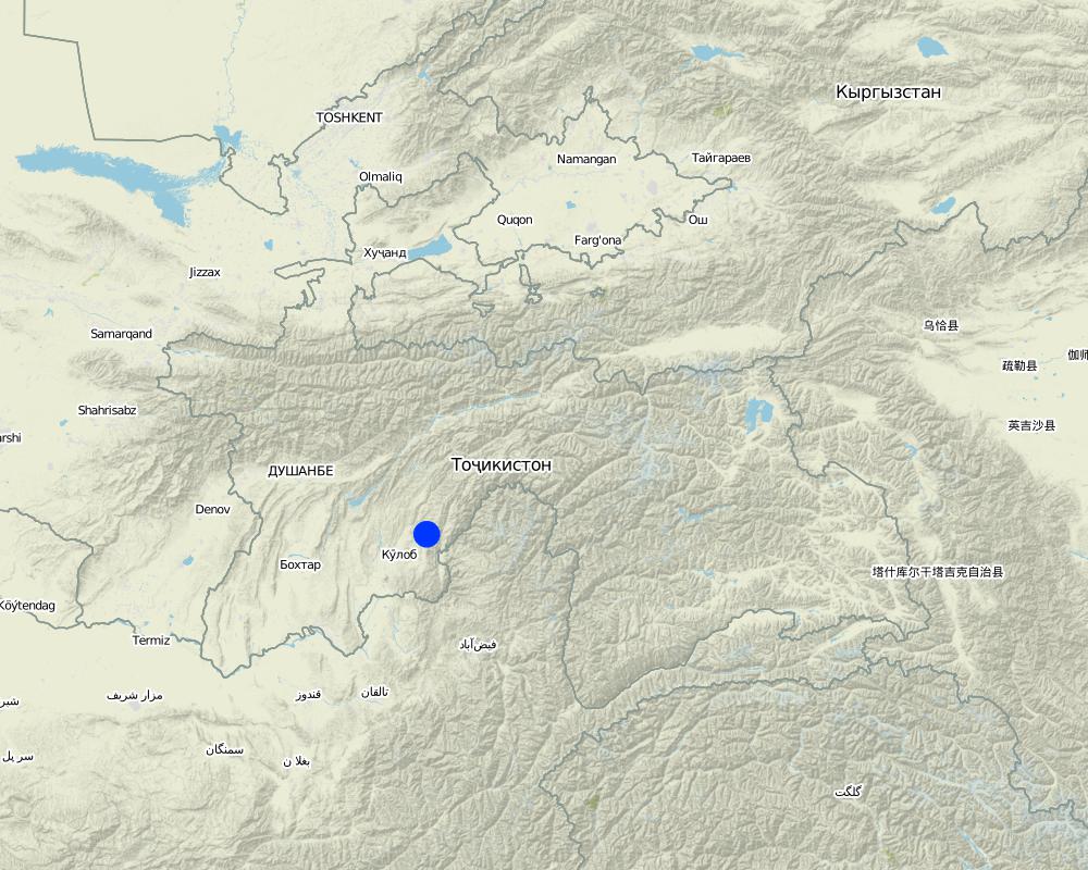
2.5 Country/ region/ locations where the Technology has been applied and which are covered by this assessment
Country:
Tajikistan
Region/ State/ Province:
Khatlon, Tajikistan
Further specification of location:
Muminobod
Specify the spread of the Technology:
- evenly spread over an area
If precise area is not known, indicate approximate area covered:
- < 0.1 km2 (10 ha)
Map
×2.6 Date of implementation
If precise year is not known, indicate approximate date:
- 10-50 years ago
2.7 Introduction of the Technology
Specify how the Technology was introduced:
- through land users' innovation
Comments (type of project, etc.):
Since 1999. Farmer claims that he only can cultivate wheat on that crop.
3. Classification of the SLM Technology
3.1 Main purpose(s) of the Technology
- improve production
- create beneficial economic impact
3.2 Current land use type(s) where the Technology is applied

Cropland
- Annual cropping
Annual cropping - Specify crops:
- fodder crops - grasses
- fodder crops - other
Number of growing seasons per year:
- 1
Specify:
Longest growing period in days: 180 Longest growing period from month to month: April-Sept/Oct
Comments:
Major land use problems (compiler’s opinion): Low soil nutrients and moisture on that plot. Bare and crusted soil which cause worse infiltration capacities and soil erosion. Building of small rills enhanced through vertical ploughing.
Additionally, overgrazing by livestock, compaction of soil.
Major land use problems (land users’ perception): Crop was already degraded at the beginning but its getting worse. Small and sharp stones which are in the soil indicate the compaction and low level of nutrients.
Livestock is grazing on crop residues
3.4 Water supply
Water supply for the land on which the Technology is applied:
- rainfed
3.5 SLM group to which the Technology belongs
- rotational systems (crop rotation, fallows, shifting cultivation)
- pastoralism and grazing land management
- Feed grain cultivation
3.7 Main types of land degradation addressed by the Technology

soil erosion by water
- Wt: loss of topsoil/ surface erosion
- Wo: offsite degradation effects

physical soil deterioration
- Pc: compaction

biological degradation
- Bc: reduction of vegetation cover
Comments:
Main type of degradation addressed: Pc: compaction, Bc: reduction of vegetation cover
Secondary types of degradation addressed: Wt: loss of topsoil / surface erosion, Wo: offsite degradation effects
Main causes of degradation: soil management (vertical plowing), land tenure (cropping and afterwards grazing)
Secondary causes of degradation: overgrazing
3.8 Prevention, reduction, or restoration of land degradation
Specify the goal of the Technology with regard to land degradation:
- restore/ rehabilitate severely degraded land
4. Technical specifications, implementation activities, inputs, and costs
4.1 Technical drawing of the Technology
Technical specifications (related to technical drawing):
Vertical tillage by tractor on the slightly inclined crop is about to build a small rill. The absence of vegetation and additional grazing causes soil crusting and formation of small sharp stones.
Location: Chargi bolo. Muminabad, Khatlon, Tajikistan
Agronomic measure: vertical tillage
Material/ species: one year feed grain, next year wheat
4.2 General information regarding the calculation of inputs and costs
other/ national currency (specify):
Somoni
If relevant, indicate exchange rate from USD to local currency (e.g. 1 USD = 79.9 Brazilian Real): 1 USD =:
4.83
Indicate average wage cost of hired labour per day:
12.40
4.5 Maintenance/ recurrent activities
| Activity | Timing/ frequency | |
|---|---|---|
| 1. | Plowing, 11 hours, 1 person | spring (7.April)/ once a year |
| 2. | Sowing wheat, 10-12 hours, 3 persons | spring (7.April)/once a year |
| 3. | Applying fertilizer, 10 hours, 1 person | spring (20.Mai)/ once a year |
| 4. | Cutting wheat, 4-5 days, 3 persons | autumn/ once a year |
| 5. | Guarding, 1 person | unregularly - sporadically |
4.6 Costs and inputs needed for maintenance/ recurrent activities (per year)
| Specify input | Unit | Quantity | Costs per Unit | Total costs per input | % of costs borne by land users | |
|---|---|---|---|---|---|---|
| Labour | Plowing | Person days | 1.4 | 12.214 | 17.1 | 100.0 |
| Labour | Sowing wheat | Person days | 4.125 | 12.412 | 51.2 | 100.0 |
| Labour | Applying fertilizer | Person days | 1.4 | 12.214 | 17.1 | 100.0 |
| Labour | Cutting wheat | Person days | 13.5 | 12.422 | 167.7 | 100.0 |
| Equipment | Petrol | liters | 14.0 | 1.14 | 15.96 | 100.0 |
| Equipment | Machine use | hours | 2.0 | 2.6 | 5.2 | 100.0 |
| Plant material | Seeds | 12.4 | 100.0 | |||
| Fertilizers and biocides | Fertilizer | kg | 12.0 | 0.755 | 9.06 | 100.0 |
| Other | Guarding | |||||
| Total costs for maintenance of the Technology | 283.32 | |||||
| Total costs for maintenance of the Technology in USD | 58.66 | |||||
Comments:
Labour, machine use and petrol was indicated for totally 0.8 ha, this is why all input is divided by 4 for the compilation of reccurent activities for the plot of 0.2 ha. The input were further multiplied by factor 5 for the cost overview for one ha.
4.7 Most important factors affecting the costs
Describe the most determinate factors affecting the costs:
Agricultural inputs as seeds and fertilizer are the most expensive
5. Natural and human environment
5.1 Climate
Annual rainfall
- < 250 mm
- 251-500 mm
- 501-750 mm
- 751-1,000 mm
- 1,001-1,500 mm
- 1,501-2,000 mm
- 2,001-3,000 mm
- 3,001-4,000 mm
- > 4,000 mm
Specifications/ comments on rainfall:
Totally 800 mm: 700mm in winter-spring, July-Sept dry season
Agro-climatic zone
- sub-humid
Thermal climate class: temperate
5.2 Topography
Slopes on average:
- flat (0-2%)
- gentle (3-5%)
- moderate (6-10%)
- rolling (11-15%)
- hilly (16-30%)
- steep (31-60%)
- very steep (>60%)
Landforms:
- plateau/plains
- ridges
- mountain slopes
- hill slopes
- footslopes
- valley floors
Altitudinal zone:
- 0-100 m a.s.l.
- 101-500 m a.s.l.
- 501-1,000 m a.s.l.
- 1,001-1,500 m a.s.l.
- 1,501-2,000 m a.s.l.
- 2,001-2,500 m a.s.l.
- 2,501-3,000 m a.s.l.
- 3,001-4,000 m a.s.l.
- > 4,000 m a.s.l.
Comments and further specifications on topography:
Slopes on average: Moderate (ranked 1) and rolling (ranked 2, up to 11%)
5.3 Soils
Soil depth on average:
- very shallow (0-20 cm)
- shallow (21-50 cm)
- moderately deep (51-80 cm)
- deep (81-120 cm)
- very deep (> 120 cm)
Soil texture (topsoil):
- medium (loamy, silty)
- fine/ heavy (clay)
If available, attach full soil description or specify the available information, e.g. soil type, soil PH/ acidity, Cation Exchange Capacity, nitrogen, salinity etc.
Soil fertility: High
Soil drainage/infiltration: Poor (presence of "compacted stones" of 1-2 cm in the soil)
Soil water storage capacity: Very low
5.4 Water availability and quality
Availability of surface water:
poor/ none
Water quality (untreated):
for agricultural use only (irrigation)
5.5 Biodiversity
Species diversity:
- low
5.6 Characteristics of land users applying the Technology
Market orientation of production system:
- subsistence (self-supply)
Off-farm income:
- less than 10% of all income
Relative level of wealth:
- average
Level of mechanization:
- manual work
- mechanized/ motorized
Indicate other relevant characteristics of the land users:
Population density: 100-200 persons/km2
Annual population growth: 1% - 2%
Level of mechanization: Mechanised (Ploughing and cutting fodder grain, ranked 1) and manual labour (sowing and putting fertilizer, ranked 2)
5.7 Average area of land used by land users applying the Technology
- < 0.5 ha
- 0.5-1 ha
- 1-2 ha
- 2-5 ha
- 5-15 ha
- 15-50 ha
- 50-100 ha
- 100-500 ha
- 500-1,000 ha
- 1,000-10,000 ha
- > 10,000 ha
5.8 Land ownership, land use rights, and water use rights
Land ownership:
- individual, titled
Land use rights:
- leased
Water use rights:
- communal (organized)
5.9 Access to services and infrastructure
health:
- poor
- moderate
- good
education:
- poor
- moderate
- good
technical assistance:
- poor
- moderate
- good
employment (e.g. off-farm):
- poor
- moderate
- good
markets:
- poor
- moderate
- good
energy:
- poor
- moderate
- good
roads and transport:
- poor
- moderate
- good
drinking water and sanitation:
- poor
- moderate
- good
financial services:
- poor
- moderate
- good
6. Impacts and concluding statements
6.1 On-site impacts the Technology has shown
Socio-economic impacts
Production
crop production
Income and costs
expenses on agricultural inputs
workload
Comments/ specify:
less/ no guardening
Socio-cultural impacts
food security/ self-sufficiency
Ecological impacts
Water cycle/ runoff
water quantity
surface runoff
evaporation
Soil
soil moisture
soil cover
soil crusting/ sealing
soil compaction
soil organic matter/ below ground C
6.2 Off-site impacts the Technology has shown
buffering/ filtering capacity
damage on neighbours' fields
6.3 Exposure and sensitivity of the Technology to gradual climate change and climate-related extremes/ disasters (as perceived by land users)
Gradual climate change
Gradual climate change
| Season | increase or decrease | How does the Technology cope with it? | |
|---|---|---|---|
| annual temperature | increase | not well |
Climate-related extremes (disasters)
Meteorological disasters
| How does the Technology cope with it? | |
|---|---|
| local rainstorm | not well |
| local windstorm | not known |
Climatological disasters
| How does the Technology cope with it? | |
|---|---|
| drought | not well |
Hydrological disasters
| How does the Technology cope with it? | |
|---|---|
| general (river) flood | not well |
Other climate-related consequences
Other climate-related consequences
| How does the Technology cope with it? | |
|---|---|
| reduced growing period | not known |
6.7 Strengths/ advantages/ opportunities of the Technology
| Strengths/ advantages/ opportunities in the land user’s view |
|---|
| Suitable cropland for wheat production as it is accessible by tractor and shows a small inclination. |
6.8 Weaknesses/ disadvantages/ risks of the Technology and ways of overcoming them
| Weaknesses/ disadvantages/ risks in the compiler’s or other key resource person’s view | How can they be overcome? |
|---|---|
| Soil erosion, high run off rate, low infiltration capacity, low soil moisture. |
Countour tillage, crop rotation, double digging or breaking of compacted subsoil. Knowledge transfer for showing alternatives to wheat and fodder grain cropping (crop rotation). |
| Uncontrolled grazing after the harvest reduces vegetation cover to hardly no cover, which makes soil very exposed to soil erosion etc. | Regulate and coordinate grazing. |
7. References and links
7.1 Methods/ sources of information
Links and modules
Expand all Collapse allLinks
No links
Modules
No modules