Artificial Grassed Waterway [Kenya]
- Creation:
- Update:
- Compiler: Paul Kahiga
- Editor: –
- Reviewers: Fabian Ottiger, Alexandra Gavilano
Grassed waterways
technologies_1320 - Kenya
View sections
Expand all Collapse all1. General information
1.2 Contact details of resource persons and institutions involved in the assessment and documentation of the Technology
SLM specialist:
Chege Timothy
Jomo Kenyatta University of Agriculture and Technology
Kenya
SLM specialist:
Gathenya Mwangi
Jomo Kenyatta University of Agriculture and Technology
Kenya
SLM specialist:
Home Patrick
Jomo Kenyatta University of Agriculture and Technology
Kenya
SLM specialist:
Wamuongo Jane
Kenya Agricultural Research Institute
Kenya
SLM specialist:
Karanja Andrew
Kenya Agricultural Research Institute
Kenya
Name of the institution(s) which facilitated the documentation/ evaluation of the Technology (if relevant)
KARI Headquarters (KARI Headquarters) - KenyaName of the institution(s) which facilitated the documentation/ evaluation of the Technology (if relevant)
Jomo Kenyatta University (Jomo Kenyatta University) - Kenya1.3 Conditions regarding the use of data documented through WOCAT
The compiler and key resource person(s) accept the conditions regarding the use of data documented through WOCAT:
Yes
1.4 Declaration on sustainability of the described Technology
Is the Technology described here problematic with regard to land degradation, so that it cannot be declared a sustainable land management technology?
No
2. Description of the SLM Technology
2.1 Short description of the Technology
Definition of the Technology:
Artificial grassed waterways are constructed waterways established for transportation of concentrated flow at safe velocities using adequate vegetation.
2.2 Detailed description of the Technology
Description:
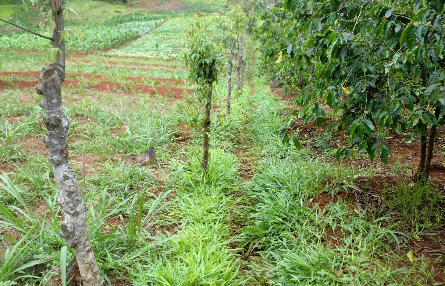
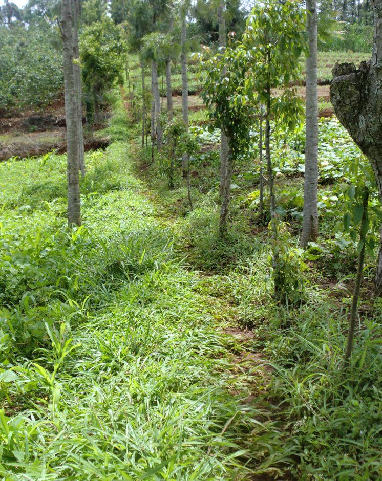
Grassed waterways are natural or constructed channels established for transport of concentrated flow at safe velocities using adequate vegetation. They are generally broad and shallow by design to move surface water across farms without causing soil erosion. The vegetative cover slows the water flow, minimizing channel surface erosion. When properly constructed, grassed waterways can safely transport large water flows down slope. These waterways can also be used as outlets for water released from contoured and terraced systems and from diverted channels. This practice reduces sedimentation of nearby water bodies and pollutants in runoff.
Purpose of the Technology: In Embu District, waterways are constructed to act both as a channel of disposing run-off into the river and a foot path. The type of vegetation that is used in this district is fodder grass called paspalum. They are used on slopes of less than 20% and where flow velocities do not exceed 1.8 m/s. They are also suitable in areas where rainfall intensities are high and excess run-off is frequent, such as slopes in humid regions, in semi-arid or arid regions where soil infiltration rates are low and run-off is concentrated, where cultivated fields have been treated with various types of terracing systems and drainage is necessary and on non-cultivated lands to connect run-off drainage structures such as diversions, cut-off ditches. Advantages of grassed waterways include flood damage prevention; erosion control; aesthetic value; water quality improvement; design based on landowner’s/farmer’s experience; soluble contaminant flow retardation; and dispersion of concentrated flow, thereby minimizing gully erosion.
Establishment / maintenance activities and inputs: Limitations of this practice include the cost of installation (e.g., grading slopes and vegetation establishment), loss of acreage for pasture or crops and the variability of effectiveness due to the uncertainty of runoff rate and frequency. Disadvantages of a grassed waterway include working around it with farm equipment, vegetative growth may be troublesome and the depth of the waterway limits it as a tile drainage outlet. The construction of the waterway will depend on the soil’s erosive potential. For example, a shallower waterway will result in an area with more erodible soil. Depending on the equipment and labor costs, grading, seed and fertilizer selected, the cost of establishing grassed waterways will vary. However in most cases where no additional structures are constructed on the waterway, grassed waterways are cheap to construct. Potential returns include fodder for feeding the farmers animals which is very common in Embu North District.
2.3 Photos of the Technology
Media Gallery
2.5 Country/ region/ locations where the Technology has been applied and which are covered by this assessment
Country:
Kenya
Region/ State/ Province:
Eastern Province
Further specification of location:
Embu North District
Specify the spread of the Technology:
- evenly spread over an area
If precise area is not known, indicate approximate area covered:
- 1-10 km2
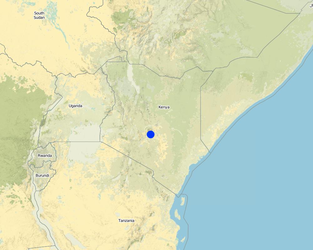
Map
×2.7 Introduction of the Technology
Specify how the Technology was introduced:
- during experiments/ research
3. Classification of the SLM Technology
3.1 Main purpose(s) of the Technology
- improve production
- reduce, prevent, restore land degradation
- create beneficial economic impact
3.2 Current land use type(s) where the Technology is applied

Cropland
- Annual cropping
- Tree and shrub cropping
Annual cropping - Specify crops:
- cereals - maize
- fodder crops - grasses
- vegetables - leafy vegetables (salads, cabbage, spinach, other)
- coffee
Number of growing seasons per year:
- 1
Specify:
Longest growing period in days: 90, Longest growing period from month to month: May to July
Comments:
Major land use problems (compiler’s opinion): Soil erosion on water ways
Major land use problems (land users’ perception): Soil erosion from the runoff
3.4 Water supply
Water supply for the land on which the Technology is applied:
- rainfed
3.5 SLM group to which the Technology belongs
- irrigation management (incl. water supply, drainage)
- water diversion and drainage
- surface water management (spring, river, lakes, sea)
3.6 SLM measures comprising the Technology

agronomic measures
- A1: Vegetation/ soil cover
- A3: Soil surface treatment
A3: Differentiate tillage systems:
A 3.1: No tillage
Comments:
Type of agronomic measures: better crop cover, zero tillage / no-till
3.7 Main types of land degradation addressed by the Technology

soil erosion by water
- Wt: loss of topsoil/ surface erosion
Comments:
Main causes of degradation: soil management
3.8 Prevention, reduction, or restoration of land degradation
Specify the goal of the Technology with regard to land degradation:
- prevent land degradation
4. Technical specifications, implementation activities, inputs, and costs
4.1 Technical drawing of the Technology
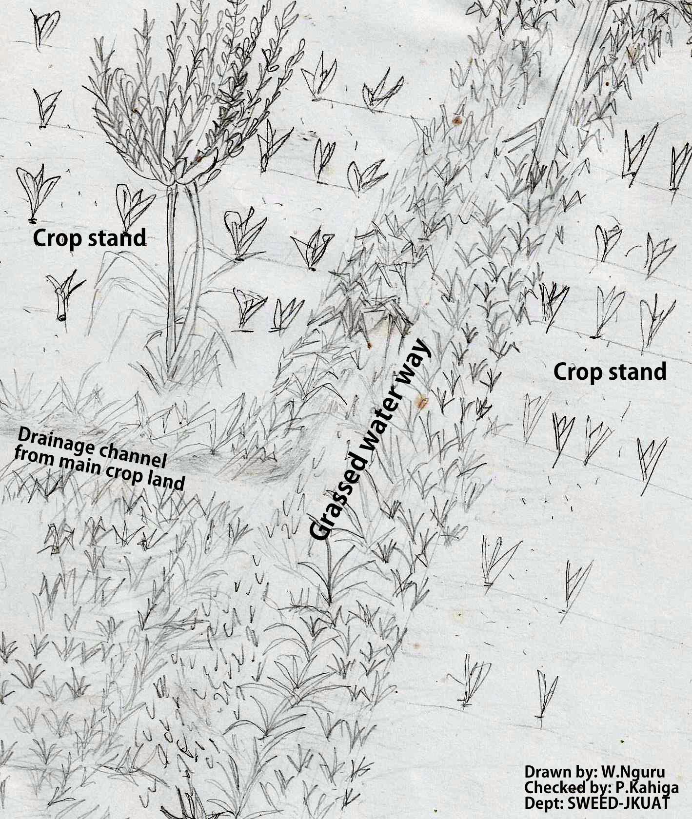
Technical specifications (related to technical drawing):
The technical drawing on the left shows a typical artificial grassed water way. Farmers plant grass along a pathway that acts as a both foot path and waterway to drain runoff from the main crop land along a drainage channel. Some times it is constructed along a boundary between to farms. As water flows down the slope through the grassed water way, the soil particles are filtered by the grass.
Location: Embu North District. Eastern
Date: 02/09/2011
Technical knowledge required for field staff / advisors: low
Technical knowledge required for land users: moderate
Main technical functions: improvement of ground cover
Secondary technical functions: increase of surface roughness
Better crop cover
Material/ species: Fodder grass
Quantity/ density: t/ha
Remarks: scattered
Zero tillage / no-till
Material/ species: Planting hole is made only where the grass is planted
Author:
Paul Kahiga, 62000-00200, Nairobi
4.2 General information regarding the calculation of inputs and costs
other/ national currency (specify):
Kshs
If relevant, indicate exchange rate from USD to local currency (e.g. 1 USD = 79.9 Brazilian Real): 1 USD =:
100.0
Indicate average wage cost of hired labour per day:
2.50
4.3 Establishment activities
| Activity | Timing (season) | |
|---|---|---|
| 1. | Purchase of gras seeds |
4.4 Costs and inputs needed for establishment
| Specify input | Unit | Quantity | Costs per Unit | Total costs per input | % of costs borne by land users | |
|---|---|---|---|---|---|---|
| Labour | Planting grass | ha | 1.0 | 10.0 | 10.0 | 100.0 |
| Equipment | Tools | ha | 1.0 | 20.0 | 20.0 | 100.0 |
| Plant material | Grass seeds | ha | 1.0 | 25.0 | 25.0 | 100.0 |
| Total costs for establishment of the Technology | 55.0 | |||||
| Total costs for establishment of the Technology in USD | 0.55 | |||||
Comments:
Life span of the product (grass): 1 year
4.5 Maintenance/ recurrent activities
| Activity | Timing/ frequency | |
|---|---|---|
| 1. | Reseeding | 1 |
| 2. | Replanting of grass vines | 1 |
4.6 Costs and inputs needed for maintenance/ recurrent activities (per year)
| Specify input | Unit | Quantity | Costs per Unit | Total costs per input | % of costs borne by land users | |
|---|---|---|---|---|---|---|
| Labour | Reseeding | 10m | 1.0 | 2.5 | 2.5 | 100.0 |
| Labour | Replanting of grass vines | 500, | 1.0 | 2.5 | 2.5 | 100.0 |
| Total costs for maintenance of the Technology | 5.0 | |||||
| Total costs for maintenance of the Technology in USD | 0.05 | |||||
Comments:
Machinery/ tools: Jembes and pangas
4.7 Most important factors affecting the costs
Describe the most determinate factors affecting the costs:
costs of grass seeds or plantings and labour during planting
5. Natural and human environment
5.1 Climate
Annual rainfall
- < 250 mm
- 251-500 mm
- 501-750 mm
- 751-1,000 mm
- 1,001-1,500 mm
- 1,501-2,000 mm
- 2,001-3,000 mm
- 3,001-4,000 mm
- > 4,000 mm
Agro-climatic zone
- sub-humid
Thermal climate class: tropics
5.2 Topography
Slopes on average:
- flat (0-2%)
- gentle (3-5%)
- moderate (6-10%)
- rolling (11-15%)
- hilly (16-30%)
- steep (31-60%)
- very steep (>60%)
Landforms:
- plateau/plains
- ridges
- mountain slopes
- hill slopes
- footslopes
- valley floors
Altitudinal zone:
- 0-100 m a.s.l.
- 101-500 m a.s.l.
- 501-1,000 m a.s.l.
- 1,001-1,500 m a.s.l.
- 1,501-2,000 m a.s.l.
- 2,001-2,500 m a.s.l.
- 2,501-3,000 m a.s.l.
- 3,001-4,000 m a.s.l.
- > 4,000 m a.s.l.
5.3 Soils
Soil depth on average:
- very shallow (0-20 cm)
- shallow (21-50 cm)
- moderately deep (51-80 cm)
- deep (81-120 cm)
- very deep (> 120 cm)
Soil texture (topsoil):
- medium (loamy, silty)
Topsoil organic matter:
- medium (1-3%)
If available, attach full soil description or specify the available information, e.g. soil type, soil PH/ acidity, Cation Exchange Capacity, nitrogen, salinity etc.
Soil fertility: Medium
Soil drainage/infiltration: Good
Soil water storage capacity: Low
5.4 Water availability and quality
Ground water table:
5-50 m
Availability of surface water:
good
Water quality (untreated):
good drinking water
5.5 Biodiversity
Species diversity:
- medium
5.6 Characteristics of land users applying the Technology
Market orientation of production system:
- mixed (subsistence/ commercial)
Off-farm income:
- less than 10% of all income
Relative level of wealth:
- average
Individuals or groups:
- individual/ household
Level of mechanization:
- manual work
Gender:
- women
- men
Indicate other relevant characteristics of the land users:
Land users applying the Technology are mainly common / average land users
Population density: 10-50 persons/km2
Annual population growth: 0.5% - 1%
70% of the land users are average wealthy and own 100% of the land.
5.7 Average area of land used by land users applying the Technology
- < 0.5 ha
- 0.5-1 ha
- 1-2 ha
- 2-5 ha
- 5-15 ha
- 15-50 ha
- 50-100 ha
- 100-500 ha
- 500-1,000 ha
- 1,000-10,000 ha
- > 10,000 ha
Is this considered small-, medium- or large-scale (referring to local context)?
- small-scale
5.8 Land ownership, land use rights, and water use rights
Land ownership:
- individual, titled
Land use rights:
- individual
Water use rights:
- individual
5.9 Access to services and infrastructure
health:
- poor
- moderate
- good
education:
- poor
- moderate
- good
6. Impacts and concluding statements
6.1 On-site impacts the Technology has shown
Socio-economic impacts
Production
fodder production
animal production
land management
Income and costs
farm income
Socio-cultural impacts
food security/ self-sufficiency
SLM/ land degradation knowledge
Improved livelihoods and human well-being
Comments/ specify:
Fodder grass, pathways and acts as boundaries
Ecological impacts
Water cycle/ runoff
water quality
surface runoff
excess water drainage
Biodiversity: vegetation, animals
pest/ disease control
Comments/ specify:
Depends on the type of grass
6.2 Off-site impacts the Technology has shown
downstream siltation
buffering/ filtering capacity
6.3 Exposure and sensitivity of the Technology to gradual climate change and climate-related extremes/ disasters (as perceived by land users)
Climate-related extremes (disasters)
Meteorological disasters
| How does the Technology cope with it? | |
|---|---|
| local rainstorm | well |
| local windstorm | well |
6.4 Cost-benefit analysis
How do the benefits compare with the establishment costs (from land users’ perspective)?
Short-term returns:
positive
Long-term returns:
positive
How do the benefits compare with the maintenance/ recurrent costs (from land users' perspective)?
Short-term returns:
positive
Long-term returns:
positive
6.5 Adoption of the Technology
Of all those who have adopted the Technology, how many did so spontaneously, i.e. without receiving any material incentives/ payments?
- 91-100%
Comments:
100% of land user families have adopted the Technology without any external material support
Comments on spontaneous adoption: They do it on their own
There is a moderate trend towards spontaneous adoption of the Technology
6.7 Strengths/ advantages/ opportunities of the Technology
| Strengths/ advantages/ opportunities in the compiler’s or other key resource person’s view |
|---|
| In the artificial grassed water ways, the grass used is also used as a fodder grass. |
| The grass prevents soil erosion on the drainage channels. |
| Once the grass have been established, maintenance cost is relatively low. |
6.8 Weaknesses/ disadvantages/ risks of the Technology and ways of overcoming them
| Weaknesses/ disadvantages/ risks in the compiler’s or other key resource person’s view | How can they be overcome? |
|---|---|
| Paspalum grass roots are favorite for moles which eat up other crops. | Use of grass or vegetation that is not favorite for moles |
| Sometimes, waterways may abstract passage of farm machinery | Avoid crossing the waterway with heavy machinery when the soils are wet. |
7. References and links
7.1 Methods/ sources of information
- field visits, field surveys
- interviews with land users
When were the data compiled (in the field)?
08/02/2011
Links and modules
Expand all Collapse allLinks
No links
Modules
No modules