Strengthening of river banks with stones and gabions [Tajikistan]
- Creation:
- Update:
- Compiler: German Kust
- Editor: –
- Reviewers: Olga Andreeva, Joana Eichenberger
Strengthening of the river banks with stones and gabions (English)
technologies_1362 - Tajikistan
- Full summary as PDF
- Full summary as PDF for print
- Full summary in the browser
- Full summary (unformatted)
- Strengthening of river banks with stones and gabions: March 21, 2017 (inactive)
- Strengthening of river banks with stones and gabions: July 31, 2017 (inactive)
- Strengthening of river banks with stones and gabions: Feb. 14, 2020 (inactive)
- Strengthening of river banks with stones and gabions: Nov. 2, 2021 (public)
View sections
Expand all Collapse all1. General information
1.2 Contact details of resource persons and institutions involved in the assessment and documentation of the Technology
SLM specialist:
Rustam Rakhimov
Community Agriculture and Watershed Management project in Tajikistan
Tajikistan
Name of project which facilitated the documentation/ evaluation of the Technology (if relevant)
Community Agriculture and Watershed Management project in Tajikistan (WB / CAWMP)Name of project which facilitated the documentation/ evaluation of the Technology (if relevant)
Pilot Program for Climate Resilience, Tajikistan (WB / PPCR)1.3 Conditions regarding the use of data documented through WOCAT
The compiler and key resource person(s) accept the conditions regarding the use of data documented through WOCAT:
Yes
1.4 Declaration on sustainability of the described Technology
Is the Technology described here problematic with regard to land degradation, so that it cannot be declared a sustainable land management technology?
No
2. Description of the SLM Technology
2.1 Short description of the Technology
Definition of the Technology:
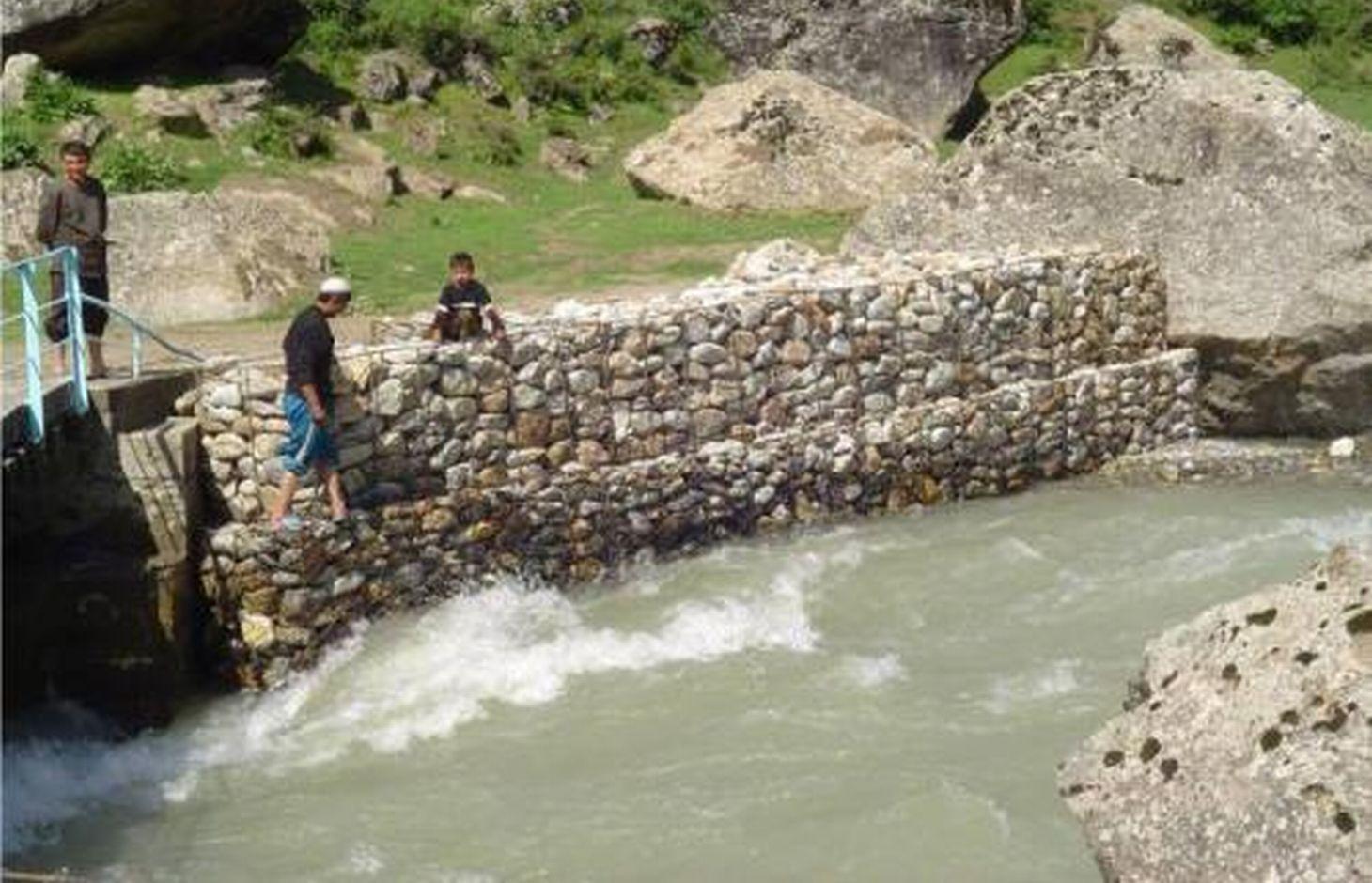
Strengthening of river banks and counter landslide operations with the use of stones and gabions
2.2 Detailed description of the Technology
Description:
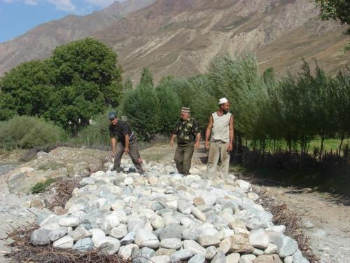
The technology includes collection of stones of average size (with the diameter of 20-40cm) and laying them in a specific way in places that are most affected by the water flow and which are prone to washout. Stones will protect arable and inhabited areas from washouts. There are two traditional ways for laying stones: (1) in the form of gabions or, in other words, stones are laid in the form of vertical walls bounded with wire, (2) in the form of masonry when stones are laid on branches of trees and shrubs.
Purpose of the Technology: Preventing river banks from being washed out by water flow and mudslides.
Establishment / maintenance activities and inputs: Collection of stones and tree branches, laying them down in a specific way, tying stones with tree branches or wire.
Natural / human environment: The technology is applicable to any river banks in rural settlements.
2.3 Photos of the Technology
Media Gallery
2.5 Country/ region/ locations where the Technology has been applied and which are covered by this assessment
Country:
Tajikistan
Region/ State/ Province:
Tajikistan
Further specification of location:
Tajikobod region, Jamoats of Shirinchashma and Shagodaev
Specify the spread of the Technology:
- evenly spread over an area
If precise area is not known, indicate approximate area covered:
- 1-10 km2
Is/are the technology site(s) located in a permanently protected area?
No
Comments:
A total of 6 subprojects on strengthening of river banks have been implemented in the frameworks of the World Bank’s CAWMP project. This data basically refers to the Tajikobod region
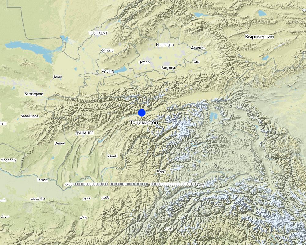
Map
×2.6 Date of implementation
If precise year is not known, indicate approximate date:
- more than 50 years ago (traditional)
2.7 Introduction of the Technology
Specify how the Technology was introduced:
- as part of a traditional system (> 50 years)
3. Classification of the SLM Technology
3.1 Main purpose(s) of the Technology
- reduce, prevent, restore land degradation
- protect a watershed/ downstream areas – in combination with other Technologies
- reduce risk of disasters
3.2 Current land use type(s) where the Technology is applied
Land use mixed within the same land unit:
Yes
Specify mixed land use (crops/ grazing/ trees):
- Silvo-pastoralism

Cropland
- Annual cropping
Number of growing seasons per year:
- 1
Is intercropping practiced?
No

Grazing land
Extensive grazing:
- Ranching
Animal type:
- sheep

Forest/ woodlands
- (Semi-)natural forests/ woodlands
Comments:
Major land use problems (compiler’s opinion): Washout of river banks by water and mudslides, reduction of arable land,
Major land use problems (land users’ perception): Washout of river banks by water and mudslides, reduction of arable land
Mixed: (eg agro-pastoralism, silvo-pastoralism): Yes
Future (final) land use (after implementation of SLM Technology): Other: Os: Settlements, infrastructure networks
Livestock is grazing on crop residues
Constraints of settlement / urban: Risk of washouts
3.3 Has land use changed due to the implementation of the Technology?
Grazing land

Settlements, infrastructure
Comments:
Other: Os: Settlements, infrastructure networks
3.4 Water supply
Water supply for the land on which the Technology is applied:
- mixed rainfed-irrigated
Comments:
Водопотребление: смешанное богарно-орошаемое
3.5 SLM group to which the Technology belongs
- cross-slope measure
- surface water management (spring, river, lakes, sea)
3.6 SLM measures comprising the Technology

vegetative measures
- V1: Tree and shrub cover

structural measures
- S5: Dams, pans, ponds
- S6: Walls, barriers, palisades, fences

management measures
- M3: Layout according to natural and human environment
Comments:
Main measures: structural measures
Secondary measures: vegetative measures, management measures
Type of vegetative measures: aligned: -linear, in blocks
3.7 Main types of land degradation addressed by the Technology

soil erosion by water
- Wm: mass movements/ landslides
- Wr: riverbank erosion
Comments:
Main type of degradation addressed: Wr: riverbank erosion
Main causes of degradation: Heavy / extreme rainfall (intensity/amounts), floods
Secondary causes of degradation: over-exploitation of vegetation for domestic use, other natural causes (avalanches, volcanic eruptions, mud flows, highly susceptible natural resources, extreme topography, etc.) specify
3.8 Prevention, reduction, or restoration of land degradation
Specify the goal of the Technology with regard to land degradation:
- prevent land degradation
Comments:
Secondary goals: mitigation / reduction of land degradation, rehabilitation / reclamation of denuded land
4. Technical specifications, implementation activities, inputs, and costs
4.1 Technical drawing of the Technology
Technical specifications (related to technical drawing):
Technical knowledge required for field staff / advisors: moderate (Must have engineering education (hydrotechnical))
Technical knowledge required for land users: moderate (Must be experienced in setting up such kind of structures)
Main technical functions: stabilisation of soil (eg by tree roots against land slides)
Secondary technical functions: control of concentrated runoff: impede / retard, control of concentrated runoff: drain / divert
Aligned: -linear
Vegetative material: T : trees / shrubs
In blocks
Vegetative material: T : trees / shrubs
Trees/ shrubs species: Trees and shrubs are planted after installation of gabions
Wall/ barrier
Height of bunds/banks/others (m): 1-3
Width of bunds/banks/others (m): 0,5-5
Length of bunds/banks/others (m): 5-20
Construction material (earth): When laying down stones on branches of trees, spaces between branches are filled with sediments
Construction material (stone): main material that withstands water flows and mudslides
Construction material (wood): Branches of trees are used to tie stones together and to create mats
Construction material (other): Metal wire is used to bind stones
Vegetation is used for stabilisation of structures.
Change of land use practices / intensity level: Previously dangerous areas are now successfully used
Layout change according to natural and human environment: Preserving previously dangerous areas
4.3 Establishment activities
| Activity | Timing (season) | |
|---|---|---|
| 1. | Collection of cuttings | Весна |
| 2. | Cuttings of poplar and willow trees or sea-buckthorn | Весна |
| 3. | Planting the cuttings | Весна |
| 4. | Collection and transportation of stones | Весна-Лето-Осень |
| 5. | Collection and transportation of branches of trees | Весна-Лето-Осень |
| 6. | Layout of mats or stones | Весна-Лето-Осень |
| 7. | Fixing stones in gabions | Весна-Лето-Осень |
| 8. | Design of structures | в течение года |
| 9. | Organization of works | в течение года |
4.5 Maintenance/ recurrent activities
| Activity | Timing/ frequency | |
|---|---|---|
| 1. | Replacement of destroyed sections of stones | Весна-Лето-Осень |
| 2. | Planting the cuttings | Весна |
| 3. | Maintenance of structures | в течение года |
| 4. | Repair works | в течение года |
4.6 Costs and inputs needed for maintenance/ recurrent activities (per year)
Comments:
$200-$800 USD costs are calculated for 1 running meter of the average structure with the use of manual labor
4.7 Most important factors affecting the costs
Describe the most determinate factors affecting the costs:
Season, distance of transportation of stones, height of the structure, width and thickness of the structure, opportunity to mechanise works
5. Natural and human environment
5.1 Climate
Annual rainfall
- < 250 mm
- 251-500 mm
- 501-750 mm
- 751-1,000 mm
- 1,001-1,500 mm
- 1,501-2,000 mm
- 2,001-3,000 mm
- 3,001-4,000 mm
- > 4,000 mm
Agro-climatic zone
- sub-humid
- semi-arid
Thermal climate class: temperate
5.2 Topography
Slopes on average:
- flat (0-2%)
- gentle (3-5%)
- moderate (6-10%)
- rolling (11-15%)
- hilly (16-30%)
- steep (31-60%)
- very steep (>60%)
Landforms:
- plateau/plains
- ridges
- mountain slopes
- hill slopes
- footslopes
- valley floors
Altitudinal zone:
- 0-100 m a.s.l.
- 101-500 m a.s.l.
- 501-1,000 m a.s.l.
- 1,001-1,500 m a.s.l.
- 1,501-2,000 m a.s.l.
- 2,001-2,500 m a.s.l.
- 2,501-3,000 m a.s.l.
- 3,001-4,000 m a.s.l.
- > 4,000 m a.s.l.
Comments and further specifications on topography:
Slopes on average: Also gentle
5.3 Soils
Soil depth on average:
- very shallow (0-20 cm)
- shallow (21-50 cm)
- moderately deep (51-80 cm)
- deep (81-120 cm)
- very deep (> 120 cm)
Soil texture (topsoil):
- coarse/ light (sandy)
Soil texture (> 20 cm below surface):
- medium (loamy, silty)
Topsoil organic matter:
- low (<1%)
5.4 Water availability and quality
Ground water table:
5-50 m
Availability of surface water:
excess
Water quality (untreated):
good drinking water
Water quality refers to:
surface water
Is water salinity a problem?
No
Is flooding of the area occurring?
Yes
Regularity:
episodically
5.5 Biodiversity
Species diversity:
- medium
Habitat diversity:
- medium
5.6 Characteristics of land users applying the Technology
Sedentary or nomadic:
- Sedentary
Market orientation of production system:
- mixed (subsistence/ commercial)
Off-farm income:
- > 50% of all income
Relative level of wealth:
- poor
Individuals or groups:
- groups/ community
Level of mechanization:
- manual work
- mechanized/ motorized
Gender:
- women
- men
Age of land users:
- youth
- middle-aged
- elderly
Indicate other relevant characteristics of the land users:
Land users applying the Technology are mainly common / average land users
Population density: 50-100 persons/km2
Annual population growth: 2% - 3%
5.7 Average area of land used by land users applying the Technology
- < 0.5 ha
- 0.5-1 ha
- 1-2 ha
- 2-5 ha
- 5-15 ha
- 15-50 ha
- 50-100 ha
- 100-500 ha
- 500-1,000 ha
- 1,000-10,000 ha
- > 10,000 ha
Is this considered small-, medium- or large-scale (referring to local context)?
- small-scale
Comments:
Average area of land owned or leased by land users applying the Technology: < 0.5 ha, 0.5-1 ha, 1-2 ha
5.8 Land ownership, land use rights, and water use rights
Land ownership:
- communal/ village
- individual, titled
Land use rights:
- communal (organized)
- individual
5.9 Access to services and infrastructure
health:
- poor
- moderate
- good
education:
- poor
- moderate
- good
technical assistance:
- poor
- moderate
- good
employment (e.g. off-farm):
- poor
- moderate
- good
markets:
- poor
- moderate
- good
energy:
- poor
- moderate
- good
roads and transport:
- poor
- moderate
- good
drinking water and sanitation:
- poor
- moderate
- good
financial services:
- poor
- moderate
- good
6. Impacts and concluding statements
6.1 On-site impacts the Technology has shown
Socio-economic impacts
Production
production area
Income and costs
workload
Socio-cultural impacts
food security/ self-sufficiency
community institutions
conflict mitigation
Livelihood and human well-beeing
Comments/ specify:
New land areas could be taken under production. These areas can be used without any risks
Ecological impacts
Soil
soil loss
Climate and disaster risk reduction
flood impacts
6.2 Off-site impacts the Technology has shown
damage on neighbours' fields
6.3 Exposure and sensitivity of the Technology to gradual climate change and climate-related extremes/ disasters (as perceived by land users)
Gradual climate change
Gradual climate change
| Season | increase or decrease | How does the Technology cope with it? | |
|---|---|---|---|
| annual temperature | increase | well |
Climate-related extremes (disasters)
Meteorological disasters
| How does the Technology cope with it? | |
|---|---|
| local rainstorm | moderately |
| local windstorm | well |
Climatological disasters
| How does the Technology cope with it? | |
|---|---|
| drought | well |
Hydrological disasters
| How does the Technology cope with it? | |
|---|---|
| general (river) flood | not well |
Other climate-related consequences
Other climate-related consequences
| How does the Technology cope with it? | |
|---|---|
| reduced growing period | well |
6.4 Cost-benefit analysis
How do the benefits compare with the establishment costs (from land users’ perspective)?
Short-term returns:
positive
Long-term returns:
positive
How do the benefits compare with the maintenance/ recurrent costs (from land users' perspective)?
Long-term returns:
positive
Comments:
It is difficult to assess economic benefits since prevented risks can be very expensive in terms of rehabilitation works in critical situations
6.5 Adoption of the Technology
- > 50%
If available, quantify (no. of households and/ or area covered):
76 housheolds
Of all those who have adopted the Technology, how many did so spontaneously, i.e. without receiving any material incentives/ payments?
- 0-10%
Comments:
100% of land user families have adopted the Technology with external material support
Comments on acceptance with external material support: This is the number of families who have applied this technology in the frameworks of the CAWMP Project
There is a moderate trend towards spontaneous adoption of the Technology
Comments on adoption trend: These technologies are traditional for Tajikistan, but they are quite expensive and need supporting funds
6.7 Strengths/ advantages/ opportunities of the Technology
| Strengths/ advantages/ opportunities in the land user’s view |
|---|
| Less critical situations |
| Strengths/ advantages/ opportunities in the compiler’s or other key resource person’s view |
|---|
|
Cheapness of local materials (since only transportation of materials is paid) How can they be sustained / enhanced? always |
|
Engineering simplicity of the structures How can they be sustained / enhanced? Till there are experienced masters and engineers |
|
Opportunity to reduce land use risks in critical areas How can they be sustained / enhanced? Till existing structures are maintained |
6.8 Weaknesses/ disadvantages/ risks of the Technology and ways of overcoming them
| Weaknesses/ disadvantages/ risks in the land user’s view | How can they be overcome? |
|---|---|
| Structures can be destroyed by floods or mudslides | Make structures more stable, use modern technologies |
| Weaknesses/ disadvantages/ risks in the compiler’s or other key resource person’s view | How can they be overcome? |
|---|---|
| Structures can be destroyed by floods or mudslides | Make structures more stable, use modern technologies |
7. References and links
7.1 Methods/ sources of information
- field visits, field surveys
- compilation from reports and other existing documentation
When were the data compiled (in the field)?
22/05/2011
7.2 References to available publications
Title, author, year, ISBN:
Community agriculture and Watershed Management project's database
Available from where? Costs?
Project management team, for free
Links and modules
Expand all Collapse allLinks
No links
Modules
No modules