Landslip and stream bank stabilisation [Nepal]
- Creation:
- Update:
- Compiler: Dileep Kumar Karna
- Editor: –
- Reviewers: David Streiff, Deborah Niggli, Alexandra Gavilano
Bans ko bhatta, Manra bandhi (Nepali)
technologies_1491 - Nepal
View sections
Expand all Collapse all1. General information
1.2 Contact details of resource persons and institutions involved in the assessment and documentation of the Technology
SLM specialist:
SLM specialist:
SLM specialist:
SLM specialist:
SLM specialist:
SLM specialist:
SLM specialist:
Singh Bijendra
DSCO
Nepal
land user:
Basnet Druba P.
Nepal
SLM specialist:
Name of project which facilitated the documentation/ evaluation of the Technology (if relevant)
People and Resource Dynamics Project, Nepal (PARDYP)Name of project which facilitated the documentation/ evaluation of the Technology (if relevant)
Book project: where the land is greener - Case Studies and Analysis of Soil and Water Conservation Initiatives Worldwide (where the land is greener)Name of the institution(s) which facilitated the documentation/ evaluation of the Technology (if relevant)
District Soil Conservation Office (DSCO) - NepalName of the institution(s) which facilitated the documentation/ evaluation of the Technology (if relevant)
ICIMOD International Centre for Integrated Mountain Development (ICIMOD) - NepalName of the institution(s) which facilitated the documentation/ evaluation of the Technology (if relevant)
Chittagong Hill Tracts Development Board (CHTDB) - BangladeshName of the institution(s) which facilitated the documentation/ evaluation of the Technology (if relevant)
G.B. Pant Institute of Himalayan Einvironment & Development (G.B. Pant Institute of Himalayan Einvironment & Development) - IndiaName of the institution(s) which facilitated the documentation/ evaluation of the Technology (if relevant)
CSKHPKV Palampur (CSKHPKV Palampur) - India1.3 Conditions regarding the use of data documented through WOCAT
The compiler and key resource person(s) accept the conditions regarding the use of data documented through WOCAT:
Yes
1.5 Reference to Questionnaire(s) on SLM Approaches (documented using WOCAT)
Integrated watershed management for landslip and stream bank … [Nepal]
Integrated watershed management as an example for landslip and stream bank stabilisation based on fostering a partnership between community institutions, line agencies, district authorities and consultants
- Compiler: Dileep Kumar Karna
2. Description of the SLM Technology
2.1 Short description of the Technology
Definition of the Technology:
Integration of vegetative and structural measures for landslip, stream bank and gully stabilisation on hillsides.
2.2 Detailed description of the Technology
Description:
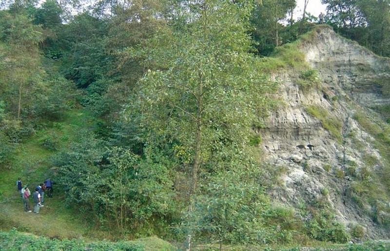
A combination of measures, implemented by a group of neighbouring families, is used to address landslips, gully formation and stream bank erosion problems in the middle hills of Nepal. All these processes affect the stability of adjacent agricultural land and cause problems downstream. Small-scale farming is dominant in the area surrounding the treated land - which theoretically belongs to the government but is used by these families.
This pilot technological package is proving suitable in Nepal for steep/very steep slopes under subhumid climates within an altitudinal range of 1,000-1,500 m a.s.l. This type of intervention, combined with the active involvement of stakeholders (who contribute three quarters of the cost), was recently introduced to Nepal under a watershed management programme, co-funded by the European Commission (see related approach ‘Integrated watershed management’).
Initially, ditches with bunds on the lower side are constructed along the contour. Within the gullies and along the stream banks, cement bags (filled with cement, brick chips, sand and/or earth) are placed to avoid deepening of the channel. Wattle fences, made from woven bamboo are also used as checks in the gullies. These structures are complemented by vegetative measures: Nepalese alder (Alnus nepalensis), bamboo (Dendrocalamus sp.), cardamom (Elettaria cardamomum), and broom grass (Thyosonaelana maxima) are planted. These species establish quickly in degraded sites and also control erosion, stabilise land and serve as cash crops, and for fodder, fuelwood and timber. Alder (locally called utis) is a nitrogen-fixing multipurpose tree which helps restore soil fertility.
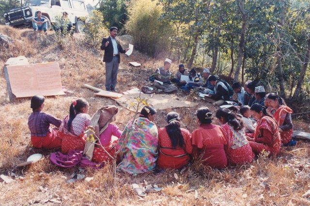
Farmers can get economic benefits within a few years from these plants. Another advantage of this package is that the vegetative resources needed are locally available and cheap. Furthermore farmers already know how to propagate them. Maintenance costs are negligible. Once established, the stabilised and revegetated sites provide improved environments for birds and insects – thus favouring biodiversity - and they help protect natural springs. In this case study, the economic returns from the cash crops mainly go to one family. Another few families also utilise this site, extracting common products (fodder, litter, timber) for domestic use. Additionally, the location is regularly used as an unofficial demonstration site, being visited by various people (farmers, SWC specialists) interested in the technology. This represents an indirect benefit to a larger number of people and strengthens institutions at household and community levels.
2.3 Photos of the Technology
Media Gallery
2.5 Country/ region/ locations where the Technology has been applied and which are covered by this assessment
Country:
Nepal
Region/ State/ Province:
Kathmandu
Further specification of location:
Kathmandu/Bagmati watershed
Specify the spread of the Technology:
- evenly spread over an area
If the Technology is evenly spread over an area, specify area covered (in km2):
0.14
If precise area is not known, indicate approximate area covered:
- 0.1-1 km2
Comments:
Total area covered by the SLM Technology is 0.14 km2.
The Approach covered a bigger area. This is just one example.
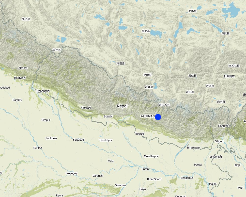
Map
×2.6 Date of implementation
If precise year is not known, indicate approximate date:
- more than 50 years ago (traditional)
2.7 Introduction of the Technology
Specify how the Technology was introduced:
- through projects/ external interventions
3. Classification of the SLM Technology
3.1 Main purpose(s) of the Technology
- reduce, prevent, restore land degradation
3.2 Current land use type(s) where the Technology is applied
Land use mixed within the same land unit:
Yes
Specify mixed land use (crops/ grazing/ trees):
- Silvo-pastoralism

Grazing land

Forest/ woodlands
Type of tree:
- Bamboo bamboo
- Nepalese Alder (Alnus nepalensis)

Unproductive land
Specify:
Wasteland (degraded shrubland before SWC)
Remarks:
degraded , no annual crops, occasionally grazed
Comments:
Major cash crop: Nepalese Alder (Alnus nepalensis), Bamboo (Dendroc) and broom grass (Thysanolaena maxima)
Major land use problems (compiler’s opinion): - concentrated runoff from upstream agricultural areas
- landslides, gullies and stream bank erosion
- gullies back-cutting into fertile agricultural land and threatening irrigation canals and homesteads
Major land use problems (land users’ perception): Landslide and gully erosion due to poor vegetative cover (steepness and lack of effective drainage/ diversion system).
Future (final) land use (after implementation of SLM Technology): Mixed: Ma: Agro-silvopastoralism
Constraints of wastelands (degraded shrubland) (before SWC) (degraded , no annual crops, occasionally grazed)
Number of growing seasons per year: 2
Longest growing period in days: 180 Longest growing period from month to month: Jun - Nov
3.4 Water supply
Water supply for the land on which the Technology is applied:
- rainfed
3.5 SLM group to which the Technology belongs
- cross-slope measure
- ecosystem-based disaster risk reduction
3.6 SLM measures comprising the Technology

vegetative measures
- V1: Tree and shrub cover

structural measures
- S2: Bunds, banks
3.7 Main types of land degradation addressed by the Technology

soil erosion by water
- Wg: gully erosion/ gullying
- Wm: mass movements/ landslides
- Wr: riverbank erosion

chemical soil deterioration
- Cn: fertility decline and reduced organic matter content (not caused by erosion)
Comments:
Main causes of degradation: deforestation / removal of natural vegetation (incl. forest fires), education, access to knowledge and support services (lack of knowledge)
3.8 Prevention, reduction, or restoration of land degradation
Specify the goal of the Technology with regard to land degradation:
- prevent land degradation
- reduce land degradation
Comments:
Secondary goals: rehabilitation / reclamation of denuded land
4. Technical specifications, implementation activities, inputs, and costs
4.1 Technical drawing of the Technology
Technical specifications (related to technical drawing):
Land slip and stream bank protection: an overview of the multiple and integrated vegetative and structural measures: cut-off drain
1. landslip area
2. banana trees
3. alder trees
4. bamboo wattle fences
5. cardamom
6. planting bamboo
7. cement bag check dams
8. broom grass
9. cutting bamboo
10. stream bank
11. agricultural fi elds in a fl at area
Insert 1: Bamboo wattle fence
combined with retention ditch and
grassed bund to stabilise steep slopes and gullies.
Insert 2: Old cement bags fi lled to
form checks in gullies
Technical knowledge required for field staff / advisors: high
Technical knowledge required for land users: high
Main technical functions: control of concentrated runoff: impede / retard, reduction of slope angle, reduction of slope length, improvement of ground cover, stabilisation of soil
Secondary technical functions: control of concentrated runoff: drain / divert, increase of infiltration, introduction of cash crop
Scattered / dispersed
Vegetative material: T : trees / shrubs, F : fruit trees / shrubs, C : perennial crops, G : grass
Vertical interval within rows / strips / blocks (m): 2 m
Trees/ shrubs species: Alnus nepalenses
Fruit trees / shrubs species: Dendrocalamus sp.
Perennial crops species: Large cardamom
Grass species: Broom grass
Diversion ditch/ drainage
Spacing between structures (m): 10 m
Depth of ditches/pits/dams (m): 0.25 m
Width of ditches/pits/dams (m): 0.1 m
Length of ditches/pits/dams (m): 10 m
Terrace: forward sloping
Spacing between structures (m): 10 m
Structural measure: sediment sand / trap
Vertical interval between structures (m): 1-4 m
Spacing between structures (m): 0.3 m
Depth of ditches/pits/dams (m): 3-4 m
Width of ditches/pits/dams (m): 0.8 m
Structural measure: cement bags
Structural measure: wattle fences
Construction material (concrete): Sand/cement .
Construction material (other): Bamboo culm cutting (1.5 m long)
Slope (which determines the spacing indicated above): 100%
If the original slope has changed as a result of the Technology, the slope today is: 15%
Vegetation is used for stabilisation of structures.
Author:
Mats Gurtner
4.2 General information regarding the calculation of inputs and costs
Specify how costs and inputs were calculated:
- per Technology area
Indicate size and area unit:
1.4 ha
Specify currency used for cost calculations:
- USD
Indicate average wage cost of hired labour per day:
1.35
4.3 Establishment activities
| Activity | Timing (season) | |
|---|---|---|
| 1. | Preparing site for implementation of vegetative measures | June |
| 2. | Planting of alder (Alnus nepalensis,), cardamom (Elettaria cardamomum), | July - August |
| 3. | Watering of new plants using buckets | Mar- May (1st year) |
| 4. | Application of farmyard manure at time of planting | Time of planting and every December |
| 5. | Weeding | January |
| 6. | Earthing up new plants with soil | January |
| 7. | Construction of contour bunds and ditches | January–April |
| 8. | Stabilisation of slopes using bamboo wattle fences, and gullies using the check dams | |
| 9. | Gully stabilisation as walls of cement bags are placed across the gullies and along stream banks | June |
| 10. | Preparing the site for planting | June |
4.4 Costs and inputs needed for establishment
| Specify input | Unit | Quantity | Costs per Unit | Total costs per input | % of costs borne by land users | |
|---|---|---|---|---|---|---|
| Labour | Stabilisation of gully and vegetative measures | Persons/day | 1567.0 | 1.35 | 2115.45 | 75.0 |
| Equipment | Tools | ha | 1.0 | 55.0 | 55.0 | 100.0 |
| Equipment | Empty cement bags | pieces | 600.0 | 0.0166666 | 10.0 | |
| Plant material | Bamboo cuttings | pieces | 600.0 | 0.9416666 | 565.0 | 50.0 |
| Fertilizers and biocides | Compost / manure | ha | 1.0 | 10.0 | 10.0 | 10.0 |
| Construction material | Cement bags filled | pieces | 30.0 | 4.166666 | 125.0 | |
| Construction material | Alder saplings | pieces | 2500.0 | 0.016 | 40.0 | 100.0 |
| Construction material | Seedlings cardamon | pieces | 400.0 | 0.0125 | 5.0 | |
| Total costs for establishment of the Technology | 2925.45 | |||||
| Total costs for establishment of the Technology in USD | 2925.45 | |||||
If land user bore less than 100% of costs, indicate who covered the remaining costs:
By different stakeholders
Comments:
Duration of establishment phase: 12 month(s)
4.5 Maintenance/ recurrent activities
| Activity | Timing/ frequency | |
|---|---|---|
| 1. | Apply farmyard manure | January /1 |
| 2. | Weed | January /1 |
| 3. | Prepare land for further planting of large cardamom and broom grass | March-April /1 |
| 4. | Thin cardamom, bamboo, alder, broom grass with a knife: | May,June /1 |
| 5. | Replant cardamom, broom grass, bamboo that did not establish | June,July /1 |
| 6. | Earth up | Aug-Sep and January /1 |
| 7. | Prune alders | December.,January /1 |
4.6 Costs and inputs needed for maintenance/ recurrent activities (per year)
| Specify input | Unit | Quantity | Costs per Unit | Total costs per input | % of costs borne by land users | |
|---|---|---|---|---|---|---|
| Labour | Maintaining plants | Persons/day | 41.0 | 1.35 | 55.35 | 100.0 |
| Equipment | Tools | ha | 1.0 | 10.0 | 10.0 | 100.0 |
| Plant material | Compost / manure | ha | 1.0 | 5.0 | 5.0 | 100.0 |
| Total costs for maintenance of the Technology | 70.35 | |||||
| Total costs for maintenance of the Technology in USD | 70.35 | |||||
Comments:
Machinery/ tools: Activities are carried out manually using local and traditional tools:
The costs (per ha) are calculated for the entire SWC site (consisting of 1.4 ha) including all establishment and maintenance inputs. Labour costs: information based on oral information by farmer. Estimate was approx. 3 people per working day over 2 years.
4.7 Most important factors affecting the costs
Describe the most determinate factors affecting the costs:
labour is the major input.
5. Natural and human environment
5.1 Climate
Annual rainfall
- < 250 mm
- 251-500 mm
- 501-750 mm
- 751-1,000 mm
- 1,001-1,500 mm
- 1,501-2,000 mm
- 2,001-3,000 mm
- 3,001-4,000 mm
- > 4,000 mm
Agro-climatic zone
- humid
Thermal climate class: subtropics
5.2 Topography
Slopes on average:
- flat (0-2%)
- gentle (3-5%)
- moderate (6-10%)
- rolling (11-15%)
- hilly (16-30%)
- steep (31-60%)
- very steep (>60%)
Landforms:
- plateau/plains
- ridges
- mountain slopes
- hill slopes
- footslopes
- valley floors
Altitudinal zone:
- 0-100 m a.s.l.
- 101-500 m a.s.l.
- 501-1,000 m a.s.l.
- 1,001-1,500 m a.s.l.
- 1,501-2,000 m a.s.l.
- 2,001-2,500 m a.s.l.
- 2,501-3,000 m a.s.l.
- 3,001-4,000 m a.s.l.
- > 4,000 m a.s.l.
Comments and further specifications on topography:
Slopes on average: Also hilly
5.3 Soils
Soil depth on average:
- very shallow (0-20 cm)
- shallow (21-50 cm)
- moderately deep (51-80 cm)
- deep (81-120 cm)
- very deep (> 120 cm)
Soil texture (topsoil):
- coarse/ light (sandy)
- medium (loamy, silty)
Topsoil organic matter:
- medium (1-3%)
If available, attach full soil description or specify the available information, e.g. soil type, soil PH/ acidity, Cation Exchange Capacity, nitrogen, salinity etc.
Soil fertility is low (sandy) - medium (loam)
Soil drainage / infiltration is medium
Soil water storage capacity is low
5.6 Characteristics of land users applying the Technology
Market orientation of production system:
- subsistence (self-supply)
- mixed (subsistence/ commercial)
Off-farm income:
- 10-50% of all income
Relative level of wealth:
- average
Level of mechanization:
- manual work
Indicate other relevant characteristics of the land users:
Population density: 200-500 persons/km2
Annual population growth: 2% - 3%
2% of the land users are very rich and own 40% of the land.
5% of the land users are rich and own 30% of the land.
85% of the land users are average wealthy and own 15% of the land.
3% of the land users are poor and own 10% of the land.
3% of the land users are poor and own 5% of the land.
Off-farm income specification: Off-farm activities: occasionally teaching at farmer's school; selling non-timber forest products on the market; some people workin markets/shops/onconstruction, sites, and similar ..
5.7 Average area of land used by land users applying the Technology
- < 0.5 ha
- 0.5-1 ha
- 1-2 ha
- 2-5 ha
- 5-15 ha
- 15-50 ha
- 50-100 ha
- 100-500 ha
- 500-1,000 ha
- 1,000-10,000 ha
- > 10,000 ha
5.8 Land ownership, land use rights, and water use rights
Land ownership:
- state
Land use rights:
- open access (unorganized)
6. Impacts and concluding statements
6.1 On-site impacts the Technology has shown
Socio-economic impacts
Production
fodder production
fodder quality
wood production
Comments/ specify:
including fuel wood
Income and costs
farm income
Comments/ specify:
cash crop introduction
workload
Comments/ specify:
high during establishment, low during maintenance
Other socio-economic impacts
input constraints
Comments/ specify:
high during establishment, low during maintenance
input constraints for maintenance
Socio-cultural impacts
health situation
Comments/ specify:
due to cardamom’s medicinal properties
community institutions
Comments/ specify:
by way of community resource mobilisation (e.g. as a result of common establishment activities; visits to the site by outsiders)
national institutions
SLM/ land degradation knowledge
conflict mitigation
Comments/ specify:
especially in case of insecure land tenureship
Illegal extract of non-timber forest products
Comments/ specify:
because of remoteness
Ecological impacts
Water cycle/ runoff
surface runoff
Quantity before SLM:
80 m3/ha/y
Quantity after SLM:
35 m3/ha/y
excess water drainage
Soil
soil moisture
soil cover
soil loss
Quantity before SLM:
200 t/ha/y
Quantity after SLM:
10 t/ha/yr
Other ecological impacts
soil erosion and sediment transport(locally)
Comments/ specify:
soil erosion increase and increased sediment transport locally during establishment of structural measures (construction of wattle fences, terraces, cement bag walls in gullies)
6.2 Off-site impacts the Technology has shown
reliable and stable stream flows in dry season
downstream flooding
downstream siltation
groundwater/ river pollution
stabilisation of upstream agricultural land
Comments/ specify:
The agricultural land which is located on the upper portion of the SWC area is stabilised
runoff/transported sediments
grazing pressure
Comments/ specify:
grazing pressure will increase on another site because of the SWC site is closed for grazing
6.3 Exposure and sensitivity of the Technology to gradual climate change and climate-related extremes/ disasters (as perceived by land users)
Gradual climate change
Gradual climate change
| Season | increase or decrease | How does the Technology cope with it? | |
|---|---|---|---|
| annual temperature | increase | well |
Climate-related extremes (disasters)
Meteorological disasters
| How does the Technology cope with it? | |
|---|---|
| local rainstorm | not well |
| local windstorm | well |
Climatological disasters
| How does the Technology cope with it? | |
|---|---|
| drought | well |
Hydrological disasters
| How does the Technology cope with it? | |
|---|---|
| general (river) flood | not well |
Other climate-related consequences
Other climate-related consequences
| How does the Technology cope with it? | |
|---|---|
| reduced growing period | well |
6.4 Cost-benefit analysis
How do the benefits compare with the establishment costs (from land users’ perspective)?
Short-term returns:
negative
Long-term returns:
very positive
How do the benefits compare with the maintenance/ recurrent costs (from land users' perspective)?
Short-term returns:
positive
Long-term returns:
very positive
6.5 Adoption of the Technology
- > 50%
If available, quantify (no. of households and/ or area covered):
38 households in an area of 1.4 ha
Of all those who have adopted the Technology, how many did so spontaneously, i.e. without receiving any material incentives/ payments?
- 51-90%
Comments:
47% of land user families have adopted the Technology with external material support
18 land user families have adopted the Technology with external material support
Comments on acceptance with external material support: survey results
53% of land user families have adopted the Technology without any external material support
20 land user families have adopted the Technology without any external material support
Comments on spontaneous adoption: survey results
There is a moderate trend towards spontaneous adoption of the Technology
Comments on adoption trend: estimates by the authors, based on the past trends of adoption.
6.7 Strengths/ advantages/ opportunities of the Technology
| Strengths/ advantages/ opportunities in the land user’s view |
|---|
|
Family members have learnt the technology. it is easy to replicate. How can they be sustained / enhanced? Provide training and schooling to farmers to spread this information to others (eg through village initiatives supported by government). |
|
Better environment, increased biodiversity How can they be sustained / enhanced? As above |
|
Soil and water conservation How can they be sustained / enhanced? As above |
|
Fresh products, health benefits from cardamom How can they be sustained / enhanced? As above |
|
Income generation from cash cropping of cardamom, bamboo, broom grass) How can they be sustained / enhanced? As above |
| Strengths/ advantages/ opportunities in the compiler’s or other key resource person’s view |
|---|
|
The technology requires resources which are largely locally available and of low costs. How can they be sustained / enhanced? Raise awareness that landslide threatened stream banks and steep slops can be protected using local resources. |
|
Technology addresses livelihood constraints How can they be sustained / enhanced? Raise awareness that the technology is profitable. |
6.8 Weaknesses/ disadvantages/ risks of the Technology and ways of overcoming them
| Weaknesses/ disadvantages/ risks in the compiler’s or other key resource person’s view | How can they be overcome? |
|---|---|
| The technology is adopted more by better ressourced farmers | Government programmes should seek to involve poor farmers in land development with incentives for adopting recommennded technologies |
| Establishment costs are high | Subsidise the cost (extension service, projects), reduce establishment costs by designing alternative structural measures without use of cement. |
| Socio-economic conflicts can arise when the value of land is raised | Take equity issues into account when implementing such a programme, and spread the benefits. |
| Establishment is very labour intensive. |
7. References and links
7.1 Methods/ sources of information
7.2 References to available publications
Title, author, year, ISBN:
IBIWMP (2003) Engineering Field Manual. Kathmandu: Government of Nepal, Department of Soil Conservation and Watershed Management Programme,Bagmati Integrated Watershed Management
Title, author, year, ISBN:
Howell, J. (ed) (1999) Roadside Bio-engineering Reference Manual. Kathmandu: Government of Nepal, Department of Roads
Links and modules
Expand all Collapse allLinks
Integrated watershed management for landslip and stream bank … [Nepal]
Integrated watershed management as an example for landslip and stream bank stabilisation based on fostering a partnership between community institutions, line agencies, district authorities and consultants
- Compiler: Dileep Kumar Karna
Modules
No modules