Landslip and stream bank stabilisation [เนปาล]
- ผู้สร้างสรรค์:
- การอัพเดท:
- ผู้รวบรวม: Dileep Kumar Karna
- ผู้เรียบเรียง: –
- ผู้ตรวจสอบ: David Streiff, Deborah Niggli, Alexandra Gavilano
Bans ko bhatta, Manra bandhi (Nepali)
technologies_1491 - เนปาล
ดูส่วนย่อย
ขยายทั้งหมด ย่อทั้งหมด1. ข้อมูลทั่วไป
1.2 รายละเอียดที่ติดต่อได้ของผู้รวบรวมและองค์กรที่เกี่ยวข้องในการประเมินและการจัดเตรียมทำเอกสารของเทคโนโลยี
ผู้เชี่ยวชาญ SLM:
ผู้เชี่ยวชาญ SLM:
ผู้เชี่ยวชาญ SLM:
ผู้เชี่ยวชาญ SLM:
ผู้เชี่ยวชาญ SLM:
ผู้เชี่ยวชาญ SLM:
ผู้เชี่ยวชาญ SLM:
Singh Bijendra
DSCO
เนปาล
ผู้ใช้ที่ดิน:
Basnet Druba P.
เนปาล
ผู้เชี่ยวชาญ SLM:
ชื่อของโครงการซึ่งอำนวยความสะดวกในการทำเอกสารหรือการประเมินเทคโนโลยี (ถ้าเกี่ยวข้อง)
People and Resource Dynamics Project, Nepal (PARDYP)ชื่อของโครงการซึ่งอำนวยความสะดวกในการทำเอกสารหรือการประเมินเทคโนโลยี (ถ้าเกี่ยวข้อง)
Book project: where the land is greener - Case Studies and Analysis of Soil and Water Conservation Initiatives Worldwide (where the land is greener)ชื่อขององค์กรซึ่งอำนวยความสะดวกในการทำเอกสารหรือการประเมินเทคโนโลยี (ถ้าเกี่ยวข้อง)
District Soil Conservation Office (DSCO) - เนปาลชื่อขององค์กรซึ่งอำนวยความสะดวกในการทำเอกสารหรือการประเมินเทคโนโลยี (ถ้าเกี่ยวข้อง)
ICIMOD International Centre for Integrated Mountain Development (ICIMOD) - เนปาลชื่อขององค์กรซึ่งอำนวยความสะดวกในการทำเอกสารหรือการประเมินเทคโนโลยี (ถ้าเกี่ยวข้อง)
Chittagong Hill Tracts Development Board (CHTDB) - บังกลาเทศชื่อขององค์กรซึ่งอำนวยความสะดวกในการทำเอกสารหรือการประเมินเทคโนโลยี (ถ้าเกี่ยวข้อง)
G.B. Pant Institute of Himalayan Einvironment & Development (G.B. Pant Institute of Himalayan Einvironment & Development) - อินเดียชื่อขององค์กรซึ่งอำนวยความสะดวกในการทำเอกสารหรือการประเมินเทคโนโลยี (ถ้าเกี่ยวข้อง)
CSKHPKV Palampur (CSKHPKV Palampur) - อินเดีย1.3 เงื่อนไขการใช้ข้อมูลที่ได้บันทึกผ่านทาง WOCAT
ผู้รวบรวมและวิทยากรหลักยอมรับเงื่อนไขเกี่ยวกับการใช้ข้อมูลที่ถูกบันทึกผ่านทาง WOCAT:
ใช่
1.5 Reference to Questionnaire(s) on SLM Approaches (documented using WOCAT)
Integrated watershed management for landslip and stream bank … [เนปาล]
Integrated watershed management as an example for landslip and stream bank stabilisation based on fostering a partnership between community institutions, line agencies, district authorities and consultants
- ผู้รวบรวม: Dileep Kumar Karna
2. การอธิบายลักษณะของเทคโนโลยี SLM
2.1 การอธิบายแบบสั้น ๆ ของเทคโนโลยี
คำจำกัดความของเทคโนโลยี:
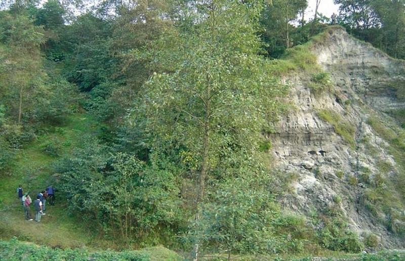
Integration of vegetative and structural measures for landslip, stream bank and gully stabilisation on hillsides.
2.2 การอธิบายแบบละเอียดของเทคโนโลยี
คำอธิบาย:
A combination of measures, implemented by a group of neighbouring families, is used to address landslips, gully formation and stream bank erosion problems in the middle hills of Nepal. All these processes affect the stability of adjacent agricultural land and cause problems downstream. Small-scale farming is dominant in the area surrounding the treated land - which theoretically belongs to the government but is used by these families.
This pilot technological package is proving suitable in Nepal for steep/very steep slopes under subhumid climates within an altitudinal range of 1,000-1,500 m a.s.l. This type of intervention, combined with the active involvement of stakeholders (who contribute three quarters of the cost), was recently introduced to Nepal under a watershed management programme, co-funded by the European Commission (see related approach ‘Integrated watershed management’).
Initially, ditches with bunds on the lower side are constructed along the contour. Within the gullies and along the stream banks, cement bags (filled with cement, brick chips, sand and/or earth) are placed to avoid deepening of the channel. Wattle fences, made from woven bamboo are also used as checks in the gullies. These structures are complemented by vegetative measures: Nepalese alder (Alnus nepalensis), bamboo (Dendrocalamus sp.), cardamom (Elettaria cardamomum), and broom grass (Thyosonaelana maxima) are planted. These species establish quickly in degraded sites and also control erosion, stabilise land and serve as cash crops, and for fodder, fuelwood and timber. Alder (locally called utis) is a nitrogen-fixing multipurpose tree which helps restore soil fertility.
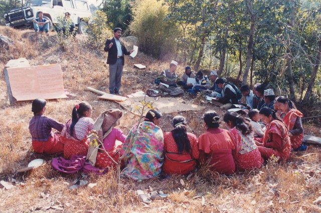
Farmers can get economic benefits within a few years from these plants. Another advantage of this package is that the vegetative resources needed are locally available and cheap. Furthermore farmers already know how to propagate them. Maintenance costs are negligible. Once established, the stabilised and revegetated sites provide improved environments for birds and insects – thus favouring biodiversity - and they help protect natural springs. In this case study, the economic returns from the cash crops mainly go to one family. Another few families also utilise this site, extracting common products (fodder, litter, timber) for domestic use. Additionally, the location is regularly used as an unofficial demonstration site, being visited by various people (farmers, SWC specialists) interested in the technology. This represents an indirect benefit to a larger number of people and strengthens institutions at household and community levels.
2.3 รูปภาพของเทคโนโลยี
อัลบั้มสื่อบันทึก
2.5 ประเทศภูมิภาค หรือสถานที่ตั้งที่เทคโนโลยีได้นำไปใช้และได้รับการครอบคลุมโดยการประเมินนี้
ประเทศ:
เนปาล
ภูมิภาค/รัฐ/จังหวัด:
Kathmandu
ข้อมูลจำเพาะเพิ่มเติมของสถานที่ตั้ง :
Kathmandu/Bagmati watershed
ระบุการกระจายตัวของเทคโนโลยี:
- กระจายไปอย่างสม่ำเสมอในพื้นที่
If the Technology is evenly spread over an area, specify area covered (in km2):
0.14
If precise area is not known, indicate approximate area covered:
- 0.1-1 ตร.กม.
แสดงความคิดเห็น:
Total area covered by the SLM Technology is 0.14 km2.
The Approach covered a bigger area. This is just one example.
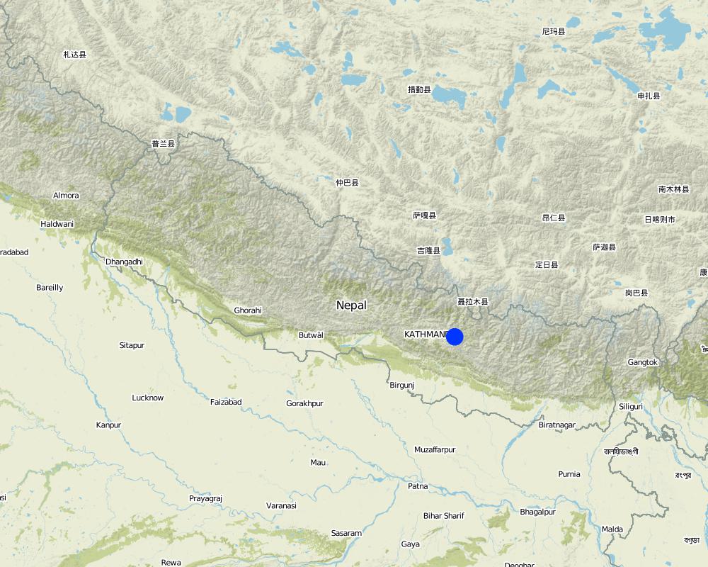
Map
×2.6 วันที่การดำเนินการ
ถ้าไม่รู้ปีที่แน่นอน ให้ระบุวันที่โดยประมาณ:
- มากกว่า 50 ปี (แบบดั้งเดิม)
2.7 คำแนะนำของเทคโนโลยี
ให้ระบุว่าเทคโนโลยีถูกแนะนำเข้ามาอย่างไร:
- ทางโครงการหรือจากภายนอก
3. การจัดประเภทของเทคโนโลยี SLM
3.1 วัตถุประสงค์หลักของเทคโนโลยี
- ลด ป้องกัน ฟื้นฟู การเสื่อมโทรมของที่ดิน
3.2 ประเภทของการใช้ที่ดินในปัจจุบันที่ได้นำเทคโนโลยีไปใช้
Land use mixed within the same land unit:
ใช่
Specify mixed land use (crops/ grazing/ trees):
- ปศุสัตว์ร่วมกับการทำป่าไม้ (Silvo-pastoralism)

ทุ่งหญ้าเลี้ยงสัตว์

ป่า/พื้นที่ทำไม้
Type of tree:
- Bamboo bamboo
- Nepalese Alder (Alnus nepalensis)

ที่ดินที่ไม่ให้ผลผลิต
ระบุ:
Wasteland (degraded shrubland before SWC)
ข้อสังเกต:
degraded , no annual crops, occasionally grazed
แสดงความคิดเห็น:
Major cash crop: Nepalese Alder (Alnus nepalensis), Bamboo (Dendroc) and broom grass (Thysanolaena maxima)
Major land use problems (compiler’s opinion): - concentrated runoff from upstream agricultural areas
- landslides, gullies and stream bank erosion
- gullies back-cutting into fertile agricultural land and threatening irrigation canals and homesteads
Major land use problems (land users’ perception): Landslide and gully erosion due to poor vegetative cover (steepness and lack of effective drainage/ diversion system).
Future (final) land use (after implementation of SLM Technology): Mixed: Ma: Agro-silvopastoralism
Constraints of wastelands (degraded shrubland) (before SWC) (degraded , no annual crops, occasionally grazed)
Number of growing seasons per year: 2
Longest growing period in days: 180 Longest growing period from month to month: Jun - Nov
3.4 การใช้น้ำ
การใช้น้ำของที่ดินที่มีการใช้เทคโนโลยีอยู่:
- จากน้ำฝน
3.5 กลุ่ม SLM ที่ตรงกับเทคโนโลยีนี้
- มาตรการปลูกพืชขวางความลาดชัน (cross-slope measure)
- การลดความเสี่ยงจากภัยพิบัติบนพื้นฐานของระบบนิเวศ
3.6 มาตรการ SLM ที่ประกอบกันเป็นเทคโนโลยี

มาตรการอนุรักษ์ด้วยวิธีพืช
- V1: ต้นไม้และพุ่มไม้คลุมดิน

มาตรการอนุรักษ์ด้วยโครงสร้าง
- S2: ทำนบ เขื่อนดิน
3.7 รูปแบบหลักของการเสื่อมโทรมของที่ดินที่ได้รับการแก้ไขโดยเทคโนโลยี

การกัดกร่อนของดินโดยน้ำ
- Wg (Gully erosion): การกัดกร่อนแบบร่องธารหรือการทำให้เกิดร่องน้ำเซาะ
- Wm (Mass movement): การเคลื่อนตัวของมวลดินหรือดินถล่ม
- Wr (Riverbank erosion): การกัดกร่อนริมฝั่งแม่น้ำ

การเสื่อมโทรมของดินทางด้านเคมี
- Cn (Fertility decline): ความอุดมสมบูรณ์และปริมาณอินทรียวัตถุในดินถูกทำให้ลดลงไป (ไม่ได้เกิดจากสาเหตุการกัดกร่อน)
แสดงความคิดเห็น:
Main causes of degradation: deforestation / removal of natural vegetation (incl. forest fires), education, access to knowledge and support services (lack of knowledge)
3.8 การป้องกัน การลดลง หรือการฟื้นฟูความเสื่อมโทรมของที่ดิน
ระบุเป้าหมายของเทคโนโลยีกับความเสื่อมโทรมของที่ดิน:
- ป้องกันความเสื่อมโทรมของที่ดิน
- ลดความเสื่อมโทรมของดิน
แสดงความคิดเห็น:
Secondary goals: rehabilitation / reclamation of denuded land
4. ข้อมูลจำเพาะด้านเทคนิค กิจกรรมการนำไปปฏิบัติใช้ ปัจจัยนำเข้า และค่าใช้จ่าย
4.1 แบบแปลนทางเทคนิคของเทคโนโลยี
ข้อมูลจำเพาะด้านเทคนิค (แบบแปลนทางเทคนิคของเทคโนโลยี):
Land slip and stream bank protection: an overview of the multiple and integrated vegetative and structural measures: cut-off drain
1. landslip area
2. banana trees
3. alder trees
4. bamboo wattle fences
5. cardamom
6. planting bamboo
7. cement bag check dams
8. broom grass
9. cutting bamboo
10. stream bank
11. agricultural fi elds in a fl at area
Insert 1: Bamboo wattle fence
combined with retention ditch and
grassed bund to stabilise steep slopes and gullies.
Insert 2: Old cement bags fi lled to
form checks in gullies
Technical knowledge required for field staff / advisors: high
Technical knowledge required for land users: high
Main technical functions: control of concentrated runoff: impede / retard, reduction of slope angle, reduction of slope length, improvement of ground cover, stabilisation of soil
Secondary technical functions: control of concentrated runoff: drain / divert, increase of infiltration, introduction of cash crop
Scattered / dispersed
Vegetative material: T : trees / shrubs, F : fruit trees / shrubs, C : perennial crops, G : grass
Vertical interval within rows / strips / blocks (m): 2 m
Trees/ shrubs species: Alnus nepalenses
Fruit trees / shrubs species: Dendrocalamus sp.
Perennial crops species: Large cardamom
Grass species: Broom grass
Diversion ditch/ drainage
Spacing between structures (m): 10 m
Depth of ditches/pits/dams (m): 0.25 m
Width of ditches/pits/dams (m): 0.1 m
Length of ditches/pits/dams (m): 10 m
Terrace: forward sloping
Spacing between structures (m): 10 m
Structural measure: sediment sand / trap
Vertical interval between structures (m): 1-4 m
Spacing between structures (m): 0.3 m
Depth of ditches/pits/dams (m): 3-4 m
Width of ditches/pits/dams (m): 0.8 m
Structural measure: cement bags
Structural measure: wattle fences
Construction material (concrete): Sand/cement .
Construction material (other): Bamboo culm cutting (1.5 m long)
Slope (which determines the spacing indicated above): 100%
If the original slope has changed as a result of the Technology, the slope today is: 15%
Vegetation is used for stabilisation of structures.
ผู้เขียน:
Mats Gurtner
4.2 ข้อมูลทั่วไปเกี่ยวกับการคำนวณปัจจัยนำเข้าและค่าใช้จ่าย
ให้ระบุว่าค่าใช้จ่ายและปัจจัยนำเข้าได้รับการคำนวณอย่างไร:
- ต่อพื้นที่ที่ใช้เทคโนโลยี
ระบุขนาดและหน่วยพื้นที่:
1.4 ha
ระบุสกุลเงินที่ใช้คำนวณค่าใช้จ่าย:
- USD
ระบุค่าเฉลี่ยของค่าจ้างในการจ้างแรงงานต่อวัน:
1.35
4.3 กิจกรรมเพื่อการจัดตั้ง
| กิจกรรม | Timing (season) | |
|---|---|---|
| 1. | Preparing site for implementation of vegetative measures | June |
| 2. | Planting of alder (Alnus nepalensis,), cardamom (Elettaria cardamomum), | July - August |
| 3. | Watering of new plants using buckets | Mar- May (1st year) |
| 4. | Application of farmyard manure at time of planting | Time of planting and every December |
| 5. | Weeding | January |
| 6. | Earthing up new plants with soil | January |
| 7. | Construction of contour bunds and ditches | January–April |
| 8. | Stabilisation of slopes using bamboo wattle fences, and gullies using the check dams | |
| 9. | Gully stabilisation as walls of cement bags are placed across the gullies and along stream banks | June |
| 10. | Preparing the site for planting | June |
4.4 ค่าใช้จ่ายของปัจจัยนำเข้าที่จำเป็นสำหรับการจัดตั้ง
| ปัจจัยนำเข้า | หน่วย | ปริมาณ | ค่าใช้จ่ายต่อหน่วย | ค่าใช้จ่ายทั้งหมดต่อปัจจัยนำเข้า | %ของค่าใช้จ่ายที่ก่อให้เกิดขึ้นโดยผู้ใช้ที่ดิน | |
|---|---|---|---|---|---|---|
| แรงงาน | Stabilisation of gully and vegetative measures | Persons/day | 1567.0 | 1.35 | 2115.45 | 75.0 |
| อุปกรณ์ | Tools | ha | 1.0 | 55.0 | 55.0 | 100.0 |
| อุปกรณ์ | Empty cement bags | pieces | 600.0 | 0.0166666 | 10.0 | |
| วัสดุด้านพืช | Bamboo cuttings | pieces | 600.0 | 0.9416666 | 565.0 | 50.0 |
| ปุ๋ยและสารฆ่า/ยับยั้งการเจริญเติบโตของสิ่งมีชีวิต (ไบโอไซด์) | Compost / manure | ha | 1.0 | 10.0 | 10.0 | 10.0 |
| วัสดุสำหรับก่อสร้าง | Cement bags filled | pieces | 30.0 | 4.166666 | 125.0 | |
| วัสดุสำหรับก่อสร้าง | Alder saplings | pieces | 2500.0 | 0.016 | 40.0 | 100.0 |
| วัสดุสำหรับก่อสร้าง | Seedlings cardamon | pieces | 400.0 | 0.0125 | 5.0 | |
| ค่าใช้จ่ายทั้งหมดของการจัดตั้งเทคโนโลยี | 2925.45 | |||||
| Total costs for establishment of the Technology in USD | 2925.45 | |||||
ถ้าผู้ใช้ที่ดินรับภาระน้อยกว่า 100% ของค่าใช้จ่าย ให้ระบุว่าใครเป็นผู้รับผิดชอบส่วนที่เหลือ:
By different stakeholders
แสดงความคิดเห็น:
Duration of establishment phase: 12 month(s)
4.5 การบำรุงรักษาสภาพหรือกิจกรรมที่เกิดขึ้นเป็นประจำ
| กิจกรรม | ช่วงระยะเวลา/ความถี่ | |
|---|---|---|
| 1. | Apply farmyard manure | January /1 |
| 2. | Weed | January /1 |
| 3. | Prepare land for further planting of large cardamom and broom grass | March-April /1 |
| 4. | Thin cardamom, bamboo, alder, broom grass with a knife: | May,June /1 |
| 5. | Replant cardamom, broom grass, bamboo that did not establish | June,July /1 |
| 6. | Earth up | Aug-Sep and January /1 |
| 7. | Prune alders | December.,January /1 |
4.6 ค่าใช้จ่ายของปัจจัยนำเข้าและกิจกรรมที่เกิดขึ้นเป็นประจำที่ต้องการการบำรุงรักษา (ต่อปี)
| ปัจจัยนำเข้า | หน่วย | ปริมาณ | ค่าใช้จ่ายต่อหน่วย | ค่าใช้จ่ายทั้งหมดต่อปัจจัยนำเข้า | %ของค่าใช้จ่ายที่ก่อให้เกิดขึ้นโดยผู้ใช้ที่ดิน | |
|---|---|---|---|---|---|---|
| แรงงาน | Maintaining plants | Persons/day | 41.0 | 1.35 | 55.35 | 100.0 |
| อุปกรณ์ | Tools | ha | 1.0 | 10.0 | 10.0 | 100.0 |
| วัสดุด้านพืช | Compost / manure | ha | 1.0 | 5.0 | 5.0 | 100.0 |
| ค่าใช้จ่ายทั้งหมดของการบำรุงรักษาสภาพเทคโนโลยี | 70.35 | |||||
| Total costs for maintenance of the Technology in USD | 70.35 | |||||
แสดงความคิดเห็น:
Machinery/ tools: Activities are carried out manually using local and traditional tools:
The costs (per ha) are calculated for the entire SWC site (consisting of 1.4 ha) including all establishment and maintenance inputs. Labour costs: information based on oral information by farmer. Estimate was approx. 3 people per working day over 2 years.
4.7 ปัจจัยสำคัญที่สุดที่มีผลกระทบต่อค่าใช้จ่าย
ปัจจัยสำคัญที่สุดที่มีผลกระทบต่อค่าใช้จ่ายต่างๆ:
labour is the major input.
5. สิ่งแวดล้อมทางธรรมชาติและของมนุษย์
5.1 ภูมิอากาศ
ฝนประจำปี
- < 250 ม.ม.
- 251-500 ม.ม.
- 501-750 ม.ม.
- 751-1,000 ม.ม.
- 1,001-1,500 ม.ม.
- 1,501-2,000 ม.ม.
- 2,001-3,000 ม.ม.
- 3,001-4,000 ม.ม.
- > 4,000 ม.ม.
เขตภูมิอากาศเกษตร
- ชื้น
Thermal climate class: subtropics
5.2 สภาพภูมิประเทศ
ค่าเฉลี่ยความลาดชัน:
- ราบเรียบ (0-2%)
- ลาดที่ไม่ชัน (3-5%)
- ปานกลาง (6-10%)
- เป็นลูกคลื่น (11-15%)
- เป็นเนิน (16-30%)
- ชัน (31-60%)
- ชันมาก (>60%)
ธรณีสัณฐาน:
- ที่ราบสูง/ที่ราบ
- สันเขา
- ไหล่เขา
- ไหล่เนินเขา
- ตีนเนิน
- หุบเขา
ระดับความสูง:
- 0-100 เมตร
- 101-500 เมตร
- 501-1,000 เมตร
- 1,001-1,500 เมตร
- 1,501-2,000 เมตร
- 2,001-2,500 เมตร
- 2,501-3,000 เมตร
- 3,001-4,000 เมตร
- > 4,000 เมตร
ความคิดเห็นและข้อมูลจำเพาะเพิ่มเติมเรื่องสภาพภูมิประเทศ:
Slopes on average: Also hilly
5.3 ดิน
ค่าเฉลี่ยความลึกของดิน:
- ตื้นมาก (0-20 ซ.ม.)
- ตื้น (21-50 ซ.ม.)
- ลึกปานกลาง (51-80 ซ.ม.)
- ลึก (81-120 ซ.ม.)
- ลึกมาก (>120 ซ.ม.)
เนื้อดิน (ดินชั้นบน):
- หยาบ/เบา (ดินทราย)
- ปานกลาง (ดินร่วน ทรายแป้ง)
อินทรียวัตถุในดิน:
- ปานกลาง (1-3%)
(ถ้ามี) ให้แนบคำอธิบายเรื่องดินแบบเต็มหรือระบุข้อมูลที่มีอยู่ เช่น ชนิดของดิน ค่า pH ของดินหรือความเป็นกรดของดิน ความสามารถในการแลกเปลี่ยนประจุบวก ไนโตรเจน ความเค็ม เป็นต้น:
Soil fertility is low (sandy) - medium (loam)
Soil drainage / infiltration is medium
Soil water storage capacity is low
5.6 ลักษณะของผู้ใช้ที่ดินที่นำเทคโนโลยีไปปฏิบัติใช้
แนวทางการตลาดของระบบการผลิต:
- เพื่อการยังชีพ (หาเลี้ยงตนเอง)
- mixed (subsistence/ commercial)
รายได้ที่มาจากนอกฟาร์ม:
- 10-50% ของรายได้ทั้งหมด
ระดับของความมั่งคั่งโดยเปรียบเทียบ:
- พอมีพอกิน
ระดับของการใช้เครื่องจักรกล:
- งานที่ใช้แรงกาย
ระบุลักษณะอื่นๆที่เกี่ยวข้องของผู้ใช้ที่ดิน:
Population density: 200-500 persons/km2
Annual population growth: 2% - 3%
2% of the land users are very rich and own 40% of the land.
5% of the land users are rich and own 30% of the land.
85% of the land users are average wealthy and own 15% of the land.
3% of the land users are poor and own 10% of the land.
3% of the land users are poor and own 5% of the land.
Off-farm income specification: Off-farm activities: occasionally teaching at farmer's school; selling non-timber forest products on the market; some people workin markets/shops/onconstruction, sites, and similar ..
5.7 Average area of land used by land users applying the Technology
- < 0.5 เฮกตาร์
- 0.5-1 เฮกตาร์
- 1-2 เฮกตาร์
- 2-5 เฮกตาร์
- 5-15 เฮกตาร์
- 15-50 เฮกตาร์
- 50-100 เฮกตาร์
- 100-500 เฮกตาร์
- 500-1,000 เฮกตาร์
- 1,000-10,000 เฮกตาร์
- >10,000 เฮกตาร์
5.8 กรรมสิทธิ์ในที่ดิน สิทธิในการใช้ที่ดินและสิทธิในการใช้น้ำ
กรรมสิทธิ์ในที่ดิน:
- รัฐ
สิทธิในการใช้ที่ดิน:
- เข้าถึงได้แบบเปิด (ไม่ได้จัดระเบียบ)
6. ผลกระทบและสรุปคำบอกกล่าว
6.1 ผลกระทบในพื้นที่ดำเนินการ (On-site) จากการใช้เทคโนโลยี
ผลกระทบทางด้านเศรษฐกิจและสังคม
การผลิต
การผลิตพืชที่ใช้เลี้ยงปศุสัตว์
คุณภาพพืชที่ใช้เลี้ยงปศุสัตว์
การผลิตไม้
แสดงความคิดเห็น/ระบุ:
including fuel wood
รายได้และค่าใช้จ่าย
รายได้จากฟาร์ม
แสดงความคิดเห็น/ระบุ:
cash crop introduction
ภาระงาน
แสดงความคิดเห็น/ระบุ:
high during establishment, low during maintenance
ผลกระทบทางด้านเศรษฐกิจและสังคมอื่น ๆ
input constraints
แสดงความคิดเห็น/ระบุ:
high during establishment, low during maintenance
input constraints for maintenance
ผลกระทบด้านสังคมวัฒนธรรมอื่น ๆ
สถานการณ์ด้านสุขภาพ
แสดงความคิดเห็น/ระบุ:
due to cardamom’s medicinal properties
สถาบันของชุมชน
แสดงความคิดเห็น/ระบุ:
by way of community resource mobilisation (e.g. as a result of common establishment activities; visits to the site by outsiders)
สถาบันแห่งชาติ
SLM หรือความรู้เรื่องความเสื่อมโทรมของที่ดิน
การบรรเทาความขัดแย้ง
แสดงความคิดเห็น/ระบุ:
especially in case of insecure land tenureship
Illegal extract of non-timber forest products
แสดงความคิดเห็น/ระบุ:
because of remoteness
ผลกระทบด้านนิเวศวิทยา
วัฐจักรน้ำหรือน้ำบ่า
น้ำไหลบ่าที่ผิวดิน
จำนวนก่อน SLM:
80 m3/ha/y
หลังจาก SLM:
35 m3/ha/y
การระบายน้ำส่วนเกิน
ดิน
ความชื้นในดิน
สิ่งปกคลุมดิน
การสูญเสียดิน
จำนวนก่อน SLM:
200 t/ha/y
หลังจาก SLM:
10 t/ha/yr
ผลกระทบด้านนิเวศวิทยาอื่น ๆ
soil erosion and sediment transport(locally)
แสดงความคิดเห็น/ระบุ:
soil erosion increase and increased sediment transport locally during establishment of structural measures (construction of wattle fences, terraces, cement bag walls in gullies)
6.2 ผลกระทบนอกพื้นที่ดำเนินการ (Off-site) จากการใช้เทคโนโลยี
การไหลของน้ำคงที่และสม่ำเสมอในช่วงฤดูแล้ง
น้ำท่วมพื้นที่ท้ายน้ำ
การทับถมของดินตะกอนพื้นที่ท้ายน้ำ
การเกิดมลพิษในน้ำบาดาลหรือแม่น้ำ
stabilisation of upstream agricultural land
แสดงความคิดเห็น/ระบุ:
The agricultural land which is located on the upper portion of the SWC area is stabilised
runoff/transported sediments
grazing pressure
แสดงความคิดเห็น/ระบุ:
grazing pressure will increase on another site because of the SWC site is closed for grazing
6.3 การเผชิญและความตอบสนองของเทคโนโลยีต่อการเปลี่ยนแปลงสภาพภูมิอากาศที่ค่อยเป็นค่อยไป และสภาพรุนแรงของภูมิอากาศ / ภัยพิบัติ (ที่รับรู้ได้โดยผู้ใช้ที่ดิน)
การเปลี่ยนแปลงสภาพภูมิอากาศที่ค่อยเป็นค่อยไป
การเปลี่ยนแปลงสภาพภูมิอากาศที่ค่อยเป็นค่อยไป
| ฤดู | increase or decrease | เทคโนโลยีมีวิธีการรับมืออย่างไร | |
|---|---|---|---|
| อุณหภูมิประจำปี | เพิ่มขึ้น | ดี |
สภาพรุนแรงของภูมิอากาศ (ภัยพิบัติ)
ภัยพิบัติทางอุตุนิยมวิทยา
| เทคโนโลยีมีวิธีการรับมืออย่างไร | |
|---|---|
| พายุฝนประจำท้องถิ่น | ไม่ค่อยดี |
| พายุลมประจำท้องถิ่น | ดี |
ภัยพิบัติจากสภาพภูมิอากาศ
| เทคโนโลยีมีวิธีการรับมืออย่างไร | |
|---|---|
| ภัยจากฝนแล้ง | ดี |
ภัยพิบัติจากน้ำ
| เทคโนโลยีมีวิธีการรับมืออย่างไร | |
|---|---|
| น้ำท่วมตามปกติ (แม่น้ำ) | ไม่ค่อยดี |
ผลลัพธ์ตามมาที่เกี่ยวข้องกับภูมิอากาศอื่น ๆ
ผลลัพธ์ตามมาที่เกี่ยวข้องกับภูมิอากาศอื่น ๆ
| เทคโนโลยีมีวิธีการรับมืออย่างไร | |
|---|---|
| ช่วงการปลูกพืชที่ลดลงมา | ดี |
6.4 การวิเคราะห์ค่าใช้จ่ายและผลประโยชน์ที่ได้รับ
ผลประโยชน์ที่ได้รับเปรียบเทียบกับค่าใช้จ่ายในการจัดตั้งเป็นอย่างไร (จากมุมมองของผู้ใช้ที่ดิน)
ผลตอบแทนระยะสั้น:
ด้านลบ
ผลตอบแทนระยะยาว:
ด้านบวกอย่างมาก
ผลประโยชน์ที่ได้รับเปรียบเทียบกับค่าใช้จ่ายในการบำรุงรักษาหรือต้นทุนที่เกิดขึ้นซ้ำอีก เป็นอย่างไร (จากมุมมองของผู้ใช้ที่ดิน)
ผลตอบแทนระยะสั้น:
ด้านบวก
ผลตอบแทนระยะยาว:
ด้านบวกอย่างมาก
6.5 การปรับตัวของเทคโนโลยี
- > 50%
ถ้ามีข้อมูลให้บอกปริมาณด้วย (จำนวนของครัวเรือนหรือครอบคลุมพื้นที่):
38 households in an area of 1.4 ha
Of all those who have adopted the Technology, how many did so spontaneously, i.e. without receiving any material incentives/ payments?
- 51-90%
แสดงความคิดเห็น:
47% of land user families have adopted the Technology with external material support
18 land user families have adopted the Technology with external material support
Comments on acceptance with external material support: survey results
53% of land user families have adopted the Technology without any external material support
20 land user families have adopted the Technology without any external material support
Comments on spontaneous adoption: survey results
There is a moderate trend towards spontaneous adoption of the Technology
Comments on adoption trend: estimates by the authors, based on the past trends of adoption.
6.7 จุดแข็ง / ข้อได้เปรียบ / โอกาสของเทคโนโลยี
| จุดแข็ง / ข้อได้เปรียบ / โอกาสในทัศนคติของผู้ใช้ที่ดิน |
|---|
|
Family members have learnt the technology. it is easy to replicate. How can they be sustained / enhanced? Provide training and schooling to farmers to spread this information to others (eg through village initiatives supported by government). |
|
Better environment, increased biodiversity How can they be sustained / enhanced? As above |
|
Soil and water conservation How can they be sustained / enhanced? As above |
|
Fresh products, health benefits from cardamom How can they be sustained / enhanced? As above |
|
Income generation from cash cropping of cardamom, bamboo, broom grass) How can they be sustained / enhanced? As above |
| จุดแข็ง / ข้อได้เปรียบ / โอกาสในทัศนคติของผู้รวบรวมหรือวิทยากรหลัก |
|---|
|
The technology requires resources which are largely locally available and of low costs. How can they be sustained / enhanced? Raise awareness that landslide threatened stream banks and steep slops can be protected using local resources. |
|
Technology addresses livelihood constraints How can they be sustained / enhanced? Raise awareness that the technology is profitable. |
6.8 จุดอ่อน / ข้อเสียเปรียบ / ความเสี่ยงของเทคโนโลยีและวิธีการแก้ไข
| จุดอ่อน / ข้อเสียเปรียบ / ความเสี่ยงในทัศนคติของผู้รวบรวมหรือวิทยากรหลัก | มีวิธีการแก้ไขได้อย่างไร |
|---|---|
| The technology is adopted more by better ressourced farmers | Government programmes should seek to involve poor farmers in land development with incentives for adopting recommennded technologies |
| Establishment costs are high | Subsidise the cost (extension service, projects), reduce establishment costs by designing alternative structural measures without use of cement. |
| Socio-economic conflicts can arise when the value of land is raised | Take equity issues into account when implementing such a programme, and spread the benefits. |
| Establishment is very labour intensive. |
7. การอ้างอิงและการเชื่อมต่อ
7.1 วิธีการและแหล่งข้อมูล
7.2 การอ้างอิงถึงสิ่งตีพิมพ์
หัวข้อ, ผู้เขียน, ปี, หมายเลข ISBN:
IBIWMP (2003) Engineering Field Manual. Kathmandu: Government of Nepal, Department of Soil Conservation and Watershed Management Programme,Bagmati Integrated Watershed Management
หัวข้อ, ผู้เขียน, ปี, หมายเลข ISBN:
Howell, J. (ed) (1999) Roadside Bio-engineering Reference Manual. Kathmandu: Government of Nepal, Department of Roads
ลิงก์และโมดูล
ขยายทั้งหมด ย่อทั้งหมดลิงก์
Integrated watershed management for landslip and stream bank … [เนปาล]
Integrated watershed management as an example for landslip and stream bank stabilisation based on fostering a partnership between community institutions, line agencies, district authorities and consultants
- ผู้รวบรวม: Dileep Kumar Karna
โมดูล
ไม่มีโมดูล