Landslip and stream bank stabilisation [ເນໂປ]
- ການສ້າງ:
- ປັບປູງ:
- ຜູ້ສັງລວມຂໍ້ມູນ: Dileep Kumar Karna
- ບັນນາທິການ: –
- ຜູ້ທົບທວນຄືນ: David Streiff, Deborah Niggli, Alexandra Gavilano
Bans ko bhatta, Manra bandhi (Nepali)
technologies_1491 - ເນໂປ
ເບິ່ງພາກສ່ວນ
ຂະຫຍາຍທັງໝົດ ຍຸບທັງໝົດ1. ຂໍ້ມູນທົ່ວໄປ
1.2 ຂໍ້ມູນ ການຕິດຕໍ່ພົວພັນ ຂອງບຸກຄົນທີ່ສໍາຄັນ ແລະ ສະຖາບັນ ທີ່ມີສ່ວນຮ່ວມ ໃນການປະເມີນເອກກະສານ ເຕັກໂນໂລຢີ
ຜຸ້ຊ່ຽວຊານ ດ້ານການຄຸ້ມຄອງ ທີ່ດິນແບບຍືນຍົງ:
ຜຸ້ຊ່ຽວຊານ ດ້ານການຄຸ້ມຄອງ ທີ່ດິນແບບຍືນຍົງ:
ຜຸ້ຊ່ຽວຊານ ດ້ານການຄຸ້ມຄອງ ທີ່ດິນແບບຍືນຍົງ:
ຜຸ້ຊ່ຽວຊານ ດ້ານການຄຸ້ມຄອງ ທີ່ດິນແບບຍືນຍົງ:
ຜຸ້ຊ່ຽວຊານ ດ້ານການຄຸ້ມຄອງ ທີ່ດິນແບບຍືນຍົງ:
ຜຸ້ຊ່ຽວຊານ ດ້ານການຄຸ້ມຄອງ ທີ່ດິນແບບຍືນຍົງ:
ຜຸ້ຊ່ຽວຊານ ດ້ານການຄຸ້ມຄອງ ທີ່ດິນແບບຍືນຍົງ:
Singh Bijendra
DSCO
ເນໂປ
ຜູ້ນໍາໃຊ້ທີ່ດິນ:
Basnet Druba P.
ເນໂປ
ຜຸ້ຊ່ຽວຊານ ດ້ານການຄຸ້ມຄອງ ທີ່ດິນແບບຍືນຍົງ:
ຊື່ໂຄງການ ທີ່ອໍານວຍຄວາມສະດວກ ໃນການສ້າງເອກກະສານ/ປະເມີນ ເຕັກໂນໂລຢີ (ຖ້າກ່ຽວຂ້ອງ)
People and Resource Dynamics Project, Nepal (PARDYP)ຊື່ໂຄງການ ທີ່ອໍານວຍຄວາມສະດວກ ໃນການສ້າງເອກກະສານ/ປະເມີນ ເຕັກໂນໂລຢີ (ຖ້າກ່ຽວຂ້ອງ)
Book project: where the land is greener - Case Studies and Analysis of Soil and Water Conservation Initiatives Worldwide (where the land is greener)ຊື່ສະຖາບັນ (ຫຼາຍສະຖາບັນ) ທີ່ອໍານວຍຄວາມສະດວກ ໃນການສ້າງເອກກະສານ / ປະເມີນ ເຕັກໂນໂລຢີ (ຖ້າກ່ຽວຂ້ອງ)
District Soil Conservation Office (DSCO) - ເນໂປຊື່ສະຖາບັນ (ຫຼາຍສະຖາບັນ) ທີ່ອໍານວຍຄວາມສະດວກ ໃນການສ້າງເອກກະສານ / ປະເມີນ ເຕັກໂນໂລຢີ (ຖ້າກ່ຽວຂ້ອງ)
ICIMOD International Centre for Integrated Mountain Development (ICIMOD) - ເນໂປຊື່ສະຖາບັນ (ຫຼາຍສະຖາບັນ) ທີ່ອໍານວຍຄວາມສະດວກ ໃນການສ້າງເອກກະສານ / ປະເມີນ ເຕັກໂນໂລຢີ (ຖ້າກ່ຽວຂ້ອງ)
Chittagong Hill Tracts Development Board (CHTDB) - ບັງລາເດດຊື່ສະຖາບັນ (ຫຼາຍສະຖາບັນ) ທີ່ອໍານວຍຄວາມສະດວກ ໃນການສ້າງເອກກະສານ / ປະເມີນ ເຕັກໂນໂລຢີ (ຖ້າກ່ຽວຂ້ອງ)
G.B. Pant Institute of Himalayan Einvironment & Development (G.B. Pant Institute of Himalayan Einvironment & Development) - ອິນເດຍຊື່ສະຖາບັນ (ຫຼາຍສະຖາບັນ) ທີ່ອໍານວຍຄວາມສະດວກ ໃນການສ້າງເອກກະສານ / ປະເມີນ ເຕັກໂນໂລຢີ (ຖ້າກ່ຽວຂ້ອງ)
CSKHPKV Palampur (CSKHPKV Palampur) - ອິນເດຍ1.3 ເງື່ອນໄຂ ກ່ຽວກັບ ການນໍາໃຊ້ຂໍ້ມູນເອກະສານ ທີ່ສ້າງຂື້ນ ໂດຍຜ່ານ ອົງການພາບລວມຂອງໂລກ ທາງດ້ານແນວທາງ ແລະ ເຕັກໂນໂລຢີ ຂອງການອານຸລັກ ທໍາມະຊາດ (WOCAT)
ຜູ້ປ້ອນຂໍ້ມູນ ແລະ ບຸກຄົນສຳຄັນ ທີ່ໃຫ້ຂໍ້ມູນ (ຫຼາຍ) ຍິນຍອມ ຕາມເງື່ອນໄຂ ໃນການນຳໃຊ້ຂໍ້ມູນ ເພື່ອສ້າງເປັນເອກກະສານຂອງ WOCAT:
ແມ່ນ
1.5 ແບບສອບຖາມທີ່ອ້າງອີງເຖີງແນວທາງ ການຄຸ້ມຄອງທີ່ດິນແບບຍືນຍົງ (ໄດ້ເຮັດເປັນເອກະສານທີ່ໃຊ້ WOCAT)
Integrated watershed management for landslip and stream bank … [ເນໂປ]
Integrated watershed management as an example for landslip and stream bank stabilisation based on fostering a partnership between community institutions, line agencies, district authorities and consultants
- ຜູ້ສັງລວມຂໍ້ມູນ: Dileep Kumar Karna
2. ການອະທິບາຍ ເຕັກໂນໂລຢີ ຂອງການຄຸ້ມຄອງ ທີ່ດິນແບບຍືນຍົງ
2.1 ຄໍາອະທິບາຍສັ້ນຂອງ ເຕັກໂນໂລຢີ
ການກຳໜົດຄວາມໝາຍ ຂອງເຕັກໂນໂລຢີ:
Integration of vegetative and structural measures for landslip, stream bank and gully stabilisation on hillsides.
2.2 ການອະທິບາຍ ລາຍລະອຽດ ຂອງເຕັກໂນໂລຢີ
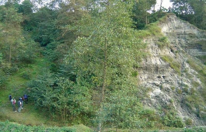
ການພັນລະນາ:
A combination of measures, implemented by a group of neighbouring families, is used to address landslips, gully formation and stream bank erosion problems in the middle hills of Nepal. All these processes affect the stability of adjacent agricultural land and cause problems downstream. Small-scale farming is dominant in the area surrounding the treated land - which theoretically belongs to the government but is used by these families.
This pilot technological package is proving suitable in Nepal for steep/very steep slopes under subhumid climates within an altitudinal range of 1,000-1,500 m a.s.l. This type of intervention, combined with the active involvement of stakeholders (who contribute three quarters of the cost), was recently introduced to Nepal under a watershed management programme, co-funded by the European Commission (see related approach ‘Integrated watershed management’).
Initially, ditches with bunds on the lower side are constructed along the contour. Within the gullies and along the stream banks, cement bags (filled with cement, brick chips, sand and/or earth) are placed to avoid deepening of the channel. Wattle fences, made from woven bamboo are also used as checks in the gullies. These structures are complemented by vegetative measures: Nepalese alder (Alnus nepalensis), bamboo (Dendrocalamus sp.), cardamom (Elettaria cardamomum), and broom grass (Thyosonaelana maxima) are planted. These species establish quickly in degraded sites and also control erosion, stabilise land and serve as cash crops, and for fodder, fuelwood and timber. Alder (locally called utis) is a nitrogen-fixing multipurpose tree which helps restore soil fertility.
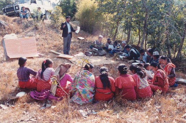
Farmers can get economic benefits within a few years from these plants. Another advantage of this package is that the vegetative resources needed are locally available and cheap. Furthermore farmers already know how to propagate them. Maintenance costs are negligible. Once established, the stabilised and revegetated sites provide improved environments for birds and insects – thus favouring biodiversity - and they help protect natural springs. In this case study, the economic returns from the cash crops mainly go to one family. Another few families also utilise this site, extracting common products (fodder, litter, timber) for domestic use. Additionally, the location is regularly used as an unofficial demonstration site, being visited by various people (farmers, SWC specialists) interested in the technology. This represents an indirect benefit to a larger number of people and strengthens institutions at household and community levels.
2.3 ຮູບພາບຂອງເຕັກໂນໂລຢີ
ສື່ຮູບພາບ
2.5 ປະເທດ / ເຂດ / ສະຖານທີ່ບ່ອນທີ່ ເຕັກໂນໂລຢີ ໄດ້ຮັບການນໍາໃຊ້ ແລະ ທີ່ຖືກປົກຄຸມດ້ວຍການປະເມີນຜົນ
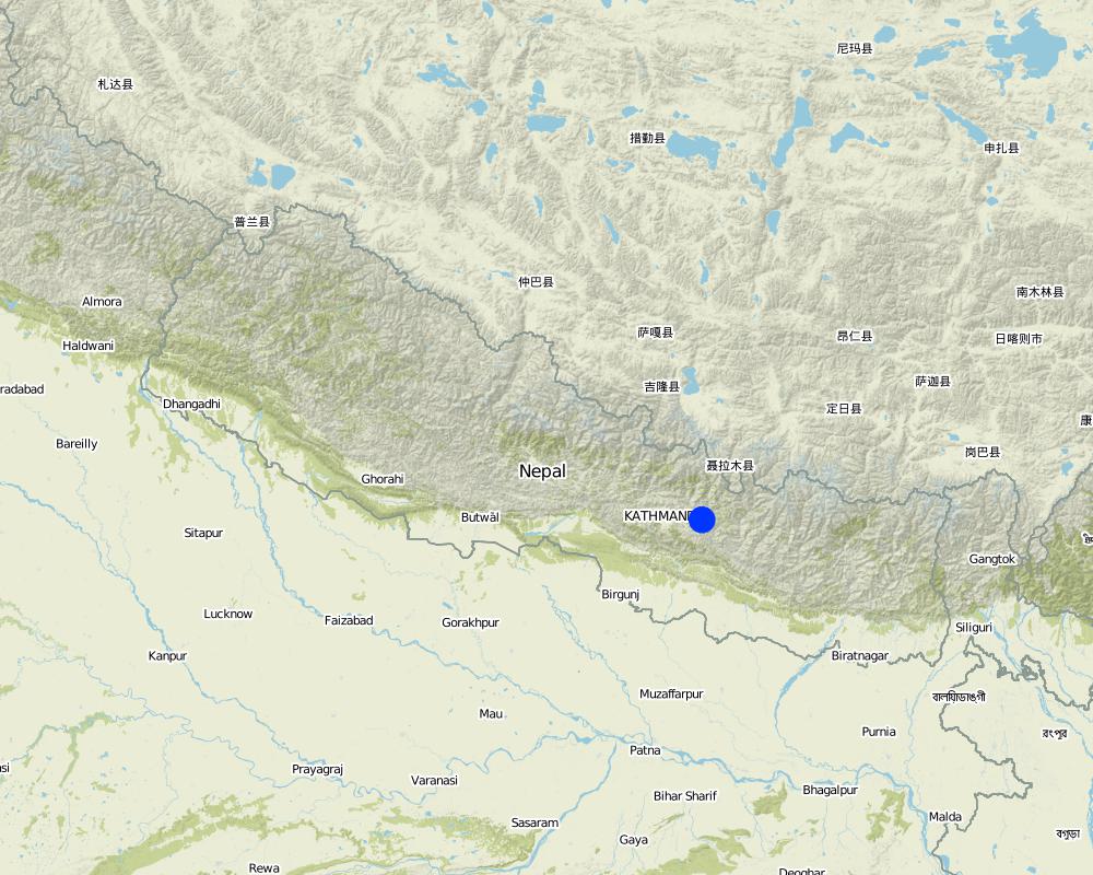
ປະເທດ:
ເນໂປ
ພາກພື້ນ / ລັດ / ແຂວງ:
Kathmandu
ຂໍ້ມູນເພີ່ມເຕີມຂອງສະຖານທີ່:
Kathmandu/Bagmati watershed
ໃຫ້ລະບຸ ການແຜ່ຂະຫຍາຍ ເຕັກໂນໂລຢີ:
- ແຜ່ຂະຫຍາຍຢ່າງໄວວາໃນພື້ນທີ່
ຖ້າຫາກວ່າເຕັກໂນໂລຢີ ໄດ້ກະຈາຍໄປທົ່ວພື້ນທີ່, ໃຫ້ລະບຸເນື້ອທີ່ ທີ່ຖືກປົກຄຸມ (ເປັນ ກິໂລຕາແມັດ):
0.14
ຖ້າຫາກບໍ່ຮູ້ເນື້ອທີ່ທີ່ແນ່ນອນ, ໃຫ້ລະບຸ ເນື້ອທີ່ໂດຍປະມານ ທີ່ໃກ້ຄຽງ:
- 0.1-1 ກມ 2
ຄວາມຄິດເຫັນ:
Total area covered by the SLM Technology is 0.14 km2.
The Approach covered a bigger area. This is just one example.
Map
×2.6 ວັນທີໃນການຈັດຕັ້ງປະຕິບັດ
ຖ້າຫາກວ່າ ບໍ່ຮູ້ຈັກ ປີທີ່ຊັດເຈນ ແມ່ນໃຫ້ປະມານ ວັນທີເອົາ:
- ຫຼາຍກ່ອນ 50 ປີຜ່ານມາ (ແບບພື້ນບ້ານ)
2.7 ການນໍາສະເໜີ ເຕັກໂນໂລຢີ
ໃຫ້ລະບຸ ເຕັກໂນໂລຢີ ໄດ້ຖືກຈັດຕັ້ງປະຕິບັດຄືແນວໃດ?
- ໂດຍຜ່ານໂຄງການ / ການຊ່ວຍເຫຼືອຈາກພາຍນອກ
3. ການໃຈ້ແຍກ ເຕັກໂນໂລຢີ ໃນການຄຸ້ມຄອງ ດິນແບບຍືນຍົງ
3.1 ຈຸດປະສົງຫຼັກ (ຫຼາຍ) ຂອງເຕັກໂນໂລຢີ
- ຫຼຸດຜ່ອນ, ປ້ອງກັນ, ຟື້ນຟູ ການເຊື່ອມໂຊມຂອງດິນ
3.2 ປະເພດການນໍາໃຊ້ທີ່ດິນ ໃນປະຈຸບັນ() ທີ່ເຕັກໂນໂລຢີ ໄດ້ຖືກນໍາໃຊ້
ການນຳໃຊ້ທີ່ດິນ ປະສົມພາຍໃນພື້ນທີ່ດຽວກັນ:
ແມ່ນ
ລະບຸການນຳໃຊ້ທີ່ດິນແບບປະສົມ (ຜົນລະປູກ / ທົ່ງຫຍ້າລ້ຽງສັດ / ຕົ້ນໄມ້):
- ປ່າໄມ້-ທົ່ງຫຍ້າ

ທົ່ງຫຍ້າລ້ຽງສັດ

ປ່າໄມ້ / ປ່າ
ປະເພດຂອງຕົ້ນໄມ້:
- ໄມ້ໄຜ່
- Nepalese Alder (Alnus nepalensis)

ດິນ ທີ່ບໍ່ອຸດົມສົມບູນ
ລະບຸ ຊະນິດ:
Wasteland (degraded shrubland before SWC)
ຂໍ້ສັງເກດ:
degraded , no annual crops, occasionally grazed
ຄວາມຄິດເຫັນ:
Major cash crop: Nepalese Alder (Alnus nepalensis), Bamboo (Dendroc) and broom grass (Thysanolaena maxima)
Major land use problems (compiler’s opinion): - concentrated runoff from upstream agricultural areas
- landslides, gullies and stream bank erosion
- gullies back-cutting into fertile agricultural land and threatening irrigation canals and homesteads
Major land use problems (land users’ perception): Landslide and gully erosion due to poor vegetative cover (steepness and lack of effective drainage/ diversion system).
Future (final) land use (after implementation of SLM Technology): Mixed: Ma: Agro-silvopastoralism
Constraints of wastelands (degraded shrubland) (before SWC) (degraded , no annual crops, occasionally grazed)
Number of growing seasons per year: 2
Longest growing period in days: 180 Longest growing period from month to month: Jun - Nov
3.4 ການສະໜອງນ້ຳ
ການສະໜອງນໍ້າ ໃນພື້ນທີ່ ທີ່ໄດ້ນໍາໃຊ້ ເຕັກໂນໂລຢີ:
- ນໍ້າຝົນ
3.5 ການນໍາໃຊ້ເຕັກໂນໂລຢີ ທີ່ຢູ່ໃນກຸ່ມການຄຸ້ມຄອງ ທີ່ດິນແບບຍືນຍົງ
- ມາດຕະການ ຕັດຂວາງ ກັບຄວາມຄ້ອຍຊັນ
- ຫຼຸດຜ່ອນຄວາມສ່ຽງ ທາງໄພພິບັດ ບົນພື້ນຖານລະບົບນິເວດ
3.6 ມາດຕະການ ການຄຸ້ມຄອງ ທີ່ດິນແບບຍືນຍົງ ປະກອບດ້ວຍ ເຕັກໂນໂລຢີ

ມາດຕະການ ທາງດ້ານພືດພັນ
- V1: ເປັນໄມ້ຢືນຕົ້ນ ແລະ ການປົກຫຸ້ມຂອງໄມ້ພຸ່ມ

ມາດຕະການໂຄງສ້າງ
- S2: ຄັນຄຸ, ແຄມຕາຝັ່ງ
3.7 ປະເພດດິນເຊື່ອມໂຊມ ຫຼັກທີ່ໄດ້ນໍາໃຊ້ ເຕັກໂນໂລຢີ

ດິນເຊາະເຈື່ອນ ໂດຍນໍ້າ
- Wg: ການເຊາະເຈື່ອນຮ່ອງນ້ຳ / ຫ້ວຍ
- Wm: ການເຄື່ອນຍ້າຍອິນຊີວັດຖຸ / ດິນເຈື່ອນ
- Wr: ແຄມຕາຝັ່ງເຈື່ອນ

ການເຊື່ອມໂຊມ ຂອງດິນ ທາງເຄມີ
- Cn: ຄວາມອຸດົມສົມບູນ ລົດໜ້ອຍຖອຍລົງ ແລະ ສານອິນຊີວັດຖຸລົດລົງ (ບໍ່ແມ່ນສາເຫດມາຈາກການເຊາະເຈື່ອນ)
ຄວາມຄິດເຫັນ:
Main causes of degradation: deforestation / removal of natural vegetation (incl. forest fires), education, access to knowledge and support services (lack of knowledge)
3.8 ການປ້ອງກັນ, ການຫຼຸດຜ່ອນ, ຫຼືການຟື້ນຟູຂອງການເຊື່ອມໂຊມຂອງດິນ
ໃຫ້ລະບຸ ເປົ້າໝາຍ ເຕັກໂນໂລຢີ ທີ່ພົວພັນ ກັບຄວາມເຊື່ອມໂຊມຂອງດິນ:
- ປ້ອງກັນການເຊື່ອມໂຊມຂອງດິນ
- ຫຼຸດຜ່ອນການເຊື່ອມໂຊມຂອງດິນ
ຄວາມຄິດເຫັນ:
Secondary goals: rehabilitation / reclamation of denuded land
4. ຂໍ້ກໍາໜົດ, ກິດຈະກໍາການປະຕິບັດ, ວັດຖຸດິບ, ແລະຄ່າໃຊ້ຈ່າຍ
4.1 ເຕັກນິກ ໃນການແຕ້ມແຜນວາດ ເຕັກໂນໂລຢີ
ຄຸນລັກສະນະ ຂອງເຕັກນິກ (ທີ່ກ່ຽວຂ້ອງ ກັບການແຕ້ມແຜນວາດ ທາງດ້ານເຕັກນີກ):
Land slip and stream bank protection: an overview of the multiple and integrated vegetative and structural measures: cut-off drain
1. landslip area
2. banana trees
3. alder trees
4. bamboo wattle fences
5. cardamom
6. planting bamboo
7. cement bag check dams
8. broom grass
9. cutting bamboo
10. stream bank
11. agricultural fi elds in a fl at area
Insert 1: Bamboo wattle fence
combined with retention ditch and
grassed bund to stabilise steep slopes and gullies.
Insert 2: Old cement bags fi lled to
form checks in gullies
Technical knowledge required for field staff / advisors: high
Technical knowledge required for land users: high
Main technical functions: control of concentrated runoff: impede / retard, reduction of slope angle, reduction of slope length, improvement of ground cover, stabilisation of soil
Secondary technical functions: control of concentrated runoff: drain / divert, increase of infiltration, introduction of cash crop
Scattered / dispersed
Vegetative material: T : trees / shrubs, F : fruit trees / shrubs, C : perennial crops, G : grass
Vertical interval within rows / strips / blocks (m): 2 m
Trees/ shrubs species: Alnus nepalenses
Fruit trees / shrubs species: Dendrocalamus sp.
Perennial crops species: Large cardamom
Grass species: Broom grass
Diversion ditch/ drainage
Spacing between structures (m): 10 m
Depth of ditches/pits/dams (m): 0.25 m
Width of ditches/pits/dams (m): 0.1 m
Length of ditches/pits/dams (m): 10 m
Terrace: forward sloping
Spacing between structures (m): 10 m
Structural measure: sediment sand / trap
Vertical interval between structures (m): 1-4 m
Spacing between structures (m): 0.3 m
Depth of ditches/pits/dams (m): 3-4 m
Width of ditches/pits/dams (m): 0.8 m
Structural measure: cement bags
Structural measure: wattle fences
Construction material (concrete): Sand/cement .
Construction material (other): Bamboo culm cutting (1.5 m long)
Slope (which determines the spacing indicated above): 100%
If the original slope has changed as a result of the Technology, the slope today is: 15%
Vegetation is used for stabilisation of structures.
ຜູ້ຂຽນ:
Mats Gurtner
4.2 ຂໍ້ມູນທົ່ວໄປກ່ຽວກັບການຄິດໄລ່ປັດໃຈຂາເຂົ້າໃນການຜະລິດ ແລະ ມູນຄ່າອື່ນໆ
ລະບຸ ວິທີການ ຄຳໃຊ້ຈ່າຍ ແລະ ປັດໄຈນໍາເຂົ້າ ທີ່ໄດ້ຄິດໄລ່:
- ຕໍ່ພື້ນທີ່ ທີ່ໄດ້ຈັດຕັ້ງປະຕິບັດ ເຕັກໂນໂລຢີ
ໃຫ້ລະບຸຫົວໜ່ວຍ ຂະໜາດ ແລະ ເນື້ອທີ່:
1.4 ha
ລະບຸ ສະກຸນເງິນທີ່ໃຊ້ສໍາລັບ ການຄິດໄລ່ຄ່າໃຊ້ຈ່າຍ:
- USA
ລະບຸ ຄ່າຈ້າງ ຄ່າແຮງງານສະເລ່ຍ ຕໍ່ ວັນ:
1.35
4.3 ການສ້າງຕັ້ງກິດຈະກໍາ
| ກິດຈະກໍາ | Timing (season) | |
|---|---|---|
| 1. | Preparing site for implementation of vegetative measures | June |
| 2. | Planting of alder (Alnus nepalensis,), cardamom (Elettaria cardamomum), | July - August |
| 3. | Watering of new plants using buckets | Mar- May (1st year) |
| 4. | Application of farmyard manure at time of planting | Time of planting and every December |
| 5. | Weeding | January |
| 6. | Earthing up new plants with soil | January |
| 7. | Construction of contour bunds and ditches | January–April |
| 8. | Stabilisation of slopes using bamboo wattle fences, and gullies using the check dams | |
| 9. | Gully stabilisation as walls of cement bags are placed across the gullies and along stream banks | June |
| 10. | Preparing the site for planting | June |
4.4 ຕົ້ນທຶນ ແລະ ປັດໄຈຂາເຂົ້າທີ່ຈໍາເປັນໃນຈັດຕັ້ງປະຕິບັດ
| ລະບຸ ປັດໃຈ ນໍາເຂົ້າ ໃນການຜະລີດ | ຫົວໜ່ວຍ | ປະລິມານ | ຕົ້ນທຶນ ຕໍ່ຫົວໜ່ວຍ | ຕົ້ນທຶນທັງໝົດ ຂອງປັດໃຈຂາເຂົ້າ ໃນການຜະລິດ | % ຂອງຕົ້ນທຶນທັງໝົດ ທີ່ຜູ້ນໍາໃຊ້ທີ່ດິນ ໃຊ້ຈ່າຍເອງ | |
|---|---|---|---|---|---|---|
| ແຮງງານ | Stabilisation of gully and vegetative measures | Persons/day | 1567.0 | 1.35 | 2115.45 | 75.0 |
| ອຸປະກອນ | Tools | ha | 1.0 | 55.0 | 55.0 | 100.0 |
| ອຸປະກອນ | Empty cement bags | pieces | 600.0 | 0.0166666 | 10.0 | |
| ວັດສະດຸໃນການປູກ | Bamboo cuttings | pieces | 600.0 | 0.9416666 | 565.0 | 50.0 |
| ຝຸ່ນ ແລະ ຢາຊີວະພາບ | Compost / manure | ha | 1.0 | 10.0 | 10.0 | 10.0 |
| ວັດສະດຸກໍ່ສ້າງ | Cement bags filled | pieces | 30.0 | 4.166666 | 125.0 | |
| ວັດສະດຸກໍ່ສ້າງ | Alder saplings | pieces | 2500.0 | 0.016 | 40.0 | 100.0 |
| ວັດສະດຸກໍ່ສ້າງ | Seedlings cardamon | pieces | 400.0 | 0.0125 | 5.0 | |
| ຕົ້ນທຶນທັງໝົດ ໃນການຈັດຕັ້ງປະຕິບັດ ເຕັກໂນໂລຢີ | 2925.45 | |||||
| ຄ່າໃຊ້ຈ່າຍທັງໝົດ ສຳລັບການສ້າງຕັ້ງເຕັກໂນໂລຢີ ເປັນສະກຸນເງີນໂດລາ | 2925.45 | |||||
ຖ້າຫາກຜູ້ນຳໃຊ້ທີ່ດິນ ນຳໃຊ້ມູນຄ່າຕ່ຳກວ່າ 100% ໃຫ້ລະບຸ ແມ່ນໃຜເປັນຜູ້ຊ່ວຍ ໃນລາຍຈ່າຍທີ່ເຫຼືອ:
By different stakeholders
ຄວາມຄິດເຫັນ:
Duration of establishment phase: 12 month(s)
4.5 ບໍາລຸງຮັກສາ / ແຜນຈັດຕັ້ງປະຕິບັດ ກິດຈະກໍາ
| ກິດຈະກໍາ | ໄລຍະເວລາ / ຄວາມຖີ່ | |
|---|---|---|
| 1. | Apply farmyard manure | January /1 |
| 2. | Weed | January /1 |
| 3. | Prepare land for further planting of large cardamom and broom grass | March-April /1 |
| 4. | Thin cardamom, bamboo, alder, broom grass with a knife: | May,June /1 |
| 5. | Replant cardamom, broom grass, bamboo that did not establish | June,July /1 |
| 6. | Earth up | Aug-Sep and January /1 |
| 7. | Prune alders | December.,January /1 |
4.6 ຄ່າໃຊ້ຈ່າຍ ແລະ ປັດໄຈນໍາເຂົ້າທີ່ຈໍາເປັນສໍາລັບການບໍາລຸງຮັກສາກິດຈະກໍາ / ແຜນປະຕິບັດ (ຕໍ່ປີ)
| ລະບຸ ປັດໃຈ ນໍາເຂົ້າ ໃນການຜະລີດ | ຫົວໜ່ວຍ | ປະລິມານ | ຕົ້ນທຶນ ຕໍ່ຫົວໜ່ວຍ | ຕົ້ນທຶນທັງໝົດ ຂອງປັດໃຈຂາເຂົ້າ ໃນການຜະລິດ | % ຂອງຕົ້ນທຶນທັງໝົດ ທີ່ຜູ້ນໍາໃຊ້ທີ່ດິນ ໃຊ້ຈ່າຍເອງ | |
|---|---|---|---|---|---|---|
| ແຮງງານ | Maintaining plants | Persons/day | 41.0 | 1.35 | 55.35 | 100.0 |
| ອຸປະກອນ | Tools | ha | 1.0 | 10.0 | 10.0 | 100.0 |
| ວັດສະດຸໃນການປູກ | Compost / manure | ha | 1.0 | 5.0 | 5.0 | 100.0 |
| ຕົ້ນທຶນທັງໝົດ ທີ່ໃຊ້ໃນການບໍາລຸງຮັກສາ ເຕັກໂນໂລຢີ | 70.35 | |||||
| ຄ່າໃຊ້ຈ່າຍທັງໝົດ ສຳລັບການບົວລະບັດຮກສາເຕັກໂນໂລຢີ ເປັນສະກຸນເງີນໂດລາ | 70.35 | |||||
ຄວາມຄິດເຫັນ:
Machinery/ tools: Activities are carried out manually using local and traditional tools:
The costs (per ha) are calculated for the entire SWC site (consisting of 1.4 ha) including all establishment and maintenance inputs. Labour costs: information based on oral information by farmer. Estimate was approx. 3 people per working day over 2 years.
4.7 ປັດໄຈ ທີ່ສໍາຄັນ ທີ່ສົ່ງຜົນກະທົບ ຕໍ່ຄ່າໃຊ້ຈ່າຍ
ໃຫ້ອະທິບາຍ ປັດໃຈ ທີ່ສົ່ງຜົນກະທົບ ຕໍ່ຕົ້ນທຶນ ໃນການຈັດຕັ້ງປະຕິບັດ:
labour is the major input.
5. ສະພາບແວດລ້ອມທໍາມະຊາດ ແລະ ມະນຸດ
5.1 ອາກາດ
ປະລິມານນໍ້າຝົນປະຈໍາປີ
- < 250 ມີລິແມັດ
- 251-500 ມີລິແມັດ
- 501-750 ມີລິແມັດ
- 751-1,000 ມີລິແມັດ
- 1,001-1,500 ມີລິແມັດ
- 1,501-2,000 ມີລິແມັດ
- 2,001-3,000 ມີລິແມັດ
- 3,001-4,000 ມີລິແມັດ
- > 4,000 ມີລິແມັດ
ເຂດສະພາບອາກາດກະສິກໍາ
- ຄວາມຊຸ່ມ
Thermal climate class: subtropics
5.2 ພູມິປະເທດ
ຄ່າສະເລ່ຍ ຄວາມຄ້ອຍຊັນ:
- ພື້ນທີ່ຮາບພຽງ (0-2%)
- ອ່ອນ (3-5 %)
- ປານກາງ (6-10 %)
- ມ້ວນ (11-15 %)
- ເນີນ(16-30%)
- ໍຊັນ (31-60%)
- ຊັນຫຼາຍ (>60%)
ຮູບແບບຂອງດິນ:
- ພູພຽງ / ທົ່ງພຽງ
- ສັນພູ
- ເປີ້ນພູ
- ເນີນພູ
- ຕີນພູ
- ຮ່ອມພູ
ເຂດລະດັບສູງ:
- 0-100 ແມັດ a.s.l.
- 101-500 ແມັດ a.s.l.
- 501-1,000 ແມັດ a.s.l.
- 1,001-1,500 ແມັດ a.s.l.
- 1,501-2,000 ແມັດ a.s.l.
- 2,001-2,500 ແມັດ a.s.l.
- 2,501-3,000 ແມັດ a.s.l.
- 3,001-4,000 ແມັດ a.s.l.
- > 4,000 ແມັດ a.s.l.
ຄຳເຫັນ ແລະ ຂໍ້ມູນສະເພາະ ເພີ່ມເຕີມ ກ່ຽວກັບ ພູມີປະເທດ:
Slopes on average: Also hilly
5.3 ດິນ
ຄວາມເລິກ ຂອງດິນສະເລ່ຍ:
- ຕື້ນຫຼາຍ (0-20 ຊັງຕີແມັດ)
- ຕື້ນ (21-50 ຊຕມ)
- ເລີກປານກາງ (51-80 ຊຕມ)
- ເລິກ (81-120 ຊມ)
- ເລິກຫຼາຍ (> 120 cm)
ເນື້ອດິນ (ໜ້າດິນ):
- ຫຍາບ / ເບົາ (ດິນຊາຍ)
- ປານກາງ (ດິນໜຽວ, ດິນໂຄນ)
ຊັ້ນອິນຊີວັດຖຸ ເທິງໜ້າດິນ:
- ປານກາງ (1-3 %)
ຖ້າເປັນໄປໄດ້ ແມ່ນໃຫ້ຕິດຄັດ ການພັນລະນາດິນ ຫຼື ຂໍ້ມູນສະເພາະຂອງດິນ, ຕົວຢ່າງ, ຄຸນລັກສະນະ ປະເພດຂອງດິນ, ຄ່າຄວາມເປັນກົດ / ເປັນດ່າງຂອງດິນ, ສານອາຫານ, ດິນເຄັມ ແລະ ອື່ນໆ.
Soil fertility is low (sandy) - medium (loam)
Soil drainage / infiltration is medium
Soil water storage capacity is low
5.6 ຄຸນລັກສະນະ ຂອງຜູ້ນໍາໃຊ້ທີ່ດິນ ທີ່ໄດ້ນໍາໃຊ້ເຕັກໂນໂລຢີ
ລະບົບ ການຕະຫຼາດ ແລະ ຜົນຜະລິດ:
- ກຸ້ມຕົນເອງ (ພໍພຽງ)
- ປະສົມປົນເປ( ກຸ້ມຕົນເອງ/ເປັນສິນຄ້າ)
ລາຍຮັບ ທີ່ບໍ່ໄດ້ມາຈາກ ການຜະລິດ ກະສິກໍາ:
- 10-50 % ຂອງລາຍຮັບທັງໝົດ
ລະດັບຄວາມຮັ່ງມີ:
- ສະເລ່ຍ
ລະດັບ ການຫັນເປັນກົນຈັກ:
- ການໃຊ້ແຮງງານຄົນ
ໃຫ້ລະບຸ ຄຸນລັກສະນະ ຂອງຜູ້ນໍາໃຊ້ທີ່ດິນ:
Population density: 200-500 persons/km2
Annual population growth: 2% - 3%
2% of the land users are very rich and own 40% of the land.
5% of the land users are rich and own 30% of the land.
85% of the land users are average wealthy and own 15% of the land.
3% of the land users are poor and own 10% of the land.
3% of the land users are poor and own 5% of the land.
Off-farm income specification: Off-farm activities: occasionally teaching at farmer's school; selling non-timber forest products on the market; some people workin markets/shops/onconstruction, sites, and similar ..
5.7 ເນື້ອທີ່ສະເລ່ຍຂອງດິນ ທີ່ຜູ້ນຳໃຊ້ທີ່ດິນ ໃຊ້ເຮັດເຕັກໂນໂລຢີ
- <0.5 ເຮັກຕາ
- 0.5-1 ເຮັກຕາ
- 1-2 ເຮັກຕາ
- 2-5 ເຮັກຕາ
- 5-15 ເຮັກຕາ
- 15-50 ເຮັກຕາ
- 50-100 ເຮັກຕາ
- 100-500 ເຮັກຕາ
- 500-1,000 ເຮັກຕາ
- 1,000-10,000 ເຮັກຕາ
- > 10,000 ເຮັກຕາ
5.8 ເຈົ້າຂອງທີ່ດິນ, ສິດໃຊ້ທີ່ດິນ, ແລະ ສິດທິການນໍາໃຊ້ນໍ້າ
ເຈົ້າຂອງດິນ:
- ລັດ
ສິດທິ ໃນການນໍາໃຊ້ທີ່ດິນ:
- ເປີດກວ້າງ (ບໍ່ມີການຈັດຕັ້ງ)
6. ຜົນກະທົບ ແລະ ລາຍງານສະຫຼຸບ
6.1 ການສະແດງຜົນກະທົບ ພາຍໃນພື້ນທີ່ ທີ່ໄດ້ຈັດຕັ້ງປະຕິບັດ ເຕັກໂນໂລຢີ
ຜົນກະທົບທາງເສດຖະກິດສັງຄົມ
ການຜະລິດ
ການຜະລິດອາຫານສັດ
ຄຸນນະພາບຂອງອາຫານສັດ
ຜົນຜະລິດໄມ້
ຄວາມຄິດເຫັນ / ລະບຸແຈ້ງ:
including fuel wood
ລາຍໄດ້ ແລະ ຄ່າໃຊ້ຈ່າຍ
ລາຍຮັບ ຈາກການຜະລີດ
ຄວາມຄິດເຫັນ / ລະບຸແຈ້ງ:
cash crop introduction
ມີວຽກໜັກ
ຄວາມຄິດເຫັນ / ລະບຸແຈ້ງ:
high during establishment, low during maintenance
ຜົນກະທົບທາງດ້ານເສດຖະກິດສັງຄົມອື່ນໆ
input constraints
ຄວາມຄິດເຫັນ / ລະບຸແຈ້ງ:
high during establishment, low during maintenance
input constraints for maintenance
ຜົນກະທົບດ້ານວັດທະນາທໍາສັງຄົມ
ສະພາບທາງດ້ານສຸຂະພາບ
ຄວາມຄິດເຫັນ / ລະບຸແຈ້ງ:
due to cardamom’s medicinal properties
ສະຖາບັນ ການຈັດຕັ້ງຊຸມຊົນ
ຄວາມຄິດເຫັນ / ລະບຸແຈ້ງ:
by way of community resource mobilisation (e.g. as a result of common establishment activities; visits to the site by outsiders)
ສະຖາບັນແຫ່ງຊາດ
ຄວາມຮູ້ກ່ຽວກັບ ການຄຸ້ມຄອງ ທີ່ດິນແບບຍືນຍົງ / ການເຊື່ອມໂຊມຂອງດິນ
ການຫຼຸດຜ່ອນ ຂໍ້ຂັດແຍ່ງ
ຄວາມຄິດເຫັນ / ລະບຸແຈ້ງ:
especially in case of insecure land tenureship
Illegal extract of non-timber forest products
ຄວາມຄິດເຫັນ / ລະບຸແຈ້ງ:
because of remoteness
ຜົນກະທົບຕໍ່ລະບົບນິເວດ
ວົງຈອນນໍ້າ / ນໍ້າ
ການໄຫຼ ຂອງນໍ້າໜ້າດິນ
ປະລິມານ ກ່ອນການຈັດຕັ້ງປະຕິບັດ ການຄຸ້ມຄອງ ທີ່ດິນແບບຍືນຍົງ:
80 m3/ha/y
ປະລີມານ ຫຼັງການຈັດຕັ້ງປະຕິບັດ ການຄຸ້ມຄອງ ທີ່ດິນແບບຍືນຍົງ:
35 m3/ha/y
ການລະບາຍນໍ້າ
ດິນ
ຄວາມຊຸ່ມຂອງດິນ
ການປົກຄຸມຂອງດິນ
ການສູນເສຍດິນ
ປະລິມານ ກ່ອນການຈັດຕັ້ງປະຕິບັດ ການຄຸ້ມຄອງ ທີ່ດິນແບບຍືນຍົງ:
200 t/ha/y
ປະລີມານ ຫຼັງການຈັດຕັ້ງປະຕິບັດ ການຄຸ້ມຄອງ ທີ່ດິນແບບຍືນຍົງ:
10 t/ha/yr
ຜົນກະທົບຕໍ່ລະບົບນິເວດອື່ນໆ
soil erosion and sediment transport(locally)
ຄວາມຄິດເຫັນ / ລະບຸແຈ້ງ:
soil erosion increase and increased sediment transport locally during establishment of structural measures (construction of wattle fences, terraces, cement bag walls in gullies)
6.2 ຜົນກະທົບທາງອ້ອມ ຈາກການນໍາໃຊ້ເຕັກໂນໂລຢີ
ການໄຫຼຂອງນໍ້າໃນລະດູແລ້ງ
ນໍ້າຖ້ວມຢູ່ເຂດລຸ່ມນໍ້າ
ການທັບຖົມ ຂອງດິນຕະກອນ ຢູ່ເຂດລຸ່ມນໍ້າ
ມົນລະພິດ ທາງນໍ້າ / ນໍ້າໄຕ້ດິນ
stabilisation of upstream agricultural land
ຄວາມຄິດເຫັນ / ລະບຸແຈ້ງ:
The agricultural land which is located on the upper portion of the SWC area is stabilised
runoff/transported sediments
grazing pressure
ຄວາມຄິດເຫັນ / ລະບຸແຈ້ງ:
grazing pressure will increase on another site because of the SWC site is closed for grazing
6.3 ການປ້ອງກັນ ແລະ ຄວາມບອບບາງ ຂອງເຕັກໂນໂລຢິ ໃນການປ່ຽນແປງສະພາບດິນຟ້າອາກາດ ແລະ ກ່ຽວຂ້ອງກັບອາກາດທີ່ມີການປ່ຽນແປງທີ່ຮຸນແຮງ / ໄພພິບັດທາງທໍາມະຊາດ (ຮັບຮູ້ໄດ້ໂດຍຜູ້ນໍາໃຊ້ທີ່ດິນ)
ການປ່ຽນແປງດິນຟ້າອາກາດ ເທື່ອລະກ້າວ
ການປ່ຽນແປງດິນຟ້າອາກາດ ເທື່ອລະກ້າວ
| ລະດູການ | ເພີ່ມຂື້ນ ຫຼື ຫຼຸດລົງ | ການນໍາໃຊ້ ເຕັກໂນໂລຢີ ສາມາດ ຮັບມື ໄດ້ຄືແນວໃດ? | |
|---|---|---|---|
| ອຸນຫະພູມປະຈໍາປີ | ເພີ່ມຂື້ນ | ດີ |
ອາກາດ ທີ່ກ່ຽວພັນກັບຄວາມຮຸນແຮງ (ໄພພິບັດທາງທໍາມະຊາດ)
ໄພພິບັດທາງອຸຕຸນິຍົມ
| ການນໍາໃຊ້ ເຕັກໂນໂລຢີ ສາມາດ ຮັບມື ໄດ້ຄືແນວໃດ? | |
|---|---|
| ພະຍຸຝົນ | ບໍ່ດີ |
| ພາຍຸລົມທ້ອງຖິ່ນ | ດີ |
ໄພພິບັດທາງພູມອາກາດ
| ການນໍາໃຊ້ ເຕັກໂນໂລຢີ ສາມາດ ຮັບມື ໄດ້ຄືແນວໃດ? | |
|---|---|
| ແຫ້ງແລ້ງ | ດີ |
ໄພພິບັດທາງອຸທົກກະສາກ
| ການນໍາໃຊ້ ເຕັກໂນໂລຢີ ສາມາດ ຮັບມື ໄດ້ຄືແນວໃດ? | |
|---|---|
| ໂດຍທົ່ວໄປ (ແມ່ນໍ້າ) ນໍ້າຖ້ວມ | ບໍ່ດີ |
ຜົນສະທ້ອນສະພາບອາກາດອື່ນໆທີ່ກ່ຽວຂ້ອງ
ຜົນສະທ້ອນສະພາບອາກາດອື່ນໆທີ່ກ່ຽວຂ້ອງ
| ການນໍາໃຊ້ ເຕັກໂນໂລຢີ ສາມາດ ຮັບມື ໄດ້ຄືແນວໃດ? | |
|---|---|
| ໄລຍະເວລາການຂະຫຍາຍຕົວຫຼຸດລົງ | ດີ |
6.4 ການວິເຄາະຕົ້ນທຶນ ແລະ ຜົນປະໂຫຍດ
ຈະເຮັດປະໂຫຍດເພື່ອປຽບທຽບກັບຄ່າໃຊ້ຈ່າຍກັບສິ່ງກໍ່ສ້າງ (ຈາກທັດສະນະຂອງຜູ້ນຳໃຊ້ທີ່ດິນ) ໄດ້ແນວໃດ?
ຜົນຕອບແທນ ໃນໄລຍະສັ້ນ:
ຜົນກະທົບທາງລົບ
ຜົນຕອບແທນ ໃນໄລຍະຍາວ:
ຜົນກະທົບທາງບວກຫຼາຍ
ຈະໄດ້ຮັບຜົນປະໂຫຍດເມື່ອປຽບທຽບກັບ / ຄ່າໃຊ້ຈ່າຍໃນການບຳລຸງຮັກສາທີເ່ກີດຂື້ນອິກ (ຈາກທັດສະນະຄະຕິຂອງຜູ້ນຳໃຊ້ທີ່ດິນ) ໄດ້ແນວໃດ?
ຜົນຕອບແທນ ໃນໄລຍະສັ້ນ:
ຜົນກະທົບທາງບວກ
ຜົນຕອບແທນ ໃນໄລຍະຍາວ:
ຜົນກະທົບທາງບວກຫຼາຍ
6.5 ການປັບຕົວຮັບເອົາເຕັກໂນໂລຢີ
- > 50%
ຖ້າຫາກວ່າມີ, ປະລິມານ (ຈໍານວນຂອງຄົວເຮືອນ / ເນື້ອທີ່ການຄຸ້ມຄອງ):
38 households in an area of 1.4 ha
ທັງໝົດນັ້ນ ແມ່ນໃຜ ໄດ້ປັບຕົວເຂົ້າ ໃນການນໍາໃຊ້ ເຕັກໂນໂລຢີ, ມີຈັກຄົນ ທີ່ສາມາດເຮັດເອງໄດ້, ຕົວຢ່າງ, ປາດສະຈາກ ການຊ່ວຍເຫຼືອ ທາງດ້ານອຸປະກອນ / ການຈ່າຍເປັນເງິນ?
- 51-90%
ຄວາມຄິດເຫັນ:
47% of land user families have adopted the Technology with external material support
18 land user families have adopted the Technology with external material support
Comments on acceptance with external material support: survey results
53% of land user families have adopted the Technology without any external material support
20 land user families have adopted the Technology without any external material support
Comments on spontaneous adoption: survey results
There is a moderate trend towards spontaneous adoption of the Technology
Comments on adoption trend: estimates by the authors, based on the past trends of adoption.
6.7 ຈຸດແຂງ / ຂໍ້ດີ / ໂອກາດ ໃນການນໍາໃຊ້ ເຕັກໂນໂລຢີ
| ຈຸດແຂງ / ຂໍ້ດີ / ໂອກາດໃນການນໍາໃຊ້ທີ່ດິນ |
|---|
|
Family members have learnt the technology. it is easy to replicate. How can they be sustained / enhanced? Provide training and schooling to farmers to spread this information to others (eg through village initiatives supported by government). |
|
Better environment, increased biodiversity How can they be sustained / enhanced? As above |
|
Soil and water conservation How can they be sustained / enhanced? As above |
|
Fresh products, health benefits from cardamom How can they be sustained / enhanced? As above |
|
Income generation from cash cropping of cardamom, bamboo, broom grass) How can they be sustained / enhanced? As above |
| ຈຸດແຂງ / ຈຸດດີ / ໂອກາດ ຈາກທັດສະນະຂອງຜູ້ປ້ອນຂໍ້ມູນ ຫຼື ບຸກຄົນສຳຄັນ |
|---|
|
The technology requires resources which are largely locally available and of low costs. How can they be sustained / enhanced? Raise awareness that landslide threatened stream banks and steep slops can be protected using local resources. |
|
Technology addresses livelihood constraints How can they be sustained / enhanced? Raise awareness that the technology is profitable. |
6.8 ຈຸດອ່ອນ / ຂໍ້ເສຍ / ຄວາມສ່ຽງ ໃນການນໍາໃຊ້ ເຕັກໂນໂລຢີ ແລະ ວິທີການແກ້ໄຂບັນຫາ
| ຈຸດອ່ອນ/ຂໍ້ບົກຜ່ອງ/ຄວາມສ່ຽງ ຈາກທັດສະນະຂອງຜູ້ປ້ອນຂໍ້ມູນ ຫຼື ບຸກຄົນສຳຄັນ | ມີວິທີການແກ້ໄຂຄືແນວໃດ? |
|---|---|
| The technology is adopted more by better ressourced farmers | Government programmes should seek to involve poor farmers in land development with incentives for adopting recommennded technologies |
| Establishment costs are high | Subsidise the cost (extension service, projects), reduce establishment costs by designing alternative structural measures without use of cement. |
| Socio-economic conflicts can arise when the value of land is raised | Take equity issues into account when implementing such a programme, and spread the benefits. |
| Establishment is very labour intensive. |
7. ເອກະສານອ້າງອີງ ແລະ ການເຊື່ອມຕໍ່
7.1 ວິທີການ / ແຫຼ່ງຂໍ້ມູນ
7.2 ເອກກະສານອ້າງອີງທີ່ເປັນບົດລາຍງານ
ຫົວຂໍ້, ຜູ້ຂຽນ, ປີ, ISBN:
IBIWMP (2003) Engineering Field Manual. Kathmandu: Government of Nepal, Department of Soil Conservation and Watershed Management Programme,Bagmati Integrated Watershed Management
ຫົວຂໍ້, ຜູ້ຂຽນ, ປີ, ISBN:
Howell, J. (ed) (1999) Roadside Bio-engineering Reference Manual. Kathmandu: Government of Nepal, Department of Roads
ຂໍ້ມູນການເຊື່ອມຕໍ່ ແລະ ເນື້ອໃນ
ຂະຫຍາຍທັງໝົດ ຍຸບທັງໝົດການເຊື່ອມຕໍ່
Integrated watershed management for landslip and stream bank … [ເນໂປ]
Integrated watershed management as an example for landslip and stream bank stabilisation based on fostering a partnership between community institutions, line agencies, district authorities and consultants
- ຜູ້ສັງລວມຂໍ້ມູນ: Dileep Kumar Karna
ເນື້ອໃນ
ບໍ່ມີເນື້ອໃນ