
Gully Rehabilitation with Native Trees [Tajikistan]
- Creation:
- Update:
- Compiler: Selina Studer
- Editor: –
- Reviewers: David Streiff, Alexandra Gavilano
technologies_1543 - Tajikistan
View sections
Expand all Collapse all1. General information
1.2 Contact details of resource persons and institutions involved in the assessment and documentation of the Technology
land user:
Mirsoiv Iskandar
Tajikistan
land user:
Mirsoiv Avaz
Tajikistan
SLM specialist:
SLM specialist:
Boev Jahonbek
NCCR
Tajikistan
SLM specialist:
Name of the institution(s) which facilitated the documentation/ evaluation of the Technology (if relevant)
NCCR North-South (NCCR North-South) - KyrgyzstanName of the institution(s) which facilitated the documentation/ evaluation of the Technology (if relevant)
Tajik Soil Insitute (Tajik Soil Institute) - TajikistanName of the institution(s) which facilitated the documentation/ evaluation of the Technology (if relevant)
CDE Centre for Development and Environment (CDE Centre for Development and Environment) - Switzerland1.3 Conditions regarding the use of data documented through WOCAT
The compiler and key resource person(s) accept the conditions regarding the use of data documented through WOCAT:
Yes
2. Description of the SLM Technology
2.1 Short description of the Technology
Definition of the Technology:
Vegetative and structural technology for the rehabilitation of an expanded gully
2.2 Detailed description of the Technology
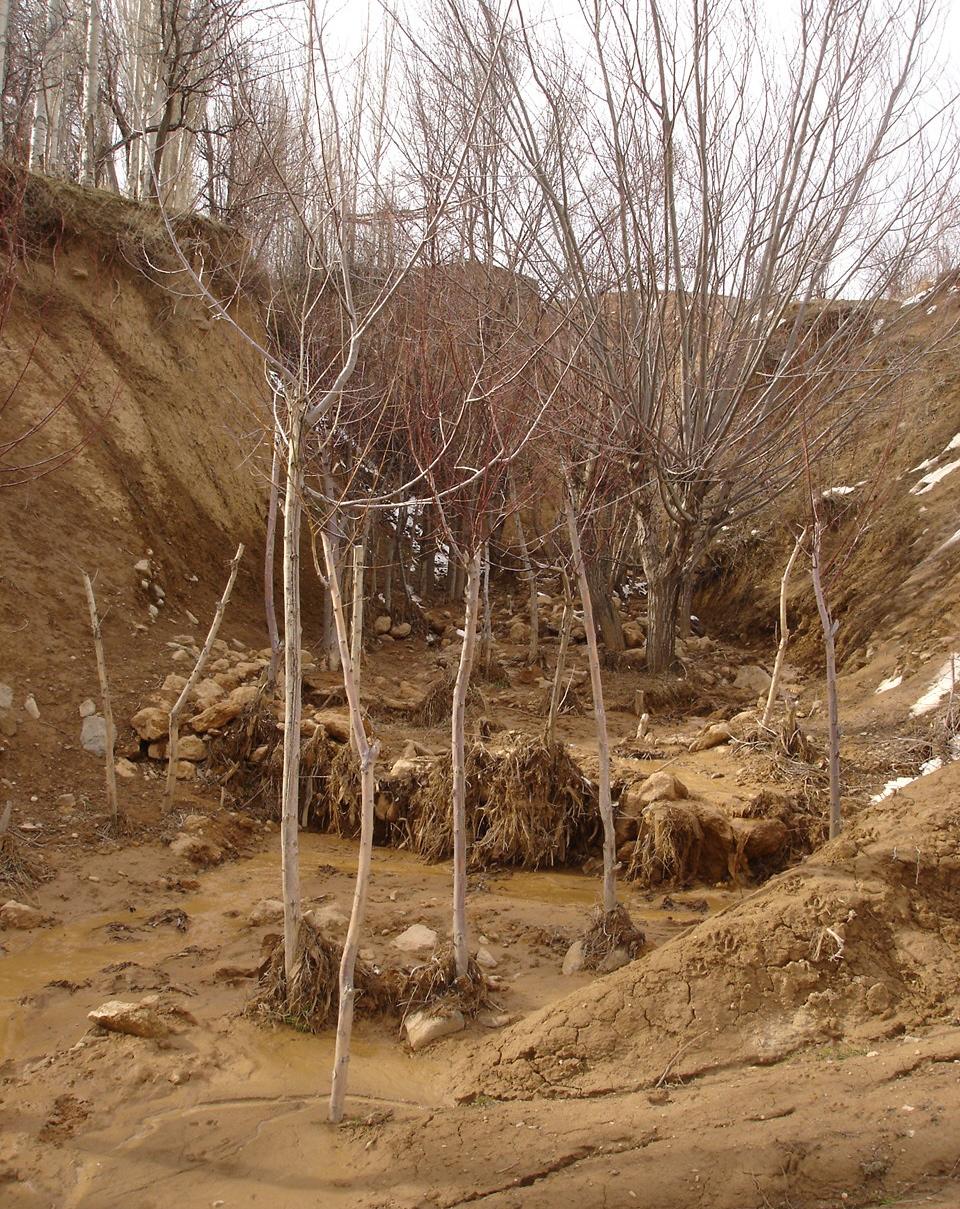
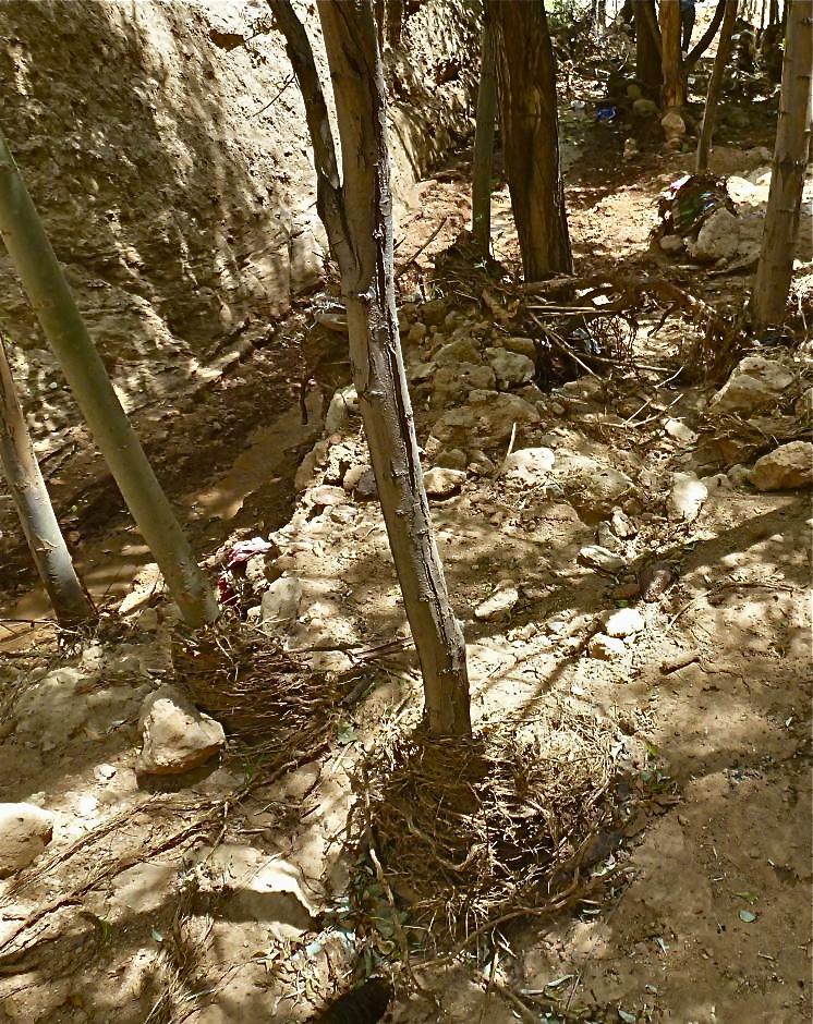
Description:
The extension of a deep incised gully, which borders a fertile orchard, is stopped and sediments are trapped by the help of vegetative and structural measures. The gully floor is vegetated with different trees inter alia willow, poplar, cherry, blackberry and walnut which are arranged in random groups. At the bottom of the gully where it intersects the road there is a stonewall, which collects the sediments that are washed down during heavy rainfalls mostly in spring. A dense bush line with Russian olives, apricots, cherries, walnuts, plums and buxus has been planted on the top of the side slopes of the gully, and roots of those bushes keep the soil stable and at the same time they prevent landslides and expansion of the gully. These tree lines are cut from time to time, otherwise they grow and become heavy and due to their weight the trees would possibly fall into the gully.
Purpose of the Technology: (1) The deep roots of willow trees on the bottom of the gully protect the soil and prevent it from being eroded during the heavy spring floods. Trees also help to collect sediment and to accumulate it in the gully. (2) The dense bush lines with its deep roots, on the top of the gully slope, stop the horizontal erosion, which endangers the fertile orchard close to the gully. (3) A stonewall at the lower end of the gully collects sediments which have been washed down. Once in a while a heightening of the stonewall has to be done. The technology with its three measures prevents from further gully expansion and supports its rehabilitation.
Establishment / maintenance activities and inputs: These three measures, the tree line, the bottom vegetation and the stonewall were developed and implemented by the farmer's own initiative. The farmer implemented the technology on his own and expands it every year. The entire technology doesn’t have to be established at once, which allows investing money and time whenever it is available. For maintenance new trees are planted both in the gully and in the tree line, which has to be cut and pruned from time to time. The technology is relatively affordable and facile to implement. At the beginning the farmer bought some seedlings. Meanwhile, the plants reproduce themselves and the farmer doesn't have to buy seedlings for further maintenance. The stones can be collected for free in the nearby riverbed. The work is done manually; no special tools are needed for the technology.
Natural / human environment: The farmer is proud of the outcome of his initiative. However he wishes that his neighbours would follow his lead, as for them it would be beneficial to implement the technology as well. He stated that usually people do not listen to a common farmer, but if the technology would be introduced by an official person it would spread out quickly.
2.3 Photos of the Technology
Media Gallery
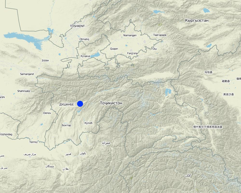
2.5 Country/ region/ locations where the Technology has been applied and which are covered by this assessment
Country:
Tajikistan
Region/ State/ Province:
Tajikistan
Further specification of location:
Faizabad, Javonon, Chinoro
Comments:
Boundary points of the Technology area: northernmost: 38°36'00.09"/69°23'58.93"
southernmost: 38°35'54.77"/69°24'03.18"
Comments:
Total area covered by the SLM Technology is 0.002138 m2.
Map
×2.6 Date of implementation
If precise year is not known, indicate approximate date:
- 10-50 years ago
2.7 Introduction of the Technology
Specify how the Technology was introduced:
- through land users' innovation
Comments (type of project, etc.):
The farmer implemented the technology during the civil war and teached other farmers to do it. But it is not so easy for the farmer to convince other people to follow his example.
3. Classification of the SLM Technology
3.1 Main purpose(s) of the Technology
- reduce, prevent, restore land degradation
- protect a watershed/ downstream areas – in combination with other Technologies
3.2 Current land use type(s) where the Technology is applied

Unproductive land
Specify:
gully
Remarks:
The gully floor is vegetated with different trees inter alia willow, poplar, cherry, blackberry and walnut which are arranged in random groups.
A dense bush line with Russian olives, apricots, cherries, walnuts, plums and buxus has been planted on the top of the side slopes of the gully.
Comments:
Major land use problems (compiler’s opinion): Highly erodible loess soil, and heavy rainfalls which causes a lot of surface runoff and erosion.
Major land use problems (land users’ perception): Lack of water for irrigation, too few rain, steep slopes, infertile soils which make the use of fertilizers essential.
Constraints of wastelands / deserts / glaciers / swamps
Number of growing seasons per year:
1
Specify:
Longest growing period in days: 210Longest growing period from month to month: March to August
3.5 SLM group to which the Technology belongs
- cross-slope measure
- surface water management (spring, river, lakes, sea)
3.6 SLM measures comprising the Technology

vegetative measures
- V1: Tree and shrub cover

structural measures
- S6: Walls, barriers, palisades, fences
Comments:
Main measures: vegetative measures
Secondary measures: structural measures
Type of vegetative measures: aligned: -along boundary, scattered / dispersed
3.7 Main types of land degradation addressed by the Technology

soil erosion by water
- Wg: gully erosion/ gullying
- Wm: mass movements/ landslides
- Wr: riverbank erosion
Comments:
Main type of degradation addressed: Wg: gully erosion / gullying
Secondary types of degradation addressed: Wm: mass movements / landslides, Wr: riverbank erosion
Main causes of degradation: soil management (lack of knowledge for soil treatement, e.g. people dig hollows which support gully formation, agronoms from soviet times are missing), over-exploitation of vegetation for domestic use (Trees were cut for domestic use), overgrazing, disturbance of water cycle (infiltration / runoff), Heavy / extreme rainfall (intensity/amounts), land tenure (land is not private property), poverty / wealth (no money for tractors, fertilizers, education, etc.,), education, access to knowledge and support services, war and conflicts (during the civil war the land was not cultivated sustainably), governance / institutional (land use rights)
Secondary causes of degradation: deforestation / removal of natural vegetation (incl. forest fires), change in temperature (too hot and too cold temperatures dry out the soil, plants cannot survive), change of seasonal rainfall, population pressure, inputs and infrastructure: (roads, markets, distribution of water points, other, …) (lack of machinery to treat the field properly)
3.8 Prevention, reduction, or restoration of land degradation
Specify the goal of the Technology with regard to land degradation:
- prevent land degradation
- restore/ rehabilitate severely degraded land
Comments:
Main goals: prevention of land degradation, rehabilitation / reclamation of denuded land
4. Technical specifications, implementation activities, inputs, and costs
4.1 Technical drawing of the Technology
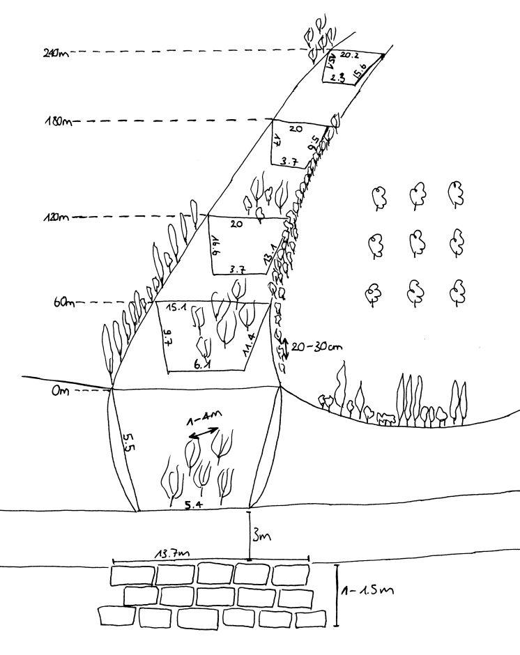
Technical specifications (related to technical drawing):
The technology includes three different sketch information; 1) dense tree lines on the top of the side slopes, 2) stonewall at the end of the gully and 3) willow trees at the bottom of the gully.
Location: Chinoro. Faizabad/Javonon/Tajikistan
Date: 03.09.2012
Technical knowledge required for field staff / advisors: high (People do not accept a suggestion if it is not from a good educated, accepted person.)
Technical knowledge required for land users: low
Main technical functions: control of concentrated runoff: impede / retard, increase of surface roughness, stabilisation of soil (eg by tree roots against land slides)
Secondary technical functions: control of concentrated runoff: retain / trap, improvement of ground cover, sediment retention / trapping, sediment harvesting, reduction in wind speed, increase of biomass (quantity), promotion of vegetation species and varieties (quality, eg palatable fodder)
Aligned: -contour
Vegetative material: T : trees / shrubs
Aligned: -along boundary
Vegetative material: T : trees / shrubs
Vertical interval within rows / strips / blocks (m): 0.2-0.4
Width within rows / strips / blocks (m): 2m (1-2 Row(s))
Scattered / dispersed
Vegetative material: T : trees / shrubs
Vertical interval within rows / strips / blocks (m): 1-4
Trees/ shrubs species: russian olive, willow tree, acacia, poplar, box
Fruit trees / shrubs species: walnut, apple, apricot, plum, cherries
Wall/ barrier
Vertical interval between structures (m): 0
Spacing between structures (m): 0
Depth of ditches/pits/dams (m): 1.5
Width of ditches/pits/dams (m): 3
Length of ditches/pits/dams (m): 13.7
Construction material (stone): Are taken from a nearby riverbed.
Author:
Selina Studer
4.2 General information regarding the calculation of inputs and costs
other/ national currency (specify):
Tajik Somoni
If relevant, indicate exchange rate from USD to local currency (e.g. 1 USD = 79.9 Brazilian Real): 1 USD =:
4.7
Indicate average wage cost of hired labour per day:
12.00
4.3 Establishment activities
| Activity | Timing (season) | |
|---|---|---|
| 1. | plant trees in the gully | whole year |
| 2. | plant tree line | whole year |
| 3. | build wall |
4.4 Costs and inputs needed for establishment
| Specify input | Unit | Quantity | Costs per Unit | Total costs per input | % of costs borne by land users | |
|---|---|---|---|---|---|---|
| Labour | Build wall | wall | 1.0 | 125.0 | 125.0 | 100.0 |
| Labour | Planting trees | Persons/day | 3.0 | 12.0 | 36.0 | 100.0 |
| Plant material | Tree seedlings | 1.0 | 166.0 | 166.0 | ||
| Total costs for establishment of the Technology | 327.0 | |||||
| Total costs for establishment of the Technology in USD | 69.57 | |||||
4.5 Maintenance/ recurrent activities
| Activity | Timing/ frequency | |
|---|---|---|
| 1. | add trees in the gully | spring |
| 2. | add trees in the tree line | spring |
| 3. | increase the height of the stonewall | once a while |
4.6 Costs and inputs needed for maintenance/ recurrent activities (per year)
| Specify input | Unit | Quantity | Costs per Unit | Total costs per input | % of costs borne by land users | |
|---|---|---|---|---|---|---|
| Labour | Add trees | Persons/day | 1.0 | 12.0 | 12.0 | 100.0 |
| Labour | Increase the hight of the wall | - | ||||
| Total costs for maintenance of the Technology | 12.0 | |||||
| Total costs for maintenance of the Technology in USD | 2.55 | |||||
Comments:
The fact that the inputs for the technology are not evenly distributed throughout the area, the costs were calculated for the whole technology area.
4.7 Most important factors affecting the costs
Describe the most determinate factors affecting the costs:
The material is relatively affordable. Money intensive factor are the seedlings during establishment phase. Following years the trees reproduce themselves. The establishment of the technology, the planting of the trees and the building of the stonewall require a lot of labour input in the initial phase. As the whole technology does not have to be implemented at once, the work can be split-up over years.
5. Natural and human environment
5.1 Climate
Annual rainfall
- < 250 mm
- 251-500 mm
- 501-750 mm
- 751-1,000 mm
- 1,001-1,500 mm
- 1,501-2,000 mm
- 2,001-3,000 mm
- 3,001-4,000 mm
- > 4,000 mm
Agro-climatic zone
- semi-arid
Thermal climate class: temperate
5.2 Topography
Slopes on average:
- flat (0-2%)
- gentle (3-5%)
- moderate (6-10%)
- rolling (11-15%)
- hilly (16-30%)
- steep (31-60%)
- very steep (>60%)
Landforms:
- plateau/plains
- ridges
- mountain slopes
- hill slopes
- footslopes
- valley floors
Altitudinal zone:
- 0-100 m a.s.l.
- 101-500 m a.s.l.
- 501-1,000 m a.s.l.
- 1,001-1,500 m a.s.l.
- 1,501-2,000 m a.s.l.
- 2,001-2,500 m a.s.l.
- 2,501-3,000 m a.s.l.
- 3,001-4,000 m a.s.l.
- > 4,000 m a.s.l.
5.3 Soils
Soil depth on average:
- very shallow (0-20 cm)
- shallow (21-50 cm)
- moderately deep (51-80 cm)
- deep (81-120 cm)
- very deep (> 120 cm)
Soil texture (topsoil):
- coarse/ light (sandy)
Topsoil organic matter:
- medium (1-3%)
- low (<1%)
If available, attach full soil description or specify the available information, e.g. soil type, soil PH/ acidity, Cation Exchange Capacity, nitrogen, salinity etc.
Soil depth on average: No soil in the gully
Soil fertility is medium for the treeline on top of the slopes of the gully (close to the orchard). but in the gully its very low because the soil was washed away.
Topsoil organic matter is medium at the treeline on top of the gully slope.
Soil drainage / infiltration is medium and in the orchard, gully works as drainage
Soil water storage capacity is very low
5.4 Water availability and quality
Ground water table:
> 50 m
Availability of surface water:
poor/ none
Water quality (untreated):
good drinking water
5.5 Biodiversity
Species diversity:
- low
5.6 Characteristics of land users applying the Technology
Off-farm income:
- less than 10% of all income
Relative level of wealth:
- poor
- average
Individuals or groups:
- individual/ household
Gender:
- men
Indicate other relevant characteristics of the land users:
Land users applying the Technology are mainly common / average land users
Difference in the involvement of women and men: The technology was directed by the farmer and implemented by the farmer's son. Only men were involved in the technology. In Tajikistan usually work for men and women is strictly divided. Women work in the household, take care for children and work on the field. The gully rehabilitation project was men's work.
Population density: 100-200 persons/km2
Annual population growth: 2% - 3%
10% of the land users are rich (trader which buy and sell products from the farmers).
60% of the land users are average wealthy and own 80% of the land.
30% of the land users are poor and own 20% of the land.
Off-farm income specification: beneath the technology the farmer has an orchard with intercropping, a flax and a wheat plot.
5.7 Average area of land used by land users applying the Technology
- < 0.5 ha
- 0.5-1 ha
- 1-2 ha
- 2-5 ha
- 5-15 ha
- 15-50 ha
- 50-100 ha
- 100-500 ha
- 500-1,000 ha
- 1,000-10,000 ha
- > 10,000 ha
Is this considered small-, medium- or large-scale (referring to local context)?
- small-scale
5.8 Land ownership, land use rights, and water use rights
Land ownership:
- state
Land use rights:
- open access (unorganized)
Water use rights:
- communal (organized)
5.9 Access to services and infrastructure
health:
- poor
- moderate
- good
education:
- poor
- moderate
- good
technical assistance:
- poor
- moderate
- good
employment (e.g. off-farm):
- poor
- moderate
- good
markets:
- poor
- moderate
- good
energy:
- poor
- moderate
- good
roads and transport:
- poor
- moderate
- good
drinking water and sanitation:
- poor
- moderate
- good
financial services:
- poor
- moderate
- good
6. Impacts and concluding statements
6.1 On-site impacts the Technology has shown
Socio-economic impacts
Production
wood production
production area
Income and costs
expenses on agricultural inputs
Comments/ specify:
Especially at the time of establishment.
Socio-cultural impacts
SLM/ land degradation knowledge
Comments/ specify:
Land users acquired new knowledge.
security to have fertile land
Ecological impacts
Water cycle/ runoff
surface runoff
Soil
soil cover
soil loss
Biodiversity: vegetation, animals
biomass/ above ground C
plant diversity
animal diversity
beneficial species
habitat diversity
Climate and disaster risk reduction
wind velocity
Comments/ specify:
Treeline
6.2 Off-site impacts the Technology has shown
downstream flooding
downstream siltation
6.3 Exposure and sensitivity of the Technology to gradual climate change and climate-related extremes/ disasters (as perceived by land users)
Gradual climate change
Gradual climate change
| Season | increase or decrease | How does the Technology cope with it? | |
|---|---|---|---|
| annual temperature | increase | not known |
Climate-related extremes (disasters)
Meteorological disasters
| How does the Technology cope with it? | |
|---|---|
| local rainstorm | not well |
| local windstorm | well |
Climatological disasters
| How does the Technology cope with it? | |
|---|---|
| drought | not well |
Other climate-related consequences
Other climate-related consequences
| How does the Technology cope with it? | |
|---|---|
| reduced growing period | not well |
Comments:
On the bottom of the gully willow trees should be planted which have strong roots to resist floods, especially if the gully is already deep. At the slopes Russian olives and wild cherries can be planted. The higher amount of trees makes gully even more stable.
6.4 Cost-benefit analysis
How do the benefits compare with the establishment costs (from land users’ perspective)?
Short-term returns:
neutral/ balanced
Long-term returns:
very positive
How do the benefits compare with the maintenance/ recurrent costs (from land users' perspective)?
Short-term returns:
positive
Long-term returns:
very positive
Comments:
Much more extra work comes up for the establishment, but for the farmer work is not a disadvantage.
6.5 Adoption of the Technology
Comments:
There is a little trend towards spontaneous adoption of the Technology
6.7 Strengths/ advantages/ opportunities of the Technology
| Strengths/ advantages/ opportunities in the land user’s view |
|---|
|
Stopping the expansion (prevention) of the gully and filling up the gully (rehabilitation). How can they be sustained / enhanced? Maintain the vegetative measures, plant more seedlings and let them reproduce themselves. |
|
Firewood and construction material production. How can they be sustained / enhanced? Increase the vegetation with wood of good quality and use it in a sustainable manner (cut only as much as will be reproduced). |
| Strengths/ advantages/ opportunities in the compiler’s or other key resource person’s view |
|---|
|
Extensive use of the area and a relatively rich diversity of local vegetation. The maintained gully provides new habitat for natural flora and fauna. How can they be sustained / enhanced? Keep and promote the diversity of plants in the gully. |
|
Cheap and relatively less labor intensive work. Relatively little knowledge and no special tools are required. How can they be sustained / enhanced? Make the technology public. |
| The entire technology doesn’t have to be established at once, which allows investing money and time whenever it is available. |
6.8 Weaknesses/ disadvantages/ risks of the Technology and ways of overcoming them
| Weaknesses/ disadvantages/ risks in the land user’s view | How can they be overcome? |
|---|---|
| The trees stop the water, sediments, branches etc. too effectively and this creates problems with too much water in the gully, which is washing out the sides of the gully. |
| Weaknesses/ disadvantages/ risks in the compiler’s or other key resource person’s view | How can they be overcome? |
|---|---|
| A disadvantage is the extra work the farmer have to spend on a little productive area. | In the land users view work is not a disadvantage, it is his job. Considering the fact that it is not that much extra work, it is not a big disadvantage. |
| For the establishment a first investment for the seedlings is required. | An establishment of the technology during a longer period allows to grow own seedlings from the plants which do not cost anything. |
7. References and links
7.1 Methods/ sources of information
7.2 References to available publications
Title, author, year, ISBN:
Integrated spatial assessment for Sustainable Land Management „SLM-planning“ in the loess hill of central Tajikistan using WOCAT mapping tools (working title), Selina Studer, 2013, Master Thesis, University of Bern, Bern.
Available from where? Costs?
University of Bern
7.3 Links to relevant online information
Title/ description:
WOCAT technology movie: Orchard-Based Agroforestry
URL:
wocat@cde.ch
Links and modules
Expand all Collapse allLinks
No links
Modules
No modules