
Gully Rehabilitation with Native Trees [ทาจิกิสถาน]
- ผู้สร้างสรรค์:
- การอัพเดท:
- ผู้รวบรวม: Selina Studer
- ผู้เรียบเรียง: –
- ผู้ตรวจสอบ: David Streiff, Alexandra Gavilano
technologies_1543 - ทาจิกิสถาน
ดูส่วนย่อย
ขยายทั้งหมด ย่อทั้งหมด1. ข้อมูลทั่วไป
1.2 รายละเอียดที่ติดต่อได้ของผู้รวบรวมและองค์กรที่เกี่ยวข้องในการประเมินและการจัดเตรียมทำเอกสารของเทคโนโลยี
ผู้ใช้ที่ดิน:
Mirsoiv Iskandar
ทาจิกิสถาน
ผู้ใช้ที่ดิน:
Mirsoiv Avaz
ทาจิกิสถาน
ผู้เชี่ยวชาญ SLM:
ผู้เชี่ยวชาญ SLM:
Boev Jahonbek
NCCR
ทาจิกิสถาน
ผู้เชี่ยวชาญ SLM:
ชื่อขององค์กรซึ่งอำนวยความสะดวกในการทำเอกสารหรือการประเมินเทคโนโลยี (ถ้าเกี่ยวข้อง)
NCCR North-South (NCCR North-South) - คีร์กีซสถานชื่อขององค์กรซึ่งอำนวยความสะดวกในการทำเอกสารหรือการประเมินเทคโนโลยี (ถ้าเกี่ยวข้อง)
Tajik Soil Insitute (Tajik Soil Institute) - ทาจิกิสถานชื่อขององค์กรซึ่งอำนวยความสะดวกในการทำเอกสารหรือการประเมินเทคโนโลยี (ถ้าเกี่ยวข้อง)
CDE Centre for Development and Environment (CDE Centre for Development and Environment) - สวิตเซอร์แลนด์1.3 เงื่อนไขการใช้ข้อมูลที่ได้บันทึกผ่านทาง WOCAT
ผู้รวบรวมและวิทยากรหลักยอมรับเงื่อนไขเกี่ยวกับการใช้ข้อมูลที่ถูกบันทึกผ่านทาง WOCAT:
ใช่
2. การอธิบายลักษณะของเทคโนโลยี SLM
2.1 การอธิบายแบบสั้น ๆ ของเทคโนโลยี
คำจำกัดความของเทคโนโลยี:
Vegetative and structural technology for the rehabilitation of an expanded gully
2.2 การอธิบายแบบละเอียดของเทคโนโลยี
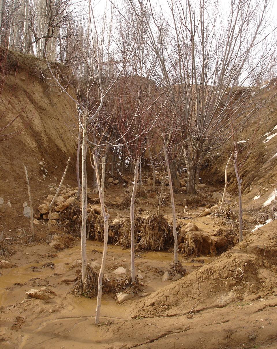
คำอธิบาย:
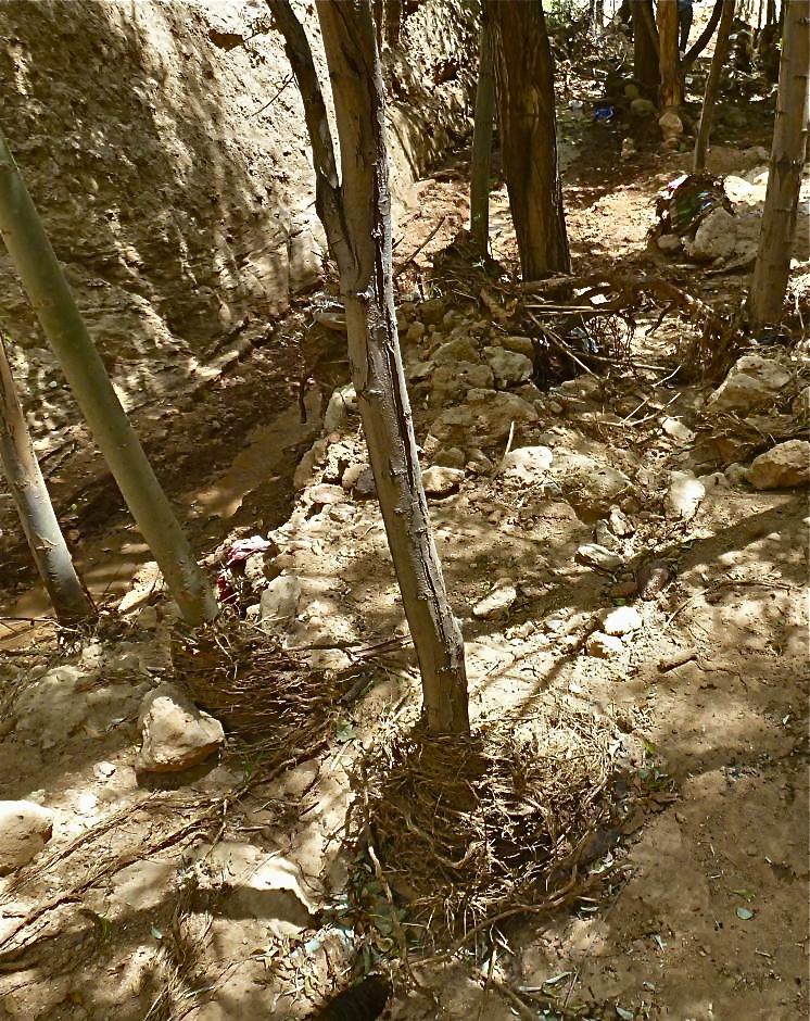
The extension of a deep incised gully, which borders a fertile orchard, is stopped and sediments are trapped by the help of vegetative and structural measures. The gully floor is vegetated with different trees inter alia willow, poplar, cherry, blackberry and walnut which are arranged in random groups. At the bottom of the gully where it intersects the road there is a stonewall, which collects the sediments that are washed down during heavy rainfalls mostly in spring. A dense bush line with Russian olives, apricots, cherries, walnuts, plums and buxus has been planted on the top of the side slopes of the gully, and roots of those bushes keep the soil stable and at the same time they prevent landslides and expansion of the gully. These tree lines are cut from time to time, otherwise they grow and become heavy and due to their weight the trees would possibly fall into the gully.
Purpose of the Technology: (1) The deep roots of willow trees on the bottom of the gully protect the soil and prevent it from being eroded during the heavy spring floods. Trees also help to collect sediment and to accumulate it in the gully. (2) The dense bush lines with its deep roots, on the top of the gully slope, stop the horizontal erosion, which endangers the fertile orchard close to the gully. (3) A stonewall at the lower end of the gully collects sediments which have been washed down. Once in a while a heightening of the stonewall has to be done. The technology with its three measures prevents from further gully expansion and supports its rehabilitation.
Establishment / maintenance activities and inputs: These three measures, the tree line, the bottom vegetation and the stonewall were developed and implemented by the farmer's own initiative. The farmer implemented the technology on his own and expands it every year. The entire technology doesn’t have to be established at once, which allows investing money and time whenever it is available. For maintenance new trees are planted both in the gully and in the tree line, which has to be cut and pruned from time to time. The technology is relatively affordable and facile to implement. At the beginning the farmer bought some seedlings. Meanwhile, the plants reproduce themselves and the farmer doesn't have to buy seedlings for further maintenance. The stones can be collected for free in the nearby riverbed. The work is done manually; no special tools are needed for the technology.
Natural / human environment: The farmer is proud of the outcome of his initiative. However he wishes that his neighbours would follow his lead, as for them it would be beneficial to implement the technology as well. He stated that usually people do not listen to a common farmer, but if the technology would be introduced by an official person it would spread out quickly.
2.3 รูปภาพของเทคโนโลยี
อัลบั้มสื่อบันทึก
2.5 ประเทศภูมิภาค หรือสถานที่ตั้งที่เทคโนโลยีได้นำไปใช้และได้รับการครอบคลุมโดยการประเมินนี้
ประเทศ:
ทาจิกิสถาน
ภูมิภาค/รัฐ/จังหวัด:
Tajikistan
ข้อมูลจำเพาะเพิ่มเติมของสถานที่ตั้ง :
Faizabad, Javonon, Chinoro
แสดงความคิดเห็น:
Boundary points of the Technology area: northernmost: 38°36'00.09"/69°23'58.93"
southernmost: 38°35'54.77"/69°24'03.18"
Comments:
Total area covered by the SLM Technology is 0.002138 m2.
Map
×2.6 วันที่การดำเนินการ
ถ้าไม่รู้ปีที่แน่นอน ให้ระบุวันที่โดยประมาณ:
- 10-50 ปี
2.7 คำแนะนำของเทคโนโลยี
ให้ระบุว่าเทคโนโลยีถูกแนะนำเข้ามาอย่างไร:
- ด้วยการริเริ่มของผู้ใช้ที่ดินเอง
ความคิดเห็น (ประเภทของโครงการ เป็นต้น) :
The farmer implemented the technology during the civil war and teached other farmers to do it. But it is not so easy for the farmer to convince other people to follow his example.
3. การจัดประเภทของเทคโนโลยี SLM
3.1 วัตถุประสงค์หลักของเทคโนโลยี
- ลด ป้องกัน ฟื้นฟู การเสื่อมโทรมของที่ดิน
- ป้องกันพื้นที่ลุ่มน้ำ/บริเวณท้ายน้ำ โดยร่วมกับเทคโนโลยีอื่นๆ
3.2 ประเภทของการใช้ที่ดินในปัจจุบันที่ได้นำเทคโนโลยีไปใช้

ที่ดินที่ไม่ให้ผลผลิต
ระบุ:
gully
ข้อสังเกต:
The gully floor is vegetated with different trees inter alia willow, poplar, cherry, blackberry and walnut which are arranged in random groups.
A dense bush line with Russian olives, apricots, cherries, walnuts, plums and buxus has been planted on the top of the side slopes of the gully.
แสดงความคิดเห็น:
Major land use problems (compiler’s opinion): Highly erodible loess soil, and heavy rainfalls which causes a lot of surface runoff and erosion.
Major land use problems (land users’ perception): Lack of water for irrigation, too few rain, steep slopes, infertile soils which make the use of fertilizers essential.
Constraints of wastelands / deserts / glaciers / swamps
Number of growing seasons per year:
1
Specify:
Longest growing period in days: 210Longest growing period from month to month: March to August
3.5 กลุ่ม SLM ที่ตรงกับเทคโนโลยีนี้
- มาตรการปลูกพืชขวางความลาดชัน (cross-slope measure)
- การจัดการน้ำผิวดิน (น้ำพุ แม่น้ำทะเลสาบ ทะเล)
3.6 มาตรการ SLM ที่ประกอบกันเป็นเทคโนโลยี

มาตรการอนุรักษ์ด้วยวิธีพืช
- V1: ต้นไม้และพุ่มไม้คลุมดิน

มาตรการอนุรักษ์ด้วยโครงสร้าง
- S6: กำแพง สิ่งกีดขวาง รั้วไม้ รั้วต่างๆ
แสดงความคิดเห็น:
Main measures: vegetative measures
Secondary measures: structural measures
Type of vegetative measures: aligned: -along boundary, scattered / dispersed
3.7 รูปแบบหลักของการเสื่อมโทรมของที่ดินที่ได้รับการแก้ไขโดยเทคโนโลยี

การกัดกร่อนของดินโดยน้ำ
- Wg (Gully erosion): การกัดกร่อนแบบร่องธารหรือการทำให้เกิดร่องน้ำเซาะ
- Wm (Mass movement): การเคลื่อนตัวของมวลดินหรือดินถล่ม
- Wr (Riverbank erosion): การกัดกร่อนริมฝั่งแม่น้ำ
แสดงความคิดเห็น:
Main type of degradation addressed: Wg: gully erosion / gullying
Secondary types of degradation addressed: Wm: mass movements / landslides, Wr: riverbank erosion
Main causes of degradation: soil management (lack of knowledge for soil treatement, e.g. people dig hollows which support gully formation, agronoms from soviet times are missing), over-exploitation of vegetation for domestic use (Trees were cut for domestic use), overgrazing, disturbance of water cycle (infiltration / runoff), Heavy / extreme rainfall (intensity/amounts), land tenure (land is not private property), poverty / wealth (no money for tractors, fertilizers, education, etc.,), education, access to knowledge and support services, war and conflicts (during the civil war the land was not cultivated sustainably), governance / institutional (land use rights)
Secondary causes of degradation: deforestation / removal of natural vegetation (incl. forest fires), change in temperature (too hot and too cold temperatures dry out the soil, plants cannot survive), change of seasonal rainfall, population pressure, inputs and infrastructure: (roads, markets, distribution of water points, other, …) (lack of machinery to treat the field properly)
3.8 การป้องกัน การลดลง หรือการฟื้นฟูความเสื่อมโทรมของที่ดิน
ระบุเป้าหมายของเทคโนโลยีกับความเสื่อมโทรมของที่ดิน:
- ป้องกันความเสื่อมโทรมของที่ดิน
- ฟื้นฟูบำบัดที่ดินที่เสื่อมโทรมลงอย่างมาก
แสดงความคิดเห็น:
Main goals: prevention of land degradation, rehabilitation / reclamation of denuded land
4. ข้อมูลจำเพาะด้านเทคนิค กิจกรรมการนำไปปฏิบัติใช้ ปัจจัยนำเข้า และค่าใช้จ่าย
4.1 แบบแปลนทางเทคนิคของเทคโนโลยี
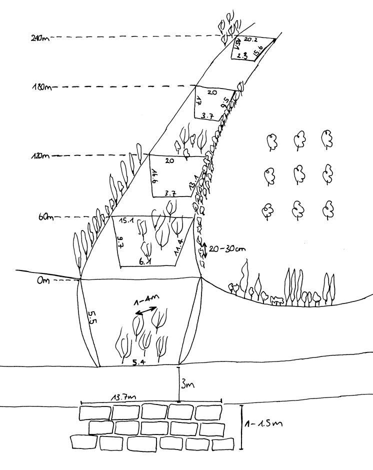
ข้อมูลจำเพาะด้านเทคนิค (แบบแปลนทางเทคนิคของเทคโนโลยี):
The technology includes three different sketch information; 1) dense tree lines on the top of the side slopes, 2) stonewall at the end of the gully and 3) willow trees at the bottom of the gully.
Location: Chinoro. Faizabad/Javonon/Tajikistan
Date: 03.09.2012
Technical knowledge required for field staff / advisors: high (People do not accept a suggestion if it is not from a good educated, accepted person.)
Technical knowledge required for land users: low
Main technical functions: control of concentrated runoff: impede / retard, increase of surface roughness, stabilisation of soil (eg by tree roots against land slides)
Secondary technical functions: control of concentrated runoff: retain / trap, improvement of ground cover, sediment retention / trapping, sediment harvesting, reduction in wind speed, increase of biomass (quantity), promotion of vegetation species and varieties (quality, eg palatable fodder)
Aligned: -contour
Vegetative material: T : trees / shrubs
Aligned: -along boundary
Vegetative material: T : trees / shrubs
Vertical interval within rows / strips / blocks (m): 0.2-0.4
Width within rows / strips / blocks (m): 2m (1-2 Row(s))
Scattered / dispersed
Vegetative material: T : trees / shrubs
Vertical interval within rows / strips / blocks (m): 1-4
Trees/ shrubs species: russian olive, willow tree, acacia, poplar, box
Fruit trees / shrubs species: walnut, apple, apricot, plum, cherries
Wall/ barrier
Vertical interval between structures (m): 0
Spacing between structures (m): 0
Depth of ditches/pits/dams (m): 1.5
Width of ditches/pits/dams (m): 3
Length of ditches/pits/dams (m): 13.7
Construction material (stone): Are taken from a nearby riverbed.
ผู้เขียน:
Selina Studer
4.2 ข้อมูลทั่วไปเกี่ยวกับการคำนวณปัจจัยนำเข้าและค่าใช้จ่าย
อื่นๆ หรือสกุลเงินประจำชาติ (ระบุ):
Tajik Somoni
If relevant, indicate exchange rate from USD to local currency (e.g. 1 USD = 79.9 Brazilian Real): 1 USD =:
4.7
ระบุค่าเฉลี่ยของค่าจ้างในการจ้างแรงงานต่อวัน:
12.00
4.3 กิจกรรมเพื่อการจัดตั้ง
| กิจกรรม | Timing (season) | |
|---|---|---|
| 1. | plant trees in the gully | whole year |
| 2. | plant tree line | whole year |
| 3. | build wall |
4.4 ค่าใช้จ่ายของปัจจัยนำเข้าที่จำเป็นสำหรับการจัดตั้ง
| ปัจจัยนำเข้า | หน่วย | ปริมาณ | ค่าใช้จ่ายต่อหน่วย | ค่าใช้จ่ายทั้งหมดต่อปัจจัยนำเข้า | %ของค่าใช้จ่ายที่ก่อให้เกิดขึ้นโดยผู้ใช้ที่ดิน | |
|---|---|---|---|---|---|---|
| แรงงาน | Build wall | wall | 1.0 | 125.0 | 125.0 | 100.0 |
| แรงงาน | Planting trees | Persons/day | 3.0 | 12.0 | 36.0 | 100.0 |
| วัสดุด้านพืช | Tree seedlings | 1.0 | 166.0 | 166.0 | ||
| ค่าใช้จ่ายทั้งหมดของการจัดตั้งเทคโนโลยี | 327.0 | |||||
| Total costs for establishment of the Technology in USD | 69.57 | |||||
4.5 การบำรุงรักษาสภาพหรือกิจกรรมที่เกิดขึ้นเป็นประจำ
| กิจกรรม | ช่วงระยะเวลา/ความถี่ | |
|---|---|---|
| 1. | add trees in the gully | spring |
| 2. | add trees in the tree line | spring |
| 3. | increase the height of the stonewall | once a while |
4.6 ค่าใช้จ่ายของปัจจัยนำเข้าและกิจกรรมที่เกิดขึ้นเป็นประจำที่ต้องการการบำรุงรักษา (ต่อปี)
| ปัจจัยนำเข้า | หน่วย | ปริมาณ | ค่าใช้จ่ายต่อหน่วย | ค่าใช้จ่ายทั้งหมดต่อปัจจัยนำเข้า | %ของค่าใช้จ่ายที่ก่อให้เกิดขึ้นโดยผู้ใช้ที่ดิน | |
|---|---|---|---|---|---|---|
| แรงงาน | Add trees | Persons/day | 1.0 | 12.0 | 12.0 | 100.0 |
| แรงงาน | Increase the hight of the wall | - | ||||
| ค่าใช้จ่ายทั้งหมดของการบำรุงรักษาสภาพเทคโนโลยี | 12.0 | |||||
| Total costs for maintenance of the Technology in USD | 2.55 | |||||
แสดงความคิดเห็น:
The fact that the inputs for the technology are not evenly distributed throughout the area, the costs were calculated for the whole technology area.
4.7 ปัจจัยสำคัญที่สุดที่มีผลกระทบต่อค่าใช้จ่าย
ปัจจัยสำคัญที่สุดที่มีผลกระทบต่อค่าใช้จ่ายต่างๆ:
The material is relatively affordable. Money intensive factor are the seedlings during establishment phase. Following years the trees reproduce themselves. The establishment of the technology, the planting of the trees and the building of the stonewall require a lot of labour input in the initial phase. As the whole technology does not have to be implemented at once, the work can be split-up over years.
5. สิ่งแวดล้อมทางธรรมชาติและของมนุษย์
5.1 ภูมิอากาศ
ฝนประจำปี
- < 250 ม.ม.
- 251-500 ม.ม.
- 501-750 ม.ม.
- 751-1,000 ม.ม.
- 1,001-1,500 ม.ม.
- 1,501-2,000 ม.ม.
- 2,001-3,000 ม.ม.
- 3,001-4,000 ม.ม.
- > 4,000 ม.ม.
เขตภูมิอากาศเกษตร
- กึ่งแห้งแล้ง
Thermal climate class: temperate
5.2 สภาพภูมิประเทศ
ค่าเฉลี่ยความลาดชัน:
- ราบเรียบ (0-2%)
- ลาดที่ไม่ชัน (3-5%)
- ปานกลาง (6-10%)
- เป็นลูกคลื่น (11-15%)
- เป็นเนิน (16-30%)
- ชัน (31-60%)
- ชันมาก (>60%)
ธรณีสัณฐาน:
- ที่ราบสูง/ที่ราบ
- สันเขา
- ไหล่เขา
- ไหล่เนินเขา
- ตีนเนิน
- หุบเขา
ระดับความสูง:
- 0-100 เมตร
- 101-500 เมตร
- 501-1,000 เมตร
- 1,001-1,500 เมตร
- 1,501-2,000 เมตร
- 2,001-2,500 เมตร
- 2,501-3,000 เมตร
- 3,001-4,000 เมตร
- > 4,000 เมตร
5.3 ดิน
ค่าเฉลี่ยความลึกของดิน:
- ตื้นมาก (0-20 ซ.ม.)
- ตื้น (21-50 ซ.ม.)
- ลึกปานกลาง (51-80 ซ.ม.)
- ลึก (81-120 ซ.ม.)
- ลึกมาก (>120 ซ.ม.)
เนื้อดิน (ดินชั้นบน):
- หยาบ/เบา (ดินทราย)
อินทรียวัตถุในดิน:
- ปานกลาง (1-3%)
- ต่ำ (<1%)
(ถ้ามี) ให้แนบคำอธิบายเรื่องดินแบบเต็มหรือระบุข้อมูลที่มีอยู่ เช่น ชนิดของดิน ค่า pH ของดินหรือความเป็นกรดของดิน ความสามารถในการแลกเปลี่ยนประจุบวก ไนโตรเจน ความเค็ม เป็นต้น:
Soil depth on average: No soil in the gully
Soil fertility is medium for the treeline on top of the slopes of the gully (close to the orchard). but in the gully its very low because the soil was washed away.
Topsoil organic matter is medium at the treeline on top of the gully slope.
Soil drainage / infiltration is medium and in the orchard, gully works as drainage
Soil water storage capacity is very low
5.4 ความเป็นประโยชน์และคุณภาพของน้ำ
ระดับน้ำใต้ดิน:
> 50 เมตร
น้ำไหลบ่าที่ผิวดิน:
ไม่ดีหรือไม่มีเลย
คุณภาพน้ำ (ที่ยังไม่ได้บำบัด):
เป็นน้ำเพื่อการดื่มที่ดี
5.5 ความหลากหลายทางชีวภาพ
ความหลากหลายทางชนิดพันธุ์:
- ต่ำ
5.6 ลักษณะของผู้ใช้ที่ดินที่นำเทคโนโลยีไปปฏิบัติใช้
รายได้ที่มาจากนอกฟาร์ม:
- < 10% ของรายได้ทั้งหมด
ระดับของความมั่งคั่งโดยเปรียบเทียบ:
- จน
- พอมีพอกิน
เป็นรายบุคคล/ครัวเรือน:
- เป็นรายบุคคล/ครัวเรือน
เพศ:
- ชาย
ระบุลักษณะอื่นๆที่เกี่ยวข้องของผู้ใช้ที่ดิน:
Land users applying the Technology are mainly common / average land users
Difference in the involvement of women and men: The technology was directed by the farmer and implemented by the farmer's son. Only men were involved in the technology. In Tajikistan usually work for men and women is strictly divided. Women work in the household, take care for children and work on the field. The gully rehabilitation project was men's work.
Population density: 100-200 persons/km2
Annual population growth: 2% - 3%
10% of the land users are rich (trader which buy and sell products from the farmers).
60% of the land users are average wealthy and own 80% of the land.
30% of the land users are poor and own 20% of the land.
Off-farm income specification: beneath the technology the farmer has an orchard with intercropping, a flax and a wheat plot.
5.7 Average area of land used by land users applying the Technology
- < 0.5 เฮกตาร์
- 0.5-1 เฮกตาร์
- 1-2 เฮกตาร์
- 2-5 เฮกตาร์
- 5-15 เฮกตาร์
- 15-50 เฮกตาร์
- 50-100 เฮกตาร์
- 100-500 เฮกตาร์
- 500-1,000 เฮกตาร์
- 1,000-10,000 เฮกตาร์
- >10,000 เฮกตาร์
พิจารณาว่าเป็นขนาดเล็ก กลาง หรือขนาดใหญ่ (ซึ่งอ้างอิงถึงบริบทระดับท้องถิ่น):
- ขนาดเล็ก
5.8 กรรมสิทธิ์ในที่ดิน สิทธิในการใช้ที่ดินและสิทธิในการใช้น้ำ
กรรมสิทธิ์ในที่ดิน:
- รัฐ
สิทธิในการใช้ที่ดิน:
- เข้าถึงได้แบบเปิด (ไม่ได้จัดระเบียบ)
สิทธิในการใช้น้ำ:
- เกี่ยวกับชุมชน (ถูกจัดระเบียบ)
5.9 การเข้าถึงบริการและโครงสร้างพื้นฐาน
สุขภาพ:
- จน
- ปานกลาง
- ดี
การศึกษา:
- จน
- ปานกลาง
- ดี
ความช่วยเหลือทางด้านเทคนิค:
- จน
- ปานกลาง
- ดี
การจ้างงาน (เช่น ภายนอกฟาร์ม):
- จน
- ปานกลาง
- ดี
ตลาด:
- จน
- ปานกลาง
- ดี
พลังงาน:
- จน
- ปานกลาง
- ดี
ถนนและการขนส่ง:
- จน
- ปานกลาง
- ดี
น้ำดื่มและการสุขาภิบาล:
- จน
- ปานกลาง
- ดี
บริการด้านการเงิน:
- จน
- ปานกลาง
- ดี
6. ผลกระทบและสรุปคำบอกกล่าว
6.1 ผลกระทบในพื้นที่ดำเนินการ (On-site) จากการใช้เทคโนโลยี
ผลกระทบทางด้านเศรษฐกิจและสังคม
การผลิต
การผลิตไม้
พื้นที่สำหรับการผลิต
รายได้และค่าใช้จ่าย
ค่าใช่จ่ายของปัจจัยการผลิตทางการเกษตร
แสดงความคิดเห็น/ระบุ:
Especially at the time of establishment.
ผลกระทบด้านสังคมวัฒนธรรมอื่น ๆ
SLM หรือความรู้เรื่องความเสื่อมโทรมของที่ดิน
แสดงความคิดเห็น/ระบุ:
Land users acquired new knowledge.
security to have fertile land
ผลกระทบด้านนิเวศวิทยา
วัฐจักรน้ำหรือน้ำบ่า
น้ำไหลบ่าที่ผิวดิน
ดิน
สิ่งปกคลุมดิน
การสูญเสียดิน
ความหลากหลายทางชีวภาพของพืชและสัตว์
มวลชีวภาพ/เหนือดินชั้น C
ความหลากหลายทางชีวภาพของพืช
ความหลากหลายทางชีวภาพของสัตว์
ชนิดพันธุ์ที่ให้ประโยชน์
ความหลากหลายของสัตว์
ลดความเสี่ยงของภัยพิบัติ
ความเร็วของลม
แสดงความคิดเห็น/ระบุ:
Treeline
6.2 ผลกระทบนอกพื้นที่ดำเนินการ (Off-site) จากการใช้เทคโนโลยี
น้ำท่วมพื้นที่ท้ายน้ำ
การทับถมของดินตะกอนพื้นที่ท้ายน้ำ
6.3 การเผชิญและความตอบสนองของเทคโนโลยีต่อการเปลี่ยนแปลงสภาพภูมิอากาศที่ค่อยเป็นค่อยไป และสภาพรุนแรงของภูมิอากาศ / ภัยพิบัติ (ที่รับรู้ได้โดยผู้ใช้ที่ดิน)
การเปลี่ยนแปลงสภาพภูมิอากาศที่ค่อยเป็นค่อยไป
การเปลี่ยนแปลงสภาพภูมิอากาศที่ค่อยเป็นค่อยไป
| ฤดู | increase or decrease | เทคโนโลยีมีวิธีการรับมืออย่างไร | |
|---|---|---|---|
| อุณหภูมิประจำปี | เพิ่มขึ้น | ไม่ทราบ |
สภาพรุนแรงของภูมิอากาศ (ภัยพิบัติ)
ภัยพิบัติทางอุตุนิยมวิทยา
| เทคโนโลยีมีวิธีการรับมืออย่างไร | |
|---|---|
| พายุฝนประจำท้องถิ่น | ไม่ค่อยดี |
| พายุลมประจำท้องถิ่น | ดี |
ภัยพิบัติจากสภาพภูมิอากาศ
| เทคโนโลยีมีวิธีการรับมืออย่างไร | |
|---|---|
| ภัยจากฝนแล้ง | ไม่ค่อยดี |
ผลลัพธ์ตามมาที่เกี่ยวข้องกับภูมิอากาศอื่น ๆ
ผลลัพธ์ตามมาที่เกี่ยวข้องกับภูมิอากาศอื่น ๆ
| เทคโนโลยีมีวิธีการรับมืออย่างไร | |
|---|---|
| ช่วงการปลูกพืชที่ลดลงมา | ไม่ค่อยดี |
แสดงความคิดเห็น:
On the bottom of the gully willow trees should be planted which have strong roots to resist floods, especially if the gully is already deep. At the slopes Russian olives and wild cherries can be planted. The higher amount of trees makes gully even more stable.
6.4 การวิเคราะห์ค่าใช้จ่ายและผลประโยชน์ที่ได้รับ
ผลประโยชน์ที่ได้รับเปรียบเทียบกับค่าใช้จ่ายในการจัดตั้งเป็นอย่างไร (จากมุมมองของผู้ใช้ที่ดิน)
ผลตอบแทนระยะสั้น:
เป็นกลางหรือสมดุล
ผลตอบแทนระยะยาว:
ด้านบวกอย่างมาก
ผลประโยชน์ที่ได้รับเปรียบเทียบกับค่าใช้จ่ายในการบำรุงรักษาหรือต้นทุนที่เกิดขึ้นซ้ำอีก เป็นอย่างไร (จากมุมมองของผู้ใช้ที่ดิน)
ผลตอบแทนระยะสั้น:
ด้านบวก
ผลตอบแทนระยะยาว:
ด้านบวกอย่างมาก
แสดงความคิดเห็น:
Much more extra work comes up for the establishment, but for the farmer work is not a disadvantage.
6.5 การปรับตัวของเทคโนโลยี
แสดงความคิดเห็น:
There is a little trend towards spontaneous adoption of the Technology
6.7 จุดแข็ง / ข้อได้เปรียบ / โอกาสของเทคโนโลยี
| จุดแข็ง / ข้อได้เปรียบ / โอกาสในทัศนคติของผู้ใช้ที่ดิน |
|---|
|
Stopping the expansion (prevention) of the gully and filling up the gully (rehabilitation). How can they be sustained / enhanced? Maintain the vegetative measures, plant more seedlings and let them reproduce themselves. |
|
Firewood and construction material production. How can they be sustained / enhanced? Increase the vegetation with wood of good quality and use it in a sustainable manner (cut only as much as will be reproduced). |
| จุดแข็ง / ข้อได้เปรียบ / โอกาสในทัศนคติของผู้รวบรวมหรือวิทยากรหลัก |
|---|
|
Extensive use of the area and a relatively rich diversity of local vegetation. The maintained gully provides new habitat for natural flora and fauna. How can they be sustained / enhanced? Keep and promote the diversity of plants in the gully. |
|
Cheap and relatively less labor intensive work. Relatively little knowledge and no special tools are required. How can they be sustained / enhanced? Make the technology public. |
| The entire technology doesn’t have to be established at once, which allows investing money and time whenever it is available. |
6.8 จุดอ่อน / ข้อเสียเปรียบ / ความเสี่ยงของเทคโนโลยีและวิธีการแก้ไข
| จุดอ่อน / ข้อเสียเปรียบ / ความเสี่ยงในทัศนคติของผู้ใช้ที่ดิน | มีวิธีการแก้ไขได้อย่างไร |
|---|---|
| The trees stop the water, sediments, branches etc. too effectively and this creates problems with too much water in the gully, which is washing out the sides of the gully. |
| จุดอ่อน / ข้อเสียเปรียบ / ความเสี่ยงในทัศนคติของผู้รวบรวมหรือวิทยากรหลัก | มีวิธีการแก้ไขได้อย่างไร |
|---|---|
| A disadvantage is the extra work the farmer have to spend on a little productive area. | In the land users view work is not a disadvantage, it is his job. Considering the fact that it is not that much extra work, it is not a big disadvantage. |
| For the establishment a first investment for the seedlings is required. | An establishment of the technology during a longer period allows to grow own seedlings from the plants which do not cost anything. |
7. การอ้างอิงและการเชื่อมต่อ
7.1 วิธีการและแหล่งข้อมูล
7.2 การอ้างอิงถึงสิ่งตีพิมพ์
หัวข้อ, ผู้เขียน, ปี, หมายเลข ISBN:
Integrated spatial assessment for Sustainable Land Management „SLM-planning“ in the loess hill of central Tajikistan using WOCAT mapping tools (working title), Selina Studer, 2013, Master Thesis, University of Bern, Bern.
ชื่อเรื่อง ผู้เขียน ปี ISBN:
University of Bern
7.3 Links to relevant online information
ชื่อเรื่องหรือคำอธิบาย:
WOCAT technology movie: Orchard-Based Agroforestry
URL:
wocat@cde.ch
ลิงก์และโมดูล
ขยายทั้งหมด ย่อทั้งหมดลิงก์
ไม่มีลิงก์
โมดูล
ไม่มีโมดูล