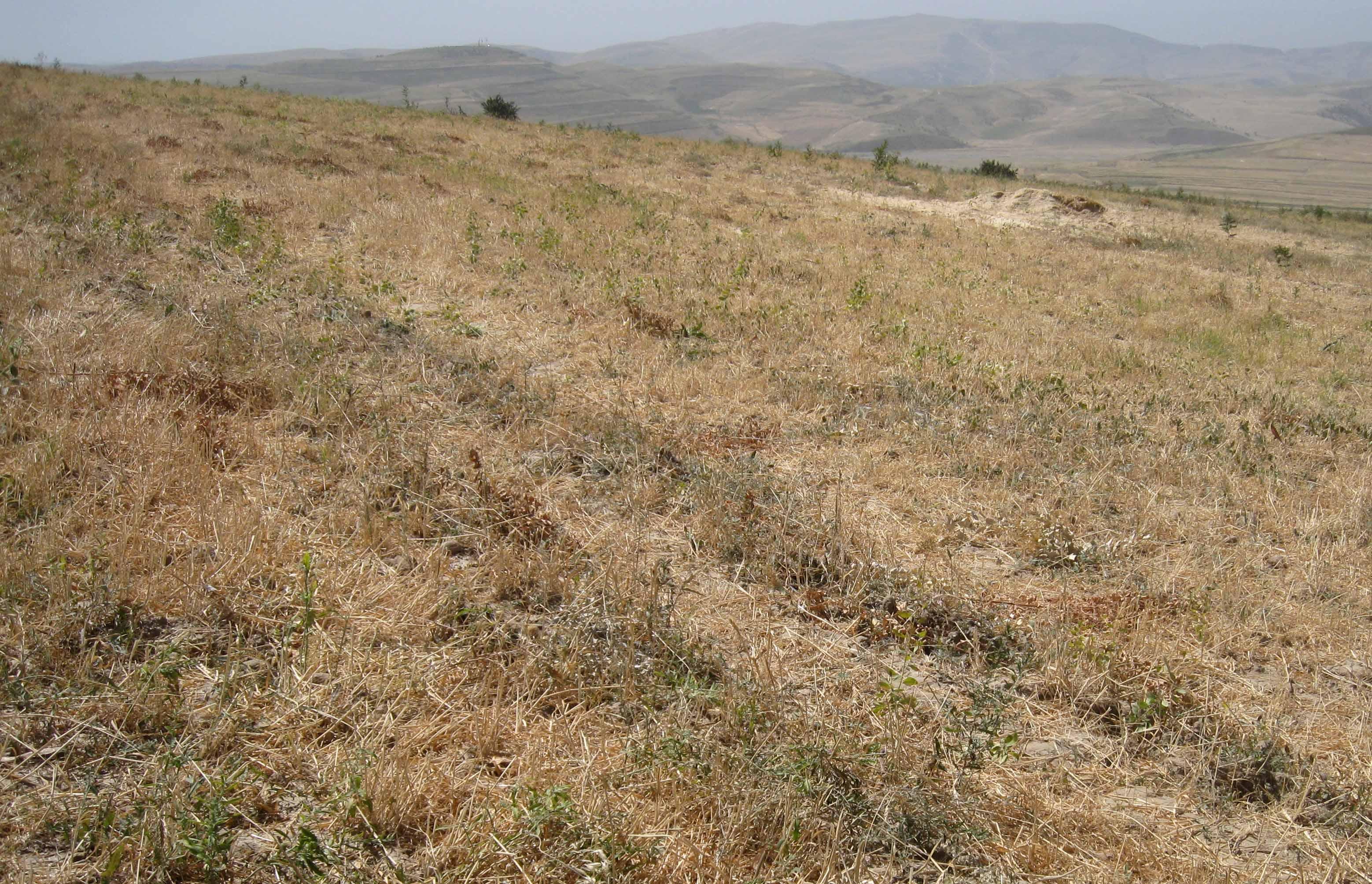
Current wheat crop in rotation with chickpea cultivation [Tajikistan]
- Creation:
- Update:
- Compiler: Malgorzata Conder
- Editor: –
- Reviewers: Fabian Ottiger, Alexandra Gavilano
technologies_1552 - Tajikistan
View sections
Expand all Collapse all1. General information
1.2 Contact details of resource persons and institutions involved in the assessment and documentation of the Technology
Name of project which facilitated the documentation/ evaluation of the Technology (if relevant)
Knowledge Management for Integrated Watershed Management and Disaster Risk Reduction (SDC / IWSM)Name of the institution(s) which facilitated the documentation/ evaluation of the Technology (if relevant)
CDE Centre for Development and Environment (CDE Centre for Development and Environment) - Switzerland1.3 Conditions regarding the use of data documented through WOCAT
When were the data compiled (in the field)?
06/09/2012
The compiler and key resource person(s) accept the conditions regarding the use of data documented through WOCAT:
Yes
1.4 Declaration on sustainability of the described Technology
Is the Technology described here problematic with regard to land degradation, so that it cannot be declared a sustainable land management technology?
No
2. Description of the SLM Technology
2.1 Short description of the Technology
Definition of the Technology:
Current wheat crop in yearly rotation with chickpea cultivation
2.2 Detailed description of the Technology
Description:
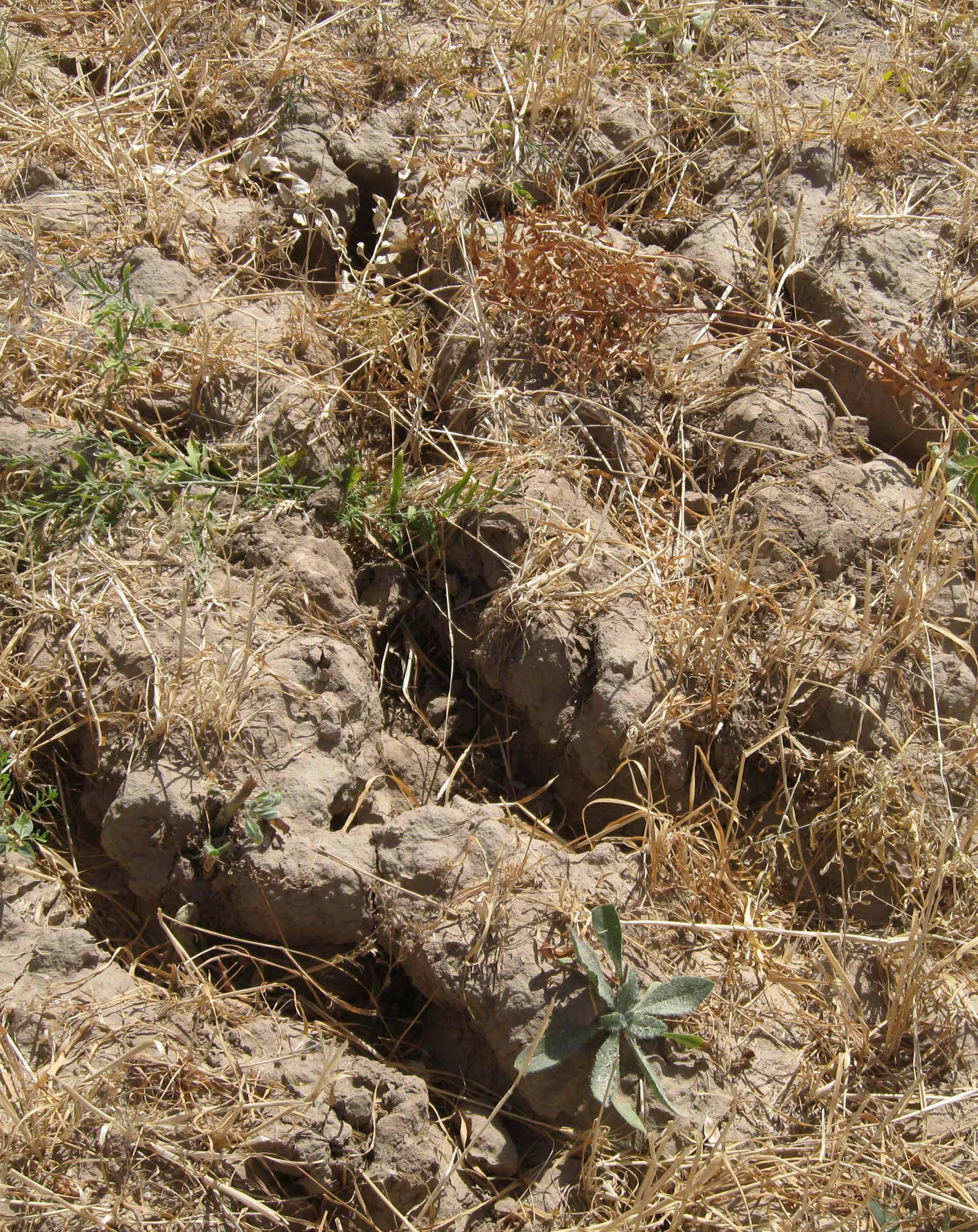
The rainfed crop of the farmer sizes around a hectare. He owns the crop since seven years and switches between chickpea and wheat every year. When he started to cultivate, soil properties were good, he did not use fertilizer. Because of the years of ploughing, the soil lost nutrients and moisture. The more rill building and slope instability is severe currently. The plot is over one hectare because it includes a narrow vegetation strip between his and the neighbours crop. The plot, as all the other crops are grazed by livestock, after harvest.
Purpose of the Technology: Chickpea cropping generates a satisfactory yield, whereas wheat production is rather variable and low. Nevertheless the farmer would not change the crop type because the main purpose is to get straw for feeding his cows. The farmer has over three hectares in total. Even though he claims the benefit to be low comparing to the input, he is content as long he can feed his family.
Establishment / maintenance activities and inputs: Ploughing, sowing and then harvesting were part of the establishment phase. The same activities count for maintenance. But as soil is gradually washed away, fertilizing became crucial. The farmer does not control and protect the crop from wild animals and grazing herds.
Natural / human environment: The crop lies on a foot slope not far from the riverbed. Neighbouring cultivations are of the same crop type, chickpea, wheat and food grain. It is less than one kilometre away from the farmers home in Doshmand village. Access to services is rather low, especially in winter, because of the bad condition of the road. Doctor, middle and higher school grades and market are in the village below.
2.3 Photos of the Technology
Media Gallery
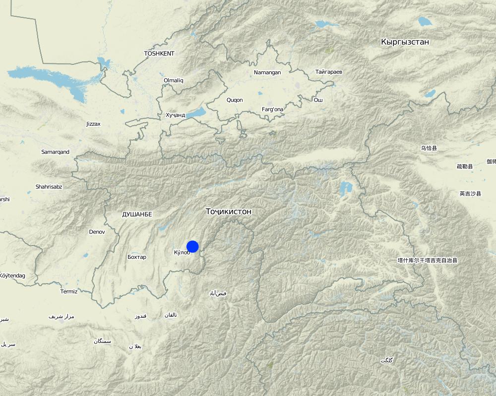
2.5 Country/ region/ locations where the Technology has been applied and which are covered by this assessment
Country:
Tajikistan
Region/ State/ Province:
Khatlon, Tajikistan
Further specification of location:
Muminabad
Comments:
Specify the spread of the Technology:
evenly spread over an area
If the Technology is evenly spread over an area, indicate approximate area covered:
< 0.1 km2 (10 ha)
Comments:
Total area covered by the SLM Technology is 0.01 km2.
Crop counts around 1 ha. Total plot is over 1 ha, because of a narrow vegative strip underneath the crop.
Map
×3. Classification of the SLM Technology
3.1 Main purpose(s) of the Technology
- improve production
- reduce, prevent, restore land degradation
3.2 Current land use type(s) where the Technology is applied

Cropland
- Annual cropping
Main crops (cash and food crops):
Major food crop: Wheat
chickpea, wheat and food grain
Comments:
Major land use problems (compiler’s opinion): Sealed and compacted topsoil, which hinders infiltration. Hardpan is propable due to plowing. Erosive processes with rill building are relatively widespread on the crop. A lot of plowing rills aggrandize by runoff. A lot of licorish plant grow on the crop, which is a indicator for degraded soil. Soil shows a low level of organic matter, nutrients and moisture.
Major land use problems (land users’ perception): Increasing soil wash out with simultaneos augmentation of fertilizer input over years. Rills destroy crop growth, reason why yield quantity and quality is decreasing.
Type of cropping system and major crops comments: Farmer doesn't try hard to get a better yield. As long as he can feed his family he doesn't see the real need to do that.
Livestock is grazing on crop residues
3.3 Further information about land use
Water supply for the land on which the Technology is applied:
- rainfed
Number of growing seasons per year:
- 1
Specify:
Longest growing period in days: 180 Longest growing period from month to month: March to September
3.4 SLM group to which the Technology belongs
- rotational systems (crop rotation, fallows, shifting cultivation)
3.5 Spread of the Technology
Specify the spread of the Technology:
- evenly spread over an area
If the Technology is evenly spread over an area, indicate approximate area covered:
- < 0.1 km2 (10 ha)
Comments:
Total area covered by the SLM Technology is 0.01 km2.
Crop counts around 1 ha. Total plot is over 1 ha, because of a narrow vegative strip underneath the crop.
3.7 Main types of land degradation addressed by the Technology

soil erosion by water
- Wt: loss of topsoil/ surface erosion
- Wg: gully erosion/ gullying

chemical soil deterioration
- Cn: fertility decline and reduced organic matter content (not caused by erosion)

physical soil deterioration
- Pk: slaking and crusting

water degradation
- Hs: change in quantity of surface water
Comments:
Main type of degradation addressed: Wt: loss of topsoil / surface erosion, Wg: gully erosion / gullying, Cn: fertility decline and reduced organic matter content
Secondary types of degradation addressed: Pk: sealing and crusting, Hs: change in quantity of surface water
Main causes of degradation: soil management, crop management (annual, perennial, tree/shrub), land tenure (For private cropping and communal grazing)
Secondary causes of degradation: overgrazing, disturbance of water cycle (infiltration / runoff), Heavy / extreme rainfall (intensity/amounts)
3.8 Prevention, reduction, or restoration of land degradation
Specify the goal of the Technology with regard to land degradation:
- restore/ rehabilitate severely degraded land
4. Technical specifications, implementation activities, inputs, and costs
4.2 Technical specifications/ explanations of technical drawing
Contour lined plot, with a vegetation strip of < 1m width, between this and the underneath plot. A lot of rills visible.
Location: Doshmand, Chukurak Watershed. Muminabad, Khatlon, Tajikistan
Main technical functions: control of concentrated runoff: drain / divert, improvement of surface structure (crusting, sealing), stabilisation of soil (eg by tree roots against land slides), increase in organic matter, increase of infiltration
Secondary technical functions: control of concentrated runoff: impede / retard, improvement of ground cover, increase of surface roughness, improvement of topsoil structure (compaction), improvement of subsoil structure (hardpan), increase in nutrient availability (supply, recycling,…), increase / maintain water stored in soil
4.3 General information regarding the calculation of inputs and costs
other/ national currency (specify):
Somoni
Indicate exchange rate from USD to local currency (if relevant): 1 USD =:
4.83
Indicate average wage cost of hired labour per day:
12.40
4.5 Costs and inputs needed for establishment
| Specify input | Unit | Quantity | Costs per Unit | Total costs per input | % of costs borne by land users | |
|---|---|---|---|---|---|---|
| Labour | Sowing | Person days | 0.25 | 12.4 | 3.1 | 100.0 |
| Labour | Applying fertilizer | Person days | 0.25 | 12.4 | 3.1 | 100.0 |
| Labour | Cutting wheat | Person days | 18.0 | 12.422 | 223.6 | 100.0 |
| Labour | Plowing | Person days | 0.4375 | 12.4 | 5.42 | 100.0 |
| Equipment | Machine use | Hours | 3.5 | 5.914 | 20.7 | 100.0 |
| Equipment | Petrol | Liters | 40.0 | 1.1375 | 45.5 | 100.0 |
| Plant material | Seeds | 150.0 | 0.414 | 62.1 | ||
| Fertilizers and biocides | Fertilizer | Bucks | 2.0 | 31.05 | 62.1 | 100.0 |
| Total costs for establishment of the Technology | 425.62 | |||||
Comments:
Duration of establishment phase: 0.125 month(s)
4.6 Maintenance/ recurrent activities
| Activity | Type of measure | Timing/ frequency | |
|---|---|---|---|
| 1. | Plowing, 3.5 hours, 1 person | Agronomic | every year, spring |
| 2. | Sowing wheat, 1 hour, 2 persons | Agronomic | every year, spring |
| 3. | Applying fertilizer (not in the first year), 1 hour, 2 persons | Agronomic | only once a year in spring, more year by year |
| 4. | Cutting wheat, 6 days (à 8 hours), 3 persons | Agronomic | once a year, around semptember |
4.8 Most important factors affecting the costs
Describe the most determinate factors affecting the costs:
Establishment and maintenance cost are similar. Agricultural inputs as seeds and fertilizer are the highest expenditures. As soil nutrients are washed out, the fertilizer input rises gradually.
5. Natural and human environment
5.1 Climate
Annual rainfall
- < 250 mm
- 251-500 mm
- 501-750 mm
- 751-1,000 mm
- 1,001-1,500 mm
- 1,501-2,000 mm
- 2,001-3,000 mm
- 3,001-4,000 mm
- > 4,000 mm
Specifications/ comments on rainfall:
Totally 800 mm: 700mm in winter-spring, July-Sept dry season
Agro-climatic zone
- sub-humid
Thermal climate class: temperate, LPG from end of March until September
5.2 Topography
Slopes on average:
- flat (0-2%)
- gentle (3-5%)
- moderate (6-10%)
- rolling (11-15%)
- hilly (16-30%)
- steep (31-60%)
- very steep (>60%)
Landforms:
- plateau/plains
- ridges
- mountain slopes
- hill slopes
- footslopes
- valley floors
Altitudinal zone:
- 0-100 m a.s.l.
- 101-500 m a.s.l.
- 501-1,000 m a.s.l.
- 1,001-1,500 m a.s.l.
- 1,501-2,000 m a.s.l.
- 2,001-2,500 m a.s.l.
- 2,501-3,000 m a.s.l.
- 3,001-4,000 m a.s.l.
- > 4,000 m a.s.l.
Comments and further specifications on topography:
Altitudinal zone: 1501-2000 m a.s.l. (1600 m asl)
5.3 Soils
Soil depth on average:
- very shallow (0-20 cm)
- shallow (21-50 cm)
- moderately deep (51-80 cm)
- deep (81-120 cm)
- very deep (> 120 cm)
Soil texture (topsoil):
- medium (loamy, silty)
- fine/ heavy (clay)
If available, attach full soil description or specify the available information, e.g. soil type, soil PH/ acidity, Cation Exchange Capacity, nitrogen, salinity etc.
Soil fertility: Low
Soil drainage/infiltration: Poor (sealing and probably hard pan)
Soil water storage capacity: Low
5.4 Water availability and quality
Water quality (untreated):
for agricultural use only (irrigation)
5.5 Biodiversity
Species diversity:
- low
5.6 Characteristics of land users applying the Technology
Market orientation of production system:
- subsistence (self-supply)
Off-farm income:
- less than 10% of all income
Relative level of wealth:
- average
Individuals or groups:
- individual/ household
Level of mechanization:
- manual work
- mechanized/ motorized
Gender:
- men
Indicate other relevant characteristics of the land users:
Land users applying the Technology are mainly common / average land users
Population density: 100-200 persons/km2
Annual population growth: 1% - 2%
Off-farm income specification: The farmer has in total over 3 ha of crop. The output of straw of this one hectare makes 40% of his total income.
Level of mechanization: Manual labour (harvesting wheat) and mechanised (plowing)
5.7 Average area of land owned or leased by land users applying the Technology
- < 0.5 ha
- 0.5-1 ha
- 1-2 ha
- 2-5 ha
- 5-15 ha
- 15-50 ha
- 50-100 ha
- 100-500 ha
- 500-1,000 ha
- 1,000-10,000 ha
- > 10,000 ha
Is this considered small-, medium- or large-scale (referring to local context)?
- small-scale
Comments:
2.06 ha (household 7.7 members)
5.8 Land ownership, land use rights, and water use rights
Land ownership:
- individual, titled
Land use rights:
- leased
Water use rights:
- communal (organized)
Comments:
Land ownership is based on the Land user's certificate
5.9 Access to services and infrastructure
health:
- poor
- moderate
- good
education:
- poor
- moderate
- good
technical assistance:
- poor
- moderate
- good
employment (e.g. off-farm):
- poor
- moderate
- good
markets:
- poor
- moderate
- good
energy:
- poor
- moderate
- good
roads and transport:
- poor
- moderate
- good
drinking water and sanitation:
- poor
- moderate
- good
financial services:
- poor
- moderate
- good
6. Impacts and concluding statements
6.1 On-site impacts the Technology has shown
Socio-economic impacts
Production
crop production
risk of production failure
Income and costs
expenses on agricultural inputs
Comments/ specify:
demand on fertilizers is increasing
farm income
Comments/ specify:
gradually increasing
Socio-cultural impacts
food security/ self-sufficiency
Comments/ specify:
Only on long term according to the farmer
Ecological impacts
Water cycle/ runoff
surface runoff
Comments/ specify:
Many rills
Soil
soil moisture
soil cover
soil crusting/ sealing
soil compaction
soil organic matter/ below ground C
Climate and disaster risk reduction
wind velocity
6.2 Off-site impacts the Technology has shown
downstream flooding
buffering/ filtering capacity
6.3 Exposure and sensitivity of the Technology to gradual climate change and climate-related extremes/ disasters (as perceived by land users)
Gradual climate change
Gradual climate change
| Season | Type of climatic change/ extreme | How does the Technology cope with it? | |
|---|---|---|---|
| annual temperature | increase | not well |
Climate-related extremes (disasters)
Meteorological disasters
| How does the Technology cope with it? | |
|---|---|
| local rainstorm | not well |
| local windstorm | not known |
Climatological disasters
| How does the Technology cope with it? | |
|---|---|
| drought | not well |
Hydrological disasters
| How does the Technology cope with it? | |
|---|---|
| general (river) flood | not well |
Other climate-related consequences
Other climate-related consequences
| How does the Technology cope with it? | |
|---|---|
| reduced growing period | not known |
Comments:
The crop would be less sensitive to heavy (seasonal) rainfalls or droughts if vegetation cover or mulching would be improved.
6.4 Cost-benefit analysis
Comments:
Farmer knows that there is no real benefit when looking at the input. Over the years it got slightly negative because more fertilizer is needed and yield is decreasing.
6.7 Strengths/ advantages/ opportunities of the Technology
| Strengths/ advantages/ opportunities in the compiler’s or other key resource person’s view |
|---|
|
Vegetation strip underneath the crop is an idea to develop as it reduces the negative offsite effects. How can they be sustained / enhanced? Knowledge transfer about how to reduce offsite effects. Soil cover could rise in that strip, thanks do what soil erosion woul be stopped. Enhance communication between above and below vegetation strip cultivating farmers. |
|
Maintain and develop crop rotation. How can they be sustained / enhanced? Knowledge transfer and field studies on other plots with crop rotation (e.g. perennial crops). |
| Plowing horizontally. |
6.8 Weaknesses/ disadvantages/ risks of the Technology and ways of overcoming them
| Weaknesses/ disadvantages/ risks in the compiler’s or other key resource person’s view | How can they be overcome? |
|---|---|
| Too much soil erosion causes rills. | Another crop type according to the steepness of the plot. Change plowing deepness or do human-powered tillage. |
| Development of soil crust, sealing and hardpan. | Enhance crop rotation and "soft" and horizontal tillage practices. |
| Observed trampling and grazing of the plot. | Guarding or fencing of the plot. Guarding could be organized by several farmers in rotation. |
| Poor pecentage of organic matter. | Introduce mulching. |
Links and modules
Expand all Collapse allLinks
No links
Modules
No modules