Pasture management through rotational grazing [Tajikistan]
- Creation:
- Update:
- Compiler: Malgorzata Conder
- Editor: –
- Reviewers: Deborah Niggli, David Streiff, Alexandra Gavilano
technologies_1585 - Tajikistan
View sections
Expand all Collapse all1. General information
1.2 Contact details of resource persons and institutions involved in the assessment and documentation of the Technology
SLM specialist:
1.3 Conditions regarding the use of data documented through WOCAT
The compiler and key resource person(s) accept the conditions regarding the use of data documented through WOCAT:
Yes
1.4 Declaration on sustainability of the described Technology
Is the Technology described here problematic with regard to land degradation, so that it cannot be declared a sustainable land management technology?
No
2. Description of the SLM Technology
2.1 Short description of the Technology
Definition of the Technology:
Rotational grazing on private grazing land used as daily pastures
2.2 Detailed description of the Technology
Description:
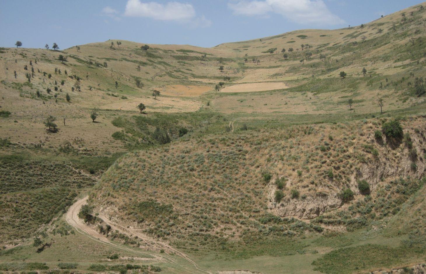
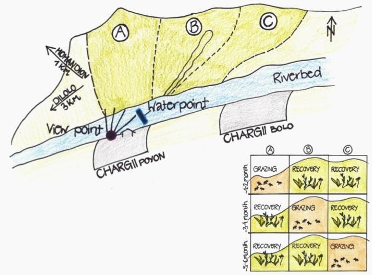
A riverbed divides the pasture where rotational grazing is practiced with the village Chargii poyon, where the certified land user and owner of the pasture lives. From a view point nearby his house, he has a good view on and hence a good control over the pasture area. This allows him to keep intrusive livestock outside, having a limited number of grazing livestock in the pasture. The area encompasses 119 ha, from which 5 ha are rented out as crop land.
Land tenure conflicts about this pasture existed over many years, because there wasn’t declared any owner. The certified land user of Chargii poyon claims to possess the pasture since 1999. It is unclear how he got the land transferred. Being aware of the ongoing degradation of this land, the certified land user divided the area into 3 parts and introduced controlled grazing in 2007. While one part is being grazed the other two lie fallow. After one to two months of grazing in one area, the herds move to the next area. The rotation phases depend on the availability of grass. In June 2012, at the moment of documentation, there were 145 cows and some 30 goats and sheep. The number of animals is varying seasonally, with a higher amount of animals in summer than in winter. Compared to other pastures in summer, more grass in available on the pasture with rotational grazing. In winter grass availability is comparable between the pastures. This may explain why a higher number of livestock is recorded on the pasture with rotational grazing in summer.
The pasture is controlled by the farmer and further 4 people to avoid livestock intrusion.
In a seminar organized by Caritas Switzerland, the farmer learned about increasing long-term productivity of pastures by vegetation recovery. The idea of pasture rotation convinced him in order to raise productivity on long-term. The main reasons for changing the pasture management were the advanced stage of deforestation, increasing overgrazing, and the additional source to get the land taxes paid. The management of the pasture by rotational grazing on three areas allows the non-grazed areas to rest and recover. Less grazed and trampled areas result in an increase of the vegetation cover and thus to higher fodder quality, as well as increased soil stability and therefore a reduced risk of disasters, such as floods.
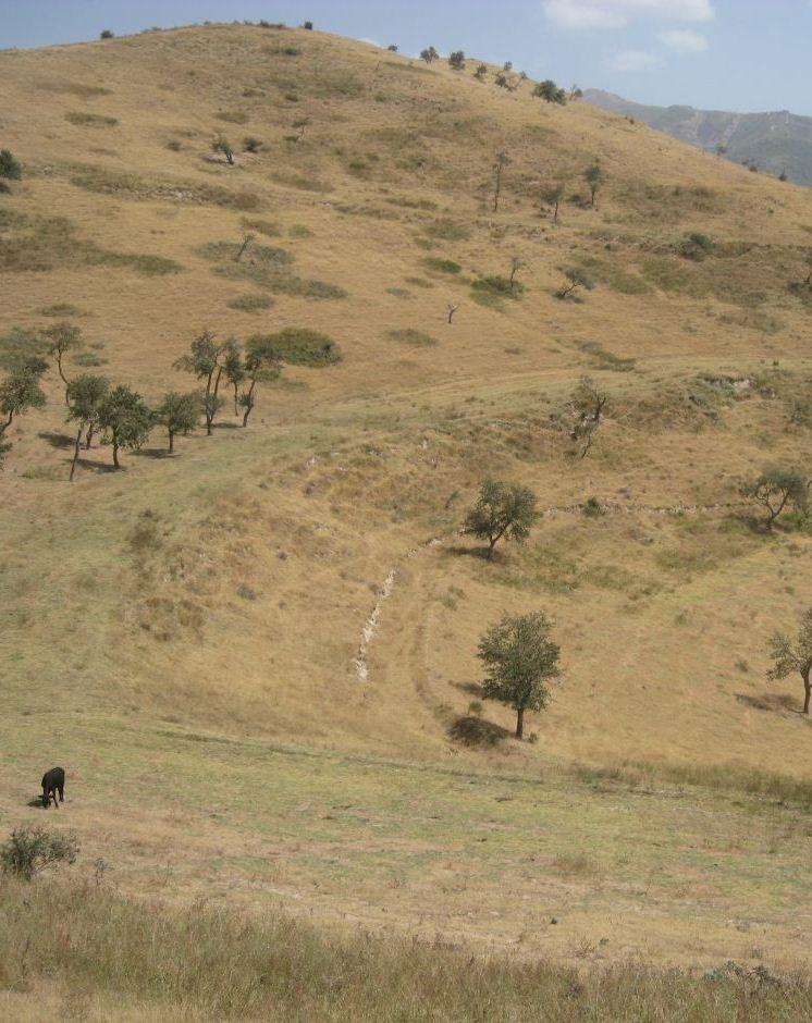
The farmer expected that the implementation of land conservation measures would stop the on-going pasture degradation and would assure long-term and sustainable use of the land. Despite the rotating system, the grazing land is still overgrazed and shows signs indicating moderate erosion, but it is less degraded than other pastures in the watershed. The area being the most far away from the settlement is in best conditions. The closer to the riverbed the more degraded and eroded the pasture is.
Additional measures are necessary to reduce soil erosion and gully formation in the area
Livestock owners have to pay a fee to the farmer for grazing cows, but not for grazing sheep and goats. The amount of the fee depends on the provenance of the herder. Fees vary greatly between the villages. Because of solidarity, Chargii villagers pay much less than herders from villages located further away. Momandion villagers pay 3 times, Dilolo villagers even 9 times more than Chargi villagers. But the certified land user claims to be flexible in the amount of fees for poor herders. He has to pay taxes to the government for the property and salary to the surveillants. If more money is available, also generated by the fees, the certified land user claims to invest a part of the money into the pasture. He would like to build another water point and to plant trees in the upper area. Livestock could graze in more remote areas which would reduce the pressure on the pastures in the lower area and decrease the soil compaction.
The pasture is located in the middle zone of the Obishur watershed and on the foothill above the riverbed plain. This pasture, located between the villages of Chargi poyon, Chargi bolo and Momandion and not far from Dilolo village, is a reachable place for many livestock of private households. In the riverbed, the only water point is installed where livestock is watered at midday. Due to tree cutting in the past, only a few shady places exist. Vegetation cover varies depending on the exposition of the slopes and the accessibility of the pasture. North-facing slopes have a more abundant vegetation cover. Some flanks are difficult to reach because of dense thorn bushes. A big gully, hardly accessible by livestock, is about to be covered again by naturally re-growing bushes and trees. Nevertheless, signs of erosion and rill building can be observed. Due to the closeness to the villages and to the pressure on natural resources it is crucial to sustain a controlled pasture management.
2.3 Photos of the Technology
Media Gallery
2.5 Country/ region/ locations where the Technology has been applied and which are covered by this assessment
Country:
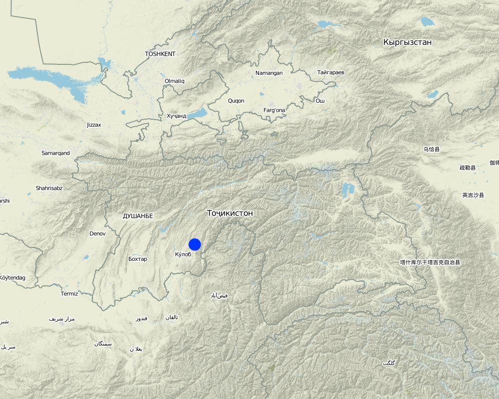
Tajikistan
Region/ State/ Province:
Khatlon, Tajikistan
Further specification of location:
Muminabad
Specify the spread of the Technology:
- evenly spread over an area
If precise area is not known, indicate approximate area covered:
- 1-10 km2
Comments:
Total area covered by the SLM Technology is 1.14 km2.
Total area is 119 ha, but 5 ha out of it are rented for cropping
Map
×2.6 Date of implementation
If precise year is not known, indicate approximate date:
- less than 10 years ago (recently)
2.7 Introduction of the Technology
Specify how the Technology was introduced:
- through projects/ external interventions
Comments (type of project, etc.):
Idea of how to improve ground cover was initiated by a workshop from Caritas, but the rotational grazing was introduced by the farmer himself in 2007
3. Classification of the SLM Technology
3.1 Main purpose(s) of the Technology
- improve production
- reduce, prevent, restore land degradation
3.2 Current land use type(s) where the Technology is applied

Grazing land
Extensive grazing:
- Semi-nomadic pastoralism
- rotational grazing
Animal type:
- goats
- sheep
- cows
Comments:
Livestock density (if relevant):
> 100 LU /km2
Major land use problems (compiler’s opinion): Overgrazed pasture with frequent big gullies, rills and trampled areas. Almost complete deforestation of the grazing land.
Major land use problems (land users’ perception): Lack of water availability and water points for grazing livestock. Gradual degradation and erosion of the pasture which has to be stopped.
Grazingland comments: Rotation within 119 ha of grazing land
3.4 Water supply
Water supply for the land on which the Technology is applied:
- rainfed
3.5 SLM group to which the Technology belongs
- rotational systems (crop rotation, fallows, shifting cultivation)
- pastoralism and grazing land management
3.6 SLM measures comprising the Technology

management measures
- M2: Change of management/ intensity level
3.7 Main types of land degradation addressed by the Technology

soil erosion by water
- Wt: loss of topsoil/ surface erosion
- Wg: gully erosion/ gullying

chemical soil deterioration
- Cn: fertility decline and reduced organic matter content (not caused by erosion)

physical soil deterioration
- Pc: compaction

biological degradation
- Bc: reduction of vegetation cover
Comments:
Main causes of degradation: overgrazing, governance / institutional (No/ Insufficient management planning and control), livestock pressure (Due to subsistence of the population)
Secondary causes of degradation: deforestation / removal of natural vegetation (incl. forest fires), disturbance of water cycle (infiltration / runoff) (impact of overgrazing and deforestation), education, access to knowledge and support services
3.8 Prevention, reduction, or restoration of land degradation
Specify the goal of the Technology with regard to land degradation:
- reduce land degradation
- restore/ rehabilitate severely degraded land
4. Technical specifications, implementation activities, inputs, and costs
4.1 Technical drawing of the Technology
Technical specifications (related to technical drawing):
The hilly pasture of 114 ha in total is divided more or less vertically in 3 areas. In each area, the pasture between the ridge and the riverbed is covered. After having grazed one area for approximately one to two months, the herd moves to the next part. This means that two areas rest and grasses recover, while one is being grazed.
Location: Chargii poyon. Muminobod, Kathlon, Tajikistan
Technical knowledge required for field staff / advisors: low (When benefits of pasture management are known and understood, high technical knowledge isn't required)
Technical knowledge required for land users: low (When benefits of pasture management are known and understood, high technical knowledge isn't required)
Main technical functions: control of concentrated runoff: impede / retard, control of concentrated runoff: drain / divert, improvement of ground cover, increase of infiltration
Secondary technical functions: increase of surface roughness, improvement of surface structure (crusting, sealing), improvement of topsoil structure (compaction), stabilisation of soil (eg by tree roots against land slides), increase in organic matter, increase / maintain water stored in soil, sediment retention / trapping, sediment harvesting
Change of land use practices / intensity level: In 2007 controlled and rotational grazing was introduced where no pasture management existed before
Author:
Malgorzata Conder
4.2 General information regarding the calculation of inputs and costs
Specify currency used for cost calculations:
- USD
Indicate average wage cost of hired labour per day:
12.40
4.3 Establishment activities
| Activity | Timing (season) | |
|---|---|---|
| 1. | Introduction/information of pasture management among the herders | once in 2007 |
4.4 Costs and inputs needed for establishment
| Specify input | Unit | Quantity | Costs per Unit | Total costs per input | % of costs borne by land users | |
|---|---|---|---|---|---|---|
| Labour | Introduction/information of pasture management among the herders | - | 1.0 |
Comments:
Duration of establishment phase: 1 month(s)
4.5 Maintenance/ recurrent activities
| Activity | Timing/ frequency | |
|---|---|---|
| 1. | Salary for 5 people to guard pasture and herders: Monthly salary 70 Som/pers, pers d unknown | every day, from spring until autumn |
| 2. | Annual Rent | once a year |
4.6 Costs and inputs needed for maintenance/ recurrent activities (per year)
| Specify input | Unit | Quantity | Costs per Unit | Total costs per input | % of costs borne by land users | |
|---|---|---|---|---|---|---|
| Labour | Guarding pasture and herders | Persons/6months | 5.0 | 86.96 | 434.8 | 100.0 |
| Other | Annual rent | ha | 114.0 | 1.359649 | 155.0 | 100.0 |
| Total costs for maintenance of the Technology | 589.8 | |||||
| Total costs for maintenance of the Technology in USD | 589.8 | |||||
Comments:
Costs which concern the information transfer to the herders is not calculated, as it is done informally. Only guardening by the employed people is monetarised.
4.7 Most important factors affecting the costs
Describe the most determinate factors affecting the costs:
The farmer already owns the land user certificate for the property and only has to pay annual taxes and the people who control the pasture. He covers these costs with the rent he gets for the grazing livestock.
5. Natural and human environment
5.1 Climate
Annual rainfall
- < 250 mm
- 251-500 mm
- 501-750 mm
- 751-1,000 mm
- 1,001-1,500 mm
- 1,501-2,000 mm
- 2,001-3,000 mm
- 3,001-4,000 mm
- > 4,000 mm
Specifications/ comments on rainfall:
Totally 800mm: 700mm in winter-spring, July-Sept dry season (At 1200mm asl, wheater station Muminabad). Precipitation increases 60mm per 100m of altitude in average.
Agro-climatic zone
- sub-humid
Thermal climate class: temperate
5.2 Topography
Slopes on average:
- flat (0-2%)
- gentle (3-5%)
- moderate (6-10%)
- rolling (11-15%)
- hilly (16-30%)
- steep (31-60%)
- very steep (>60%)
Landforms:
- plateau/plains
- ridges
- mountain slopes
- hill slopes
- footslopes
- valley floors
Altitudinal zone:
- 0-100 m a.s.l.
- 101-500 m a.s.l.
- 501-1,000 m a.s.l.
- 1,001-1,500 m a.s.l.
- 1,501-2,000 m a.s.l.
- 2,001-2,500 m a.s.l.
- 2,501-3,000 m a.s.l.
- 3,001-4,000 m a.s.l.
- > 4,000 m a.s.l.
Comments and further specifications on topography:
Slopes on average: Some flanks over 40%
Slopes on average: Also rolling
5.3 Soils
Soil depth on average:
- very shallow (0-20 cm)
- shallow (21-50 cm)
- moderately deep (51-80 cm)
- deep (81-120 cm)
- very deep (> 120 cm)
Soil texture (topsoil):
- medium (loamy, silty)
- fine/ heavy (clay)
Topsoil organic matter:
- low (<1%)
If available, attach full soil description or specify the available information, e.g. soil type, soil PH/ acidity, Cation Exchange Capacity, nitrogen, salinity etc.
Soil fertility: Low-medium
Soil drainage / infiltration: Poor-medium
Soil water storage capacity: Low
5.4 Water availability and quality
Ground water table:
5-50 m
Availability of surface water:
poor/ none
Water quality (untreated):
poor drinking water (treatment required)
Comments and further specifications on water quality and quantity:
Water quality (untreated): For livestock, surface water in spring (because of snow melting and rainfall), in summer ground water at one water point
5.5 Biodiversity
Species diversity:
- low
Comments and further specifications on biodiversity:
Tree cutting, due to grazing more and more uneatable species
5.6 Characteristics of land users applying the Technology
Market orientation of production system:
- subsistence (self-supply)
Off-farm income:
- less than 10% of all income
Relative level of wealth:
- rich
Individuals or groups:
- individual/ household
Gender:
- men
Indicate other relevant characteristics of the land users:
Land users applying the Technology are mainly Leaders / privileged
Difference in the involvement of women and men: Men are taking decisions and administrating the property whereas women are working on the field. Privileged land user because he owns a big area.
Population density: 100-200 persons/km2
Annual population growth: 1% - 2% (Farmer owns a big property of 119 ha).
Off-farm income specification: Additionally bee-keeping
5.7 Average area of land used by land users applying the Technology
- < 0.5 ha
- 0.5-1 ha
- 1-2 ha
- 2-5 ha
- 5-15 ha
- 15-50 ha
- 50-100 ha
- 100-500 ha
- 500-1,000 ha
- 1,000-10,000 ha
- > 10,000 ha
Is this considered small-, medium- or large-scale (referring to local context)?
- medium-scale
Comments:
3.2 ha if 7.7 pers/household for totally 4100 ha pasture
5.8 Land ownership, land use rights, and water use rights
Land ownership:
- state
Land use rights:
- leased
Water use rights:
- communal (organized)
Comments:
Land ownership is based on the land user certificate conferred by the government.
5.9 Access to services and infrastructure
health:
- poor
- moderate
- good
education:
- poor
- moderate
- good
technical assistance:
- poor
- moderate
- good
employment (e.g. off-farm):
- poor
- moderate
- good
markets:
- poor
- moderate
- good
energy:
- poor
- moderate
- good
roads and transport:
- poor
- moderate
- good
drinking water and sanitation:
- poor
- moderate
- good
financial services:
- poor
- moderate
- good
6. Impacts and concluding statements
6.1 On-site impacts the Technology has shown
Socio-economic impacts
Production
production area
land management
Income and costs
farm income
economic disparities
workload
Socio-cultural impacts
food security/ self-sufficiency
health situation
community institutions
conflict mitigation
Livelihoods and human well-being
Comments/ specify:
The farmer possessing the user certificate of the land states that even poor families are allowed to graze their livestock for a low rent and thus this pasture management seems to lead to more equity among the farmers of different economic classes. The better the livestock is fed, the higher the value of livestock and the wealthier the households are. But this statement could not be verified and should be taken with precaution.
Ecological impacts
Water cycle/ runoff
water quantity
surface runoff
evaporation
Soil
soil moisture
soil cover
soil loss
soil crusting/ sealing
soil compaction
soil organic matter/ below ground C
Biodiversity: vegetation, animals
biomass/ above ground C
plant diversity
habitat diversity
Other ecological impacts
Hazards towards adverse events
6.2 Off-site impacts the Technology has shown
downstream flooding
6.3 Exposure and sensitivity of the Technology to gradual climate change and climate-related extremes/ disasters (as perceived by land users)
Gradual climate change
Gradual climate change
| Season | increase or decrease | How does the Technology cope with it? | |
|---|---|---|---|
| annual temperature | increase | well |
Climate-related extremes (disasters)
Meteorological disasters
| How does the Technology cope with it? | |
|---|---|
| local rainstorm | well |
| local windstorm | well |
Climatological disasters
| How does the Technology cope with it? | |
|---|---|
| drought | well |
Hydrological disasters
| How does the Technology cope with it? | |
|---|---|
| general (river) flood | well |
Other climate-related consequences
Other climate-related consequences
| How does the Technology cope with it? | |
|---|---|
| reduced growing period | not known |
Comments:
Thanks to a better vegetation cover, the infiltration of rainwater is facilitated which results in an increase in soil moisture and thus to a higher resilience to droughts or higher temperatures.
6.4 Cost-benefit analysis
How do the benefits compare with the establishment costs (from land users’ perspective)?
Short-term returns:
positive
Long-term returns:
very positive
How do the benefits compare with the maintenance/ recurrent costs (from land users' perspective)?
Short-term returns:
positive
Long-term returns:
very positive
Comments:
Establishment and maintenance cost are low. Input consists mainly of the establishment of a pasture management which is based on dissemination of knowledge and information
6.5 Adoption of the Technology
- single cases/ experimental
If available, quantify (no. of households and/ or area covered):
1 Household
Of all those who have adopted the Technology, how many did so spontaneously, i.e. without receiving any material incentives/ payments?
- 91-100%
Comments:
1 land user families have adopted the Technology without any external material support
At the time of documentation it wasn't known if there exist other land users with a similar technology. There are more farmers grazing on that rotational pasture than in the very beginning.
Precondition is a big grazing land property, but only a small amount of farmers do own such a property.
6.7 Strengths/ advantages/ opportunities of the Technology
| Strengths/ advantages/ opportunities in the land user’s view |
|---|
| Equity amongst the farmers through flexible renting prices |
| Strengths/ advantages/ opportunities in the compiler’s or other key resource person’s view |
|---|
| No high establishment and maintenance cost |
| No high physical inputs required |
| Economic (better fodder quality) and ecological benefits (grass recovery, erosion reduction) can be seen as a direct result of pasture rotation |
| It is a good platform to share and spread knowledge of good practices, as over time many farmers come regularly to graze |
6.8 Weaknesses/ disadvantages/ risks of the Technology and ways of overcoming them
| Weaknesses/ disadvantages/ risks in the land user’s view | How can they be overcome? |
|---|---|
| Other cost intensive investments required like building another waterpipe and planting trees |
| Weaknesses/ disadvantages/ risks in the compiler’s or other key resource person’s view | How can they be overcome? |
|---|---|
| Precondition for such a setup is that one farmer owns the user certificates for a big grazing land, which is unusual. It is not clear how he got the user rights. | Ideally communal grazing land would be divided among several households sharing access to pastures |
| The pasture shows still a lot of signs of erosion and degraded areas. | Less livestock or division into more parts to allow the vegetation cover to rest for a longer time span. Enhance a homogeneous grazing of upper and more distant parts of the pasture. Control if pasture management is adhered consequently. Additional conservation measures such as resowing of specific areas, or fencing of badly degraded areas such as gullies. |
| This system works when there are communal pastures in the surrounding area. On the here documented pasture, less livestock is kept than on communal pastures. This lower density of livestock is not realistic at watersheds level, because it might raise the pressure on land in the other pastures. | Rotating within the grazing land just combats the fact that there is too much livestock compared to the available area |
| It is not clear whether the main motivation of this private pasture is to stop degradation or to collect the renting fees | Elaborate an investment plan showing how the collected fees will be reinvested into grazing land infrastructure and how much is taken for reimbursing the efforts of the certified land user. |
| It is not known whether the different fee levels according to the herders provenance does not create discontentment | Transparent price structure |
7. References and links
7.1 Methods/ sources of information
- field visits, field surveys
- interviews with land users
When were the data compiled (in the field)?
03/09/2012
Links and modules
Expand all Collapse allLinks
No links
Modules
No modules