Area enclosures for protection of riverine ecosystem and regeneration of cut and carry materials. [Tanzania, United Republic of]
- Creation:
- Update:
- Compiler: ALLAN BUBELWA
- Editor: –
- Reviewers: Fabian Ottiger, Alexandra Gavilano
Eneo lililotengwa na kwa ajili hifadhi ya mto na kuvuna malisho na matandazo
technologies_1607 - Tanzania, United Republic of
View sections
Expand all Collapse all1. General information
1.2 Contact details of resource persons and institutions involved in the assessment and documentation of the Technology
SLM specialist:
Member of the district council:
Egidius Pancras
Missenyi Disrict Council Kagera Tanzania
Tanzania, United Republic of
Name of the institution(s) which facilitated the documentation/ evaluation of the Technology (if relevant)
Bukoba district council (Bukoba district council) - Tanzania, United Republic ofName of the institution(s) which facilitated the documentation/ evaluation of the Technology (if relevant)
Missenyi District Council (Missenyi District Council) - Tanzania, United Republic of1.3 Conditions regarding the use of data documented through WOCAT
The compiler and key resource person(s) accept the conditions regarding the use of data documented through WOCAT:
Yes
1.4 Declaration on sustainability of the described Technology
Is the Technology described here problematic with regard to land degradation, so that it cannot be declared a sustainable land management technology?
No
1.5 Reference to Questionnaire(s) on SLM Approaches (documented using WOCAT)
Active participation of herder leader (WAKONDO) in management … [Tanzania, United Republic of]
Prevention and mitigation of the grazing land and riverine ecosystems through mandatory grassroots meetings, law enforcement and active participation and empowerment of herder leaders’ (masters of the most resource destructive group)
- Compiler: ALLAN BUBELWA
2. Description of the SLM Technology
2.1 Short description of the Technology
Definition of the Technology:
Area enclosures for protection of riverine ecosystem and purposeful regeneration of mulching and pasture materials for cut and carry
2.2 Detailed description of the Technology
Description:
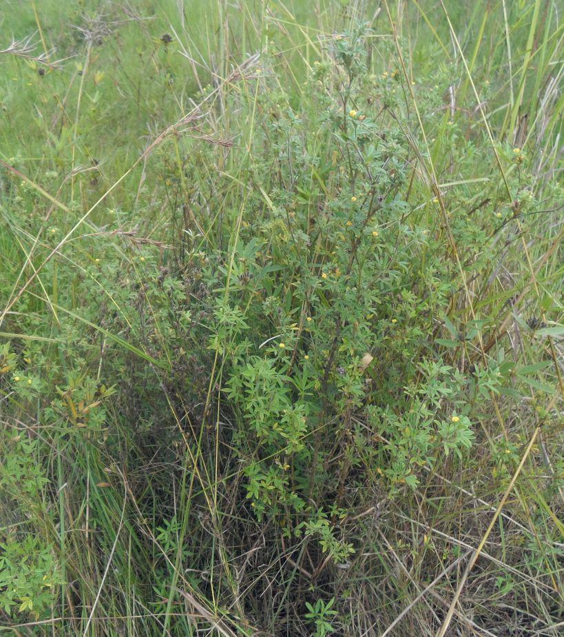
Area enclosure is done in low grazing range lands of average slope 2 – 5%. Enclosure is done by demarcating the fragile land that has direct impact to the riverine ecosystem. The land is exposed to degradation through overgrazing and soil compaction by livestock, bush fire, river bank erosion and reduced quality of pasture spps. Demarcation is done by planting trees in identified area situated about 300 meters from the riverine buffer zone. The preferred plants are Ficus thonigii. The average space between trees is 2 meters. Physical enclosure is supported and enhanced by use of protective bylaws. Reseeding of nutritious pasture species is also done and the area is left under protection for growth and regeneration of mulch, pastures and other vegetation to take place. The common pasture species reseeded are Leucaena spp, cannavaria brazile, clitoria tenatea, sesbania sesban, stylothensis, cajanus cajan, chloris gayana, branchalia spps . Direct grazing is prohibited and mulch and pasture materials are accessed through controlled and organized cut and carry.
Area enclosure is meant for rehabilitation of the riverine ecosystem and prevention of further degradation. Mulch and high nutritious pasture materials that are accessed through organized cut and carry procedures improve crop and animal productivity and have both direct and indirect impact to diversification of income sources and thus play significant role in putting the triple win solution into reality.
Purpose of the Technology: Purpose: 1) To improve vegetative cover, reduce soil erosion and prevent and rehabilitate degradation of the riverine ecosystem 2) Ensure sustainable availability and accessibility of mulch and nutritious pasture that are need for increased crop and livestock productivity 3) Promote use of environmental friendly exploitation of land resources (i.e. mulch, pasture, grass carpeting and other materials) and 4) Promote direct and indirect diversification of income sources.
Establishment / maintenance activities and inputs: Establishment and recurrent activities includes: area identification and measurement; slashing and land preparation for boundary tree planting and pasture reseeding; collection of planting materials and planting along defined boundaries for demarcation; procurement of seed and reseeding of nutritious and palatable pasture species; selective weeding; area reshaping and gap filling.
Natural / human environment: Bio-physically the area is semi natural grassland with grasses and shrubs trees. The technology is a combination of management and vegetative measure (area enclosure, demarcation using ficus thonigii and reseeding of nutritious pasture). Climatic zone is sub humid with 210 length of growing period (LGP). Slope category is gentle lying between 2-5%. Soil texture is fine heavy (clay) with medium soil depth.
Social economic wise the area is dominated by handy tools typology of mechanization. Production system is mixed (both for subsistence and commercial purposes). Inputs used includes tools (hand hoe, machete, sickles, spade and mattock), light and heavy labour, pasture seeds and tree planting materials with average annual costs of 1084.3 USD per hectare. Land ownership in technological area is communal.
2.3 Photos of the Technology
Media Gallery
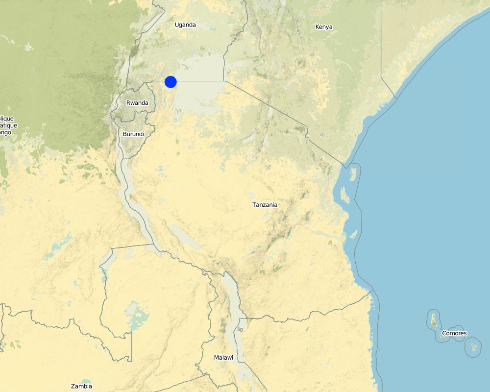
2.5 Country/ region/ locations where the Technology has been applied and which are covered by this assessment
Country:
Tanzania, United Republic of
Region/ State/ Province:
Tanzania/Kagera
Further specification of location:
Missenyi distict/Minziro ward/Minziro village
Specify the spread of the Technology:
- evenly spread over an area
If precise area is not known, indicate approximate area covered:
- < 0.1 km2 (10 ha)
Comments:
Includes enclosed and demarcated area closer and around the riverine ecosystem.
Map
×2.6 Date of implementation
If precise year is not known, indicate approximate date:
- less than 10 years ago (recently)
2.7 Introduction of the Technology
Specify how the Technology was introduced:
- through land users' innovation
- through projects/ external interventions
Comments (type of project, etc.):
The technology is a result of the recent SLM participatory dialogues made between land users and SLM specialist (external experts). In these dialogues both endogenous and technical knowledge based were given equal weight and were combined in a complementary manner. Land users alos were empowered to take self initiative and ownership of the decision making process.
3. Classification of the SLM Technology
3.1 Main purpose(s) of the Technology
- reduce, prevent, restore land degradation
- conserve ecosystem
- preserve/ improve biodiversity
3.2 Current land use type(s) where the Technology is applied
Land use mixed within the same land unit:
Yes
Specify mixed land use (crops/ grazing/ trees):
- Silvo-pastoralism

Cropland
Number of growing seasons per year:
- 2
Specify:
Longest growing period in days: 120, Longest growing period from month to month: September to December Second longest growing period in days: 90 Second longest growing period from month to month: March to May

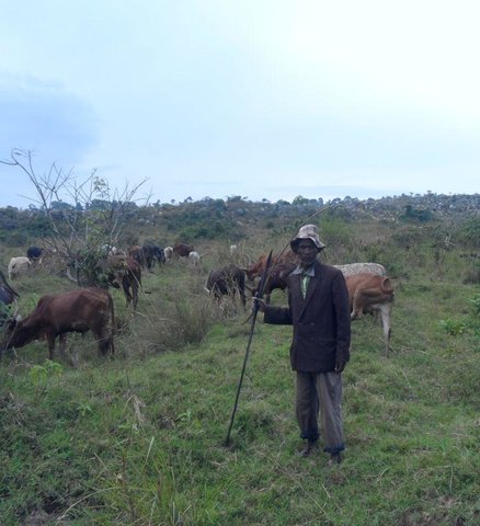
Grazing land
Extensive grazing:
- Nomadism
- Semi-nomadic pastoralism
Intensive grazing/ fodder production:
- Cut-and-carry/ zero grazing
Animal type:
- goats
- sheep

Forest/ woodlands
- Ficus thonigii
Comments:
Livestock density (if relevant):
50-100 LU /km2
Major land use problems (compiler’s opinion): Soil erosion due to downstream run off exacerbated by loss of vegetation cover due to bush fire and soil compaction caused by overgrazing, degradation of the riverine ecosystem caused by River bank erosion, land bareness and exposure to direct sunlight and excessive unproductive loss of both green and blue water.
Major land use problems (land users’ perception): River pollution, erosion of the river bank, land bareness and reduction of mulching and pasture materials.
Nomadism: People with large herd of animal move with their animals in search of adequate pasture
Semi-nomadism / pastoralism: Exercised with people with few stock.
Cut-and-carry/ zero grazing: done by farmers who usuall keep dairy goats and cattles.
Grazingland comments: Area enclosure is largely meant to control land degradation of the riverine ecosystem through overgrazing by people who own large number of stocks at the same time promote organized, sustainable and environmental friendly exploitation of the fragile land lands (e.g. controlled cut and carry rather than direct grazing in the riverine ecosystem).
3.4 Water supply
Water supply for the land on which the Technology is applied:
- rainfed
3.5 SLM group to which the Technology belongs
- area closure (stop use, support restoration)
3.6 SLM measures comprising the Technology

vegetative measures
- V2: Grasses and perennial herbaceous plants

management measures
- M7: Others
Comments:
Main measures: vegetative measures, management measures
Specification of other management measures: Area enclosure to promote vegetative regeneration and organized use
Type of vegetative measures: aligned: -along boundary, scattered / dispersed
3.7 Main types of land degradation addressed by the Technology

soil erosion by water
- Wr: riverbank erosion

physical soil deterioration
- Pc: compaction

biological degradation
- Bc: reduction of vegetation cover

water degradation
- Hs: change in quantity of surface water
Comments:
Main causes of degradation: soil management (Compaction due to overstocking, accerated runoff and erosion.), crop management (annual, perennial, tree/shrub) (Reduction of mulching and pasture materials), deforestation / removal of natural vegetation (incl. forest fires) (Rampant bush fire), over-exploitation of vegetation for domestic use (Un0rganize exploitation of mulching materials), overgrazing (Uncontrolled grazing), disturbance of water cycle (infiltration / runoff) (Loss of green water through unproductive evaporation and blue water through ruoff as well as evaporation), population pressure (Exessive eploitation of the grassland and forests in the riverine ecosystem), poverty / wealth (Reliance on wood as the sole source of fuel), education, access to knowledge and support services (Inadequate acess to extension service due to shortage of extension staff), governance / institutional (Weak and inactive institutions to deal with environmental issues)
Secondary causes of degradation: change in temperature (Climatic change and variability due to green gas emmision caused by bush fire), change of seasonal rainfall (Climatic change and variability due to green gas emmision caused by bush fire), Heavy / extreme rainfall (intensity/amounts) (Climatic change and variability due to green gas emmision caused by bush fire), droughts (Climatic change and variability due to green gas emmision caused by bush fire)
3.8 Prevention, reduction, or restoration of land degradation
Specify the goal of the Technology with regard to land degradation:
- reduce land degradation
- restore/ rehabilitate severely degraded land
4. Technical specifications, implementation activities, inputs, and costs
4.1 Technical drawing of the Technology
Technical specifications (related to technical drawing):
Technical knowledge required for field staff / advisors: moderate (Is simply retraining on some principles of sustainable land management, law and rules guiding the fragile ecosystems, participatory training skills and grassroots facilitation skills.)
Technical knowledge required for land users: moderate (Largely exposure to act and policies guiding the fragile ecosystems and learning by doing on the job,)
Main technical functions: control of raindrop splash, control of dispersed runoff: impede / retard, control of concentrated runoff: impede / retard, improvement of ground cover, improvement of topsoil structure (compaction), stabilisation of soil (eg by tree roots against land slides), increase / maintain water stored in soil, improvement of water quality, buffering / filtering water, sediment retention / trapping, sediment harvesting, promotion of vegetation species and varieties (quality, eg palatable fodder)
Aligned: -along boundary
Vegetative material: T : trees / shrubs
Number of plants per (ha): 400
Vertical interval between rows / strips / blocks (m): 1 m
Spacing between rows / strips / blocks (m): 1 m
Vertical interval within rows / strips / blocks (m): 1 m
Width within rows / strips / blocks (m): 1 m
Scattered / dispersed
Vegetative material: T : trees / shrubs, G : grass
Number of plants per (ha): various
Vertical interval between rows / strips / blocks (m): various
Spacing between rows / strips / blocks (m): various
Vertical interval within rows / strips / blocks (m): various
Width within rows / strips / blocks (m): various
Trees/ shrubs species: ficus thonigii planted arround the boundary and leguminous pasture shrubs planted within the area (stlothensis, lucaena spps)
Grass species: Randomly planted (chloris gayana, desmodium spp and Calliandra)
Slope (which determines the spacing indicated above): 2 - 5%%
Gradient along the rows / strips: 2 - 5%%
Change of land use practices / intensity level: Introduction of organized cut and carry exploitation of mulching and pasture materials
Other type of management: Boundary enclosure, law enforcement
4.2 General information regarding the calculation of inputs and costs
other/ national currency (specify):
Tanzanian shillings
If relevant, indicate exchange rate from USD to local currency (e.g. 1 USD = 79.9 Brazilian Real): 1 USD =:
1700.0
Indicate average wage cost of hired labour per day:
1.12
4.3 Establishment activities
| Activity | Timing (season) | |
|---|---|---|
| 1. | Site/boundary identification | October |
| 2. | Site preparation for reseeding and demarcation (slashing, selective tilling, hole digging) | October |
| 3. | Planting of demarcation trees, leguminous shrubs and grass pasture | November |
| 4. | Fertilizer application (DAP) | Once |
| 5. | Meeting on awareness creation and formalization of the practice (change of resource use practice) | once |
4.4 Costs and inputs needed for establishment
| Specify input | Unit | Quantity | Costs per Unit | Total costs per input | % of costs borne by land users | |
|---|---|---|---|---|---|---|
| Labour | Site/boundary identification | Mandays | 15.0 | 1.13333 | 17.0 | 100.0 |
| Labour | Site preparation for reseeding and demarcation (slashing, selective tilling, hole digging) | Mandays | 15.0 | 3.9213 | 58.82 | |
| Labour | Planting of demarcation trees, leguminous shrubs and grass pasture | Mandays | 15.0 | 3.9213 | 58.82 | |
| Labour | Fertilizer application (DAP) | Mandays | 15.0 | 1.13333 | 17.0 | |
| Equipment | Tools | Number | 5.0 | 3.0 | 15.0 | 100.0 |
| Plant material | Seeds | ha | 1.0 | 235.29 | 235.29 | |
| Plant material | Seedlings | ha | 1.0 | 117.65 | 117.65 | |
| Fertilizers and biocides | Fertilizer | kg | 125.0 | 0.588 | 73.5 | |
| Other | Meeting on awareness creation and formalization of the practice (change of resource use practice) | Mandays | 15.0 | 3.9213 | 58.82 | 100.0 |
| Total costs for establishment of the Technology | 651.9 | |||||
| Total costs for establishment of the Technology in USD | 0.38 | |||||
Comments:
Duration of establishment phase: 2 month(s)
4.5 Maintenance/ recurrent activities
| Activity | Timing/ frequency | |
|---|---|---|
| 1. | Selective weeding and gap filling | Once |
| 2. | Supervision and monitoring | monthly |
| 3. | Organized cut and carry of Mulching and pasture materials | Weekly |
| 4. | monitoring area closure and organized cut and carry | Weekly |
4.6 Costs and inputs needed for maintenance/ recurrent activities (per year)
| Specify input | Unit | Quantity | Costs per Unit | Total costs per input | % of costs borne by land users | |
|---|---|---|---|---|---|---|
| Labour | Selective weeding and gap filling | Mandays | 15.0 | 1.76466 | 26.47 | 100.0 |
| Labour | Supervision and monitoring | Mandays | 15.0 | 3.53 | 52.95 | 100.0 |
| Labour | Organized cut and carry of Mulching and pasture materials | Mandays | 10.0 | 17.647 | 176.47 | 100.0 |
| Labour | monitoring area closure and organized cut and carry | Mandays | 10.0 | 17.647 | 176.47 | 100.0 |
| Total costs for maintenance of the Technology | 432.36 | |||||
| Total costs for maintenance of the Technology in USD | 0.25 | |||||
Comments:
Machinery/ tools: machete and sickles.
The costs were calculated per unit of ha as per 13/06/2014.
4.7 Most important factors affecting the costs
Describe the most determinate factors affecting the costs:
labour is the most determinant factor.
5. Natural and human environment
5.1 Climate
Annual rainfall
- < 250 mm
- 251-500 mm
- 501-750 mm
- 751-1,000 mm
- 1,001-1,500 mm
- 1,501-2,000 mm
- 2,001-3,000 mm
- 3,001-4,000 mm
- > 4,000 mm
Specifications/ comments on rainfall:
Short rains (september to December), March to May long rains. Length of dry periods January, February, June, July and August.
Agro-climatic zone
- sub-humid
Thermal climate class: tropics. Temperature grater than 20°C, LGP is 210 days
5.2 Topography
Slopes on average:
- flat (0-2%)
- gentle (3-5%)
- moderate (6-10%)
- rolling (11-15%)
- hilly (16-30%)
- steep (31-60%)
- very steep (>60%)
Landforms:
- plateau/plains
- ridges
- mountain slopes
- hill slopes
- footslopes
- valley floors
Altitudinal zone:
- 0-100 m a.s.l.
- 101-500 m a.s.l.
- 501-1,000 m a.s.l.
- 1,001-1,500 m a.s.l.
- 1,501-2,000 m a.s.l.
- 2,001-2,500 m a.s.l.
- 2,501-3,000 m a.s.l.
- 3,001-4,000 m a.s.l.
- > 4,000 m a.s.l.
Comments and further specifications on topography:
Landforms: Plateau/plains (ranked 1, is largely applied in extended cancave lower range land pouring water to the river) and footslopes (ranked 2, partly includes the convex the convex hill slopes)
Slopes on average: Gentle (The area is largely extended gentle sloppy lower range land plateau receiving water from the the upper landscape and draining into the lower Ngono river which drains into Kagera river)
5.3 Soils
Soil depth on average:
- very shallow (0-20 cm)
- shallow (21-50 cm)
- moderately deep (51-80 cm)
- deep (81-120 cm)
- very deep (> 120 cm)
Soil texture (topsoil):
- coarse/ light (sandy)
- fine/ heavy (clay)
Topsoil organic matter:
- low (<1%)
If available, attach full soil description or specify the available information, e.g. soil type, soil PH/ acidity, Cation Exchange Capacity, nitrogen, salinity etc.
Soil depth on average: Moderately deep (ranked 1, The lower range land is moderately deep it receives eroded soil from the upper and mid sloppy landscape) and shallow (ranked 2, largely include the the area between the upper and lower mid landscape)
Soil texture: Coarse/light (ranked 1, the lower side is largely light sandy soil) and fine/heavy (ranked 2, some patches fine clay soil)
Soil fertility: Low (Nutrient eroded by runoff into the river)
Topsoil organic matter: Low (top soil eroded by runoff into the river)
Soil drainage / infiltration: Medium (ranked 1, caused by the dominance of sand soil) and poor (ranked 2, due to trampling by animals)
Soil water storage capacity: Low (due to the dominance of sand soil)
5.4 Water availability and quality
Ground water table:
on surface
Availability of surface water:
medium
Water quality (untreated):
poor drinking water (treatment required)
Comments and further specifications on water quality and quantity:
Ground water table: On surface (ranked 1, along the flowing river Ngono) and <5m (ranked 2, the area is within the riverine ecosystem)
Availability of surface water: Medium (The main water source is Kagera river with water flows all year round)
Water quality (untreated): Poor drinking water (treatment required, Kagera river receives partly receives water drained from the upper kibanja, Kikamba and other distant places. Kagera river water therefore is contaminated can not be consumed untreated)
5.5 Biodiversity
Species diversity:
- low
Comments and further specifications on biodiversity:
Overgrazing has left the area with disappearance of some palatable and nutritious pastures, bushfire and deforestation also has disturbed tree and shrub composition and the soil microbiology.
5.6 Characteristics of land users applying the Technology
Market orientation of production system:
- mixed (subsistence/ commercial)
Off-farm income:
- less than 10% of all income
Individuals or groups:
- individual/ household
Gender:
- women
- men
Indicate other relevant characteristics of the land users:
Land users applying the Technology are mainly common / average land users
Population density: 50-100 persons/km2
Annual population growth: 1% - 2%
30% of the land users are very rich and own 35% of the land.
60% of the land users are average wealthy and own 50% of the land.
10% of the land users are poor.
and own 15% of the land.
Off-farm income specification: Generally 90% relies on agriculture as their main source of livelihood. Only a few are engaged in off-farm activities like petty trading, kiosk, brick making e.t.c.
Market orientation: Mixed (Livestock are largely kept for domestic use e.g. milk, meat and manure and parlty for commercial purposes)
5.7 Average area of land used by land users applying the Technology
- < 0.5 ha
- 0.5-1 ha
- 1-2 ha
- 2-5 ha
- 5-15 ha
- 15-50 ha
- 50-100 ha
- 100-500 ha
- 500-1,000 ha
- 1,000-10,000 ha
- > 10,000 ha
Is this considered small-, medium- or large-scale (referring to local context)?
- small-scale
Comments:
There is shortage of grazing land. People with large animal herd move with their animals in search of better pasture.
5.8 Land ownership, land use rights, and water use rights
Land ownership:
- individual, not titled
Land use rights:
- individual
Water use rights:
- open access (unorganized)
Comments:
In Tanzania land is a state property. Land use right is largely individual not titled and is acquired through inheritance or purchase through traditional or customary procedures.
5.9 Access to services and infrastructure
health:
- poor
- moderate
- good
education:
- poor
- moderate
- good
technical assistance:
- poor
- moderate
- good
employment (e.g. off-farm):
- poor
- moderate
- good
markets:
- poor
- moderate
- good
roads and transport:
- poor
- moderate
- good
drinking water and sanitation:
- poor
- moderate
- good
financial services:
- poor
- moderate
- good
6. Impacts and concluding statements
6.1 On-site impacts the Technology has shown
Socio-economic impacts
Production
crop production
Quantity before SLM:
5.0 ton/ha
Quantity after SLM:
6-7.0 ton/ha
Comments/ specify:
due to the availability and use of mulching by some farmersmaterials
fodder production
Quantity before SLM:
2 acres/annum
Quantity after SLM:
10 acre/annum
Comments/ specify:
area enclosure and decline of forest fire
fodder quality
Quantity before SLM:
3
Quantity after SLM:
8
Comments/ specify:
increase in the number of nutritiuos pasture species due to reseeding
animal production
Quantity before SLM:
1200litres/cow/yeer
Quantity after SLM:
2000litres/cow/year
Comments/ specify:
Contribution of nutritious cut and carry pastures
Income and costs
expenses on agricultural inputs
Quantity before SLM:
high
Quantity after SLM:
low
Comments/ specify:
availability of manure from animal kept under zore grazing
diversity of income sources
Quantity before SLM:
low
Quantity after SLM:
high
Comments/ specify:
Income accrued from sell of mulching and pasture materials.
Socio-cultural impacts
food security/ self-sufficiency
Quantity before SLM:
low
Quantity after SLM:
high
Comments/ specify:
improved diet due to varied food availability (avalability of milk)
community institutions
Quantity before SLM:
weak
Quantity after SLM:
strong
Comments/ specify:
empowerment and capacity building of environmental committee.
SLM/ land degradation knowledge
Quantity before SLM:
low
Quantity after SLM:
high
Comments/ specify:
Knoledge over controll of riverine resources.
conflict mitigation
Quantity before SLM:
low
Quantity after SLM:
high
Improved livelihoods and human well-being
Comments/ specify:
The technology has contributed to availability and accessibility to mulching and nutritious pasture that are need for increased crop and livestock productivity. This has both direct and indirect impact on the income of the community and hence livelihood (e.g. ability to meet education and health expenses).
Ecological impacts
Water cycle/ runoff
water quantity
Quantity before SLM:
low
Quantity after SLM:
high
Comments/ specify:
Reduction in uproductive loss of both green and blue water.
surface runoff
Quantity before SLM:
high
Quantity after SLM:
low
Comments/ specify:
Resultant of vergetation cover
evaporation
Quantity before SLM:
high
Quantity after SLM:
low
Comments/ specify:
Reduce uproductive evaporation due vegetation cover
Soil
soil cover
Quantity before SLM:
low
Quantity after SLM:
high
Comments/ specify:
Improved vegetation cover
soil loss
Quantity before SLM:
high
Quantity after SLM:
low
Comments/ specify:
Cotrolled soil erosion due to runoff
soil crusting/ sealing
Quantity before SLM:
high
Quantity after SLM:
low
Comments/ specify:
Reduced overgrazing and animla trumpling
soil compaction
Quantity before SLM:
high
Quantity after SLM:
low
Comments/ specify:
Reduced overgrazing and animla trumpling
Biodiversity: vegetation, animals
biomass/ above ground C
Quantity before SLM:
low
Quantity after SLM:
high
Comments/ specify:
Controlled fire burning
Climate and disaster risk reduction
emission of carbon and greenhouse gases
Quantity before SLM:
high
Quantity after SLM:
low
Comments/ specify:
Controled bush fire
fire risk
Quantity before SLM:
high
Quantity after SLM:
low
Comments/ specify:
harzards due to bush fire but reduced due to enclosure, fire break and use of bylaws.
6.2 Off-site impacts the Technology has shown
downstream siltation
Quantity before SLM:
high
Quantity after SLM:
low
Comments/ specify:
Resultant of improved vegetation cover and controlled erosion
groundwater/ river pollution
Quantity before SLM:
high
Quantity after SLM:
low
Comments/ specify:
Resultant of improved vegetation cover and controlled erosion
6.3 Exposure and sensitivity of the Technology to gradual climate change and climate-related extremes/ disasters (as perceived by land users)
Gradual climate change
Gradual climate change
| Season | increase or decrease | How does the Technology cope with it? | |
|---|---|---|---|
| annual temperature | increase | well |
Climate-related extremes (disasters)
Meteorological disasters
| How does the Technology cope with it? | |
|---|---|
| local rainstorm | not known |
| local windstorm | not known |
Climatological disasters
| How does the Technology cope with it? | |
|---|---|
| drought | not well |
Hydrological disasters
| How does the Technology cope with it? | |
|---|---|
| general (river) flood | not known |
Other climate-related consequences
Other climate-related consequences
| How does the Technology cope with it? | |
|---|---|
| reduced growing period | not well |
Comments:
The technology was modified to become more tolerant through organized cut and carry of mulching and pasture materials.
6.4 Cost-benefit analysis
How do the benefits compare with the establishment costs (from land users’ perspective)?
Short-term returns:
slightly positive
Long-term returns:
positive
How do the benefits compare with the maintenance/ recurrent costs (from land users' perspective)?
Short-term returns:
slightly positive
Long-term returns:
positive
Comments:
Mulching and pasture have short maturing period and this causes land users to realize rewards right from the beginning of the technology and the benefit increases more with time.
6.5 Adoption of the Technology
Comments:
Comments on acceptance with external material support: The technology is applied only on communally owned area nearby the fragile reverine ecosystem. Implementation is done by empowered community based on and guided with decision reached by the whole community and law reinforcement. Is not based on individual voluntarism and option.
Comments on spontaneous adoption: The technology is applied only on communally owned area nearby the fragile reverine ecosystem. Implementation is done by empowered community based on and guided with decision reached by the whole community and law reinforcement. Is not based on individual voluntarism and option.
There is a strong trend towards spontaneous adoption of the Technology
Comments on adoption trend: As a result of benefit realization of the use of technology, there a growing acceptance and spontaneous adoption by the whole community
6.7 Strengths/ advantages/ opportunities of the Technology
| Strengths/ advantages/ opportunities in the land user’s view |
|---|
| The technology prevent degradation of the river bank and disappearance of palatable and nutritious pasture |
| Strengths/ advantages/ opportunities in the compiler’s or other key resource person’s view |
|---|
| Area enclosure complimented with reinforcement of bylaws reduce fire incidences and helps in sequestration of carbon both above and below the ground and reduce the effect of green gas emission. |
| Area enclosure and organized cut and carry feeding ensure availability of feed to animals kept in farm under zero grazing (e.g. dairy goats and cattle) and control unproductive loss of manure. |
| Area enclosure and organized cut and carry feeding ensure availability of mulching materials needed in production of banana and other crops. |
| Promote direct and indirect diversification of income sources to the rural poor. |
6.8 Weaknesses/ disadvantages/ risks of the Technology and ways of overcoming them
| Weaknesses/ disadvantages/ risks in the land user’s view | How can they be overcome? |
|---|---|
| Time consuming and labour heavy especially to environmental committee members. | Device motivation and incentive system at the grassroots. |
| Weaknesses/ disadvantages/ risks in the compiler’s or other key resource person’s view | How can they be overcome? |
|---|---|
| Emergency and dominance of invasive species | Liaise with research to find alternative and beneficial use of invasive species. |
| Needs committed people who can spend their valuable time in promotion of the technology. | Use SLM related incentives and promotion e.g. support with dairy goat to people who actively participate in promotion of the technology (as part of crop livestock integration) . |
| Takes time to inculcate self initiatives and ownership | Systematize and Operationalize into existing systems |
| Needs attitude and behavioral change (is not normal traditional for rural people to cultivate grass). | Encourage change of mindset by enabling farmers understanding of the principle behind pasture establishment. |
7. References and links
7.1 Methods/ sources of information
- field visits, field surveys
- interviews with land users
When were the data compiled (in the field)?
03/06/2014
Links and modules
Expand all Collapse allLinks
Active participation of herder leader (WAKONDO) in management … [Tanzania, United Republic of]
Prevention and mitigation of the grazing land and riverine ecosystems through mandatory grassroots meetings, law enforcement and active participation and empowerment of herder leaders’ (masters of the most resource destructive group)
- Compiler: ALLAN BUBELWA
Modules
No modules