Sand dune stabilisation [Niger]
- Creation:
- Update:
- Compiler: Dieter Nill
- Editor: –
- Reviewers: Fabian Ottiger, Alexandra Gavilano
Fixation des dunes (French)
technologies_1620 - Niger
View sections
Expand all Collapse all1. General information
1.2 Contact details of resource persons and institutions involved in the assessment and documentation of the Technology
SLM specialist:
Dorlöchter-Sulser Sabine
Misereor
Germany
SLM specialist:
Mamadou Abdou Sani
Programme d’Appui à l’agriculture Productive (PROMAP)/GIZ
Niger
Name of project which facilitated the documentation/ evaluation of the Technology (if relevant)
Manual of Good Practices in Small Scale Irrigation in the Sahel (GIZ )Name of the institution(s) which facilitated the documentation/ evaluation of the Technology (if relevant)
Deutsche Gesellschaft für Internationale Zusammenarbeit (GIZ) - GermanyName of the institution(s) which facilitated the documentation/ evaluation of the Technology (if relevant)
Misereor - Germany1.3 Conditions regarding the use of data documented through WOCAT
The compiler and key resource person(s) accept the conditions regarding the use of data documented through WOCAT:
Yes
1.4 Declaration on sustainability of the described Technology
Is the Technology described here problematic with regard to land degradation, so that it cannot be declared a sustainable land management technology?
No
1.5 Reference to Questionnaire(s) on SLM Approaches (documented using WOCAT)
Participatory land rehabilitation [Niger]
Planning and management of individual and village land, based on land users' participation, with simultaneous promotion of women's activities.
- Compiler: Eric Tielkes
2. Description of the SLM Technology
2.1 Short description of the Technology
Definition of the Technology:
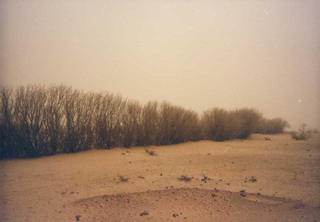
Sand dunes are stabilized with vegetation to reduce wind erosion and the amount of sand blown onto cropland, dwellings and other infrastructure.
2.2 Detailed description of the Technology
Description:
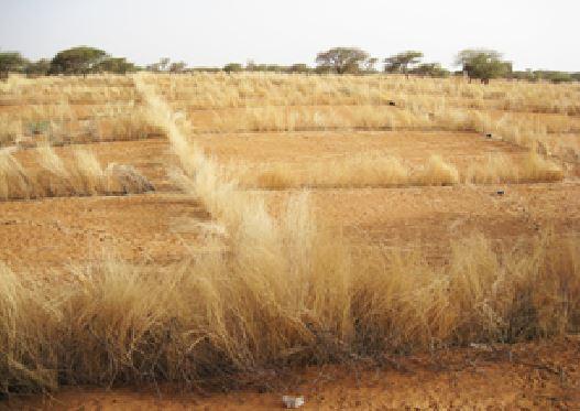
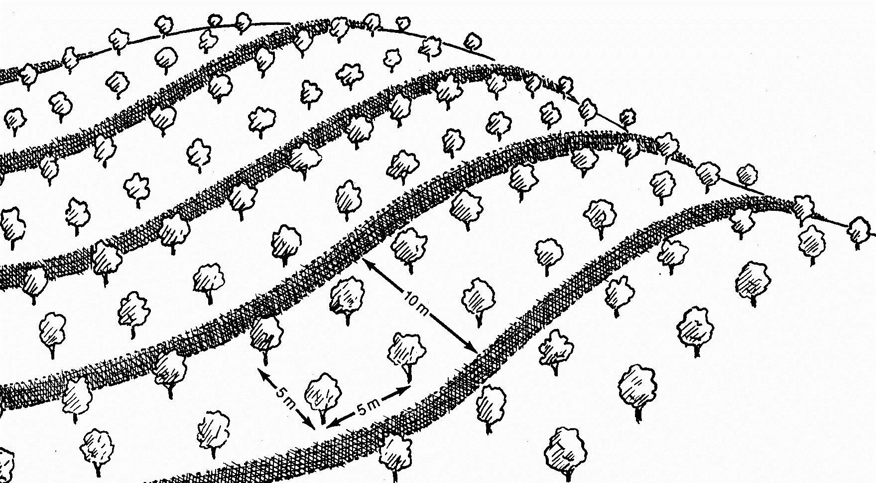
This measure is used to stabilise sand dunes in locations and villages where there is a risk of sand covering cropland or infrastructure (buildings, roads, irrigation systems, etc.). Dune stabilisation is achieved by setting up windbreaks arranged in a checkerboard pattern, with each side measuring between 10 and 15 m. The windbreaks are formed by palisades made from millet stalks or other plant material or by hedges and trees (Leptadenia pyrotechnica, Euphorbia balsamifera, Acacia raddiana, Acacia senegal, Balanites aegyptiaca, Prosopis juliflora, etc.).
Purpose of the Technology: They provide protection from wind erosion and reduce the amount of sand blown onto cropland, dwellings and other infrastructure which can prevent extensive damage. Grass and shrubs are planted in strips in the fenced-off areas to further stabilise the soil. The palisades and vegetation provide shade that lowers soil temperatures and the organic matter and waste improves the soil structure.
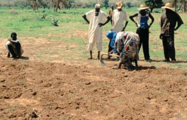
Establishment / maintenance activities and inputs: Specific experience is required to assess the degraded area as a whole and choose the most appropriate techniques, the right species to plant and the most suitable locations. Sometimes, the protected area is rehabilitated, particularly when land use pressure is high in neighbouring areas.
The protected dunes must be closely monitored and rigorously maintained for at least three years. It is therefore necessary to ensure good community organisation and take the action required to enforce the rules established and impose fines. Partial use of the area for grazing is sometimes allowed (one day a fortnight). Some projects prefer to fence off the sites with wire fencing to ensure that they are completely protected.
The success of this measure depends to a large extent on climatic conditions. A rainy year after the windbreaks have been erected creates favourable conditions for the species planted to become established.
Natural / human environment: With increasingly stronger winds and the accelerated degradation of the natural vegetation growing on sand dunes, it is very likely that the problems caused by shifting dunes will worsen in the future. Techniques to stabilise shifting sand dunes will therefore become more important.
2.3 Photos of the Technology
Media Gallery
2.5 Country/ region/ locations where the Technology has been applied and which are covered by this assessment
Country:
Niger
Region/ State/ Province:
Niger
Specify the spread of the Technology:
- evenly spread over an area
If the Technology is evenly spread over an area, specify area covered (in km2):
1.8
If precise area is not known, indicate approximate area covered:
- 1-10 km2
Comments:
Total area covered by the SLM Technology is 1.8 km2.
Under the PDRT in Niger, a total area of 180 ha of shifting sand dunes was stabilised, preventing serious damage to dwellings and to the farmland and rangeland that are basic components of the population’s livelihood system.
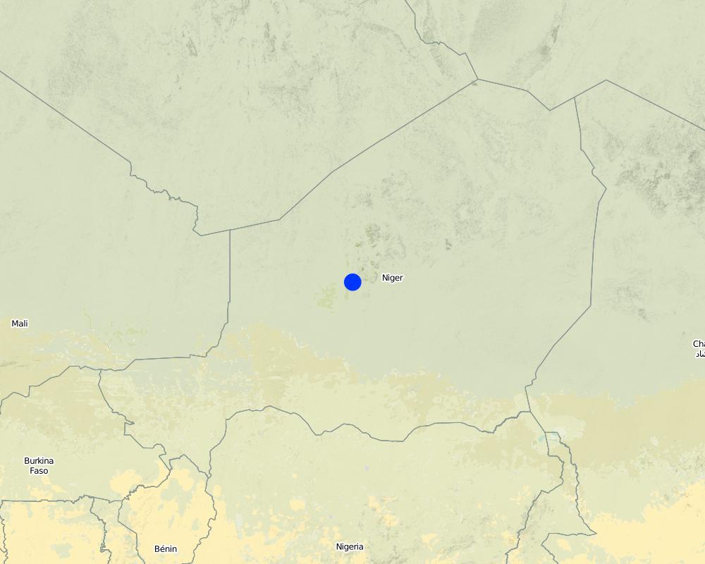
Map
×2.6 Date of implementation
If precise year is not known, indicate approximate date:
- 10-50 years ago
2.7 Introduction of the Technology
Specify how the Technology was introduced:
- through projects/ external interventions
Comments (type of project, etc.):
developed, implemented and disseminated as part of projects and programmes undertaken from the 1980s onwards to combat desertification and improve natural resource management. Implemented by GIZ (German Federal Enterprise for International Cooperation), PDRT (Projet de développement rural de Tahoua - Tahoua Rural Development Project), PASP (Projet de protection intégrée des ressources agro-sylvo-pastorales Tillabéri-Nord - Project for the Integrated Protection of Agricultural, Forest and Rangeland Resources in Tillabéri-Nord)
3. Classification of the SLM Technology
3.1 Main purpose(s) of the Technology
- reduce, prevent, restore land degradation
- conserve ecosystem
- adapt to climate change/ extremes and its impacts
3.2 Current land use type(s) where the Technology is applied

Cropland
- Annual cropping
Number of growing seasons per year:
- 1
Specify:
Longest growing period in days: 120, Longest growing period from month to month: August to October

Grazing land
Comments:
Major land use problems (compiler’s opinion): wind erosion
Constraints of common grazing land
Constraints of forested government-owned land or commons
3.5 SLM group to which the Technology belongs
- windbreak/ shelterbelt
3.6 SLM measures comprising the Technology

vegetative measures
- V1: Tree and shrub cover
- V2: Grasses and perennial herbaceous plants
Comments:
Type of vegetative measures: aligned: -against wind
3.7 Main types of land degradation addressed by the Technology

soil erosion by wind
- Et: loss of topsoil
- Ed: deflation and deposition
- Eo: offsite degradation effects

chemical soil deterioration
- Cn: fertility decline and reduced organic matter content (not caused by erosion)
Comments:
Main causes of degradation: soil management (Unadapted landuse methods, reduced or abandoned fallow periods), droughts, population pressure (rapidly growing population increasing pressure on land), land tenure (insecure access to land)
3.8 Prevention, reduction, or restoration of land degradation
Specify the goal of the Technology with regard to land degradation:
- prevent land degradation
- reduce land degradation
4. Technical specifications, implementation activities, inputs, and costs
4.1 Technical drawing of the Technology
Technical specifications (related to technical drawing):
Dune stabilisation is achieved by setting up windbreaks arranged in a checkerboard pattern, with each side measuring between 10 and 15 m. The windbreaks are formed by palisades made from millet stalks or other plant material or by hedges and trees.
Location: Niger
Technical knowledge required for field staff / advisors: moderate
Technical knowledge required for land users: low
Main technical functions: improvement of ground cover, increase of surface roughness, stabilisation of soil (eg by tree roots against land slides), sediment retention / trapping, sediment harvesting, reduction in wind speed, increase of biomass (quantity), promotion of vegetation species and varieties (quality, eg palatable fodder)
Aligned: -against wind
Vegetative material: T : trees / shrubs, G : grass
Number of plants per (ha): 400
Spacing between rows / strips / blocks (m): 10
Vertical interval within rows / strips / blocks (m): 5
Trees/ shrubs species: Prosopis chilensis, Ziziphus mauritiana, Acacia senegal, Bauhina rufescens, Euphorbia balsamifera.
4.2 General information regarding the calculation of inputs and costs
other/ national currency (specify):
CFA Franc
If relevant, indicate exchange rate from USD to local currency (e.g. 1 USD = 79.9 Brazilian Real): 1 USD =:
521.18
4.3 Establishment activities
| Activity | Timing (season) | |
|---|---|---|
| 1. | Establish palisade of millet stalk | |
| 2. | Seeding grasses | |
| 3. | Planting | |
| 4. | Spreading manure |
4.4 Costs and inputs needed for establishment
| Specify input | Unit | Quantity | Costs per Unit | Total costs per input | % of costs borne by land users | |
|---|---|---|---|---|---|---|
| Labour | Labour | ha | 1.0 | 96.45 | 96.45 | |
| Plant material | Seedlings | ha | 1.0 | 212.2 | 212.2 | |
| Other | Transport | ha | 1.0 | 115.75 | 115.75 | |
| Total costs for establishment of the Technology | 424.4 | |||||
| Total costs for establishment of the Technology in USD | 0.81 | |||||
4.7 Most important factors affecting the costs
Describe the most determinate factors affecting the costs:
Labour: 50 man-days per ha
• 60 palisade stakes per ha
• 400 tree and shrub seedlings per ha
• transportation (by lorry) of palisades and seedlings
• protection: costly if the site is protected with wire fencing, which might be stolen.
5. Natural and human environment
5.1 Climate
Annual rainfall
- < 250 mm
- 251-500 mm
- 501-750 mm
- 751-1,000 mm
- 1,001-1,500 mm
- 1,501-2,000 mm
- 2,001-3,000 mm
- 3,001-4,000 mm
- > 4,000 mm
Agro-climatic zone
- semi-arid
Thermal climate class: subtropics
5.2 Topography
Slopes on average:
- flat (0-2%)
- gentle (3-5%)
- moderate (6-10%)
- rolling (11-15%)
- hilly (16-30%)
- steep (31-60%)
- very steep (>60%)
Landforms:
- plateau/plains
- ridges
- mountain slopes
- hill slopes
- footslopes
- valley floors
Altitudinal zone:
- 0-100 m a.s.l.
- 101-500 m a.s.l.
- 501-1,000 m a.s.l.
- 1,001-1,500 m a.s.l.
- 1,501-2,000 m a.s.l.
- 2,001-2,500 m a.s.l.
- 2,501-3,000 m a.s.l.
- 3,001-4,000 m a.s.l.
- > 4,000 m a.s.l.
5.3 Soils
Soil depth on average:
- very shallow (0-20 cm)
- shallow (21-50 cm)
- moderately deep (51-80 cm)
- deep (81-120 cm)
- very deep (> 120 cm)
Soil texture (topsoil):
- medium (loamy, silty)
- fine/ heavy (clay)
If available, attach full soil description or specify the available information, e.g. soil type, soil PH/ acidity, Cation Exchange Capacity, nitrogen, salinity etc.
Soil fertility: Medium and low
Soil drainage/infiltration: Medium and poor
Soil water storage capacity: Medium and low
5.4 Water availability and quality
Ground water table:
5-50 m
Availability of surface water:
medium
5.5 Biodiversity
Species diversity:
- low
5.6 Characteristics of land users applying the Technology
Relative level of wealth:
- very poor
- poor
Gender:
- men
Indicate other relevant characteristics of the land users:
Population density: 10-50 persons/km2
Annual population growth: 3% - 4% (mostly poor households below poverty line).
Off-farm income specification: men migrate temporarily or permanently to cities for off-farm income
5.7 Average area of land used by land users applying the Technology
- < 0.5 ha
- 0.5-1 ha
- 1-2 ha
- 2-5 ha
- 5-15 ha
- 15-50 ha
- 50-100 ha
- 100-500 ha
- 500-1,000 ha
- 1,000-10,000 ha
- > 10,000 ha
Is this considered small-, medium- or large-scale (referring to local context)?
- small-scale
5.8 Land ownership, land use rights, and water use rights
Land ownership:
- state
Land use rights:
- communal (organized)
Water use rights:
- communal (organized)
Comments:
traditional land use rights on fields, communal land on pasture and forest land
5.9 Access to services and infrastructure
health:
- poor
- moderate
- good
education:
- poor
- moderate
- good
technical assistance:
- poor
- moderate
- good
employment (e.g. off-farm):
- poor
- moderate
- good
markets:
- poor
- moderate
- good
energy:
- poor
- moderate
- good
roads and transport:
- poor
- moderate
- good
drinking water and sanitation:
- poor
- moderate
- good
financial services:
- poor
- moderate
- good
6. Impacts and concluding statements
6.1 On-site impacts the Technology has shown
Socio-economic impacts
Production
fodder production
animal production
Comments/ specify:
Restrictions for grazing in the first three years
production area
Socio-cultural impacts
food security/ self-sufficiency
SLM/ land degradation knowledge
Improved livelihoods and human well-being
Comments/ specify:
Sometimes, the protected area is rehabilitated, particularly when land use pressure is high in neighbouring areas. They provide protection from wind erosion and reduce the amount of sand blown onto cropland, dwellings and other infrastructure which can prevent extensive damage.
Ecological impacts
Soil
soil cover
soil loss
Biodiversity: vegetation, animals
plant diversity
habitat diversity
Climate and disaster risk reduction
wind velocity
6.2 Off-site impacts the Technology has shown
wind transported sediments
damage on neighbours' fields
damage on public/ private infrastructure
6.3 Exposure and sensitivity of the Technology to gradual climate change and climate-related extremes/ disasters (as perceived by land users)
Gradual climate change
Gradual climate change
| Season | increase or decrease | How does the Technology cope with it? | |
|---|---|---|---|
| annual temperature | increase | well |
Climate-related extremes (disasters)
Meteorological disasters
| How does the Technology cope with it? | |
|---|---|
| local rainstorm | well |
| local windstorm | well |
Climatological disasters
| How does the Technology cope with it? | |
|---|---|
| drought | well |
Hydrological disasters
| How does the Technology cope with it? | |
|---|---|
| general (river) flood | well |
Other climate-related consequences
Other climate-related consequences
| How does the Technology cope with it? | |
|---|---|
| reduced growing period | well |
6.4 Cost-benefit analysis
How do the benefits compare with the establishment costs (from land users’ perspective)?
Short-term returns:
positive
Long-term returns:
positive
How do the benefits compare with the maintenance/ recurrent costs (from land users' perspective)?
Short-term returns:
positive
Long-term returns:
very positive
6.5 Adoption of the Technology
Comments:
There is a little trend towards spontaneous adoption of the Technology. With increasingly stronger winds and the accelerated degradation of the natural vegetation growing on sand dunes, it is very likely that the problems caused by shifting dunes will worsen in the future. Techniques to stabilise shifting sand dunes will therefore become more important.
6.7 Strengths/ advantages/ opportunities of the Technology
| Strengths/ advantages/ opportunities in the compiler’s or other key resource person’s view |
|---|
| Protection of infrastructure, cropland and rangeland |
| The palisades and vegetation used to stabilise sand dunes contribute to reducing wind erosion, and the shade that they provide lowers soil temperatures. The protection they provide for farmland and infrastructure can prevent extensive damage. |
| Once the surface of the dune has been stabilised with vegetation, the effect is lasting, provided that the area is not overgrazed. |
6.8 Weaknesses/ disadvantages/ risks of the Technology and ways of overcoming them
| Weaknesses/ disadvantages/ risks in the compiler’s or other key resource person’s view | How can they be overcome? |
|---|---|
| Grazing restrictions may reduce animal production. Some projects fence off the sites with wire fencing to ensure that they are completely protected. |
7. References and links
7.1 Methods/ sources of information
- field visits, field surveys
- interviews with land users
When were the data compiled (in the field)?
01/07/2012
7.2 References to available publications
Title, author, year, ISBN:
Good Practices in Soil and Water Conservation. A contribution to adaptation and farmers´ resilience towards climate change in the Sahel. Published by GIZ in 2012.
Available from where? Costs?
http://agriwaterpedia.info/wiki/Main_Page
Links and modules
Expand all Collapse allLinks
Participatory land rehabilitation [Niger]
Planning and management of individual and village land, based on land users' participation, with simultaneous promotion of women's activities.
- Compiler: Eric Tielkes
Modules
No modules