Small-scale dams [Mali]
- Creation:
- Update:
- Compiler: Dieter Nill
- Editor: –
- Reviewers: Deborah Niggli, Alexandra Gavilano
Micro-barrages (French)
technologies_1623 - Mali
View sections
Expand all Collapse all1. General information
1.2 Contact details of resource persons and institutions involved in the assessment and documentation of the Technology
SLM specialist:
Abdou Sani Mamadou
Programme d’Appui à l’agriculture Productive (PROMAP), Niamey, Niger
Niger
Name of project which facilitated the documentation/ evaluation of the Technology (if relevant)
Manual of Good Practices in Small Scale Irrigation in the Sahel (GIZ )Name of the institution(s) which facilitated the documentation/ evaluation of the Technology (if relevant)
Deutsche Gesellschaft für Internationale Zusammenarbeit (GIZ) - Germany1.3 Conditions regarding the use of data documented through WOCAT
The compiler and key resource person(s) accept the conditions regarding the use of data documented through WOCAT:
Yes
1.4 Declaration on sustainability of the described Technology
Is the Technology described here problematic with regard to land degradation, so that it cannot be declared a sustainable land management technology?
No
2. Description of the SLM Technology
2.1 Short description of the Technology
Definition of the Technology:
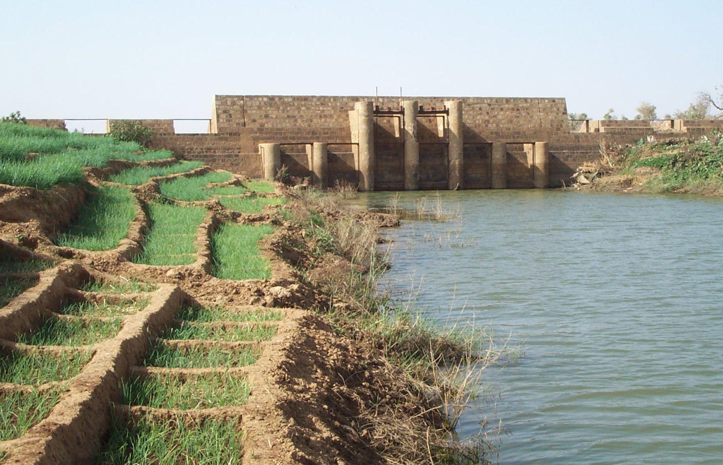
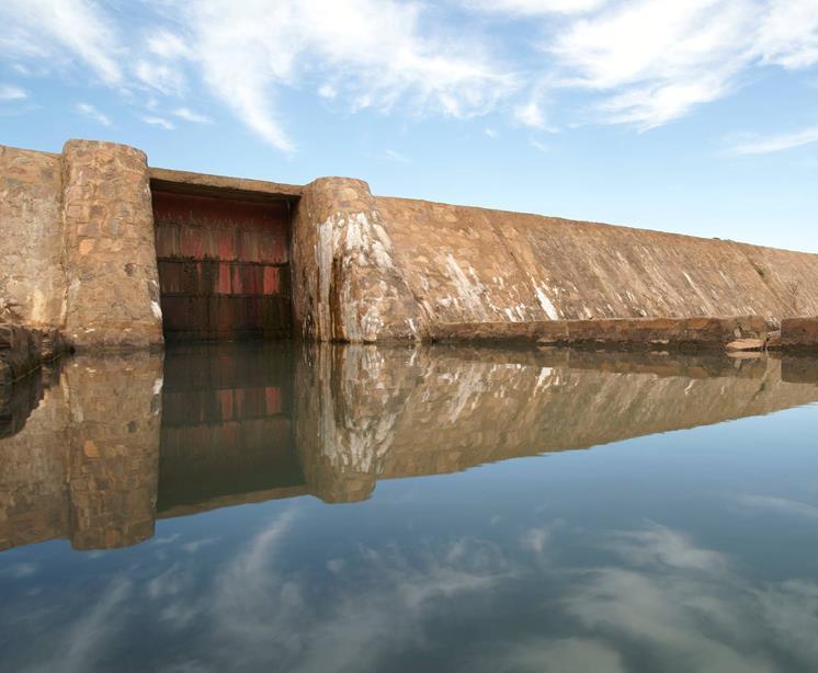
Small-scale dams are moderately-sized barriers built across valley bottoms to retain water from permanent watercourses or seasonal flows.
2.2 Detailed description of the Technology
Description:
They can range in length from 100 to 200 m, and the dam wall is usually between 2 and 4 m high. Small-scale dams impound permanent or seasonal water behind them, covering areas from 5 to 15 hectares. They are built with buttresses and a stilling basin. Depending on local conditions, the dam wall can be made of quarry stone joined with mortar or concrete. The dikes are made of earth and can be reinforced with stones. Some such structures are built as bridge dams, providing a means of crossing the valley. The effect on the water table depends on the depth at which the dam is anchored. The deeper the foundation, the more groundwater is retained. Sometimes, they are fitted with geomembranes which extend down deeper to retain more groundwater.
In the rainy season, water gradually accumulates behind the dike, increasing the availability of surface water during the rainy season and groundwater in the dry season. The land is farmed upstream and downstream both in the rainy season and the dry season. During the rainy season, rice is grown, and the areas around the body of water are used for other crops (flood-recession cropping). Dams increase the area of farmable land, yields and production. The water is also used for livestock, for fish farming and sometimes for household needs. The recharged water table feeds market garden wells, enabling farmers to grow vegetables in the dry season and permitting two or three crop harvests a year which increases the availability of food, providing income for farmers and guaranteeing work all year round. This improves the stability of local communities, increases their income and raises their standard of living.
Sustainable operation and management depend directly on the participatory approach. At the planning stage, the condition of the valley upstream and downstream and all user groups must be taken into account. The question of land tenure, in particular, must be settled before construction begins. It must be determined who the owner of the bottomlands is, who will be entitled to use them once the dam has been constructed, what uses will be permitted and under what conditions. The question of project ownership and upkeep must also be clarified. Today, the role of project owner is normally assigned to the commune authorities, although management of the dam is often delegated to a management committee. In order to avoid conflicts, it is essential to take into account all the user groups, livestock keepers in particular. Watering corridors must be established to prevent animals from damaging the crops. In order to maximise the value of the investment, well-organised management committees must be set up to ensure efficient crop production and oversee maintenance work. A management committee controls the opening and closing of the gates. It organises the maintenance of the structure and the implementation of any additional measures necessary to protect the gabion structures and stone bunds. It also collects and manages funds for the maintenance of the dam and organises meetings of farmers. In dry periods, it is important to manage water resources in such a way that downstream areas have enough water. When a series of dams are built on the same watercourse, an inter-dam committee may be required to manage the distribution of water and avoid conflicts between the users of the different dams.
Well-constructed small-scale dams last at least 50 years with a certain amount of upkeep. A high standard of technical planning and construction is required for small-scale dams to avoid subsequent damage. Depending on the natural characteristics of the watershed, small-scale dams may require additional SWC/SPR measures upstream to protect them from siltation.
These small-scale dams are suitable for use in narrower valleys, as a considerable volume of water can be impounded with a relatively short structure. They are not as well suited to wide, gently sloping valleys, as very long dikes are required and this increases the cost.
2.3 Photos of the Technology
Media Gallery
2.5 Country/ region/ locations where the Technology has been applied and which are covered by this assessment
Country:
Mali
Region/ State/ Province:
Mali
Specify the spread of the Technology:
- evenly spread over an area
If precise area is not known, indicate approximate area covered:
- 0.1-1 km2
Comments:
Small-scale dams impound permanent or seasonal water behind them, covering areas from 5 to 15 hectares
2.6 Date of implementation
If precise year is not known, indicate approximate date:
- 10-50 years ago
2.7 Introduction of the Technology
Specify how the Technology was introduced:
- through projects/ external interventions
Comments (type of project, etc.):
developed, implemented and disseminated as part of projects and programmes undertaken from the 1980s onwards to combat desertification and improve natural resource management. Implemented by GIZ (German Federal Enterprise for International Cooperation), and the project to rehabilitate dams and tracks (PRBP) and the Mali north programme (PMN)
3. Classification of the SLM Technology
3.1 Main purpose(s) of the Technology
- improve production
3.2 Current land use type(s) where the Technology is applied

Cropland
- Annual cropping
Number of growing seasons per year:
- 1
Specify:
Longest growing period in days: 120, Longest growing period from month to month: August to October

Waterways, waterbodies, wetlands
- Ponds, dams
Comments:
Major land use problems (compiler’s opinion): lack of irrigation water, surface water, soil erosion by water and wind
Constraints of common grazing land
Constraints of forested government-owned land or commons
3.4 Water supply
Water supply for the land on which the Technology is applied:
- mixed rainfed-irrigated
3.5 SLM group to which the Technology belongs
- irrigation management (incl. water supply, drainage)
- water diversion and drainage
- surface water management (spring, river, lakes, sea)
3.6 SLM measures comprising the Technology

structural measures
- S5: Dams, pans, ponds
3.7 Main types of land degradation addressed by the Technology

chemical soil deterioration
- Cn: fertility decline and reduced organic matter content (not caused by erosion)

biological degradation
- Bc: reduction of vegetation cover

water degradation
- Ha: aridification
- Hg: change in groundwater/aquifer level
Comments:
Main causes of degradation: crop management (annual, perennial, tree/shrub), floods, droughts, population pressure, land tenure
3.8 Prevention, reduction, or restoration of land degradation
Specify the goal of the Technology with regard to land degradation:
- prevent land degradation
- restore/ rehabilitate severely degraded land
4. Technical specifications, implementation activities, inputs, and costs
4.1 Technical drawing of the Technology
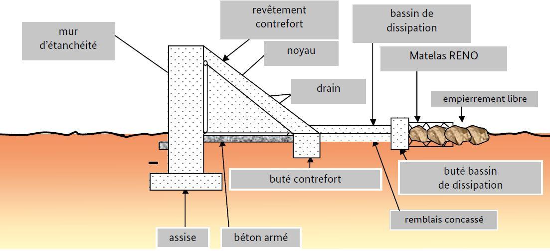
Technical specifications (related to technical drawing):
They can range in length from 100 to 200 m, and the dam wall is usually between 2 and 4 m high.
Technical knowledge required for field staff / advisors: high
Technical knowledge required for land users: low
Main technical functions: control of dispersed runoff: retain / trap, control of concentrated runoff: retain / trap, increase of infiltration, increase / maintain water stored in soil, increase of groundwater level / recharge of groundwater, water harvesting / increase water supply
Secondary technical functions: increase in organic matter, increase in nutrient availability (supply, recycling,…), sediment retention / trapping, sediment harvesting, increase of biomass (quantity), promotion of vegetation species and varieties (quality, eg palatable fodder)
Dam/ pan/ pond
Depth of ditches/pits/dams (m): 2-4
Length of ditches/pits/dams (m): 100-200
Author:
PIPRO-DB
4.3 Establishment activities
| Activity | Timing (season) | |
|---|---|---|
| 1. | At the planning stage, the condition of the valley upstream and downstream and all user groups must be taken into account. The question of land tenure must be settled before construction begins. The question of project ownership and upkeep must also be clarified. | |
| 2. | In order to avoid conflicts, it is essential to take into account all the user groups, livestock keepers in particular | |
| 3. | Construction of dam | |
| 4. | Watering corridors must be established to prevent animals from damaging the crops | |
| 5. | well-organised management committees must be set up to ensure efficient crop production and oversee maintenance work |
4.5 Maintenance/ recurrent activities
| Activity | Timing/ frequency | |
|---|---|---|
| 1. | A management committee controls the opening and closing of the gates. It organises the maintenance of the structure and the implementation of any additional measures necessary to protect the gabion structures and stone bunds. It also collects and manages funds for the maintenance of the dam and organises meetings of farmers | |
| 2. | Depending on the natural characteristics of the watershed, small-scale dams may require additional SWC/SPR measures upstream to protect them from siltation. |
4.7 Most important factors affecting the costs
Describe the most determinate factors affecting the costs:
The cost of small-scale dams varies greatly depending on the physical characteristics of the site, the size of the structure and the local availability of materials. In Dogon country, in Mali, the PDRT project constructed dams with cyclopean concrete costing an average of around 20 million CFA francs and between 3 and 5 million CFA francs per hectare. The internal rate of return of the dams built averaged 17% (Nill & Kobilke, 2002). Larger dams built in the Beledougou area cost 100-140 million CFA francs. Helvetas Swiss Intercooperation reports costs of around 20 million CFA francs for areas of 10-80 hectares (PASSIP, 2012).
5. Natural and human environment
5.1 Climate
Annual rainfall
- < 250 mm
- 251-500 mm
- 501-750 mm
- 751-1,000 mm
- 1,001-1,500 mm
- 1,501-2,000 mm
- 2,001-3,000 mm
- 3,001-4,000 mm
- > 4,000 mm
Agro-climatic zone
- semi-arid
Thermal climate class: subtropics
5.2 Topography
Slopes on average:
- flat (0-2%)
- gentle (3-5%)
- moderate (6-10%)
- rolling (11-15%)
- hilly (16-30%)
- steep (31-60%)
- very steep (>60%)
Landforms:
- plateau/plains
- ridges
- mountain slopes
- hill slopes
- footslopes
- valley floors
Altitudinal zone:
- 0-100 m a.s.l.
- 101-500 m a.s.l.
- 501-1,000 m a.s.l.
- 1,001-1,500 m a.s.l.
- 1,501-2,000 m a.s.l.
- 2,001-2,500 m a.s.l.
- 2,501-3,000 m a.s.l.
- 3,001-4,000 m a.s.l.
- > 4,000 m a.s.l.
5.3 Soils
Soil depth on average:
- very shallow (0-20 cm)
- shallow (21-50 cm)
- moderately deep (51-80 cm)
- deep (81-120 cm)
- very deep (> 120 cm)
Soil texture (topsoil):
- medium (loamy, silty)
- fine/ heavy (clay)
5.4 Water availability and quality
Ground water table:
5-50 m
Availability of surface water:
medium
5.5 Biodiversity
Species diversity:
- low
5.6 Characteristics of land users applying the Technology
Relative level of wealth:
- very poor
- poor
Level of mechanization:
- manual work
- animal traction
Gender:
- men
Indicate other relevant characteristics of the land users:
Population density: 10-50 persons/km2
Annual population growth: 3% - 4% (mostly poor households below poverty line).
Off-farm income specification: men migrate temporarily or permanently to cities for off-farm income
5.7 Average area of land used by land users applying the Technology
- < 0.5 ha
- 0.5-1 ha
- 1-2 ha
- 2-5 ha
- 5-15 ha
- 15-50 ha
- 50-100 ha
- 100-500 ha
- 500-1,000 ha
- 1,000-10,000 ha
- > 10,000 ha
Is this considered small-, medium- or large-scale (referring to local context)?
- small-scale
5.8 Land ownership, land use rights, and water use rights
Land ownership:
- state
Land use rights:
- communal (organized)
Water use rights:
- communal (organized)
Comments:
traditional land use rights on fields, communal land on pasture and forest land
5.9 Access to services and infrastructure
health:
- poor
- moderate
- good
education:
- poor
- moderate
- good
technical assistance:
- poor
- moderate
- good
employment (e.g. off-farm):
- poor
- moderate
- good
markets:
- poor
- moderate
- good
energy:
- poor
- moderate
- good
roads and transport:
- poor
- moderate
- good
drinking water and sanitation:
- poor
- moderate
- good
financial services:
- poor
- moderate
- good
6. Impacts and concluding statements
6.1 On-site impacts the Technology has shown
Socio-economic impacts
Production
crop production
fodder production
risk of production failure
production area
Water availability and quality
demand for irrigation water
Socio-cultural impacts
food security/ self-sufficiency
contribution to human well-being
Comments/ specify:
The water impounded by small-scale dams makes it possible to farm a much larger area in the valley bottoms and ensures better yields in the rainy season and also in the off-season. The production of food staples and market garden output increases significantly. More intense production ensures employment all year round, which improves the stability of local communities, increases their income and raises their standard of living.
Ecological impacts
Water cycle/ runoff
water quantity
harvesting/ collection of water
groundwater table/ aquifer
Soil
soil moisture
soil cover
soil loss
nutrient cycling/ recharge
Biodiversity: vegetation, animals
beneficial species
6.2 Off-site impacts the Technology has shown
reliable and stable stream flows in dry season
downstream flooding
downstream siltation
6.3 Exposure and sensitivity of the Technology to gradual climate change and climate-related extremes/ disasters (as perceived by land users)
Gradual climate change
Gradual climate change
| Season | increase or decrease | How does the Technology cope with it? | |
|---|---|---|---|
| annual temperature | increase | well |
Climate-related extremes (disasters)
Meteorological disasters
| How does the Technology cope with it? | |
|---|---|
| local rainstorm | well |
| local windstorm | well |
Climatological disasters
| How does the Technology cope with it? | |
|---|---|
| drought | well |
Hydrological disasters
| How does the Technology cope with it? | |
|---|---|
| general (river) flood | well |
Other climate-related consequences
Other climate-related consequences
| How does the Technology cope with it? | |
|---|---|
| reduced growing period | well |
6.4 Cost-benefit analysis
How do the benefits compare with the establishment costs (from land users’ perspective)?
Short-term returns:
positive
Long-term returns:
very positive
How do the benefits compare with the maintenance/ recurrent costs (from land users' perspective)?
Short-term returns:
very positive
Long-term returns:
very positive
6.7 Strengths/ advantages/ opportunities of the Technology
| Strengths/ advantages/ opportunities in the compiler’s or other key resource person’s view |
|---|
| The small-scale dams create water reserves. When there is not enough rain or during dry spells in the rainy season, the dams retain enough water for crops throughout their growth cycle. If rain-fed crops fail, production in the valley bottoms can mitigate these losses. In wet years, the dams regulate the flow of water, preventing heavy floodwaters from causing damage to land downstream. |
| The water impounded by small-scale dams makes it possible to farm a much larger area in the valley bottoms and ensures better yields in the rainy season and also in the off-season. The production of food staples and market garden output increases significantly. More intense production ensures employment all year round, which improves the stability of local communities, increases their income and raises their standard of living. |
| In the dry season, the recharged water table makes a second and even third crop harvest possible, increasing the availability of food, providing income for farmers and guaranteeing work all year round. |
| Replenished water tables not only improve crop output, they also reduce the time and effort that women devote to fetching water and make it easier to water livestock. |
6.8 Weaknesses/ disadvantages/ risks of the Technology and ways of overcoming them
| Weaknesses/ disadvantages/ risks in the compiler’s or other key resource person’s view | How can they be overcome? |
|---|---|
| A high standard of technical planning and construction is required for small-scale dams to avoid subsequent damage. | In order to maximise the value of the investment, well-organised management committees must be set up to ensure efficient crop production and oversee maintenance work. |
7. References and links
7.1 Methods/ sources of information
- field visits, field surveys
- interviews with land users
When were the data compiled (in the field)?
01/07/2012
7.2 References to available publications
Title, author, year, ISBN:
Good Practices in Soil and Water Conservation. A contribution to adaptation and farmers´ resilience towards climate change in the Sahel. Published by GIZ in 2012.
Available from where? Costs?
http://agriwaterpedia.info/wiki/Main_Page
Links and modules
Expand all Collapse allLinks
No links
Modules
No modules