Village irrigation schemes [Mali]
- Creation:
- Update:
- Compiler: Dieter Nill
- Editor: –
- Reviewers: Deborah Niggli, Alexandra Gavilano
Périmètres irrigués villageois (French)
technologies_1624 - Mali
View sections
Expand all Collapse all1. General information
1.2 Contact details of resource persons and institutions involved in the assessment and documentation of the Technology
SLM specialist:
Abdou Sani Mamadou
Programme d’Appui à l’agriculture Productive (PROMAP), Niamey, Niger
Niger
Name of project which facilitated the documentation/ evaluation of the Technology (if relevant)
Manual of Good Practices in Small Scale Irrigation in the Sahel (GIZ )Name of the institution(s) which facilitated the documentation/ evaluation of the Technology (if relevant)
Deutsche Gesellschaft für Internationale Zusammenarbeit (GIZ) - Germany1.3 Conditions regarding the use of data documented through WOCAT
The compiler and key resource person(s) accept the conditions regarding the use of data documented through WOCAT:
Yes
1.4 Declaration on sustainability of the described Technology
Is the Technology described here problematic with regard to land degradation, so that it cannot be declared a sustainable land management technology?
No
2. Description of the SLM Technology
2.1 Short description of the Technology
Definition of the Technology:
This technique makes it possible to develop unirrigated land at low cost to meet the demand for higher agricultural production and improved living conditions.
2.2 Detailed description of the Technology
Description:
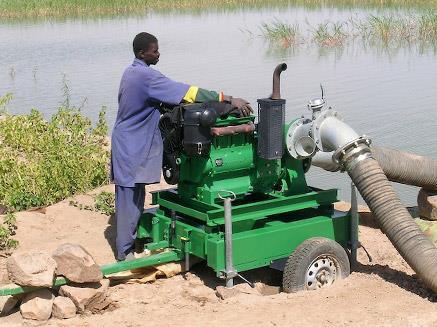
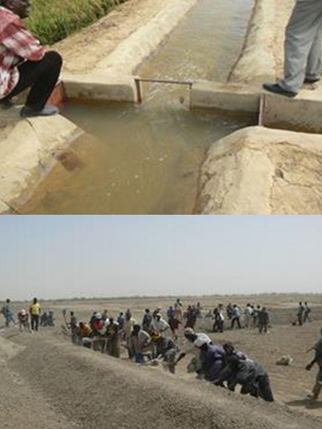
Village irrigation schemes provide irrigation for areas of between 20 and 40 hectares, surrounded by low earthen dikes. The system includes a stilling basin, which receives water from a mobile motor pump, a main channel, secondary channels and irrigation ditches. The scheme gives total control over the water available in the area, using a motor pump to move it around the system. The channels are open earth, and stretches where infiltration is high are lined with riprap. The structures are made of concrete. Village irrigation schemes require a source of water, and are therefore generally located along rivers or near permanent bodies of water.
Irrigation systems of this kind were constructed in Mali after the droughts in the 1970s under numerous development projects implemented to increase rice and wheat production. Between 1996 and 2010, for example, the IPRODI project established 450 irrigation schemes in northern Mali, creating an irrigated area of over 13,000 ha farmed by 55,000 farmers.
The water is pumped into the stilling basin and driven by the force of gravity into the main channel and the secondary and tertiary channels to the plots of individual users. Village irrigation schemes are an effective means of expanding the area of irrigated farmland and increasing production. As they permit the total control of the water available, farmers are practically unaffected by variations in rainfall, as long as the water source remains available. They therefore guarantee the production of food crops and straw for livestock. Village irrigation schemes create new irrigated farmland, which enable farmers to achieve high rice yields: around 6 tonnes per hectare. With an average price of 125 CFA francs a kilo for paddy rice, the value of output per hectare is around 750,000 CFA francs. Profit is estimated at around 300,000 CFA francs per hectare. At some sites, a second harvest is possible. Other plots are used for market gardening, with the production of onions, tomatoes, herbs, spices, etc. After the crops have been harvested, animals are allowed to graze on the plots.
The process to select an area to be developed begins with a request submitted by the community through the commune authorities. A feasibility study is conducted to determine potentially viable sites. The final choice is made in consultation with the regional and commune authorities and the villages concerned and in accordance with the financial resources available. The highly labour intensive approach is used, with beneficiaries participating in the construction work. The beneficiaries receive support from a project to plan and construct the irrigation system, purchase and install the pumping units (with financial contribution), purchase the tools and establish a start-up fund for the first season. Two technicians are trained per scheme. The village irrigation systems are operated and maintained by the beneficiaries and their management committee. The management committee must set up an operating and maintenance fund to purchase fuel and carry out any repairs. Farmers are required to pay a charge of seven sacks of paddy rice (around a third of their harvest) into the fund. In this way, the pumping units can be replaced after a number of years.
Those who participated in the construction work are given preference when the plots are distributed among the village’s families. A quarter-of-a-hectare plot is assigned to each ‘able-bodied person’ who participated in the work to construct the system. The total area assigned to each family therefore depends on the number of able-bodied people in the household. Once the system is in operation, technical services provide support to farmers for a time to teach them adapted farming practices.
2.3 Photos of the Technology
Media Gallery
2.5 Country/ region/ locations where the Technology has been applied and which are covered by this assessment
Country:
Mali
Region/ State/ Province:
Mali, Burkina Faso
Specify the spread of the Technology:
- evenly spread over an area
If precise area is not known, indicate approximate area covered:
- 100-1,000 km2
Comments:
Between 1996 and 2010, for example, the IPRODI project established 450 irrigation schemes in northern Mali, creating an irrigated area of over 13,000 ha farmed by 55,000 farmers. In Mali, there are numerous village irrigation schemes in the Inner Niger Delta and along the banks of the river Niger.
2.6 Date of implementation
If precise year is not known, indicate approximate date:
- 10-50 years ago
2.7 Introduction of the Technology
Specify how the Technology was introduced:
- through projects/ external interventions
Comments (type of project, etc.):
Developed, implemented and disseminated as part of projects and programmes undertaken from the 1980s onwards to combat desertification and improve natural resource management. Implemented by GIZ (German Federal Enterprise for International Cooperation), and the project to rehabilitate dams and tracks (PRBP) and the Mali north programme (PMN).
Irrigation systems of this kind were constructed in Mali after the droughts in the 1970s under numerous development projects implemented to increase rice and wheat production. Between 1996 and 2010, for example, the IPRODI project established 450 irrigation schemes in northern Mali, creating an irrigated area of over 13,000 ha farmed by 55,000 farmers.
3. Classification of the SLM Technology
3.1 Main purpose(s) of the Technology
- improve production
- create beneficial economic impact
3.2 Current land use type(s) where the Technology is applied

Cropland
- Annual cropping
Number of growing seasons per year:
- 1
Specify:
Longest growing period in days: 120, Longest growing period from month to month: August to October
Comments:
Major land use problems (compiler’s opinion): unequal distribution of irrigation water, fertility decline, Constraints of common grazing land, Constraints of forested government-owned land or commons
3.4 Water supply
Water supply for the land on which the Technology is applied:
- mixed rainfed-irrigated
3.5 SLM group to which the Technology belongs
- irrigation management (incl. water supply, drainage)
- surface water management (spring, river, lakes, sea)
3.6 SLM measures comprising the Technology

structural measures
- S3: Graded ditches, channels, waterways
- S11: Others
Comments:
Specification of other structural measures: irrigation scheme
3.7 Main types of land degradation addressed by the Technology

chemical soil deterioration
- Cn: fertility decline and reduced organic matter content (not caused by erosion)

biological degradation
- Bc: reduction of vegetation cover

water degradation
- Ha: aridification
- Hg: change in groundwater/aquifer level
Comments:
Main causes of degradation: crop management (annual, perennial, tree/shrub), floods, droughts, population pressure, land tenure
3.8 Prevention, reduction, or restoration of land degradation
Specify the goal of the Technology with regard to land degradation:
- restore/ rehabilitate severely degraded land
4. Technical specifications, implementation activities, inputs, and costs
4.1 Technical drawing of the Technology
Technical specifications (related to technical drawing):
Technical knowledge required for field staff / advisors: high
Technical knowledge required for land users: low
Main technical functions: control of dispersed runoff: retain / trap, control of concentrated runoff: retain / trap, control of concentrated runoff: drain / divert, increase of infiltration, increase / maintain water stored in soil, increase of groundwater level / recharge of groundwater, water harvesting / increase water supply, water spreading
Secondary technical functions: control of dispersed runoff: impede / retard, control of concentrated runoff: impede / retard, improvement of ground cover, increase in organic matter, increase of biomass (quantity)
4.3 Establishment activities
| Activity | Timing (season) | |
|---|---|---|
| 1. | request submitted by the community through the commune authorities | |
| 2. | A feasibility study is conducted to determine potentially viable sites | |
| 3. | final choice is made in consultation with the regional and commune authorities and the villages concerned and in accordance with the financial resources available | |
| 4. | beneficiaries participate in the construction work: construct the irrigation system, purchase and install the pumping units, purchase the tools and establish a start-up fund for the first season. |
4.4 Costs and inputs needed for establishment
| Specify input | Unit | Quantity | Costs per Unit | Total costs per input | % of costs borne by land users | |
|---|---|---|---|---|---|---|
| Other | total construction | 1.0 | 2893.14 | 2893.14 | 100.0 | |
| Total costs for establishment of the Technology | 2893.14 | |||||
| Total costs for establishment of the Technology in USD | 2893.14 | |||||
4.5 Maintenance/ recurrent activities
| Activity | Timing/ frequency | |
|---|---|---|
| 1. | pumping units can be replaced after a number of years |
4.7 Most important factors affecting the costs
Describe the most determinate factors affecting the costs:
The cost of implementing a village irrigation scheme is around 1.5 million CFA francs per hectare.
5. Natural and human environment
5.1 Climate
Annual rainfall
- < 250 mm
- 251-500 mm
- 501-750 mm
- 751-1,000 mm
- 1,001-1,500 mm
- 1,501-2,000 mm
- 2,001-3,000 mm
- 3,001-4,000 mm
- > 4,000 mm
Agro-climatic zone
- semi-arid
Thermal climate class: subtropics
5.2 Topography
Slopes on average:
- flat (0-2%)
- gentle (3-5%)
- moderate (6-10%)
- rolling (11-15%)
- hilly (16-30%)
- steep (31-60%)
- very steep (>60%)
Landforms:
- plateau/plains
- ridges
- mountain slopes
- hill slopes
- footslopes
- valley floors
Altitudinal zone:
- 0-100 m a.s.l.
- 101-500 m a.s.l.
- 501-1,000 m a.s.l.
- 1,001-1,500 m a.s.l.
- 1,501-2,000 m a.s.l.
- 2,001-2,500 m a.s.l.
- 2,501-3,000 m a.s.l.
- 3,001-4,000 m a.s.l.
- > 4,000 m a.s.l.
5.3 Soils
Soil depth on average:
- very shallow (0-20 cm)
- shallow (21-50 cm)
- moderately deep (51-80 cm)
- deep (81-120 cm)
- very deep (> 120 cm)
Soil texture (topsoil):
- medium (loamy, silty)
- fine/ heavy (clay)
5.4 Water availability and quality
Ground water table:
5-50 m
Availability of surface water:
medium
Comments and further specifications on water quality and quantity:
Groundwater table: > 10 m
Availability of surface water: surface runoff generated by limited but intense rainfalls
5.5 Biodiversity
Species diversity:
- low
5.6 Characteristics of land users applying the Technology
Relative level of wealth:
- very poor
- poor
Level of mechanization:
- manual work
- animal traction
Gender:
- men
Indicate other relevant characteristics of the land users:
Population density: 10-50 persons/km2
Annual population growth: 3% - 4% (mostly poor households below poverty line).
Off-farm income specification: men migrate temporarily or permanently to cities for off-farm income
5.7 Average area of land used by land users applying the Technology
- < 0.5 ha
- 0.5-1 ha
- 1-2 ha
- 2-5 ha
- 5-15 ha
- 15-50 ha
- 50-100 ha
- 100-500 ha
- 500-1,000 ha
- 1,000-10,000 ha
- > 10,000 ha
Is this considered small-, medium- or large-scale (referring to local context)?
- small-scale
5.8 Land ownership, land use rights, and water use rights
Land ownership:
- state
Land use rights:
- communal (organized)
Water use rights:
- communal (organized)
Comments:
traditional land use rights on fields, communal land on pasture and forest land
5.9 Access to services and infrastructure
health:
- poor
- moderate
- good
education:
- poor
- moderate
- good
technical assistance:
- poor
- moderate
- good
employment (e.g. off-farm):
- poor
- moderate
- good
markets:
- poor
- moderate
- good
energy:
- poor
- moderate
- good
roads and transport:
- poor
- moderate
- good
drinking water and sanitation:
- poor
- moderate
- good
financial services:
- poor
- moderate
- good
6. Impacts and concluding statements
6.1 On-site impacts the Technology has shown
Socio-economic impacts
Production
crop production
fodder production
animal production
risk of production failure
production area
Income and costs
farm income
Socio-cultural impacts
food security/ self-sufficiency
contribution to human well-being
Comments/ specify:
Village irrigation schemes are an effective means of expanding the area of irrigated farmland and increasing production. Farmers are practically unaffected by variations in rainfall, as long as the water source remains available. They therefore guarantee the production of food crops and straw for livestock.
Ecological impacts
Water cycle/ runoff
harvesting/ collection of water
groundwater table/ aquifer
Soil
soil moisture
soil cover
6.3 Exposure and sensitivity of the Technology to gradual climate change and climate-related extremes/ disasters (as perceived by land users)
Gradual climate change
Gradual climate change
| Season | increase or decrease | How does the Technology cope with it? | |
|---|---|---|---|
| annual temperature | increase | well |
Climate-related extremes (disasters)
Meteorological disasters
| How does the Technology cope with it? | |
|---|---|
| local rainstorm | well |
| local windstorm | well |
Climatological disasters
| How does the Technology cope with it? | |
|---|---|
| drought | well |
Hydrological disasters
| How does the Technology cope with it? | |
|---|---|
| general (river) flood | well |
Other climate-related consequences
Other climate-related consequences
| How does the Technology cope with it? | |
|---|---|
| reduced growing period | well |
6.4 Cost-benefit analysis
How do the benefits compare with the establishment costs (from land users’ perspective)?
Short-term returns:
positive
Long-term returns:
positive
How do the benefits compare with the maintenance/ recurrent costs (from land users' perspective)?
Short-term returns:
positive
Long-term returns:
positive
6.5 Adoption of the Technology
Comments:
There is a little trend towards spontaneous adoption of the Technology
Between 1996 and 2010, the IPRODI project established 450 irrigation schemes in northern Mali, creating an irrigated area of over 13,000 ha farmed by 55,000 farmers.
The earliest village irrigation schemes implemented under the IPRODI project in Mali are now 15 years old. They are still operating and in good condition. The low investment and maintenance costs and the assimilation of the operating techniques by the farmers ensure high sustainability.
6.7 Strengths/ advantages/ opportunities of the Technology
| Strengths/ advantages/ opportunities in the land user’s view |
|---|
| Those who participated in the construction work are given preference when the plots are distributed among the village’s families. |
| Strengths/ advantages/ opportunities in the compiler’s or other key resource person’s view |
|---|
| Village irrigation schemes are an effective means of expanding the area of irrigated farmland and increasing production. |
| Farmers are practically unaffected by variations in rainfall, as long as the water source remains available. They therefore guarantee the production of food crops and straw for livestock. |
| The earliest village irrigation schemes implemented under the IPRODI project in Mali are now 15 years old. They are still operating and in good condition. The low investment and maintenance costs and the assimilation of the operating techniques by the farmers ensure high sustainability. |
| The beneficiaries use their own funds to replace the pumping units when necessary and to extend the schemes. |
6.8 Weaknesses/ disadvantages/ risks of the Technology and ways of overcoming them
| Weaknesses/ disadvantages/ risks in the compiler’s or other key resource person’s view | How can they be overcome? |
|---|---|
| A high standard of technical planning (topographical surveying and soil studies) and construction is required to prevent cracks from appearing in the stilling basin or the main channel and avoid the problem of uneven water distribution within the irrigation area. The most serious risk for such schemes is failure of the pumping unit. | A local repair and maintenance service stocking a supply of spare parts must be available to provide assistance when the problem is beyond the abilities of the technicians trained for the scheme by the project. |
| The improved areas sometimes become a source of conflict after the irrigation system has been put in place. | The assessment carried out during the identification and planning stage must take into account any existing and potential conflicts. |
7. References and links
7.1 Methods/ sources of information
- field visits, field surveys
- interviews with land users
When were the data compiled (in the field)?
01/07/2012
7.2 References to available publications
Title, author, year, ISBN:
Good Practices in Soil and Water Conservation. A contribution to adaptation and farmers´ resilience towards climate change in the Sahel. Published by GIZ in 2012.
Available from where? Costs?
http://agriwaterpedia.info/wiki/Main_Page
Links and modules
Expand all Collapse allLinks
No links
Modules
No modules