Earth embankment dams [Mali]
- Creation:
- Update:
- Compiler: Nina Lauterburg
- Editor: –
- Reviewers: Deborah Niggli, Alexandra Gavilano
Barrages avec digues en terre (French)
technologies_1631 - Mali
View sections
Expand all Collapse all1. General information
1.2 Contact details of resource persons and institutions involved in the assessment and documentation of the Technology
SLM specialist:
Dembele Célestin
Helvetas Swiss Intercooperation
Mali
SLM specialist:
Doumbia Moussa
ADEPE MALI
Mali
Name of project which facilitated the documentation/ evaluation of the Technology (if relevant)
Manual of Good Practices in Small Scale Irrigation in the Sahel (GIZ )Name of the institution(s) which facilitated the documentation/ evaluation of the Technology (if relevant)
Deutsche Gesellschaft für Internationale Zusammenarbeit (GIZ) - Germany1.3 Conditions regarding the use of data documented through WOCAT
The compiler and key resource person(s) accept the conditions regarding the use of data documented through WOCAT:
Yes
1.4 Declaration on sustainability of the described Technology
Is the Technology described here problematic with regard to land degradation, so that it cannot be declared a sustainable land management technology?
No
2. Description of the SLM Technology
2.1 Short description of the Technology
Definition of the Technology:
Embankment dams are built to retain rainwater without totally blocking the flow of water, enabling the irrigation of a part of the plain.
2.2 Detailed description of the Technology
Description:
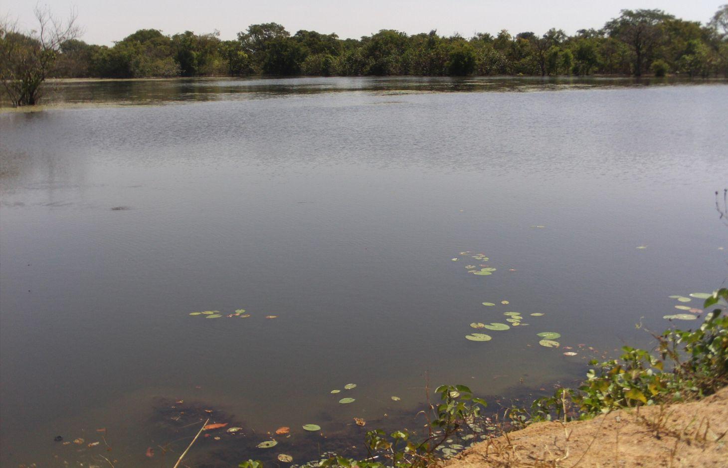
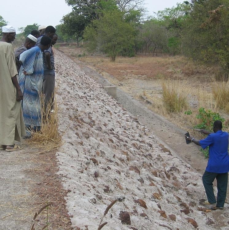
The installation of earth embankment dams in lowland areas comprises the following elements: 1) a compacted earth embankment, 100 to 450 metres in length; 2) a side spillway built with rubble or cyclopean concrete, 40 to 75 metres in length and connected to the embankment with lock walls; 3) a spillway stilling basin of loose stones; 4) dam height of up to five metres and a crest width of up to four metres; 5) a pond upstream of the embankment dug up to three to four metres deep for storing water throughout the dry season and, thereby, ensuring supplies for watering animals, market gardening and fish farming.
Embankment dams retain water in the basin for several months after the end of the rainy season, which can be used for watering livestock and crops off season; and they help raise the water table, which makes well water more easily accessible (at a depth of one to five metres). These dams are used for both controlled and free submersion.
The side of the embankment is about one metre higher than that of the side spillway. When the water level reaches the height of the side spillway, water flows down through the structure and continues along the riverbed on its normal route downstream. In-season rice growing is carried out both upstream and downstream of the dam. Upstream growers farming areas peripheral to the reservoir are advised to use varieties of floating rice or those that can withstand prolonged flooding. The seedlings for this kind of rice must be sown before the reservoir fills with water.
At the end of the growing season, the water is retained in the reservoir for watering animals and for fishing. Market gardening activities are carried out along the entire length of the river, with water being extracted from dug wells (sumps two to six metres deep).
In Mali, there are around 15 schemes in place in the circles of Sikasso, Kadiolo, Bougouni and Yanfolila, covering more than 1,000 hectares and benefiting 1,500 rural families. In these areas, more than 60% of rice growers are women. More than 100,000 head of cattle are watered each year from the reservoirs. The very large quantity of stored water considerably increases the potential to use land for vegetable and tree growing.
Local people formulate the requirement and negotiate with the commune on the investment programme; they identify the rules of access and set up the farming cooperatives and management bodies. The commune plans investments and assumes overall control of the construction work, delegates management to users, and validates the farming rules and oversees their correct application. Consultancies carry out the socio-economic, environmental and technical studies (scheme design, plans, models), draw up the invitation to tender document and support the tender selection process, and monitor and inspect works. Technical services oversee the application of technical and environmental standards and participate in ensuring sound financial practices (collection, financial control, public service concessions). Contractors carry out the construction work. The project team provides training (planning, social engineering, studies involving farmers, etc.), advisory support (organisation of users, formulation and validation of rules, area development plan, plan to develop and exploit value chains, selection of suitable crop varieties, management delegation procedures, procedures for securing land titles, etc.) and co-financing.
The users are divided up into management and maintenance teams and their respective responsibilities are clearly defined prior to the interim and final acceptance of works.
This type of scheme is effective in areas with good rainfall levels and in lowland areas where the water table is not very low. It is important to select lowland areas with the potential to store a substantial volume of water (topographic basins). This type of scheme works best in southern areas of Mali with 1,100 to 1,200 millimetres of precipitation per year.
2.3 Photos of the Technology
Media Gallery
2.5 Country/ region/ locations where the Technology has been applied and which are covered by this assessment
Country:
Mali
Region/ State/ Province:
Mali
Further specification of location:
Kadiolo, Sikasso, Bougouni, Yanfolila
Specify the spread of the Technology:
- evenly spread over an area
If the Technology is evenly spread over an area, specify area covered (in km2):
10.0
Comments:
Total area covered by the SLM Technology is 10 km2.
In the Sikasso region; in 15 or so communes within the circles of Kadiolo, Sikasso, Bougouni and Yanfolila. Around 1,000 hectares.
2.6 Date of implementation
If precise year is not known, indicate approximate date:
- 10-50 years ago
2.7 Introduction of the Technology
Specify how the Technology was introduced:
- through projects/ external interventions
Comments (type of project, etc.):
Since 2003, by HELVETAS Swiss Intercooperation
3. Classification of the SLM Technology
3.1 Main purpose(s) of the Technology
- improve production
- reduce, prevent, restore land degradation
3.2 Current land use type(s) where the Technology is applied
Land use mixed within the same land unit:
Yes
Specify mixed land use (crops/ grazing/ trees):
- Agro-pastoralism (incl. integrated crop-livestock)

Cropland
- Annual cropping
Number of growing seasons per year:
- 1
Specify:
Longest growing period in days: 120, Longest growing period from month to month: August-November

Grazing land

Waterways, waterbodies, wetlands
- Ponds, dams
Comments:
Major land use problems (compiler’s opinion): aridification, loss of water
Livestock density: 1-10 LU /km2
3.4 Water supply
Water supply for the land on which the Technology is applied:
- mixed rainfed-irrigated
3.5 SLM group to which the Technology belongs
- irrigation management (incl. water supply, drainage)
- water diversion and drainage
- surface water management (spring, river, lakes, sea)
3.6 SLM measures comprising the Technology

structural measures
- S5: Dams, pans, ponds
3.7 Main types of land degradation addressed by the Technology

biological degradation
- Bc: reduction of vegetation cover

water degradation
- Ha: aridification
- Hs: change in quantity of surface water
- Hg: change in groundwater/aquifer level
Comments:
Main causes of degradation: over abstraction / excessive withdrawal of water (for irrigation, industry, etc.), droughts
3.8 Prevention, reduction, or restoration of land degradation
Specify the goal of the Technology with regard to land degradation:
- reduce land degradation
4. Technical specifications, implementation activities, inputs, and costs
4.1 Technical drawing of the Technology
Technical specifications (related to technical drawing):
Technical knowledge required for field staff / advisors: high
Technical knowledge required for land users: low
Main technical functions: increase of groundwater level / recharge of groundwater, water harvesting / increase water supply
Secondary technical functions: increase of infiltration
Spillway
Length of ditches/pits/dams (m): 40-75
Dam/ pan/ pond
Depth of ditches/pits/dams (m): 3-4
Wall/ barrier
Depth of ditches/pits/dams (m): 5
Width of ditches/pits/dams (m): 4
Length of ditches/pits/dams (m): 100-450
Structural measure: spillway stilling basin of loose stones
4.2 General information regarding the calculation of inputs and costs
other/ national currency (specify):
CFA Franc
If relevant, indicate exchange rate from USD to local currency (e.g. 1 USD = 79.9 Brazilian Real): 1 USD =:
512.0
4.3 Establishment activities
| Activity | Timing (season) | |
|---|---|---|
| 1. | Local people formulate the requirement and negotiate with the commune on the investment programme; they identify the rules of access and set up the farming cooperatives and management bodies | |
| 2. | Contractors carry out the construction work |
4.5 Maintenance/ recurrent activities
| Activity | Timing/ frequency | |
|---|---|---|
| 1. | maintenance of the dam |
4.7 Most important factors affecting the costs
Describe the most determinate factors affecting the costs:
The cost of a scheme stands at around 40 million CFA francs (77838 Dollars) for between 10 to 80 hectares (0.5 to 4 million CFA francs per hectare (972-7780 Dollars)).
5. Natural and human environment
5.1 Climate
Annual rainfall
- < 250 mm
- 251-500 mm
- 501-750 mm
- 751-1,000 mm
- 1,001-1,500 mm
- 1,501-2,000 mm
- 2,001-3,000 mm
- 3,001-4,000 mm
- > 4,000 mm
Agro-climatic zone
- semi-arid
Thermal climate class: tropics
5.2 Topography
Slopes on average:
- flat (0-2%)
- gentle (3-5%)
- moderate (6-10%)
- rolling (11-15%)
- hilly (16-30%)
- steep (31-60%)
- very steep (>60%)
Landforms:
- plateau/plains
- ridges
- mountain slopes
- hill slopes
- footslopes
- valley floors
Altitudinal zone:
- 0-100 m a.s.l.
- 101-500 m a.s.l.
- 501-1,000 m a.s.l.
- 1,001-1,500 m a.s.l.
- 1,501-2,000 m a.s.l.
- 2,001-2,500 m a.s.l.
- 2,501-3,000 m a.s.l.
- 3,001-4,000 m a.s.l.
- > 4,000 m a.s.l.
5.3 Soils
Soil depth on average:
- very shallow (0-20 cm)
- shallow (21-50 cm)
- moderately deep (51-80 cm)
- deep (81-120 cm)
- very deep (> 120 cm)
Soil texture (topsoil):
- medium (loamy, silty)
- fine/ heavy (clay)
Topsoil organic matter:
- medium (1-3%)
- low (<1%)
5.4 Water availability and quality
Ground water table:
5-50 m
Availability of surface water:
medium
Water quality (untreated):
for agricultural use only (irrigation)
5.5 Biodiversity
Species diversity:
- medium
5.6 Characteristics of land users applying the Technology
Market orientation of production system:
- mixed (subsistence/ commercial)
Off-farm income:
- 10-50% of all income
Relative level of wealth:
- poor
- average
Level of mechanization:
- manual work
Gender:
- men
Indicate other relevant characteristics of the land users:
Population density: < 10 persons/km2
Annual population growth: 2% - 3%
10% of the land users are rich.
50% of the land users are average wealthy.
30% of the land users are poor.
10% of the land users are very poor.
5.7 Average area of land used by land users applying the Technology
- < 0.5 ha
- 0.5-1 ha
- 1-2 ha
- 2-5 ha
- 5-15 ha
- 15-50 ha
- 50-100 ha
- 100-500 ha
- 500-1,000 ha
- 1,000-10,000 ha
- > 10,000 ha
Is this considered small-, medium- or large-scale (referring to local context)?
- small-scale
5.8 Land ownership, land use rights, and water use rights
Comments:
The irrigated land is allocated by the chief
5.9 Access to services and infrastructure
health:
- poor
- moderate
- good
education:
- poor
- moderate
- good
technical assistance:
- poor
- moderate
- good
employment (e.g. off-farm):
- poor
- moderate
- good
markets:
- poor
- moderate
- good
energy:
- poor
- moderate
- good
roads and transport:
- poor
- moderate
- good
drinking water and sanitation:
- poor
- moderate
- good
financial services:
- poor
- moderate
- good
6. Impacts and concluding statements
6.1 On-site impacts the Technology has shown
Socio-economic impacts
Production
crop production
animal production
risk of production failure
production area
Income and costs
farm income
Socio-cultural impacts
food security/ self-sufficiency
conflict mitigation
contribution to human well-being
Comments/ specify:
In Mali, there are around 15 schemes in place in the circles of Sikasso, Kadiolo, Bougouni and Yanfolila, covering more than 1,000 hectares and benefiting 1,500 rural families. In these areas, more than 60% of rice growers are women. More than 100,000 head of cattle are watered each year from the reservoirs. The very large quantity of stored water considerably increases the potential to use land for vegetable and tree growing.
Ecological impacts
Water cycle/ runoff
harvesting/ collection of water
groundwater table/ aquifer
6.2 Off-site impacts the Technology has shown
reliable and stable stream flows in dry season
downstream flooding
wind transported sediments
6.3 Exposure and sensitivity of the Technology to gradual climate change and climate-related extremes/ disasters (as perceived by land users)
Gradual climate change
Gradual climate change
| Season | increase or decrease | How does the Technology cope with it? | |
|---|---|---|---|
| annual temperature | increase | well |
Climate-related extremes (disasters)
Meteorological disasters
| How does the Technology cope with it? | |
|---|---|
| local rainstorm | well |
| local windstorm | well |
Climatological disasters
| How does the Technology cope with it? | |
|---|---|
| drought | well |
Hydrological disasters
| How does the Technology cope with it? | |
|---|---|
| general (river) flood | well |
Other climate-related consequences
Other climate-related consequences
| How does the Technology cope with it? | |
|---|---|
| reduced growing period | well |
6.4 Cost-benefit analysis
How do the benefits compare with the establishment costs (from land users’ perspective)?
Short-term returns:
positive
Long-term returns:
very positive
How do the benefits compare with the maintenance/ recurrent costs (from land users' perspective)?
Short-term returns:
very positive
Long-term returns:
very positive
6.5 Adoption of the Technology
Comments:
There is a moderate trend towards spontaneous adoption of the Technology
In Mali, there are around 15 schemes in place in the circles of Sikasso, Kadiolo, Bougouni and Yanfolila, covering more than 1,000 hectares and benefiting 1,500 rural families. The technique has now been mastered by a number of local companies. No dam has failed in the last eight years.
The technology has also been successfully adopted in northern Côte d’Ivoire.
6.7 Strengths/ advantages/ opportunities of the Technology
| Strengths/ advantages/ opportunities in the land user’s view |
|---|
| At the community level, larger revenues are being generated. |
| The works are not overly complex from a technical point of view and can be delivered at a reasonable cost. |
| Strengths/ advantages/ opportunities in the compiler’s or other key resource person’s view |
|---|
| The scheme has enabled irrigable areas to be rehabilitated and extended. agricultural intensification is possible year round, providing several harvests. Farming yields have doubled, or even tripled, due to the availability of water supplies and the technical support that continued up until the end of works. High-added-value vegetable crops have been produced. |
| The water table has risen and rises to the surface at times. The wells located in the lowland basin no longer dry up. |
| Watering livestock is not difficult and the pastures in the catchment basin are larger because of the dam. Grazing animals stay in the area longer and produce manure. Moreover, fees are collected for the watering of livestock. |
| Fish have returned, along with crocodiles; both having previously disappeared from these village areas. There has been a five-fold increase in the volume of fishing activities, catches and trade. |
| Greater levels of biodiversity and vegetation have been observed in the vicinity of schemes. |
6.8 Weaknesses/ disadvantages/ risks of the Technology and ways of overcoming them
| Weaknesses/ disadvantages/ risks in the compiler’s or other key resource person’s view | How can they be overcome? |
|---|---|
| Installation requires the use of bulldozers and compactors, equipment that is not always available from local companies. | It is essential for regulatory and arbitration mechanisms to provide support in these areas throughout the process. |
| The initial request for a scheme is sometimes drawn up by a specific group of users who may not take into account the full range of functions offered by the scheme: indigenous livestock rearing, transhumant livestock rearing, rice growing, tree growing, market gardening, fishing, brickmaking, etc. |
7. References and links
7.1 Methods/ sources of information
- field visits, field surveys
- interviews with land users
When were the data compiled (in the field)?
01/07/2012
7.2 References to available publications
Title, author, year, ISBN:
Manual of Good Practices in Small Scale Irrigation in the Sahel. Experiences from Mali. Published by GIZ in 2014.
Available from where? Costs?
http://star-www.giz.de/starweb/giz/pub/servlet.starweb
Title, author, year, ISBN:
Intercooperation, Sahel Delegation (2008): Les aménagements de bas-fonds dans le bassin cotonnier de Sikasso. Expérience du programme Jékasy. [Developing lowland areas in the Sikasso cotton-growing basin. The Jékasy programme’s experience.] Intercooperation, Sahel Delegation: Capitalisation des experiences du programme Jékasy en gestion des ressources naturelles et aménagements des bas-fonds. [Capitalising on the experiences of the Jékasy programme in managing natural resources and lowland schemes.] Rapport Collecte de données sur la valorisation des ouvrages réalisés dans le Pôle de Bougouni sur le financement APEL [Data collection report on developing the value of APEL-funded schemes carried out in the Bougouni Hub] – Bougouni, April 2013
Links and modules
Expand all Collapse allLinks
No links
Modules
No modules