Riverbank Protection [Nepal]
- Creation:
- Update:
- Compiler: Shreedip Sigdel
- Editor: –
- Reviewers: David Streiff, Alexandra Gavilano
Nadi Kinara Samrakchen (Main Contributor: Uddhaw Ghimire, DSCO)
technologies_1692 - Nepal
View sections
Expand all Collapse all1. General information
1.2 Contact details of resource persons and institutions involved in the assessment and documentation of the Technology
SLM specialist:
Ghimire Uddhaw
District Soil Conservation Office
Nepal
Office:
Programme Coordination Office
Helvetas Swiss Intercooperation Nepal
Nepal
Name of the institution(s) which facilitated the documentation/ evaluation of the Technology (if relevant)
District Soil Conservation Office (DSCO) - NepalName of the institution(s) which facilitated the documentation/ evaluation of the Technology (if relevant)
HELVETAS (Swiss Intercooperation)Name of the institution(s) which facilitated the documentation/ evaluation of the Technology (if relevant)
Department of Soil Conservation and Watershed Mana (Department of Soil Conservation and Watershed Mana) - NepalName of the institution(s) which facilitated the documentation/ evaluation of the Technology (if relevant)
ICIMOD International Centre for Integrated Mountain Development (ICIMOD) - Nepal1.3 Conditions regarding the use of data documented through WOCAT
The compiler and key resource person(s) accept the conditions regarding the use of data documented through WOCAT:
Yes
2. Description of the SLM Technology
2.1 Short description of the Technology
Definition of the Technology:
Local materials and knowledge can be used to construct low-cost structural measures that help to prevent the erosion of riverbanks and the loss of agricultural and residential land.
2.2 Detailed description of the Technology
Description:
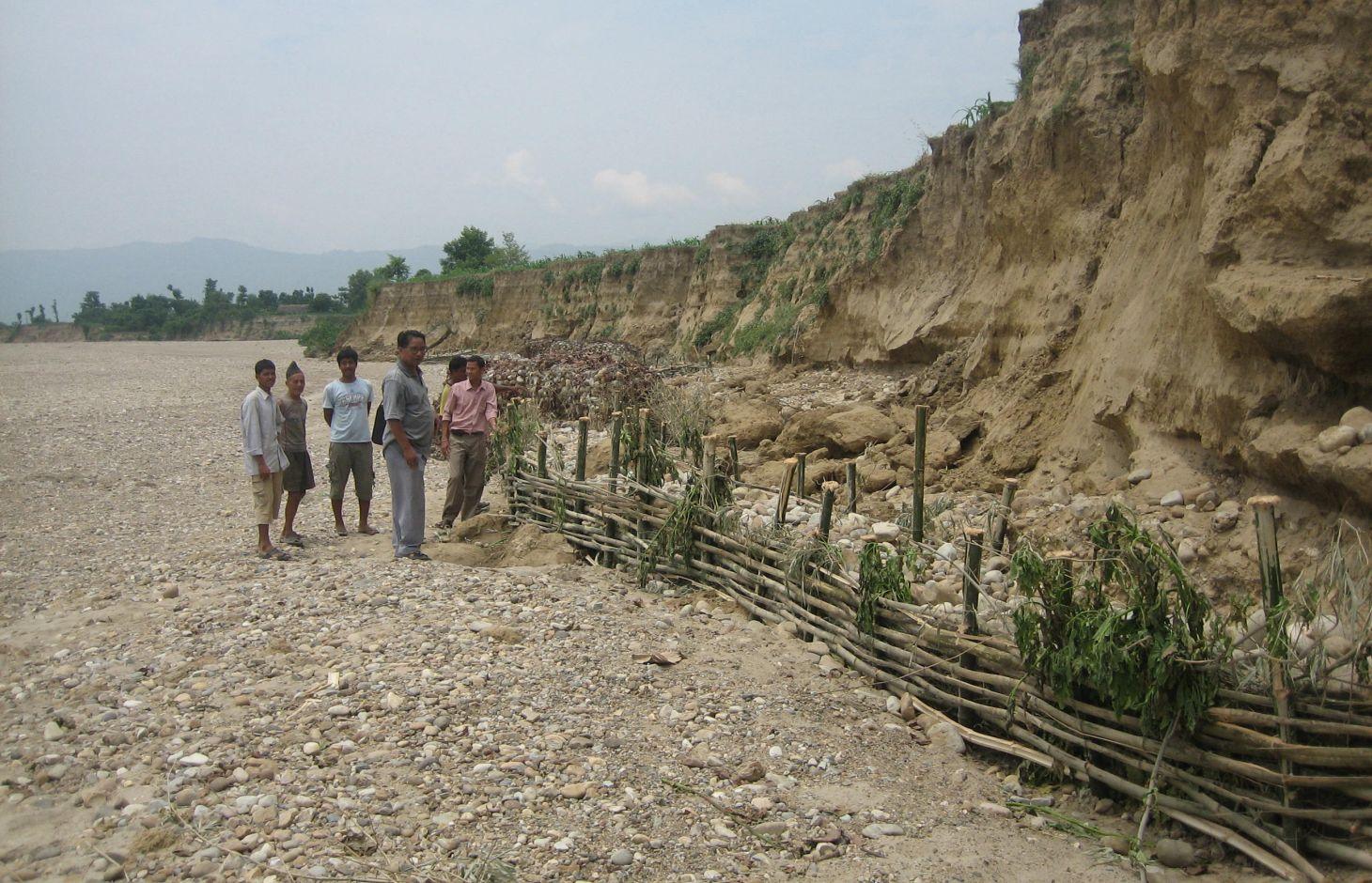
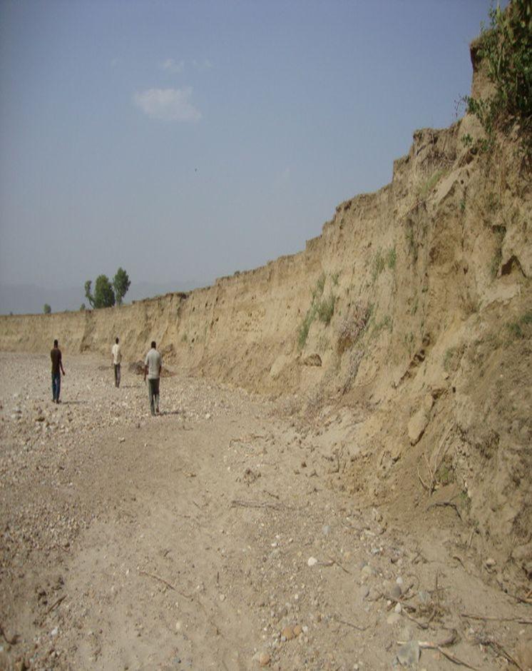
Riverbank cutting occurs naturally along the rivers that run along the foothills of the Chure (Siwalik) range in Nepal when the stream collides with the river bank or the bank is eroded by water coming from agricultural land above the affected area. When riverbank cutting occurs, it leaves behind an eroded area shaped like a small cliff. This erosion takes place naturally and is difficult to stop because the site is devoid of natural vegetation. It is important to undertake conservation measures because when the riverbank is eroded it damages agricultural land and decreases soil fertility. When the productivity of the land is decreased it affects the lives and livelihoods of nearby communities most of whom are subsistence farmers.
Purpose of the Technology: Communities have developed local measures to help protect the riverbanks and to prevent further erosion and cutting. This technology uses both structural and vegetative measures to help control the erosion and protect both agricultural land and settlement areas from flooding. Check dams are placed at intervals to divert water, additional support is provided by spurs. Bamboo rhizomes are planted between them and Napier grass (Pennisetum purpureum) is planted at the back of the structures so that as the plants grow their roots help to anchor the structure. The washed out areas can be used to generate some income by planting them with greenery and fruit trees. The site needs to be monitored annually and where necessary the structures either need to be repaired or supplemented by building additional structures.
Establishment / maintenance activities and inputs: This technology is a blend of local skills and expertise with some external technical input. The key features of the technology are as follow:
• It uses locally available construction materials, tools, equipment, and vegetation.
• It is easy to replicate.
• It is affordable for local people.
• It is environmentally friendly.
A demonstration plot was established by the District Soil Conservation Office (DSCO) in Dang, but the technology needs to be replicated in other areas with action research and experience
2.3 Photos of the Technology
Media Gallery
2.5 Country/ region/ locations where the Technology has been applied and which are covered by this assessment
Country:
Nepal
Further specification of location:
Gobardiha-9, Madhabpur, Dang District,
Specify the spread of the Technology:
- applied at specific points/ concentrated on a small area
2.7 Introduction of the Technology
Specify how the Technology was introduced:
- through projects/ external interventions
3. Classification of the SLM Technology
3.1 Main purpose(s) of the Technology
- reduce, prevent, restore land degradation
- protect a watershed/ downstream areas – in combination with other Technologies
- reduce risk of disasters
3.2 Current land use type(s) where the Technology is applied

Cropland
- Annual cropping
Number of growing seasons per year:
- 2

Forest/ woodlands
Products and services:
- Fuelwood
- Grazing/ browsing
Comments:
Major land use problems (compiler’s opinion): The land is degraded by riverbed cutting and nearby villages are threatened by flooding. The amount of land available for agriculture decreases annually giving rise to a food security problem. Entire villages may have to move to avoid being flooded.
Forest products and services: fuelwood, grazing / browsing
Livestock is grazing on crop residues
3.5 SLM group to which the Technology belongs
- surface water management (spring, river, lakes, sea)
3.6 SLM measures comprising the Technology

vegetative measures
- V2: Grasses and perennial herbaceous plants

structural measures
- S5: Dams, pans, ponds
3.7 Main types of land degradation addressed by the Technology

soil erosion by water
- Wr: riverbank erosion
Comments:
Main causes of degradation: floods
3.8 Prevention, reduction, or restoration of land degradation
Specify the goal of the Technology with regard to land degradation:
- prevent land degradation
- reduce land degradation
4. Technical specifications, implementation activities, inputs, and costs
4.1 Technical drawing of the Technology
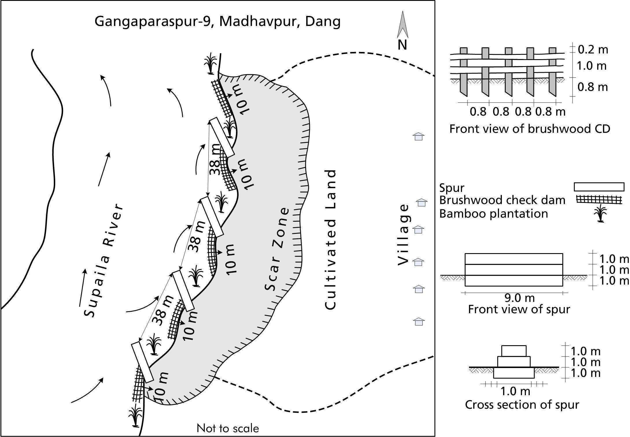
Technical specifications (related to technical drawing):
A low cost riverbank protection scheme that can be implemented using mostly local materials.
Technical knowledge required for field staff / advisors: low
Technical knowledge required for land users: moderate
Main technical functions: control of dispersed runoff: impede / retard, control of concentrated runoff: impede / retard
Secondary technical functions: improvement of ground cover, stabilisation of soil (eg by tree roots against land slides)
Author:
Bhojdeo Mandal, AK Thaku
4.2 General information regarding the calculation of inputs and costs
Specify how costs and inputs were calculated:
- per Technology area
Indicate size and area unit:
ha
Specify currency used for cost calculations:
- USD
4.3 Establishment activities
| Activity | Timing (season) | |
|---|---|---|
| 1. | Structural: Check dam construction | |
| 2. | Spur construction | |
| 3. | Vegetative: Pitting | |
| 4. | Bamboo planting | |
| 5. | Napier grass planting |
4.4 Costs and inputs needed for establishment
| Specify input | Unit | Quantity | Costs per Unit | Total costs per input | % of costs borne by land users | |
|---|---|---|---|---|---|---|
| Labour | Construction of rivervbank protection | ha | 1.0 | 892.0 | 892.0 | 51.0 |
| Equipment | Tools | ha | 1.0 | 21.0 | 21.0 | 51.0 |
| Plant material | Napier grass, bamboo seedlings | ha | 1.0 | 14.0 | 14.0 | |
| Construction material | Stone | ha | 1.0 | 1281.0 | 1281.0 | 51.0 |
| Construction material | Bamboo poles | ha | 1.0 | 274.0 | 274.0 | 51.0 |
| Construction material | Wire for gabion box | ha | 1.0 | 1644.0 | 1644.0 | 51.0 |
| Total costs for establishment of the Technology | 4126.0 | |||||
| Total costs for establishment of the Technology in USD | 4126.0 | |||||
If land user bore less than 100% of costs, indicate who covered the remaining costs:
The gabion boxes, the transportation costs, and some skilled labour by DSCO, Dang; whereas, the costs for the tools, local materials, and all of the unskilled labour were borne by the local community
4.5 Maintenance/ recurrent activities
| Activity | Timing/ frequency | |
|---|---|---|
| 1. | Structural: Verify the integrity of the spurs and check dams; fortify or repair as needed. | |
| 2. | Vegetative: Maintenance costs cover only replacement and maintenance to be done by the local community for a few years until the vegetative structures are well established at the site. | |
| 3. | VegetativeCheck to see that the Napier grass seedlings have taken root; add additional plants as needed. |
4.6 Costs and inputs needed for maintenance/ recurrent activities (per year)
| Specify input | Unit | Quantity | Costs per Unit | Total costs per input | % of costs borne by land users | |
|---|---|---|---|---|---|---|
| Labour | Fortify and reapir check dams | ha | 1.0 | 52.0 | 52.0 | 100.0 |
| Plant material | Napier grass, bamboo seedlings | ha | 1.0 | 7.0 | 7.0 | 100.0 |
| Construction material | Bamboo poles for replacing | ha | 1.0 | 123.0 | 123.0 | 100.0 |
| Total costs for maintenance of the Technology | 182.0 | |||||
| Total costs for maintenance of the Technology in USD | 182.0 | |||||
4.7 Most important factors affecting the costs
Describe the most determinate factors affecting the costs:
The costs for the gabion boxes, the transportation costs, and some skilled labour, were borne by the DSCO, Dang; whereas, the costs for the tools, local materials, and all of the unskilled labour were borne by the local community.
All costs and amounts are rough estimates by the technicians and authors.
5. Natural and human environment
5.1 Climate
Annual rainfall
- < 250 mm
- 251-500 mm
- 501-750 mm
- 751-1,000 mm
- 1,001-1,500 mm
- 1,501-2,000 mm
- 2,001-3,000 mm
- 3,001-4,000 mm
- > 4,000 mm
Agro-climatic zone
- sub-humid
Thermal climate class: tropics
5.2 Topography
Slopes on average:
- flat (0-2%)
- gentle (3-5%)
- moderate (6-10%)
- rolling (11-15%)
- hilly (16-30%)
- steep (31-60%)
- very steep (>60%)
Landforms:
- plateau/plains
- ridges
- mountain slopes
- hill slopes
- footslopes
- valley floors
Altitudinal zone:
- 0-100 m a.s.l.
- 101-500 m a.s.l.
- 501-1,000 m a.s.l.
- 1,001-1,500 m a.s.l.
- 1,501-2,000 m a.s.l.
- 2,001-2,500 m a.s.l.
- 2,501-3,000 m a.s.l.
- 3,001-4,000 m a.s.l.
- > 4,000 m a.s.l.
5.3 Soils
Soil depth on average:
- very shallow (0-20 cm)
- shallow (21-50 cm)
- moderately deep (51-80 cm)
- deep (81-120 cm)
- very deep (> 120 cm)
Soil texture (topsoil):
- coarse/ light (sandy)
Topsoil organic matter:
- low (<1%)
If available, attach full soil description or specify the available information, e.g. soil type, soil PH/ acidity, Cation Exchange Capacity, nitrogen, salinity etc.
Soil fertility is very low
Soil drainage / infiltration is good
Soil water storage capacity is very low
5.4 Water availability and quality
Ground water table:
5-50 m
Availability of surface water:
poor/ none
Water quality (untreated):
for agricultural use only (irrigation)
5.5 Biodiversity
Species diversity:
- low
5.6 Characteristics of land users applying the Technology
Market orientation of production system:
- subsistence (self-supply)
Off-farm income:
- > 50% of all income
Relative level of wealth:
- poor
Individuals or groups:
- groups/ community
Level of mechanization:
- manual work
- animal traction
Indicate other relevant characteristics of the land users:
Population density: 100-200 persons/km2
Annual population growth: 2% - 3%
5.7 Average area of land used by land users applying the Technology
- < 0.5 ha
- 0.5-1 ha
- 1-2 ha
- 2-5 ha
- 5-15 ha
- 15-50 ha
- 50-100 ha
- 100-500 ha
- 500-1,000 ha
- 1,000-10,000 ha
- > 10,000 ha
5.8 Land ownership, land use rights, and water use rights
Land ownership:
- individual, titled
Land use rights:
- individual
Water use rights:
- communal (organized)
6. Impacts and concluding statements
6.1 On-site impacts the Technology has shown
Socio-economic impacts
Production
risk of production failure
Income and costs
farm income
diversity of income sources
workload
Socio-cultural impacts
food security/ self-sufficiency
community institutions
situation of socially and economically disadvantaged groups
livelihood and human well-being
Comments/ specify:
Agricultural land is conserved and production is increased
Ecological impacts
Soil
soil loss
Climate and disaster risk reduction
flood impacts
drought impacts
impacts of cyclones, rain storms
6.2 Off-site impacts the Technology has shown
downstream flooding
risk of flodd for public and private infrastructure, even at some distance from the site
6.3 Exposure and sensitivity of the Technology to gradual climate change and climate-related extremes/ disasters (as perceived by land users)
Gradual climate change
Gradual climate change
| Season | increase or decrease | How does the Technology cope with it? | |
|---|---|---|---|
| annual temperature | increase | well |
Climate-related extremes (disasters)
Hydrological disasters
| How does the Technology cope with it? | |
|---|---|
| general (river) flood | not well |
Comments:
Previously, the problem was tackled using traditional techniques alone but the results were not wholly satisfactory. After modifying (as discussed below) the structures are more robust and can withstand greater floods.
6.4 Cost-benefit analysis
How do the benefits compare with the establishment costs (from land users’ perspective)?
Short-term returns:
very positive
Long-term returns:
very positive
How do the benefits compare with the maintenance/ recurrent costs (from land users' perspective)?
Short-term returns:
positive
Long-term returns:
positive
6.5 Adoption of the Technology
- > 50%
If available, quantify (no. of households and/ or area covered):
47 households in an area of 10 ha
Of all those who have adopted the Technology, how many did so spontaneously, i.e. without receiving any material incentives/ payments?
- 0-10%
Comments:
There is a little trend towards spontaneous adoption of the Technology
Comments on adoption trend: A community of 47 households has agreed to use this technology to help prevent soil erosion caused by flooding. The community had started to implement local measures to minimize riverbank cutting but the efforts were not successful. The systematic introduction of well-planned gabion spurs and bamboo check dams constructed using only locally available materials, has been successful. The community is convinced that this technology is beneficial and they will continue to propagate it themselves as needed.
6.7 Strengths/ advantages/ opportunities of the Technology
| Strengths/ advantages/ opportunities in the compiler’s or other key resource person’s view |
|---|
|
The technology is low cost and can be implemented by the local community with the assistance of some technical support from the DSCO, Dang. How can they be sustained / enhanced? The DSCO, Dang, needs to continue to support the community in its efforts by technical backstopping, regular follow-up, and continued scaling up of the technology. |
|
The technology predominantly uses locally available materials. How can they be sustained / enhanced? Replication of this technology should be encouraged by the community as well as by the DSCO, Dang |
|
In the long run, vegetative structures help to propagate greenery and in so doing, they promote climate change adaptation and mitigation. How can they be sustained / enhanced? Communities should be made aware of the hazards of climate change and of what mitigation measures can be employed. |
|
Traditional measures used to help protect against flooding were very labour intensive and difficult to implement. This new method is low cost, easy to adopt, and sustainable. How can they be sustained / enhanced? Additional training with local communities can help to spread the expertise |
6.8 Weaknesses/ disadvantages/ risks of the Technology and ways of overcoming them
| Weaknesses/ disadvantages/ risks in the compiler’s or other key resource person’s view | How can they be overcome? |
|---|---|
| Vegetative structures may not always take root as intended; the initial cost for the gabion cages can be high. | Try to implement the technology using vegetative measures |
| Despite the fact that the technology is known to be effective, it is not being widely implemented. | Communities need greater awareness; intensive extension is needed in order for the technology to have widespread acceptance. |
7. References and links
7.1 Methods/ sources of information
7.2 References to available publications
Title, author, year, ISBN:
District Forest Office, Dang; Soil Conservation and Watershed Management Measures and Low Cost Techniques; Environment Statistics of Nepal, Annual Report (2065/66)
Available from where? Costs?
Available at DSCO, Dang and DCSWM, Kathmandu
Links and modules
Expand all Collapse allLinks
No links
Modules
No modules