Riverbank Protection [เนปาล]
- ผู้สร้างสรรค์:
- การอัพเดท:
- ผู้รวบรวม: Shreedip Sigdel
- ผู้เรียบเรียง: –
- ผู้ตรวจสอบ: David Streiff, Alexandra Gavilano
Nadi Kinara Samrakchen (Main Contributor: Uddhaw Ghimire, DSCO)
technologies_1692 - เนปาล
ดูส่วนย่อย
ขยายทั้งหมด ย่อทั้งหมด1. ข้อมูลทั่วไป
1.2 รายละเอียดที่ติดต่อได้ของผู้รวบรวมและองค์กรที่เกี่ยวข้องในการประเมินและการจัดเตรียมทำเอกสารของเทคโนโลยี
ผู้เชี่ยวชาญ SLM:
Ghimire Uddhaw
District Soil Conservation Office
เนปาล
Office:
Programme Coordination Office
Helvetas Swiss Intercooperation Nepal
เนปาล
ชื่อขององค์กรซึ่งอำนวยความสะดวกในการทำเอกสารหรือการประเมินเทคโนโลยี (ถ้าเกี่ยวข้อง)
District Soil Conservation Office (DSCO) - เนปาลชื่อขององค์กรซึ่งอำนวยความสะดวกในการทำเอกสารหรือการประเมินเทคโนโลยี (ถ้าเกี่ยวข้อง)
HELVETAS (Swiss Intercooperation)ชื่อขององค์กรซึ่งอำนวยความสะดวกในการทำเอกสารหรือการประเมินเทคโนโลยี (ถ้าเกี่ยวข้อง)
Department of Soil Conservation and Watershed Mana (Department of Soil Conservation and Watershed Mana) - เนปาลชื่อขององค์กรซึ่งอำนวยความสะดวกในการทำเอกสารหรือการประเมินเทคโนโลยี (ถ้าเกี่ยวข้อง)
ICIMOD International Centre for Integrated Mountain Development (ICIMOD) - เนปาล1.3 เงื่อนไขการใช้ข้อมูลที่ได้บันทึกผ่านทาง WOCAT
ผู้รวบรวมและวิทยากรหลักยอมรับเงื่อนไขเกี่ยวกับการใช้ข้อมูลที่ถูกบันทึกผ่านทาง WOCAT:
ใช่
2. การอธิบายลักษณะของเทคโนโลยี SLM
2.1 การอธิบายแบบสั้น ๆ ของเทคโนโลยี
คำจำกัดความของเทคโนโลยี:
Local materials and knowledge can be used to construct low-cost structural measures that help to prevent the erosion of riverbanks and the loss of agricultural and residential land.
2.2 การอธิบายแบบละเอียดของเทคโนโลยี
คำอธิบาย:
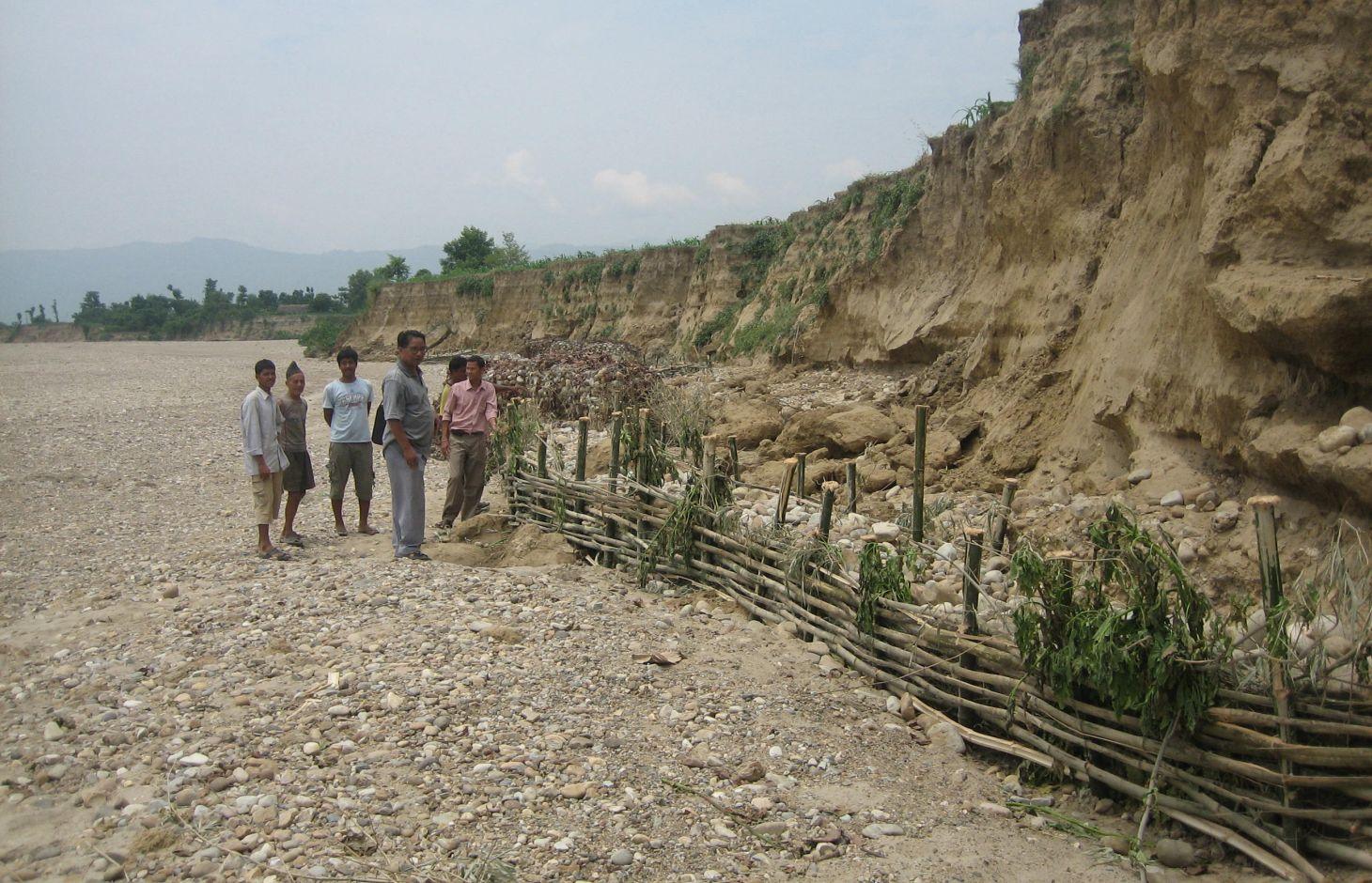
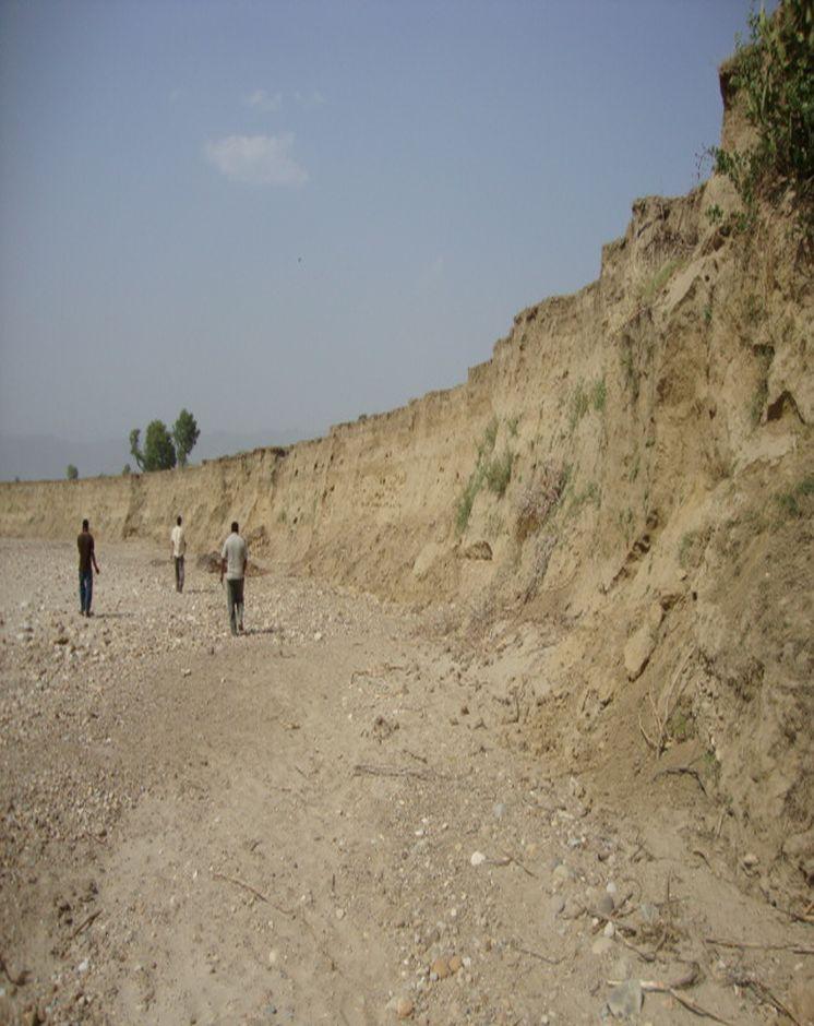
Riverbank cutting occurs naturally along the rivers that run along the foothills of the Chure (Siwalik) range in Nepal when the stream collides with the river bank or the bank is eroded by water coming from agricultural land above the affected area. When riverbank cutting occurs, it leaves behind an eroded area shaped like a small cliff. This erosion takes place naturally and is difficult to stop because the site is devoid of natural vegetation. It is important to undertake conservation measures because when the riverbank is eroded it damages agricultural land and decreases soil fertility. When the productivity of the land is decreased it affects the lives and livelihoods of nearby communities most of whom are subsistence farmers.
Purpose of the Technology: Communities have developed local measures to help protect the riverbanks and to prevent further erosion and cutting. This technology uses both structural and vegetative measures to help control the erosion and protect both agricultural land and settlement areas from flooding. Check dams are placed at intervals to divert water, additional support is provided by spurs. Bamboo rhizomes are planted between them and Napier grass (Pennisetum purpureum) is planted at the back of the structures so that as the plants grow their roots help to anchor the structure. The washed out areas can be used to generate some income by planting them with greenery and fruit trees. The site needs to be monitored annually and where necessary the structures either need to be repaired or supplemented by building additional structures.
Establishment / maintenance activities and inputs: This technology is a blend of local skills and expertise with some external technical input. The key features of the technology are as follow:
• It uses locally available construction materials, tools, equipment, and vegetation.
• It is easy to replicate.
• It is affordable for local people.
• It is environmentally friendly.
A demonstration plot was established by the District Soil Conservation Office (DSCO) in Dang, but the technology needs to be replicated in other areas with action research and experience
2.3 รูปภาพของเทคโนโลยี
อัลบั้มสื่อบันทึก
2.5 ประเทศภูมิภาค หรือสถานที่ตั้งที่เทคโนโลยีได้นำไปใช้และได้รับการครอบคลุมโดยการประเมินนี้
ประเทศ:
เนปาล
ข้อมูลจำเพาะเพิ่มเติมของสถานที่ตั้ง :
Gobardiha-9, Madhabpur, Dang District,
ระบุการกระจายตัวของเทคโนโลยี:
- ใช้ ณ จุดที่เฉพาะเจาะจงหรือเน้นไปยังบริเวณพื้นที่ขนาดเล็ก
2.7 คำแนะนำของเทคโนโลยี
ให้ระบุว่าเทคโนโลยีถูกแนะนำเข้ามาอย่างไร:
- ทางโครงการหรือจากภายนอก
3. การจัดประเภทของเทคโนโลยี SLM
3.1 วัตถุประสงค์หลักของเทคโนโลยี
- ลด ป้องกัน ฟื้นฟู การเสื่อมโทรมของที่ดิน
- ป้องกันพื้นที่ลุ่มน้ำ/บริเวณท้ายน้ำ โดยร่วมกับเทคโนโลยีอื่นๆ
- ลดความเสี่ยงของภัยพิบัติ
3.2 ประเภทของการใช้ที่ดินในปัจจุบันที่ได้นำเทคโนโลยีไปใช้

พื้นที่ปลูกพืช
- การปลูกพืชล้มลุกอายุปีเดียว
จำนวนของฤดูเพาะปลูกต่อปี:
- 2

ป่า/พื้นที่ทำไม้
ผลิตภัณฑ์และบริการ:
- ไม้ที่นำมาทำเป็นเชื้อเพลิง
- การแทะเล็มหญ้า / การเก็บกินหญ้า
แสดงความคิดเห็น:
Major land use problems (compiler’s opinion): The land is degraded by riverbed cutting and nearby villages are threatened by flooding. The amount of land available for agriculture decreases annually giving rise to a food security problem. Entire villages may have to move to avoid being flooded.
Forest products and services: fuelwood, grazing / browsing
Livestock is grazing on crop residues
3.5 กลุ่ม SLM ที่ตรงกับเทคโนโลยีนี้
- การจัดการน้ำผิวดิน (น้ำพุ แม่น้ำทะเลสาบ ทะเล)
3.6 มาตรการ SLM ที่ประกอบกันเป็นเทคโนโลยี

มาตรการอนุรักษ์ด้วยวิธีพืช
- V2: หญ้าและไม้ยืนต้น

มาตรการอนุรักษ์ด้วยโครงสร้าง
- S5: เขื่อน ชั้นดินที่แน่นแข็งบ่อน้ำ
3.7 รูปแบบหลักของการเสื่อมโทรมของที่ดินที่ได้รับการแก้ไขโดยเทคโนโลยี

การกัดกร่อนของดินโดยน้ำ
- Wr (Riverbank erosion): การกัดกร่อนริมฝั่งแม่น้ำ
แสดงความคิดเห็น:
Main causes of degradation: floods
3.8 การป้องกัน การลดลง หรือการฟื้นฟูความเสื่อมโทรมของที่ดิน
ระบุเป้าหมายของเทคโนโลยีกับความเสื่อมโทรมของที่ดิน:
- ป้องกันความเสื่อมโทรมของที่ดิน
- ลดความเสื่อมโทรมของดิน
4. ข้อมูลจำเพาะด้านเทคนิค กิจกรรมการนำไปปฏิบัติใช้ ปัจจัยนำเข้า และค่าใช้จ่าย
4.1 แบบแปลนทางเทคนิคของเทคโนโลยี
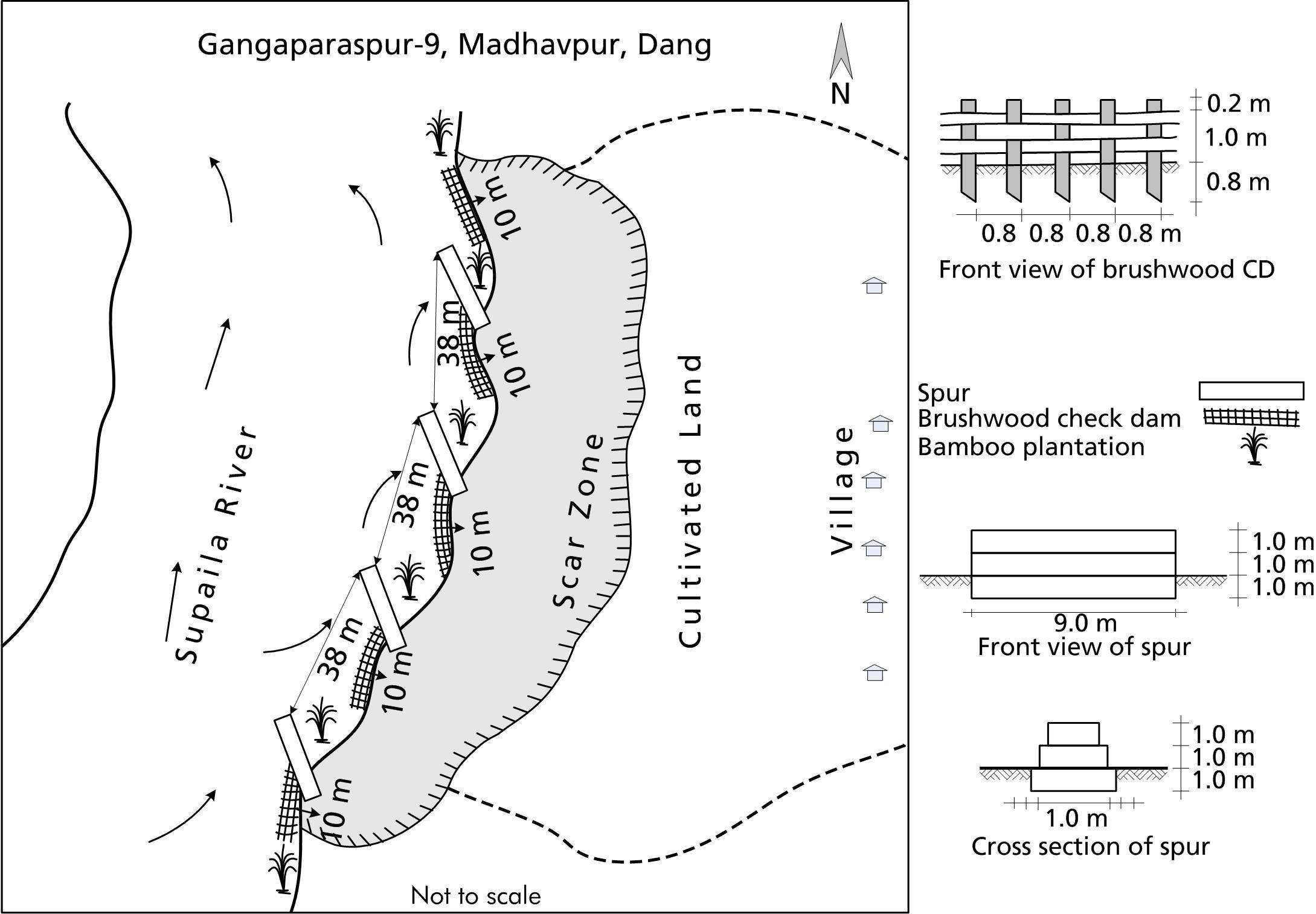
ข้อมูลจำเพาะด้านเทคนิค (แบบแปลนทางเทคนิคของเทคโนโลยี):
A low cost riverbank protection scheme that can be implemented using mostly local materials.
Technical knowledge required for field staff / advisors: low
Technical knowledge required for land users: moderate
Main technical functions: control of dispersed runoff: impede / retard, control of concentrated runoff: impede / retard
Secondary technical functions: improvement of ground cover, stabilisation of soil (eg by tree roots against land slides)
ผู้เขียน:
Bhojdeo Mandal, AK Thaku
4.2 ข้อมูลทั่วไปเกี่ยวกับการคำนวณปัจจัยนำเข้าและค่าใช้จ่าย
ให้ระบุว่าค่าใช้จ่ายและปัจจัยนำเข้าได้รับการคำนวณอย่างไร:
- ต่อพื้นที่ที่ใช้เทคโนโลยี
ระบุขนาดและหน่วยพื้นที่:
ha
ระบุสกุลเงินที่ใช้คำนวณค่าใช้จ่าย:
- USD
4.3 กิจกรรมเพื่อการจัดตั้ง
| กิจกรรม | Timing (season) | |
|---|---|---|
| 1. | Structural: Check dam construction | |
| 2. | Spur construction | |
| 3. | Vegetative: Pitting | |
| 4. | Bamboo planting | |
| 5. | Napier grass planting |
4.4 ค่าใช้จ่ายของปัจจัยนำเข้าที่จำเป็นสำหรับการจัดตั้ง
| ปัจจัยนำเข้า | หน่วย | ปริมาณ | ค่าใช้จ่ายต่อหน่วย | ค่าใช้จ่ายทั้งหมดต่อปัจจัยนำเข้า | %ของค่าใช้จ่ายที่ก่อให้เกิดขึ้นโดยผู้ใช้ที่ดิน | |
|---|---|---|---|---|---|---|
| แรงงาน | Construction of rivervbank protection | ha | 1.0 | 892.0 | 892.0 | 51.0 |
| อุปกรณ์ | Tools | ha | 1.0 | 21.0 | 21.0 | 51.0 |
| วัสดุด้านพืช | Napier grass, bamboo seedlings | ha | 1.0 | 14.0 | 14.0 | |
| วัสดุสำหรับก่อสร้าง | Stone | ha | 1.0 | 1281.0 | 1281.0 | 51.0 |
| วัสดุสำหรับก่อสร้าง | Bamboo poles | ha | 1.0 | 274.0 | 274.0 | 51.0 |
| วัสดุสำหรับก่อสร้าง | Wire for gabion box | ha | 1.0 | 1644.0 | 1644.0 | 51.0 |
| ค่าใช้จ่ายทั้งหมดของการจัดตั้งเทคโนโลยี | 4126.0 | |||||
| Total costs for establishment of the Technology in USD | 4126.0 | |||||
ถ้าผู้ใช้ที่ดินรับภาระน้อยกว่า 100% ของค่าใช้จ่าย ให้ระบุว่าใครเป็นผู้รับผิดชอบส่วนที่เหลือ:
The gabion boxes, the transportation costs, and some skilled labour by DSCO, Dang; whereas, the costs for the tools, local materials, and all of the unskilled labour were borne by the local community
4.5 การบำรุงรักษาสภาพหรือกิจกรรมที่เกิดขึ้นเป็นประจำ
| กิจกรรม | ช่วงระยะเวลา/ความถี่ | |
|---|---|---|
| 1. | Structural: Verify the integrity of the spurs and check dams; fortify or repair as needed. | |
| 2. | Vegetative: Maintenance costs cover only replacement and maintenance to be done by the local community for a few years until the vegetative structures are well established at the site. | |
| 3. | VegetativeCheck to see that the Napier grass seedlings have taken root; add additional plants as needed. |
4.6 ค่าใช้จ่ายของปัจจัยนำเข้าและกิจกรรมที่เกิดขึ้นเป็นประจำที่ต้องการการบำรุงรักษา (ต่อปี)
| ปัจจัยนำเข้า | หน่วย | ปริมาณ | ค่าใช้จ่ายต่อหน่วย | ค่าใช้จ่ายทั้งหมดต่อปัจจัยนำเข้า | %ของค่าใช้จ่ายที่ก่อให้เกิดขึ้นโดยผู้ใช้ที่ดิน | |
|---|---|---|---|---|---|---|
| แรงงาน | Fortify and reapir check dams | ha | 1.0 | 52.0 | 52.0 | 100.0 |
| วัสดุด้านพืช | Napier grass, bamboo seedlings | ha | 1.0 | 7.0 | 7.0 | 100.0 |
| วัสดุสำหรับก่อสร้าง | Bamboo poles for replacing | ha | 1.0 | 123.0 | 123.0 | 100.0 |
| ค่าใช้จ่ายทั้งหมดของการบำรุงรักษาสภาพเทคโนโลยี | 182.0 | |||||
| Total costs for maintenance of the Technology in USD | 182.0 | |||||
4.7 ปัจจัยสำคัญที่สุดที่มีผลกระทบต่อค่าใช้จ่าย
ปัจจัยสำคัญที่สุดที่มีผลกระทบต่อค่าใช้จ่ายต่างๆ:
The costs for the gabion boxes, the transportation costs, and some skilled labour, were borne by the DSCO, Dang; whereas, the costs for the tools, local materials, and all of the unskilled labour were borne by the local community.
All costs and amounts are rough estimates by the technicians and authors.
5. สิ่งแวดล้อมทางธรรมชาติและของมนุษย์
5.1 ภูมิอากาศ
ฝนประจำปี
- < 250 ม.ม.
- 251-500 ม.ม.
- 501-750 ม.ม.
- 751-1,000 ม.ม.
- 1,001-1,500 ม.ม.
- 1,501-2,000 ม.ม.
- 2,001-3,000 ม.ม.
- 3,001-4,000 ม.ม.
- > 4,000 ม.ม.
เขตภูมิอากาศเกษตร
- กึ่งชุ่มชื้น
Thermal climate class: tropics
5.2 สภาพภูมิประเทศ
ค่าเฉลี่ยความลาดชัน:
- ราบเรียบ (0-2%)
- ลาดที่ไม่ชัน (3-5%)
- ปานกลาง (6-10%)
- เป็นลูกคลื่น (11-15%)
- เป็นเนิน (16-30%)
- ชัน (31-60%)
- ชันมาก (>60%)
ธรณีสัณฐาน:
- ที่ราบสูง/ที่ราบ
- สันเขา
- ไหล่เขา
- ไหล่เนินเขา
- ตีนเนิน
- หุบเขา
ระดับความสูง:
- 0-100 เมตร
- 101-500 เมตร
- 501-1,000 เมตร
- 1,001-1,500 เมตร
- 1,501-2,000 เมตร
- 2,001-2,500 เมตร
- 2,501-3,000 เมตร
- 3,001-4,000 เมตร
- > 4,000 เมตร
5.3 ดิน
ค่าเฉลี่ยความลึกของดิน:
- ตื้นมาก (0-20 ซ.ม.)
- ตื้น (21-50 ซ.ม.)
- ลึกปานกลาง (51-80 ซ.ม.)
- ลึก (81-120 ซ.ม.)
- ลึกมาก (>120 ซ.ม.)
เนื้อดิน (ดินชั้นบน):
- หยาบ/เบา (ดินทราย)
อินทรียวัตถุในดิน:
- ต่ำ (<1%)
(ถ้ามี) ให้แนบคำอธิบายเรื่องดินแบบเต็มหรือระบุข้อมูลที่มีอยู่ เช่น ชนิดของดิน ค่า pH ของดินหรือความเป็นกรดของดิน ความสามารถในการแลกเปลี่ยนประจุบวก ไนโตรเจน ความเค็ม เป็นต้น:
Soil fertility is very low
Soil drainage / infiltration is good
Soil water storage capacity is very low
5.4 ความเป็นประโยชน์และคุณภาพของน้ำ
ระดับน้ำใต้ดิน:
5-50 เมตร
น้ำไหลบ่าที่ผิวดิน:
ไม่ดีหรือไม่มีเลย
คุณภาพน้ำ (ที่ยังไม่ได้บำบัด):
เป็นน้ำใช้เพื่อการเกษตรเท่านั้น (การชลประทาน)
5.5 ความหลากหลายทางชีวภาพ
ความหลากหลายทางชนิดพันธุ์:
- ต่ำ
5.6 ลักษณะของผู้ใช้ที่ดินที่นำเทคโนโลยีไปปฏิบัติใช้
แนวทางการตลาดของระบบการผลิต:
- เพื่อการยังชีพ (หาเลี้ยงตนเอง)
รายได้ที่มาจากนอกฟาร์ม:
- > 50% ของรายได้ทั้งหมด
ระดับของความมั่งคั่งโดยเปรียบเทียบ:
- จน
เป็นรายบุคคล/ครัวเรือน:
- กลุ่ม/ชุมชน
ระดับของการใช้เครื่องจักรกล:
- งานที่ใช้แรงกาย
- การใช้กำลังจากสัตว์
ระบุลักษณะอื่นๆที่เกี่ยวข้องของผู้ใช้ที่ดิน:
Population density: 100-200 persons/km2
Annual population growth: 2% - 3%
5.7 Average area of land used by land users applying the Technology
- < 0.5 เฮกตาร์
- 0.5-1 เฮกตาร์
- 1-2 เฮกตาร์
- 2-5 เฮกตาร์
- 5-15 เฮกตาร์
- 15-50 เฮกตาร์
- 50-100 เฮกตาร์
- 100-500 เฮกตาร์
- 500-1,000 เฮกตาร์
- 1,000-10,000 เฮกตาร์
- >10,000 เฮกตาร์
5.8 กรรมสิทธิ์ในที่ดิน สิทธิในการใช้ที่ดินและสิทธิในการใช้น้ำ
กรรมสิทธิ์ในที่ดิน:
- รายบุคคล ได้รับสิทธิครอบครอง
สิทธิในการใช้ที่ดิน:
- รายบุคคล
สิทธิในการใช้น้ำ:
- เกี่ยวกับชุมชน (ถูกจัดระเบียบ)
6. ผลกระทบและสรุปคำบอกกล่าว
6.1 ผลกระทบในพื้นที่ดำเนินการ (On-site) จากการใช้เทคโนโลยี
ผลกระทบทางด้านเศรษฐกิจและสังคม
การผลิต
การเสี่ยงต่อความล้มเหลวในการผลิต
รายได้และค่าใช้จ่าย
รายได้จากฟาร์ม
ความหลากหลายของแหล่งผลิตรายได้
ภาระงาน
ผลกระทบด้านสังคมวัฒนธรรมอื่น ๆ
ความมั่นคงด้านอาหาร / พึ่งตนเองได้
สถาบันของชุมชน
สถานการณ์ของกลุ่มด้อยโอกาส ทางด้านสังคมและเศรษฐกิจ
livelihood and human well-being
แสดงความคิดเห็น/ระบุ:
Agricultural land is conserved and production is increased
ผลกระทบด้านนิเวศวิทยา
ดิน
การสูญเสียดิน
ลดความเสี่ยงของภัยพิบัติ
ผลกระทบจากน้ำท่วม
ผลกระทบจากภัยแล้ง
ผลกระทบของพายุไซโคลน พายุฝน
6.2 ผลกระทบนอกพื้นที่ดำเนินการ (Off-site) จากการใช้เทคโนโลยี
น้ำท่วมพื้นที่ท้ายน้ำ
risk of flodd for public and private infrastructure, even at some distance from the site
6.3 การเผชิญและความตอบสนองของเทคโนโลยีต่อการเปลี่ยนแปลงสภาพภูมิอากาศที่ค่อยเป็นค่อยไป และสภาพรุนแรงของภูมิอากาศ / ภัยพิบัติ (ที่รับรู้ได้โดยผู้ใช้ที่ดิน)
การเปลี่ยนแปลงสภาพภูมิอากาศที่ค่อยเป็นค่อยไป
การเปลี่ยนแปลงสภาพภูมิอากาศที่ค่อยเป็นค่อยไป
| ฤดู | increase or decrease | เทคโนโลยีมีวิธีการรับมืออย่างไร | |
|---|---|---|---|
| อุณหภูมิประจำปี | เพิ่มขึ้น | ดี |
สภาพรุนแรงของภูมิอากาศ (ภัยพิบัติ)
ภัยพิบัติจากน้ำ
| เทคโนโลยีมีวิธีการรับมืออย่างไร | |
|---|---|
| น้ำท่วมตามปกติ (แม่น้ำ) | ไม่ค่อยดี |
แสดงความคิดเห็น:
Previously, the problem was tackled using traditional techniques alone but the results were not wholly satisfactory. After modifying (as discussed below) the structures are more robust and can withstand greater floods.
6.4 การวิเคราะห์ค่าใช้จ่ายและผลประโยชน์ที่ได้รับ
ผลประโยชน์ที่ได้รับเปรียบเทียบกับค่าใช้จ่ายในการจัดตั้งเป็นอย่างไร (จากมุมมองของผู้ใช้ที่ดิน)
ผลตอบแทนระยะสั้น:
ด้านบวกอย่างมาก
ผลตอบแทนระยะยาว:
ด้านบวกอย่างมาก
ผลประโยชน์ที่ได้รับเปรียบเทียบกับค่าใช้จ่ายในการบำรุงรักษาหรือต้นทุนที่เกิดขึ้นซ้ำอีก เป็นอย่างไร (จากมุมมองของผู้ใช้ที่ดิน)
ผลตอบแทนระยะสั้น:
ด้านบวก
ผลตอบแทนระยะยาว:
ด้านบวก
6.5 การปรับตัวของเทคโนโลยี
- > 50%
ถ้ามีข้อมูลให้บอกปริมาณด้วย (จำนวนของครัวเรือนหรือครอบคลุมพื้นที่):
47 households in an area of 10 ha
Of all those who have adopted the Technology, how many did so spontaneously, i.e. without receiving any material incentives/ payments?
- 0-10%
แสดงความคิดเห็น:
There is a little trend towards spontaneous adoption of the Technology
Comments on adoption trend: A community of 47 households has agreed to use this technology to help prevent soil erosion caused by flooding. The community had started to implement local measures to minimize riverbank cutting but the efforts were not successful. The systematic introduction of well-planned gabion spurs and bamboo check dams constructed using only locally available materials, has been successful. The community is convinced that this technology is beneficial and they will continue to propagate it themselves as needed.
6.7 จุดแข็ง / ข้อได้เปรียบ / โอกาสของเทคโนโลยี
| จุดแข็ง / ข้อได้เปรียบ / โอกาสในทัศนคติของผู้รวบรวมหรือวิทยากรหลัก |
|---|
|
The technology is low cost and can be implemented by the local community with the assistance of some technical support from the DSCO, Dang. How can they be sustained / enhanced? The DSCO, Dang, needs to continue to support the community in its efforts by technical backstopping, regular follow-up, and continued scaling up of the technology. |
|
The technology predominantly uses locally available materials. How can they be sustained / enhanced? Replication of this technology should be encouraged by the community as well as by the DSCO, Dang |
|
In the long run, vegetative structures help to propagate greenery and in so doing, they promote climate change adaptation and mitigation. How can they be sustained / enhanced? Communities should be made aware of the hazards of climate change and of what mitigation measures can be employed. |
|
Traditional measures used to help protect against flooding were very labour intensive and difficult to implement. This new method is low cost, easy to adopt, and sustainable. How can they be sustained / enhanced? Additional training with local communities can help to spread the expertise |
6.8 จุดอ่อน / ข้อเสียเปรียบ / ความเสี่ยงของเทคโนโลยีและวิธีการแก้ไข
| จุดอ่อน / ข้อเสียเปรียบ / ความเสี่ยงในทัศนคติของผู้รวบรวมหรือวิทยากรหลัก | มีวิธีการแก้ไขได้อย่างไร |
|---|---|
| Vegetative structures may not always take root as intended; the initial cost for the gabion cages can be high. | Try to implement the technology using vegetative measures |
| Despite the fact that the technology is known to be effective, it is not being widely implemented. | Communities need greater awareness; intensive extension is needed in order for the technology to have widespread acceptance. |
7. การอ้างอิงและการเชื่อมต่อ
7.1 วิธีการและแหล่งข้อมูล
7.2 การอ้างอิงถึงสิ่งตีพิมพ์
หัวข้อ, ผู้เขียน, ปี, หมายเลข ISBN:
District Forest Office, Dang; Soil Conservation and Watershed Management Measures and Low Cost Techniques; Environment Statistics of Nepal, Annual Report (2065/66)
ชื่อเรื่อง ผู้เขียน ปี ISBN:
Available at DSCO, Dang and DCSWM, Kathmandu
ลิงก์และโมดูล
ขยายทั้งหมด ย่อทั้งหมดลิงก์
ไม่มีลิงก์
โมดูล
ไม่มีโมดูล