Cercas vivas [Nicaragua]
- Creation:
- Update:
- Compiler: Heinner Hernández
- Editor: –
- Reviewer: Johanna Jacobi
Cercas vivas
technologies_4571 - Nicaragua
View sections
Expand all Collapse all1. General information
1.2 Contact details of resource persons and institutions involved in the assessment and documentation of the Technology
Name of project which facilitated the documentation/ evaluation of the Technology (if relevant)
Para el mandato de backstopping para le programa gestion comunitaria de la cuenca de Rio Dipilto en Nicaragua (Gestion comunitaria - Nicaragua)Name of the institution(s) which facilitated the documentation/ evaluation of the Technology (if relevant)
Swiss Agency for Development and Cooperation (DEZA / COSUDE / DDC / SDC) - SwitzerlandName of the institution(s) which facilitated the documentation/ evaluation of the Technology (if relevant)
Ministerio del Ambiente y los Recursos Naturales - Nicaragua (MARENA) - Nicaragua1.3 Conditions regarding the use of data documented through WOCAT
The compiler and key resource person(s) accept the conditions regarding the use of data documented through WOCAT:
Yes
1.4 Declaration on sustainability of the described Technology
Is the Technology described here problematic with regard to land degradation, so that it cannot be declared a sustainable land management technology?
No
2. Description of the SLM Technology
2.1 Short description of the Technology
Definition of the Technology:
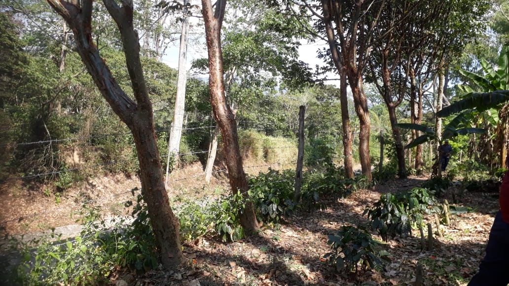
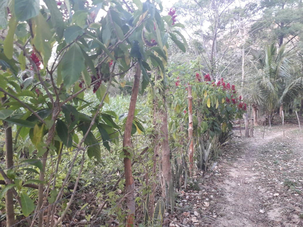
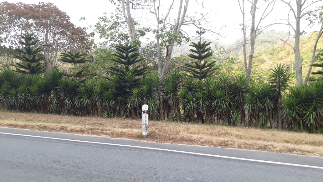
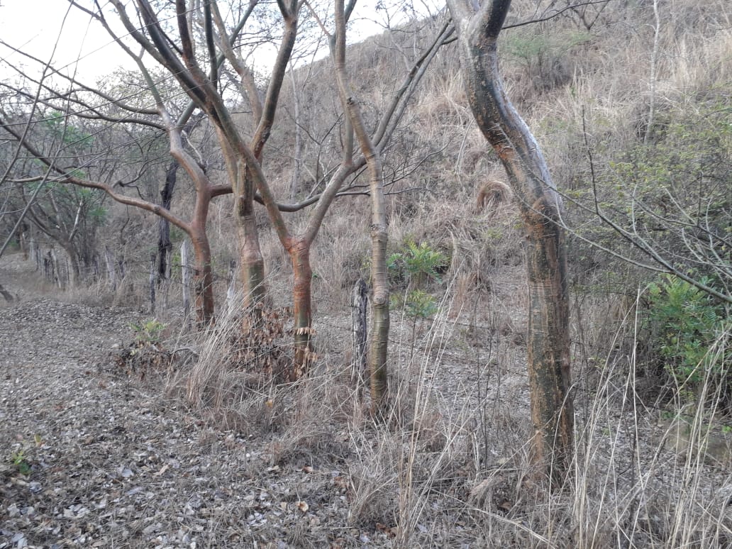
La tecnología es una linea de arboles y arbustos que sirve de cerca perimetral de protección a unidades de producción familiar, hogares, y/o división de microlotes productivos. Por su uso de material vegetativo ayuda la conservación de suelos y como barrera de protección a los cultivos.
2.2 Detailed description of the Technology
Description:
Las cercas vivas son una practica (tecnología) que sirve para delimitar linderos y/o hacer divisiones dentro de fincas (cafetaleras, ganaderas, forestales), y hogares. El Programa de Gestión Comunitaria de la Cuenca del Río Dipilto ha implementado mayormente esta práctica en fincas Ecoforestales y viviendas-patios. Recientemente se promueve su implementación para las fincas silvopastoriles y ganaderas dentro del área de la cuenca del Río Dipilto en la zona Norte de Nicaragua. La implementación de esta práctica implica la utilización de prendedizos (estacones de fácil rebrote de 2 metros de altura), plantulas forestales y/o frutales (todos de fácil adaptabilidad a las condiciones edafoclimáticas de la zona), así como uso de postes, alambres de púas y grapas. En la Finca El Carmen de la comunidad Los Planes (Dipilto-Nueva Segovia), las especies utilizadas para la implementación de la tecnología son: Jiñocuabo (Bursera simaruba), madero negro (Gliricidia sepium), izote (Yucca elephantipes), guaba (Inga edulis), caoba (Swietenia macrophylla) y cedro real (Cedrela odorata). Esta tecnología les gusta a los propietarios de las fincas, debido a que aparte de brindarle seguridad a su propiedad y mejorar las condiciones de microclima, suelo y habitats (para especies animales), le brinda mejor belleza escénica a su finca.
2.3 Photos of the Technology
Media Gallery
2.5 Country/ region/ locations where the Technology has been applied and which are covered by this assessment
Country:
Nicaragua
Region/ State/ Province:
Nueva Segovia
Further specification of location:
Dipilto
Specify the spread of the Technology:
- evenly spread over an area
If precise area is not known, indicate approximate area covered:
- 100-1,000 km2
Is/are the technology site(s) located in a permanently protected area?
Yes
If yes, specify:
Se encuentra dentro del Área Protegida Serranías Dipilto-Jalapa
Map
×2.6 Date of implementation
Indicate year of implementation:
2017
If precise year is not known, indicate approximate date:
- 10-50 years ago
2.7 Introduction of the Technology
Specify how the Technology was introduced:
- through land users' innovation
- through projects/ external interventions
Comments (type of project, etc.):
Esta practica la han venido realizando los productores desde hace unos 50 años, pero solo utilizaban plantas como cercas vivas; el PGCCRD apartir de 2017 les ha incentivado con la utilizacion de alambres de puas y plantas para mejorar esta practica.
3. Classification of the SLM Technology
3.1 Main purpose(s) of the Technology
- reduce, prevent, restore land degradation
- conserve ecosystem
- protect a watershed/ downstream areas – in combination with other Technologies
- preserve/ improve biodiversity
- reduce risk of disasters
- create beneficial economic impact
3.2 Current land use type(s) where the Technology is applied
Land use mixed within the same land unit:
Yes

Cropland
- Tree and shrub cropping
Tree and shrub cropping - Specify crops:
- coffee, shade grown
Number of growing seasons per year:
- 1
Specify:
Algunos cultivos son constantes (Musaceas)
Is intercropping practiced?
Yes
If yes, specify which crops are intercropped:
Cafe sembrado junto a musaceas y frutales, siendo el principal cultivo el cafe.

Forest/ woodlands
- (Semi-)natural forests/ woodlands
(Semi-)natural forests/ woodlands: Specify management type:
- Dead wood/ prunings removal
Type of (semi-)natural forest:
- subtropical mountain systems natural vegetation
Products and services:
- Fuelwood
- Nature conservation/ protection
- Protection against natural hazards
3.3 Has land use changed due to the implementation of the Technology?
Has land use changed due to the implementation of the Technology?
- No (Continue with question 3.4)
3.4 Water supply
Water supply for the land on which the Technology is applied:
- rainfed
3.5 SLM group to which the Technology belongs
- windbreak/ shelterbelt
- ecosystem-based disaster risk reduction
3.6 SLM measures comprising the Technology

vegetative measures
- V1: Tree and shrub cover
3.7 Main types of land degradation addressed by the Technology

soil erosion by water
- Wg: gully erosion/ gullying
- Wr: riverbank erosion

biological degradation
- Bc: reduction of vegetation cover
3.8 Prevention, reduction, or restoration of land degradation
Specify the goal of the Technology with regard to land degradation:
- prevent land degradation
- restore/ rehabilitate severely degraded land
4. Technical specifications, implementation activities, inputs, and costs
4.1 Technical drawing of the Technology
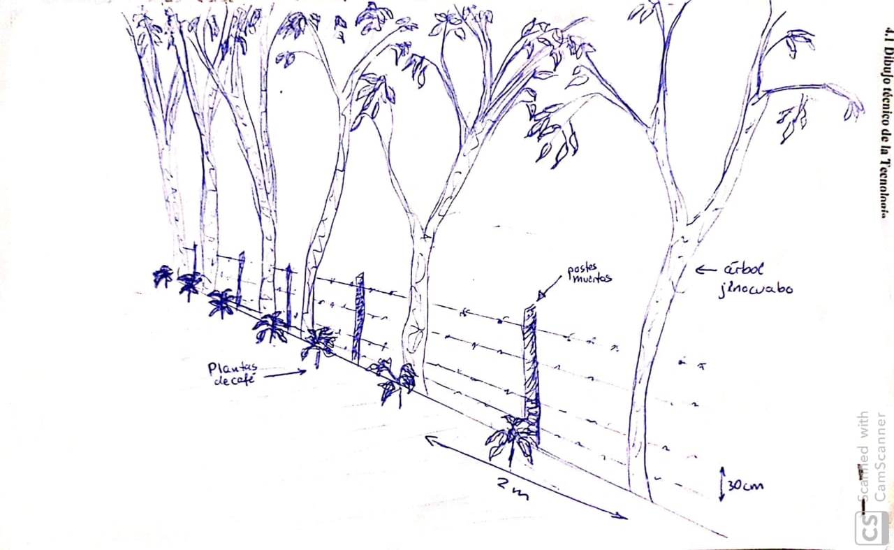
Technical specifications (related to technical drawing):
Distancia entre postes muertos: 2-3 metros; distancia entre prendones (arboles de jiñocuabo): 2 metros; distancia entre hilos de alambre: 0.30 mts.
Author:
Johanna Jacobi
Date:
21/03/2019
4.2 General information regarding the calculation of inputs and costs
Specify how costs and inputs were calculated:
- per Technology unit
Specify unit:
Metros lineales
Specify dimensions of unit (if relevant):
100 Metros lineales
other/ national currency (specify):
cordobas
If relevant, indicate exchange rate from USD to local currency (e.g. 1 USD = 79.9 Brazilian Real): 1 USD =:
33.13
Indicate average wage cost of hired labour per day:
190
4.3 Establishment activities
| Activity | Timing (season) | |
|---|---|---|
| 1. | Limpieza | |
| 2. | Busqueda de especies vegetales (prendones, plantas), y postes | |
| 3. | Ahoyado | |
| 4. | Poseteado | |
| 5. | Puesta de alambre de puas | |
| 6. | Plantacion de prendones y plantulas | Inicio de invierno |
4.4 Costs and inputs needed for establishment
| Specify input | Unit | Quantity | Costs per Unit | Total costs per input | % of costs borne by land users | |
|---|---|---|---|---|---|---|
| Labour | D/H | 7.0 | 190.0 | 1330.0 | 100.0 | |
| Equipment | Machete | Und | 1.0 | 150.0 | 150.0 | 100.0 |
| Equipment | Palin | Und | 1.0 | 270.0 | 270.0 | 100.0 |
| Equipment | martillo | Und | 1.0 | 200.0 | 200.0 | 100.0 |
| Plant material | Prendedizos | Und | 50.0 | 20.0 | 1000.0 | 100.0 |
| Plant material | Plantas forestales | Und | 30.0 | 15.0 | 450.0 | 100.0 |
| Construction material | Alambre de puas | Rollo | 1.0 | 1700.0 | 1700.0 | |
| Construction material | Grapas | Lbs | 2.0 | 30.0 | 60.0 | |
| Construction material | Postes | Und | 10.0 | 100.0 | 1000.0 | |
| Total costs for establishment of the Technology | 6160.0 | |||||
| Total costs for establishment of the Technology in USD | 185.93 | |||||
If land user bore less than 100% of costs, indicate who covered the remaining costs:
Las plantas forestales, grapas y alambre de púas lo facilitó el PGCCRD
Comments:
Las herramientas las posee el protagonista, y estas son de uso permanente en sus fincas; aqui se cuantifica su costo por si un productor no las posee y tiene que comprarlas.
4.5 Maintenance/ recurrent activities
| Activity | Timing/ frequency | |
|---|---|---|
| 1. | Limpieza de maleza | Cuando sale el invierno. Anualmente |
| 2. | Rondas de proteccion | Cuando sale el invierno. Anualmente |
| 3. | Poda | Cuando inicia el invierno. Cada 3 años (segun la especie) |
| 4. | Reposteo | Cuando sale el invierno. una vez (despues de dos años de estavlecida la practica) |
4.6 Costs and inputs needed for maintenance/ recurrent activities (per year)
| Specify input | Unit | Quantity | Costs per Unit | Total costs per input | % of costs borne by land users | |
|---|---|---|---|---|---|---|
| Labour | D/H | 2.0 | 190.0 | 380.0 | ||
| Plant material | Grapas | Lbs | 1.0 | 30.0 | 30.0 | 100.0 |
| Plant material | Postes | Und | 4.0 | 100.0 | 400.0 | 100.0 |
| Total costs for maintenance of the Technology | 810.0 | |||||
| Total costs for maintenance of the Technology in USD | 24.45 | |||||
Comments:
Los costos de reposteo (mantenimiento de la cerca viva), se realiza si esta la amerita.
4.7 Most important factors affecting the costs
Describe the most determinate factors affecting the costs:
Los costos son afectados debido al precio de la mano de obra; asi mismo porque en la zona alta de la cuenca del Río Dipilto, no hay postes, estos tienen que ser llevados desde la zona media de la cuenca, o desde municipios vecinos del corredor seco; lo que se altera por el costo de transporte.
5. Natural and human environment
5.1 Climate
Annual rainfall
- < 250 mm
- 251-500 mm
- 501-750 mm
- 751-1,000 mm
- 1,001-1,500 mm
- 1,501-2,000 mm
- 2,001-3,000 mm
- 3,001-4,000 mm
- > 4,000 mm
Agro-climatic zone
- sub-humid
5.2 Topography
Slopes on average:
- flat (0-2%)
- gentle (3-5%)
- moderate (6-10%)
- rolling (11-15%)
- hilly (16-30%)
- steep (31-60%)
- very steep (>60%)
Landforms:
- plateau/plains
- ridges
- mountain slopes
- hill slopes
- footslopes
- valley floors
Altitudinal zone:
- 0-100 m a.s.l.
- 101-500 m a.s.l.
- 501-1,000 m a.s.l.
- 1,001-1,500 m a.s.l.
- 1,501-2,000 m a.s.l.
- 2,001-2,500 m a.s.l.
- 2,501-3,000 m a.s.l.
- 3,001-4,000 m a.s.l.
- > 4,000 m a.s.l.
Indicate if the Technology is specifically applied in:
- not relevant
5.3 Soils
Soil depth on average:
- very shallow (0-20 cm)
- shallow (21-50 cm)
- moderately deep (51-80 cm)
- deep (81-120 cm)
- very deep (> 120 cm)
Soil texture (topsoil):
- coarse/ light (sandy)
Soil texture (> 20 cm below surface):
- coarse/ light (sandy)
Topsoil organic matter:
- medium (1-3%)
5.4 Water availability and quality
Ground water table:
on surface
Availability of surface water:
good
Water quality (untreated):
poor drinking water (treatment required)
Water quality refers to:
surface water
Is water salinity a problem?
No
Is flooding of the area occurring?
No
5.5 Biodiversity
Species diversity:
- high
Habitat diversity:
- high
Comments and further specifications on biodiversity:
En la finca El Carmen existe un area de 3.52 hectáreas donde se encuentra un bosque virgen de conservación.
5.6 Characteristics of land users applying the Technology
Sedentary or nomadic:
- Sedentary
Market orientation of production system:
- mixed (subsistence/ commercial)
Off-farm income:
- less than 10% of all income
Relative level of wealth:
- average
Individuals or groups:
- individual/ household
Level of mechanization:
- manual work
Gender:
- men
Age of land users:
- youth
Indicate other relevant characteristics of the land users:
La finca El Carmen la administra el hijo de la propietaria.
5.7 Average area of land used by land users applying the Technology
- < 0.5 ha
- 0.5-1 ha
- 1-2 ha
- 2-5 ha
- 5-15 ha
- 15-50 ha
- 50-100 ha
- 100-500 ha
- 500-1,000 ha
- 1,000-10,000 ha
- > 10,000 ha
Is this considered small-, medium- or large-scale (referring to local context)?
- medium-scale
Comments:
El tamaño de la finca es de 21.13 hectareas
5.8 Land ownership, land use rights, and water use rights
Land ownership:
- individual, titled
Land use rights:
- individual
Water use rights:
- individual
Are land use rights based on a traditional legal system?
Yes
Specify:
Escritura publica
5.9 Access to services and infrastructure
health:
- poor
- moderate
- good
education:
- poor
- moderate
- good
technical assistance:
- poor
- moderate
- good
employment (e.g. off-farm):
- poor
- moderate
- good
markets:
- poor
- moderate
- good
energy:
- poor
- moderate
- good
roads and transport:
- poor
- moderate
- good
drinking water and sanitation:
- poor
- moderate
- good
financial services:
- poor
- moderate
- good
6. Impacts and concluding statements
6.1 On-site impacts the Technology has shown
Socio-cultural impacts
conflict mitigation
Quantity before SLM:
-1
Quantity after SLM:
3
Comments/ specify:
Por la delimitacion ya no tiene conflictos vecinales
Seguridad de la finca (evita ingreso de personas ajenas y por ello se evita daños a la propiedad y robo de cultivos)
Quantity before SLM:
-1
Quantity after SLM:
3
Comments/ specify:
Antes de la tecnologia, personas ajenas, robaban cultivos (cafe y frutas)
Ecological impacts
Biodiversity: vegetation, animals
Vegetation cover
biomass/ above ground C
plant diversity
habitat diversity
Climate and disaster risk reduction
landslides/ debris flows
drought impacts
fire risk
Comments/ specify:
Se limpia (ronda) la cerca viva, es una medida de prevencion de incendios forestales
micro-climate
6.3 Exposure and sensitivity of the Technology to gradual climate change and climate-related extremes/ disasters (as perceived by land users)
Gradual climate change
Gradual climate change
| Season | increase or decrease | How does the Technology cope with it? | |
|---|---|---|---|
| annual temperature | increase | well | |
| annual rainfall | increase | well |
Climate-related extremes (disasters)
Meteorological disasters
| How does the Technology cope with it? | |
|---|---|
| tropical storm | well |
| extra-tropical cyclone | well |
Climatological disasters
| How does the Technology cope with it? | |
|---|---|
| drought | very well |
| forest fire | well |
Hydrological disasters
| How does the Technology cope with it? | |
|---|---|
| landslide | very well |
Biological disasters
| How does the Technology cope with it? | |
|---|---|
| epidemic diseases | very well |
6.4 Cost-benefit analysis
How do the benefits compare with the establishment costs (from land users’ perspective)?
Short-term returns:
slightly positive
Long-term returns:
positive
How do the benefits compare with the maintenance/ recurrent costs (from land users' perspective)?
Short-term returns:
neutral/ balanced
Long-term returns:
positive
6.5 Adoption of the Technology
- > 50%
Of all those who have adopted the Technology, how many did so spontaneously, i.e. without receiving any material incentives/ payments?
- 51-90%
6.6 Adaptation
Has the Technology been modified recently to adapt to changing conditions?
No
6.7 Strengths/ advantages/ opportunities of the Technology
| Strengths/ advantages/ opportunities in the land user’s view |
|---|
| Seguridad para la propiedad |
| Evita derrumbes |
| Puede generar ingresos por venta de frutas, prendones para reforestar otras areas |
| Banco de alimentos para aves |
| Seguridad alimentaria para la familia (los frutos sirven de alimento para la familia) |
| Strengths/ advantages/ opportunities in the compiler’s or other key resource person’s view |
|---|
| Sirve para leña (las ramas secas) |
| Captura de carbono |
| Purificacion del aire |
| Repelentes naturales |
6.8 Weaknesses/ disadvantages/ risks of the Technology and ways of overcoming them
| Weaknesses/ disadvantages/ risks in the land user’s view | How can they be overcome? |
|---|---|
| Altos costos de mano obra | |
| Costo de materiales externos (alambre de puas, grapas y postes), se incrementa por el costo del transporte, |
| Weaknesses/ disadvantages/ risks in the compiler’s or other key resource person’s view | How can they be overcome? |
|---|---|
| Los animales silvestres se pueden ver afectados si se hieren en las puas del alambre. |
7. References and links
7.1 Methods/ sources of information
- field visits, field surveys
1 (Finca El Carmen, comunidad Los Planes; Dipilto-Nueva Segovia)
- interviews with land users
1 (Roberto de Jesus Lopez Olivas)
- interviews with SLM specialists/ experts
2 (Jader Alberto Luquez Gonzalez)
When were the data compiled (in the field)?
21/03/2019
7.3 Links to relevant online information
Title/ description:
Brochoure Barreras vivas
URL:
http://www.inta.gob.ni/biblioteca/images/pdf/plegables/Brochure%20barreras%20vivas.pdf
Title/ description:
Las cercas vivas en fincas ganaderas
URL:
http://repositorio.uca.edu.ni/2227/1/las_cercas_vivas_en_las_fincas_ganaderas.pdf
Title/ description:
Establecimiento y manejo de las cercas vivas de Madero Negro
URL:
http://www.funica.org.ni/docs/conser_sueyagua_45.pdf
Title/ description:
Inventario de practicas t tecnologias
URL:
http://sidocfeminista.org/images/books/05090/05090_00.pdf
Links and modules
Expand all Collapse allLinks
No links
Modules
No modules