Sub-surface water harvesting for an efficient use of water resources [Pakistan]
- Creation:
- Update:
- Compiler: Eveline Studer
- Editor: Munawar Khan
- Reviewers: Hanspeter Liniger, Nicole Harari, Alexandra Gavilano
Infiltration gallery
technologies_540 - Pakistan
View sections
Expand all Collapse all1. General information
1.2 Contact details of resource persons and institutions involved in the assessment and documentation of the Technology
Key resource person(s)
Engineer-Water conservation:
Muhammad Khan
Water for Livelihoods Project-Intercooperation Pakistan
Pakistan
Water Management specilist:
Rehman Nasib-ur
On-Farm water managment, department of Agriculture
Pakistan
Name of project which facilitated the documentation/ evaluation of the Technology (if relevant)
Book project: where people and their land are safer - A Compendium of Good Practices in Disaster Risk Reduction (DRR) (where people and their land are safer)Name of the institution(s) which facilitated the documentation/ evaluation of the Technology (if relevant)
HELVETAS (Swiss Intercooperation)1.3 Conditions regarding the use of data documented through WOCAT
The compiler and key resource person(s) accept the conditions regarding the use of data documented through WOCAT:
Yes
1.4 Declaration on sustainability of the described Technology
Is the Technology described here problematic with regard to land degradation, so that it cannot be declared a sustainable land management technology?
No
Comments:
The technology promoted sunstainable water conservation. It is cost effective and requires no external energy supply as it is based on gravity flow.
1.5 Reference to Questionnaire(s) on SLM Approaches (documented using WOCAT)
Water Use Management Plan (WUMP) [Pakistan]
The overall purpose of WUMP is to compile an inventory of available water ressources in a particular geographical or administrative area, to identify communities' priorities in order to achieve an effective, equitable and efficient use of water resources at local level. This approach promotes a participatory and inclusive analysis and …
- Compiler: Eveline Studer
2. Description of the SLM Technology
2.1 Short description of the Technology
Definition of the Technology:
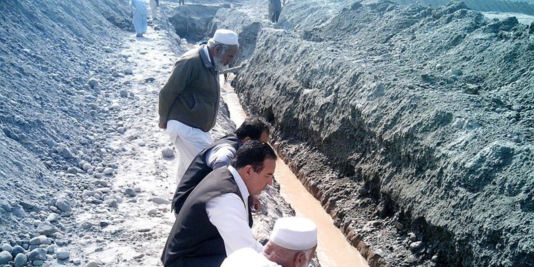
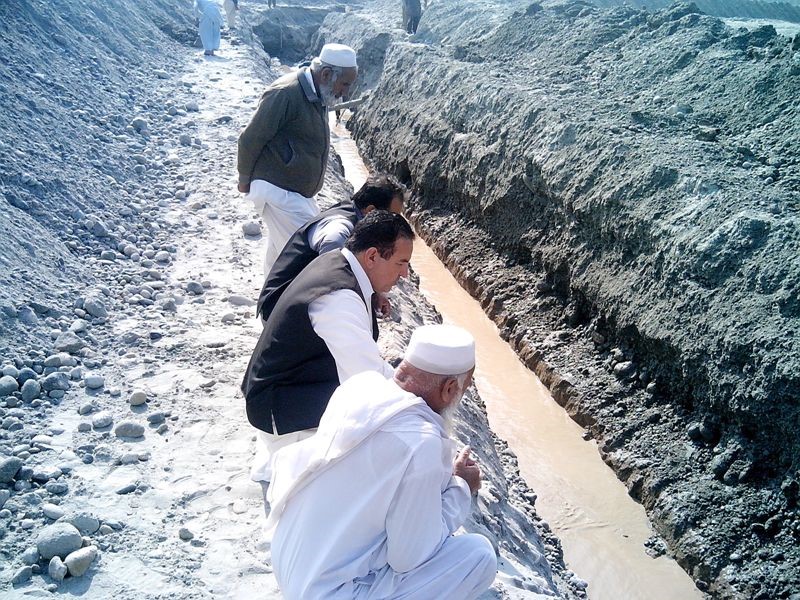
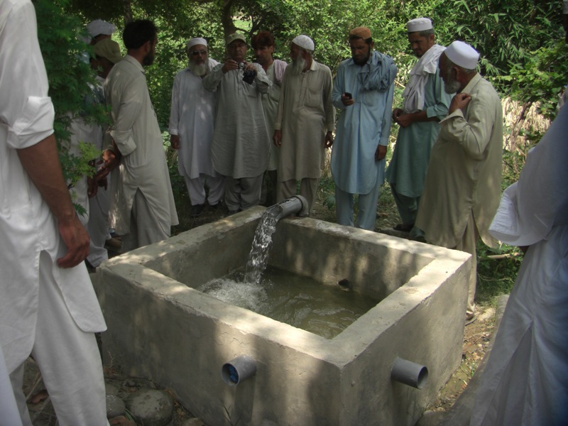
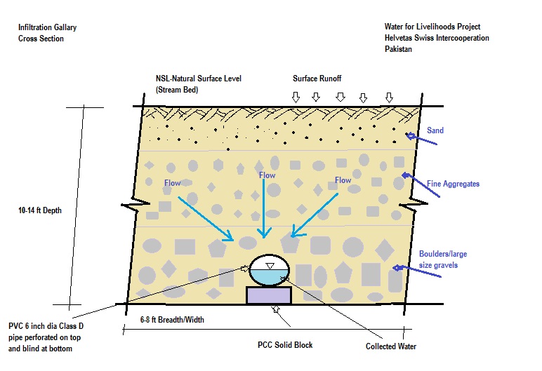
The purpose of this water harvesting technology is to capture, collect and distribute sub-surface water. First, an infiltration gallery is developed, which allows the percolation and collection of sub-surface water through perforated pipes at a depth of approximately 3-4.5 metres. Sub-surface water is filtered by gravel/sand underground and infiltrates into the gallery. The harvested water is used for household needs as well as for livestock and irrigation through gravity flow.
2.2 Detailed description of the Technology
Description:
This method is applied in areas with low rainfall, where soils have a sandy-gravelly texture and where the sub-surface water can not percolate deeply, but instead flows laterally in shallow sub-surface channels. The technology consists of the following main elements: filtration materials (sand / gravel), collection chambers, perforated pipes, conveyance lines made from solid blocks, and storage tanks. Construction includes the following main activities and inputs:
• Excavation of rectangular trenches with machinery or by hand
• Construction of a solid base line with PCC (plain cement concrete) blocks on the top of boulders
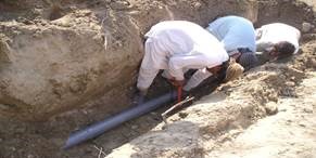
• Installation of perforated and blind pipes - and storage tanks where necessary
• Coverage of the trench first with boulders and then sand on top.
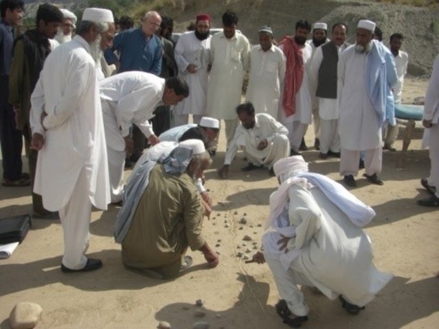
Once the gallery is constructed there is no further need for intervention; this means that maintenance costs for the user (farmer, households of the local community) are minimal. Traditionally, the technology has been implemented by local farmers for many years. Where improvements are required, support by local technicians is provided. The technology is based on local knowledge, and locally available construction materials. The method is technically simple, cost-effective and environmentally friendly. Farmers and other users consider this technology as very efficient as there is no need for external energy supply, and it can be easily replicated. Furthermore, it requires a minimum of external construction material and the operation costs are minimal. The captured water is filtered through the subsurface layers and - as long as there is no specific external contamination - it is safe and can be used for various purposes as already noted. This extra water supply is particularly effective for irrigation, contributing to increased production and allowing diversification of crop production (potentially also of high value crops), thereby improving the livelihoods of remote rural communities. The primary impact of this technology is to reduce risks related to droughts or water scarcity as natural phenomena or consequences of climate change effects. Additionally infiltration of water into the galleries reduces surface erosion of fertile soil, hence it lessens soil degradation.
2.3 Photos of the Technology
Media Gallery
2.5 Country/ region/ locations where the Technology has been applied and which are covered by this assessment
Country:
Pakistan
Region/ State/ Province:
Southern Khyber Pakhtunkhwa
Further specification of location:
Karak, Laki Marwat & Dera Ismail Khan
Specify the spread of the Technology:
- applied at specific points/ concentrated on a small area
Comments:
This technology is suitable for area with little slope to retain a maximum amount of water. when the stream bed has a higher gravel content, it provides more water. The technology is suitable for strata with no/ low vertical percolation, such as underlying hard rocks.
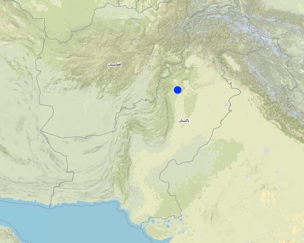
Map
×2.6 Date of implementation
Indicate year of implementation:
2013
2.7 Introduction of the Technology
Specify how the Technology was introduced:
- as part of a traditional system (> 50 years)
Comments (type of project, etc.):
Water for Livelihoods Project (rural development project)
3. Classification of the SLM Technology
3.1 Main purpose(s) of the Technology
- improve production
- reduce, prevent, restore land degradation
- protect a watershed/ downstream areas – in combination with other Technologies
- reduce risk of disasters
- adapt to climate change/ extremes and its impacts
- create beneficial economic impact
- create beneficial social impact
3.2 Current land use type(s) where the Technology is applied

Cropland
- Annual cropping
- Tree and shrub cropping
Annual cropping - Specify crops:
- cereals - maize
- cereals - millet
- vegetables - other
- wheat, tomatoes
Tree and shrub cropping - Specify crops:
- mango, mangosteen, guava
Number of growing seasons per year:
- 2
Specify:
Rabi (October to March) & Kharif (April to September) season
Comments:
Main crops (cash and food crops):
- Wheat, maize/corn, millet
- Tomato and other vegetables
- Fruit trees: guava etc.
As a result of the introdued technology, farmers can now produce multiple crops and have increased the cropping efficiency.
3.3 Has land use changed due to the implementation of the Technology?
Has land use changed due to the implementation of the Technology?
- Yes (Please fill out the questions below with regard to the land use before implementation of the Technology)
Cropland
- Annual cropping
Comments:
Prior to the establishment of the infiltration gallery, cropland was mainly rain-fed and only a single crop was produced with 50 % cropping efficiency.
The cropping efficiency increased up to 150 % (growing 3 crops instead of 1 crop in a year).
3.4 Water supply
Water supply for the land on which the Technology is applied:
- rainfed
Comments:
- The technology is simple and not costly to establish.
- It further contributes to adapt to climate change, especially in areas where water becomes increasingly scarce.
3.5 SLM group to which the Technology belongs
- water harvesting
- irrigation management (incl. water supply, drainage)
- ground water management
3.6 SLM measures comprising the Technology

structural measures
- S3: Graded ditches, channels, waterways
- S7: Water harvesting/ supply/ irrigation equipment
- S10: Energy saving measures
3.7 Main types of land degradation addressed by the Technology

soil erosion by water
- Wt: loss of topsoil/ surface erosion
3.8 Prevention, reduction, or restoration of land degradation
Specify the goal of the Technology with regard to land degradation:
- reduce land degradation
- adapt to land degradation
Comments:
Further the technology contributes to reduce risks and losses linked to droughts as natural hazard and/or the effect of climate change.
4. Technical specifications, implementation activities, inputs, and costs
4.1 Technical drawing of the Technology
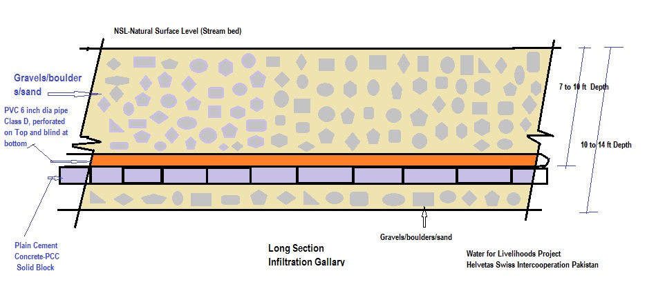
Technical specifications (related to technical drawing):
Dimensions of the cross section:
- Depth: 10 to 15 feet, width: 6 to 8 feet, length: 300 to 1000 feet
- Slope: 3% on 200 feet
- Volume of storage tank: 30 x 30 x 4 feet
Author:
Munawar Khan & Khan Muhammad
Date:
2013
Author:
Munawar Khan & Khan Muhammad
Date:
2013
4.2 General information regarding the calculation of inputs and costs
Specify how costs and inputs were calculated:
- per Technology unit
Specify unit:
Infiltration gallery: conveyance, collection chamber and tank
Specify dimensions of unit (if relevant):
600 feet gallery (including 3600 feet conveyance lineconveyance line to the tank/water user's end point (adduction section without wholes for infiltration))
Specify currency used for cost calculations:
- USD
Indicate average wage cost of hired labour per day:
Skilled labour: 12 USD/day, unskilled labour: 6 USD /day
4.3 Establishment activities
| Activity | Timing (season) | |
|---|---|---|
| 1. | Excavation | 2 weeks |
| 2. | Dry stone packing | 1 week |
| 3. | Laying of PCC block (plain cement concrete) | 2-3 days |
| 4. | Installation & fixing of perforated pipes (6" diameter) | 2-3 days |
| 5. | Establishement of filtration media (boulder, gravel, sand packing)at gallery's end point/ water user's access point (if required) material: concrete | 2 weeks |
| 6. | Construction of water collecting chamber | 1 week |
| 7. | Convayance line (3" diameter) | 3 weeks |
| 8. | construction of storage tank (if required) | 4 weeks as parallel activity |
Comments:
Totally, it takes 3 months to complete the construction of the infiltration gallery unit (600 feet) including the conveyance line and storage tank. Some of the activities can be carried out in parallel.
4.4 Costs and inputs needed for establishment
| Specify input | Unit | Quantity | Costs per Unit | Total costs per input | % of costs borne by land users | |
|---|---|---|---|---|---|---|
| Labour | Skilled Labour | Days | 109.0 | 12.0 | 1308.0 | |
| Labour | Un-Skilled Labour | Days | 465.0 | 6.0 | 2790.0 | 100.0 |
| Equipment | Machinary (Excavator) | Hour | 118.0 | 25.0 | 2950.0 | |
| Construction material | Bricks (Number) | 1000 | 12.5 | 95.0 | 1187.5 | |
| Construction material | PCC blocks, rough stone (cubic foot) | 100 | 44.5 | 50.0 | 2225.0 | |
| Construction material | Cement (50 kg bags) | 50 | 275.0 | 5.0 | 1375.0 | |
| Construction material | sand, crush, boulder, gravel (cubic foot) | 100 | 63.0 | 35.0 | 2205.0 | |
| Other | PVC pipe perforated (6" diameter filter section class D) (ft) | 1 | 590.0 | 5.0 | 2950.0 | |
| Other | PVC blind pipe (3" diameter class B) (ft) | 1 | 3600.0 | 1.0 | 3600.0 | |
| Total costs for establishment of the Technology | 20590.5 | |||||
| Total costs for establishment of the Technology in USD | 20590.5 | |||||
If land user bore less than 100% of costs, indicate who covered the remaining costs:
Project / Government partner - i.e. on Farm Water Management department & public Health engineering Department, shared the cost at the ratio of 80 % : 20 %.
Comments:
Total cost of the technology is basically proportional to the length of gallery and futher dependson the size of the storage tank.
4.5 Maintenance/ recurrent activities
Comments:
This technology is based on a single cost investment. Except minor repairs of storage tank, there are no relevant maintanance costs.
The filter function of the boulder layer and the perforated pipes reduce sedimentation problems. Minor amounts of silt and fine sediments in the storage tank can be removed with minor effort by the user (unskilled labo no tools required),
4.7 Most important factors affecting the costs
Describe the most determinate factors affecting the costs:
- Length of the infiltration gallery
- Length of the conveyance line
- Size of storage tank (not alway included)
5. Natural and human environment
5.1 Climate
Annual rainfall
- < 250 mm
- 251-500 mm
- 501-750 mm
- 751-1,000 mm
- 1,001-1,500 mm
- 1,501-2,000 mm
- 2,001-3,000 mm
- 3,001-4,000 mm
- > 4,000 mm
Specify average annual rainfall (if known), in mm:
300.00
Specifications/ comments on rainfall:
rains in both season (monsoon & winter)
Indicate the name of the reference meteorological station considered:
Kohat & Bannu & DIKhan Met Department Automatic Weather Station
Agro-climatic zone
- semi-arid
Min. /max. temperatures: 9°C / 42°C
5.2 Topography
Slopes on average:
- flat (0-2%)
- gentle (3-5%)
- moderate (6-10%)
- rolling (11-15%)
- hilly (16-30%)
- steep (31-60%)
- very steep (>60%)
Landforms:
- plateau/plains
- ridges
- mountain slopes
- hill slopes
- footslopes
- valley floors
Altitudinal zone:
- 0-100 m a.s.l.
- 101-500 m a.s.l.
- 501-1,000 m a.s.l.
- 1,001-1,500 m a.s.l.
- 1,501-2,000 m a.s.l.
- 2,001-2,500 m a.s.l.
- 2,501-3,000 m a.s.l.
- 3,001-4,000 m a.s.l.
- > 4,000 m a.s.l.
Indicate if the Technology is specifically applied in:
- not relevant
5.3 Soils
Soil depth on average:
- very shallow (0-20 cm)
- shallow (21-50 cm)
- moderately deep (51-80 cm)
- deep (81-120 cm)
- very deep (> 120 cm)
Soil texture (topsoil):
- coarse/ light (sandy)
Soil texture (> 20 cm below surface):
- coarse/ light (sandy)
Topsoil organic matter:
- medium (1-3%)
5.4 Water availability and quality
Ground water table:
5-50 m
Availability of surface water:
medium
Water quality (untreated):
good drinking water
Is water salinity a problem?
No
Is flooding of the area occurring?
Yes
Comments and further specifications on water quality and quantity:
Due to floods in monsoon season, the discharge capacity increases.
5.5 Biodiversity
Species diversity:
- medium
Habitat diversity:
- low
5.6 Characteristics of land users applying the Technology
Sedentary or nomadic:
- Sedentary
Market orientation of production system:
- subsistence (self-supply)
- mixed (subsistence/ commercial)
Off-farm income:
- > 50% of all income
Relative level of wealth:
- poor
Individuals or groups:
- individual/ household
- groups/ community
Level of mechanization:
- manual work
- animal traction
Gender:
- women
- men
Age of land users:
- middle-aged
5.7 Average area of land used by land users applying the Technology
- < 0.5 ha
- 0.5-1 ha
- 1-2 ha
- 2-5 ha
- 5-15 ha
- 15-50 ha
- 50-100 ha
- 100-500 ha
- 500-1,000 ha
- 1,000-10,000 ha
- > 10,000 ha
Is this considered small-, medium- or large-scale (referring to local context)?
- small-scale
5.8 Land ownership, land use rights, and water use rights
Land ownership:
- individual, titled
Land use rights:
- communal (organized)
- individual
Water use rights:
- communal (organized)
- individual
5.9 Access to services and infrastructure
health:
- poor
- moderate
- good
education:
- poor
- moderate
- good
technical assistance:
- poor
- moderate
- good
employment (e.g. off-farm):
- poor
- moderate
- good
markets:
- poor
- moderate
- good
energy:
- poor
- moderate
- good
roads and transport:
- poor
- moderate
- good
drinking water and sanitation:
- poor
- moderate
- good
financial services:
- poor
- moderate
- good
6. Impacts and concluding statements
6.1 On-site impacts the Technology has shown
Socio-economic impacts
Production
crop production
Comments/ specify:
increased crop production efficiency due to additional and year-round water avalability for irrigation.
crop quality
Comments/ specify:
with the additional water for irrigation, water is no limiting factor anymore, with allows an improved crop productin in terms of quality and quantity.
fodder production
Quantity before SLM:
-1
Quantity after SLM:
1
product diversity
Quantity before SLM:
-1
Quantity after SLM:
2
Comments/ specify:
with additional water through irrigation, additional crops might be cultivated, which contributes to production and income diversification.
production area
Comments/ specify:
with additional water through irrigation, additional areas can be used for agriculture.
Water availability and quality
drinking water availability
drinking water quality
Quantity before SLM:
0
Quantity after SLM:
2
water availability for livestock
irrigation water availability
Quantity before SLM:
-2
Quantity after SLM:
3
irrigation water quality
Quantity before SLM:
0
Quantity after SLM:
3
demand for irrigation water
Comments/ specify:
the technology directly contributes to additional water for irrigation
Income and costs
farm income
Comments/ specify:
Irrigation allows improved, diversified crop production. Water access for lifestock ensures animals health. Both crucial aspects for the income of local farmers
diversity of income sources
Quantity before SLM:
0
Quantity after SLM:
1
Socio-cultural impacts
food security/ self-sufficiency
Quantity before SLM:
-1
Quantity after SLM:
2
land use/ water rights
Quantity before SLM:
0
Quantity after SLM:
2
Ecological impacts
Water cycle/ runoff
harvesting/ collection of water
Quantity before SLM:
0
Quantity after SLM:
2
Biodiversity: vegetation, animals
Vegetation cover
Quantity before SLM:
0
Quantity after SLM:
1
Climate and disaster risk reduction
drought impacts
Comments/ specify:
reduced consequences of droughts/water scarcity, in terms of production failure/lost harvest and reduced production
6.2 Off-site impacts the Technology has shown
water availability
reliable and stable stream flows in dry season
6.3 Exposure and sensitivity of the Technology to gradual climate change and climate-related extremes/ disasters (as perceived by land users)
Gradual climate change
Gradual climate change
| Season | increase or decrease | How does the Technology cope with it? | |
|---|---|---|---|
| annual rainfall | increase | well | |
| seasonal rainfall | summer | increase | well |
Climate-related extremes (disasters)
Climatological disasters
| How does the Technology cope with it? | |
|---|---|
| drought | well |
6.4 Cost-benefit analysis
How do the benefits compare with the establishment costs (from land users’ perspective)?
Short-term returns:
positive
Long-term returns:
very positive
How do the benefits compare with the maintenance/ recurrent costs (from land users' perspective)?
Short-term returns:
positive
Long-term returns:
positive
6.5 Adoption of the Technology
- 1-10%
Of all those who have adopted the Technology, how many did so spontaneously, i.e. without receiving any material incentives/ payments?
- 11-50%
6.6 Adaptation
Has the Technology been modified recently to adapt to changing conditions?
Yes
If yes, indicate to which changing conditions it was adapted:
- climatic change/ extremes
Specify adaptation of the Technology (design, material/ species, etc.):
Design of infiltration galleries (diameter of pipes, size of perforation, slope etc.) was adjusted to local conditions including the consideration of local rainfall / amount of water.
6.7 Strengths/ advantages/ opportunities of the Technology
| Strengths/ advantages/ opportunities in the land user’s view |
|---|
| Low cost measure, which requires only a one-time investment, low/no repair or maintenance costs are required. |
| Well assimilated and replicated by local farmers of the area since it is a simple and traditional technology. |
| No requirement of external energy (no pumping). |
| Allows harvest of sub-surface water for different purposes (domestic use, irrigation, livestock). |
| Environmentally friendly, making use as much as possible of local construction material (gravel, sand). |
| Strengths/ advantages/ opportunities in the compiler’s or other key resource person’s view |
|---|
| The technology can be replicated in areas of similar conditions, as well as up-scaled with little efforts in other areas with a similar environment. |
6.8 Weaknesses/ disadvantages/ risks of the Technology and ways of overcoming them
| Weaknesses/ disadvantages/ risks in the land user’s view | How can they be overcome? |
|---|---|
| If the land, where the sub-surface water is harvested is communal property, the distribution of water rights may be an issue. | Involvement of farmer organizations, distribution of water rights based on land holdings have to according check water rights. |
| Weaknesses/ disadvantages/ risks in the compiler’s or other key resource person’s view | How can they be overcome? |
|---|---|
| Filtration media might clogge in the long run in case silt content is high. | Filtration media should be prepared with graded materials (sand, gravel, boulder). |
| Considering the initial investment cost, the measure cannot be done by an individual alone. | It requires an organized (group of) community. Though this pre-condition can also be interpreted as a strength for a coordinated and efficient use of water. |
7. References and links
7.1 Methods/ sources of information
- field visits, field surveys
5-10
- interviews with land users
20-30
- interviews with SLM specialists/ experts
2-3
When were the data compiled (in the field)?
31/12/2015
Links and modules
Expand all Collapse allLinks
Water Use Management Plan (WUMP) [Pakistan]
The overall purpose of WUMP is to compile an inventory of available water ressources in a particular geographical or administrative area, to identify communities' priorities in order to achieve an effective, equitable and efficient use of water resources at local level. This approach promotes a participatory and inclusive analysis and …
- Compiler: Eveline Studer
Modules
No modules