Sub-surface water harvesting for an efficient use of water resources [ปากีสถาน]
- ผู้สร้างสรรค์:
- การอัพเดท:
- ผู้รวบรวม: Eveline Studer
- ผู้เรียบเรียง: Munawar Khan
- ผู้ตรวจสอบ: Hanspeter Liniger, Nicole Harari, Alexandra Gavilano
Infiltration gallery
technologies_540 - ปากีสถาน
ดูส่วนย่อย
ขยายทั้งหมด ย่อทั้งหมด1. ข้อมูลทั่วไป
1.2 รายละเอียดที่ติดต่อได้ของผู้รวบรวมและองค์กรที่เกี่ยวข้องในการประเมินและการจัดเตรียมทำเอกสารของเทคโนโลยี
วิทยากรหลัก
Engineer-Water conservation:
Muhammad Khan
Water for Livelihoods Project-Intercooperation Pakistan
ปากีสถาน
Water Management specilist:
Rehman Nasib-ur
On-Farm water managment, department of Agriculture
ปากีสถาน
ชื่อของโครงการซึ่งอำนวยความสะดวกในการทำเอกสารหรือการประเมินเทคโนโลยี (ถ้าเกี่ยวข้อง)
Book project: where people and their land are safer - A Compendium of Good Practices in Disaster Risk Reduction (DRR) (where people and their land are safer)ชื่อขององค์กรซึ่งอำนวยความสะดวกในการทำเอกสารหรือการประเมินเทคโนโลยี (ถ้าเกี่ยวข้อง)
HELVETAS (Swiss Intercooperation)1.3 เงื่อนไขการใช้ข้อมูลที่ได้บันทึกผ่านทาง WOCAT
ผู้รวบรวมและวิทยากรหลักยอมรับเงื่อนไขเกี่ยวกับการใช้ข้อมูลที่ถูกบันทึกผ่านทาง WOCAT:
ใช่
1.4 การเปิดเผยเรื่องความยั่งยืนของเทคโนโลยีที่ได้อธิบายไว้
เทคโนโลยีที่ได้อธิบายไว้นี้เป็นปัญหาของความเสื่อมโทรมโทรมของที่ดินหรือไม่ จึงไม่ได้รับการยอมรับว่าเป็นเทคโนโลยีเพื่อการจัดการที่ดินอย่างยั่งยืน:
ไม่ใช่
แสดงความคิดเห็น:
The technology promoted sunstainable water conservation. It is cost effective and requires no external energy supply as it is based on gravity flow.
1.5 Reference to Questionnaire(s) on SLM Approaches (documented using WOCAT)
Water Use Management Plan (WUMP) [ปากีสถาน]
The overall purpose of WUMP is to compile an inventory of available water ressources in a particular geographical or administrative area, to identify communities' priorities in order to achieve an effective, equitable and efficient use of water resources at local level. This approach promotes a participatory and inclusive analysis and …
- ผู้รวบรวม: Eveline Studer
2. การอธิบายลักษณะของเทคโนโลยี SLM
2.1 การอธิบายแบบสั้น ๆ ของเทคโนโลยี
คำจำกัดความของเทคโนโลยี:
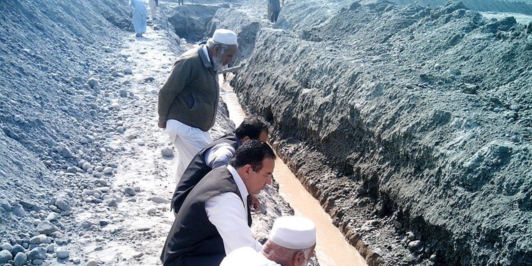
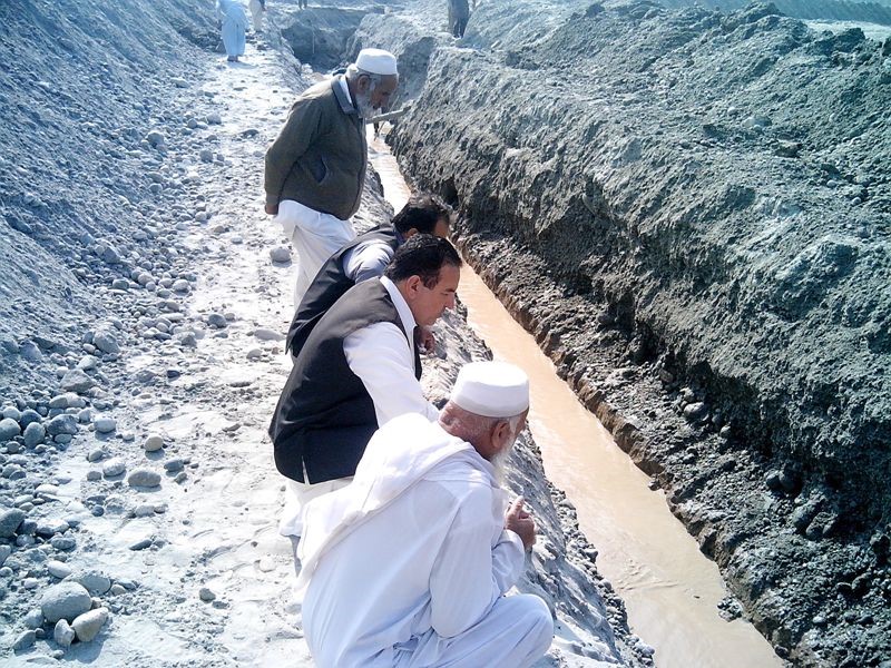
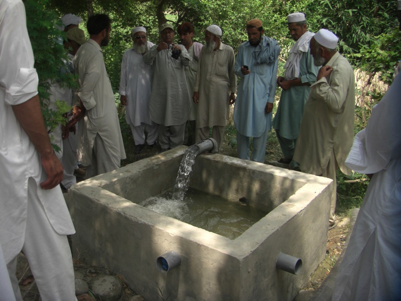
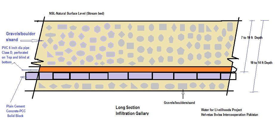
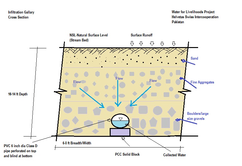
The purpose of this water harvesting technology is to capture, collect and distribute sub-surface water. First, an infiltration gallery is developed, which allows the percolation and collection of sub-surface water through perforated pipes at a depth of approximately 3-4.5 metres. Sub-surface water is filtered by gravel/sand underground and infiltrates into the gallery. The harvested water is used for household needs as well as for livestock and irrigation through gravity flow.
2.2 การอธิบายแบบละเอียดของเทคโนโลยี
คำอธิบาย:
This method is applied in areas with low rainfall, where soils have a sandy-gravelly texture and where the sub-surface water can not percolate deeply, but instead flows laterally in shallow sub-surface channels. The technology consists of the following main elements: filtration materials (sand / gravel), collection chambers, perforated pipes, conveyance lines made from solid blocks, and storage tanks. Construction includes the following main activities and inputs:
• Excavation of rectangular trenches with machinery or by hand
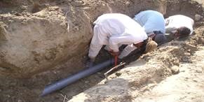
• Construction of a solid base line with PCC (plain cement concrete) blocks on the top of boulders
• Installation of perforated and blind pipes - and storage tanks where necessary
• Coverage of the trench first with boulders and then sand on top.
Once the gallery is constructed there is no further need for intervention; this means that maintenance costs for the user (farmer, households of the local community) are minimal. Traditionally, the technology has been implemented by local farmers for many years. Where improvements are required, support by local technicians is provided. The technology is based on local knowledge, and locally available construction materials. The method is technically simple, cost-effective and environmentally friendly. Farmers and other users consider this technology as very efficient as there is no need for external energy supply, and it can be easily replicated. Furthermore, it requires a minimum of external construction material and the operation costs are minimal. The captured water is filtered through the subsurface layers and - as long as there is no specific external contamination - it is safe and can be used for various purposes as already noted. This extra water supply is particularly effective for irrigation, contributing to increased production and allowing diversification of crop production (potentially also of high value crops), thereby improving the livelihoods of remote rural communities. The primary impact of this technology is to reduce risks related to droughts or water scarcity as natural phenomena or consequences of climate change effects. Additionally infiltration of water into the galleries reduces surface erosion of fertile soil, hence it lessens soil degradation.
2.3 รูปภาพของเทคโนโลยี
อัลบั้มสื่อบันทึก
2.5 ประเทศภูมิภาค หรือสถานที่ตั้งที่เทคโนโลยีได้นำไปใช้และได้รับการครอบคลุมโดยการประเมินนี้
ประเทศ:
ปากีสถาน
ภูมิภาค/รัฐ/จังหวัด:
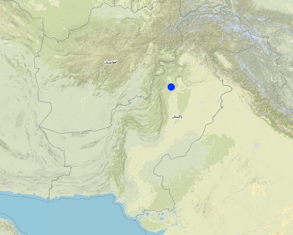
Southern Khyber Pakhtunkhwa
ข้อมูลจำเพาะเพิ่มเติมของสถานที่ตั้ง :
Karak, Laki Marwat & Dera Ismail Khan
ระบุการกระจายตัวของเทคโนโลยี:
- ใช้ ณ จุดที่เฉพาะเจาะจงหรือเน้นไปยังบริเวณพื้นที่ขนาดเล็ก
แสดงความคิดเห็น:
This technology is suitable for area with little slope to retain a maximum amount of water. when the stream bed has a higher gravel content, it provides more water. The technology is suitable for strata with no/ low vertical percolation, such as underlying hard rocks.
Map
×2.6 วันที่การดำเนินการ
ระบุปีที่ใช้:
2013
2.7 คำแนะนำของเทคโนโลยี
ให้ระบุว่าเทคโนโลยีถูกแนะนำเข้ามาอย่างไร:
- เป็นส่วนหนึ่งของระบบแบบดั้งเดิมที่ทำก้นอยู่ (> 50 ปี)
ความคิดเห็น (ประเภทของโครงการ เป็นต้น) :
Water for Livelihoods Project (rural development project)
3. การจัดประเภทของเทคโนโลยี SLM
3.1 วัตถุประสงค์หลักของเทคโนโลยี
- ปรับปรุงการผลิตให้ดีขึ้น
- ลด ป้องกัน ฟื้นฟู การเสื่อมโทรมของที่ดิน
- ป้องกันพื้นที่ลุ่มน้ำ/บริเวณท้ายน้ำ โดยร่วมกับเทคโนโลยีอื่นๆ
- ลดความเสี่ยงของภัยพิบัติ
- ปรับตัวเข้ากับการเปลี่ยนแปลงภูมิอากาศของโลก สภาพภูมิอากาศที่รุนแรงและผลกระทบ
- สร้างผลกระทบทางด้านเศรษฐกิจที่เป็นประโยชน์
- สร้างผลกระทบทางด้านสังคมที่เป็นประโยชน์
3.2 ประเภทของการใช้ที่ดินในปัจจุบันที่ได้นำเทคโนโลยีไปใช้

พื้นที่ปลูกพืช
- การปลูกพืชล้มลุกอายุปีเดียว
- การปลูกไม้ยืนต้น ไม้พุ่ม
Annual cropping - Specify crops:
- cereals - maize
- cereals - millet
- vegetables - other
- wheat, tomatoes
Tree and shrub cropping - Specify crops:
- mango, mangosteen, guava
จำนวนของฤดูเพาะปลูกต่อปี:
- 2
ระบุ:
Rabi (October to March) & Kharif (April to September) season
แสดงความคิดเห็น:
Main crops (cash and food crops):
- Wheat, maize/corn, millet
- Tomato and other vegetables
- Fruit trees: guava etc.
As a result of the introdued technology, farmers can now produce multiple crops and have increased the cropping efficiency.
3.3 Has land use changed due to the implementation of the Technology?
Has land use changed due to the implementation of the Technology?
- Yes (Please fill out the questions below with regard to the land use before implementation of the Technology)
พื้นที่ปลูกพืช
- การปลูกพืชล้มลุกอายุปีเดียว
แสดงความคิดเห็น:
Prior to the establishment of the infiltration gallery, cropland was mainly rain-fed and only a single crop was produced with 50 % cropping efficiency.
The cropping efficiency increased up to 150 % (growing 3 crops instead of 1 crop in a year).
3.4 การใช้น้ำ
การใช้น้ำของที่ดินที่มีการใช้เทคโนโลยีอยู่:
- จากน้ำฝน
แสดงความคิดเห็น:
- The technology is simple and not costly to establish.
- It further contributes to adapt to climate change, especially in areas where water becomes increasingly scarce.
3.5 กลุ่ม SLM ที่ตรงกับเทคโนโลยีนี้
- การเก็บเกี่ยวน้ำ
- การจัดการด้านชลประทาน (รวมถึงการลำเลียงส่งน้ำ การระบายน้ำ)
- การจัดการน้ำบาดาล
3.6 มาตรการ SLM ที่ประกอบกันเป็นเทคโนโลยี

มาตรการอนุรักษ์ด้วยโครงสร้าง
- S3: Graded ditches, channels, waterways
- S7: การกักเก็บน้ำ/การส่งลำเลียง/อุปกรณ์การชลประทาน
- S10: มาตรการในการประหยัดพลังงาน
3.7 รูปแบบหลักของการเสื่อมโทรมของที่ดินที่ได้รับการแก้ไขโดยเทคโนโลยี

การกัดกร่อนของดินโดยน้ำ
- Wt (Loss of topsoil): การสูญเสียดินชั้นบนหรือการกัดกร่อนที่ผิวดิน
3.8 การป้องกัน การลดลง หรือการฟื้นฟูความเสื่อมโทรมของที่ดิน
ระบุเป้าหมายของเทคโนโลยีกับความเสื่อมโทรมของที่ดิน:
- ลดความเสื่อมโทรมของดิน
- ปรับตัวกับสภาพความเสื่อมโทรมของที่ดิน
แสดงความคิดเห็น:
Further the technology contributes to reduce risks and losses linked to droughts as natural hazard and/or the effect of climate change.
4. ข้อมูลจำเพาะด้านเทคนิค กิจกรรมการนำไปปฏิบัติใช้ ปัจจัยนำเข้า และค่าใช้จ่าย
4.1 แบบแปลนทางเทคนิคของเทคโนโลยี
ข้อมูลจำเพาะด้านเทคนิค (แบบแปลนทางเทคนิคของเทคโนโลยี):
Dimensions of the cross section:
- Depth: 10 to 15 feet, width: 6 to 8 feet, length: 300 to 1000 feet
- Slope: 3% on 200 feet
- Volume of storage tank: 30 x 30 x 4 feet
ผู้เขียน:
Munawar Khan & Khan Muhammad
วันที่:
2013
ผู้เขียน:
Munawar Khan & Khan Muhammad
วันที่:
2013
4.2 ข้อมูลทั่วไปเกี่ยวกับการคำนวณปัจจัยนำเข้าและค่าใช้จ่าย
ให้ระบุว่าค่าใช้จ่ายและปัจจัยนำเข้าได้รับการคำนวณอย่างไร:
- ต่อหน่วยเทคโนโลยี
โปรดระบุหน่วย:
Infiltration gallery: conveyance, collection chamber and tank
Specify dimensions of unit (if relevant):
600 feet gallery (including 3600 feet conveyance lineconveyance line to the tank/water user's end point (adduction section without wholes for infiltration))
ระบุสกุลเงินที่ใช้คำนวณค่าใช้จ่าย:
- USD
ระบุค่าเฉลี่ยของค่าจ้างในการจ้างแรงงานต่อวัน:
Skilled labour: 12 USD/day, unskilled labour: 6 USD /day
4.3 กิจกรรมเพื่อการจัดตั้ง
| กิจกรรม | Timing (season) | |
|---|---|---|
| 1. | Excavation | 2 weeks |
| 2. | Dry stone packing | 1 week |
| 3. | Laying of PCC block (plain cement concrete) | 2-3 days |
| 4. | Installation & fixing of perforated pipes (6" diameter) | 2-3 days |
| 5. | Establishement of filtration media (boulder, gravel, sand packing)at gallery's end point/ water user's access point (if required) material: concrete | 2 weeks |
| 6. | Construction of water collecting chamber | 1 week |
| 7. | Convayance line (3" diameter) | 3 weeks |
| 8. | construction of storage tank (if required) | 4 weeks as parallel activity |
แสดงความคิดเห็น:
Totally, it takes 3 months to complete the construction of the infiltration gallery unit (600 feet) including the conveyance line and storage tank. Some of the activities can be carried out in parallel.
4.4 ค่าใช้จ่ายของปัจจัยนำเข้าที่จำเป็นสำหรับการจัดตั้ง
| ปัจจัยนำเข้า | หน่วย | ปริมาณ | ค่าใช้จ่ายต่อหน่วย | ค่าใช้จ่ายทั้งหมดต่อปัจจัยนำเข้า | %ของค่าใช้จ่ายที่ก่อให้เกิดขึ้นโดยผู้ใช้ที่ดิน | |
|---|---|---|---|---|---|---|
| แรงงาน | Skilled Labour | Days | 109.0 | 12.0 | 1308.0 | |
| แรงงาน | Un-Skilled Labour | Days | 465.0 | 6.0 | 2790.0 | 100.0 |
| อุปกรณ์ | Machinary (Excavator) | Hour | 118.0 | 25.0 | 2950.0 | |
| วัสดุสำหรับก่อสร้าง | Bricks (Number) | 1000 | 12.5 | 95.0 | 1187.5 | |
| วัสดุสำหรับก่อสร้าง | PCC blocks, rough stone (cubic foot) | 100 | 44.5 | 50.0 | 2225.0 | |
| วัสดุสำหรับก่อสร้าง | Cement (50 kg bags) | 50 | 275.0 | 5.0 | 1375.0 | |
| วัสดุสำหรับก่อสร้าง | sand, crush, boulder, gravel (cubic foot) | 100 | 63.0 | 35.0 | 2205.0 | |
| อื่น ๆ | PVC pipe perforated (6" diameter filter section class D) (ft) | 1 | 590.0 | 5.0 | 2950.0 | |
| อื่น ๆ | PVC blind pipe (3" diameter class B) (ft) | 1 | 3600.0 | 1.0 | 3600.0 | |
| ค่าใช้จ่ายทั้งหมดของการจัดตั้งเทคโนโลยี | 20590.5 | |||||
| Total costs for establishment of the Technology in USD | 20590.5 | |||||
ถ้าผู้ใช้ที่ดินรับภาระน้อยกว่า 100% ของค่าใช้จ่าย ให้ระบุว่าใครเป็นผู้รับผิดชอบส่วนที่เหลือ:
Project / Government partner - i.e. on Farm Water Management department & public Health engineering Department, shared the cost at the ratio of 80 % : 20 %.
แสดงความคิดเห็น:
Total cost of the technology is basically proportional to the length of gallery and futher dependson the size of the storage tank.
4.5 การบำรุงรักษาสภาพหรือกิจกรรมที่เกิดขึ้นเป็นประจำ
แสดงความคิดเห็น:
This technology is based on a single cost investment. Except minor repairs of storage tank, there are no relevant maintanance costs.
The filter function of the boulder layer and the perforated pipes reduce sedimentation problems. Minor amounts of silt and fine sediments in the storage tank can be removed with minor effort by the user (unskilled labo no tools required),
4.7 ปัจจัยสำคัญที่สุดที่มีผลกระทบต่อค่าใช้จ่าย
ปัจจัยสำคัญที่สุดที่มีผลกระทบต่อค่าใช้จ่ายต่างๆ:
- Length of the infiltration gallery
- Length of the conveyance line
- Size of storage tank (not alway included)
5. สิ่งแวดล้อมทางธรรมชาติและของมนุษย์
5.1 ภูมิอากาศ
ฝนประจำปี
- < 250 ม.ม.
- 251-500 ม.ม.
- 501-750 ม.ม.
- 751-1,000 ม.ม.
- 1,001-1,500 ม.ม.
- 1,501-2,000 ม.ม.
- 2,001-3,000 ม.ม.
- 3,001-4,000 ม.ม.
- > 4,000 ม.ม.
ระบุปริมาณน้ำฝนเฉลี่ยรายปี (ถ้ารู้) :หน่วย ม.ม.
300.00
ข้อมูลจำเพาะ/ความคิดเห็นเรื่องปริมาณน้ำฝน:
rains in both season (monsoon & winter)
ระบุชื่อของสถานีตรวดวัดอากาศที่ใช้อ้างอิงคือ:
Kohat & Bannu & DIKhan Met Department Automatic Weather Station
เขตภูมิอากาศเกษตร
- กึ่งแห้งแล้ง
Min. /max. temperatures: 9°C / 42°C
5.2 สภาพภูมิประเทศ
ค่าเฉลี่ยความลาดชัน:
- ราบเรียบ (0-2%)
- ลาดที่ไม่ชัน (3-5%)
- ปานกลาง (6-10%)
- เป็นลูกคลื่น (11-15%)
- เป็นเนิน (16-30%)
- ชัน (31-60%)
- ชันมาก (>60%)
ธรณีสัณฐาน:
- ที่ราบสูง/ที่ราบ
- สันเขา
- ไหล่เขา
- ไหล่เนินเขา
- ตีนเนิน
- หุบเขา
ระดับความสูง:
- 0-100 เมตร
- 101-500 เมตร
- 501-1,000 เมตร
- 1,001-1,500 เมตร
- 1,501-2,000 เมตร
- 2,001-2,500 เมตร
- 2,501-3,000 เมตร
- 3,001-4,000 เมตร
- > 4,000 เมตร
ให้ระบุถ้าเทคโนโลยีได้ถูกนำไปใช้:
- ไม่เกี่ยวข้อง
5.3 ดิน
ค่าเฉลี่ยความลึกของดิน:
- ตื้นมาก (0-20 ซ.ม.)
- ตื้น (21-50 ซ.ม.)
- ลึกปานกลาง (51-80 ซ.ม.)
- ลึก (81-120 ซ.ม.)
- ลึกมาก (>120 ซ.ม.)
เนื้อดิน (ดินชั้นบน):
- หยาบ/เบา (ดินทราย)
เนื้อดินล่าง (> 20 ซ.ม.ต่ำจากผิวดิน):
- หยาบ/เบา (ดินทราย)
อินทรียวัตถุในดิน:
- ปานกลาง (1-3%)
5.4 ความเป็นประโยชน์และคุณภาพของน้ำ
ระดับน้ำใต้ดิน:
5-50 เมตร
น้ำไหลบ่าที่ผิวดิน:
ปานกลาง
คุณภาพน้ำ (ที่ยังไม่ได้บำบัด):
เป็นน้ำเพื่อการดื่มที่ดี
ความเค็มของน้ำเป็นปัญหาหรือไม่:
ไม่ใช่
กำลังเกิดน้ำท่วมในพื้นที่หรือไม่:
ใช่
ความคิดเห็นและข้อมูลจำเพาะเพิ่มเติมเรื่องคุณภาพและปริมาณน้ำ:
Due to floods in monsoon season, the discharge capacity increases.
5.5 ความหลากหลายทางชีวภาพ
ความหลากหลายทางชนิดพันธุ์:
- ปานกลาง
ความหลากหลายของแหล่งที่อยู่:
- ต่ำ
5.6 ลักษณะของผู้ใช้ที่ดินที่นำเทคโนโลยีไปปฏิบัติใช้
อยู่กับที่หรือเร่ร่อน:
- อยู่กับที่
แนวทางการตลาดของระบบการผลิต:
- เพื่อการยังชีพ (หาเลี้ยงตนเอง)
- mixed (subsistence/ commercial)
รายได้ที่มาจากนอกฟาร์ม:
- > 50% ของรายได้ทั้งหมด
ระดับของความมั่งคั่งโดยเปรียบเทียบ:
- จน
เป็นรายบุคคล/ครัวเรือน:
- เป็นรายบุคคล/ครัวเรือน
- กลุ่ม/ชุมชน
ระดับของการใช้เครื่องจักรกล:
- งานที่ใช้แรงกาย
- การใช้กำลังจากสัตว์
เพศ:
- หญิง
- ชาย
อายุของผู้ใช้ที่ดิน:
- วัยกลางคน
5.7 Average area of land used by land users applying the Technology
- < 0.5 เฮกตาร์
- 0.5-1 เฮกตาร์
- 1-2 เฮกตาร์
- 2-5 เฮกตาร์
- 5-15 เฮกตาร์
- 15-50 เฮกตาร์
- 50-100 เฮกตาร์
- 100-500 เฮกตาร์
- 500-1,000 เฮกตาร์
- 1,000-10,000 เฮกตาร์
- >10,000 เฮกตาร์
พิจารณาว่าเป็นขนาดเล็ก กลาง หรือขนาดใหญ่ (ซึ่งอ้างอิงถึงบริบทระดับท้องถิ่น):
- ขนาดเล็ก
5.8 กรรมสิทธิ์ในที่ดิน สิทธิในการใช้ที่ดินและสิทธิในการใช้น้ำ
กรรมสิทธิ์ในที่ดิน:
- รายบุคคล ได้รับสิทธิครอบครอง
สิทธิในการใช้ที่ดิน:
- เกี่ยวกับชุมชน (ถูกจัดระเบียบ)
- รายบุคคล
สิทธิในการใช้น้ำ:
- เกี่ยวกับชุมชน (ถูกจัดระเบียบ)
- รายบุคคล
5.9 การเข้าถึงบริการและโครงสร้างพื้นฐาน
สุขภาพ:
- จน
- ปานกลาง
- ดี
การศึกษา:
- จน
- ปานกลาง
- ดี
ความช่วยเหลือทางด้านเทคนิค:
- จน
- ปานกลาง
- ดี
การจ้างงาน (เช่น ภายนอกฟาร์ม):
- จน
- ปานกลาง
- ดี
ตลาด:
- จน
- ปานกลาง
- ดี
พลังงาน:
- จน
- ปานกลาง
- ดี
ถนนและการขนส่ง:
- จน
- ปานกลาง
- ดี
น้ำดื่มและการสุขาภิบาล:
- จน
- ปานกลาง
- ดี
บริการด้านการเงิน:
- จน
- ปานกลาง
- ดี
6. ผลกระทบและสรุปคำบอกกล่าว
6.1 ผลกระทบในพื้นที่ดำเนินการ (On-site) จากการใช้เทคโนโลยี
ผลกระทบทางด้านเศรษฐกิจและสังคม
การผลิต
การผลิตพืชผล
แสดงความคิดเห็น/ระบุ:
increased crop production efficiency due to additional and year-round water avalability for irrigation.
คุณภาพพืชผล
แสดงความคิดเห็น/ระบุ:
with the additional water for irrigation, water is no limiting factor anymore, with allows an improved crop productin in terms of quality and quantity.
การผลิตพืชที่ใช้เลี้ยงปศุสัตว์
จำนวนก่อน SLM:
-1
หลังจาก SLM:
1
ความหลากหลายของผลิตภัณฑ์
จำนวนก่อน SLM:
-1
หลังจาก SLM:
2
แสดงความคิดเห็น/ระบุ:
with additional water through irrigation, additional crops might be cultivated, which contributes to production and income diversification.
พื้นที่สำหรับการผลิต
แสดงความคิดเห็น/ระบุ:
with additional water through irrigation, additional areas can be used for agriculture.
ความเป็นประโยชน์และคุณภาพของน้ำ
การมีน้ำดื่มไว้ให้ใช้
คุณภาพน้ำดื่ม
จำนวนก่อน SLM:
0
หลังจาก SLM:
2
การมีน้ำไว้ให้ปศุสัตว์
การมีน้ำไว้ให้สำหรับการชลประทาน
จำนวนก่อน SLM:
-2
หลังจาก SLM:
3
คุณภาพน้ำสำหรับการชลประทาน
จำนวนก่อน SLM:
0
หลังจาก SLM:
3
ความต้องการน้ำจากการชลประทาน
แสดงความคิดเห็น/ระบุ:
the technology directly contributes to additional water for irrigation
รายได้และค่าใช้จ่าย
รายได้จากฟาร์ม
แสดงความคิดเห็น/ระบุ:
Irrigation allows improved, diversified crop production. Water access for lifestock ensures animals health. Both crucial aspects for the income of local farmers
ความหลากหลายของแหล่งผลิตรายได้
จำนวนก่อน SLM:
0
หลังจาก SLM:
1
ผลกระทบด้านสังคมวัฒนธรรมอื่น ๆ
ความมั่นคงด้านอาหาร / พึ่งตนเองได้
จำนวนก่อน SLM:
-1
หลังจาก SLM:
2
การใช้ที่ดิน / สิทธิในการใช้น้ำ
จำนวนก่อน SLM:
0
หลังจาก SLM:
2
ผลกระทบด้านนิเวศวิทยา
วัฐจักรน้ำหรือน้ำบ่า
การเก็บเกี่ยวหรือการกักเก็บน้ำ
จำนวนก่อน SLM:
0
หลังจาก SLM:
2
ความหลากหลายทางชีวภาพของพืชและสัตว์
การปกคลุมด้วยพืช
จำนวนก่อน SLM:
0
หลังจาก SLM:
1
ลดความเสี่ยงของภัยพิบัติ
ผลกระทบจากภัยแล้ง
แสดงความคิดเห็น/ระบุ:
reduced consequences of droughts/water scarcity, in terms of production failure/lost harvest and reduced production
6.2 ผลกระทบนอกพื้นที่ดำเนินการ (Off-site) จากการใช้เทคโนโลยี
น้ำที่ใช้ประโยชน์ได้
การไหลของน้ำคงที่และสม่ำเสมอในช่วงฤดูแล้ง
6.3 การเผชิญและความตอบสนองของเทคโนโลยีต่อการเปลี่ยนแปลงสภาพภูมิอากาศที่ค่อยเป็นค่อยไป และสภาพรุนแรงของภูมิอากาศ / ภัยพิบัติ (ที่รับรู้ได้โดยผู้ใช้ที่ดิน)
การเปลี่ยนแปลงสภาพภูมิอากาศที่ค่อยเป็นค่อยไป
การเปลี่ยนแปลงสภาพภูมิอากาศที่ค่อยเป็นค่อยไป
| ฤดู | increase or decrease | เทคโนโลยีมีวิธีการรับมืออย่างไร | |
|---|---|---|---|
| ฝนประจำปี | เพิ่มขึ้น | ดี | |
| ฝนตามฤดู | ฤดูร้อน | เพิ่มขึ้น | ดี |
สภาพรุนแรงของภูมิอากาศ (ภัยพิบัติ)
ภัยพิบัติจากสภาพภูมิอากาศ
| เทคโนโลยีมีวิธีการรับมืออย่างไร | |
|---|---|
| ภัยจากฝนแล้ง | ดี |
6.4 การวิเคราะห์ค่าใช้จ่ายและผลประโยชน์ที่ได้รับ
ผลประโยชน์ที่ได้รับเปรียบเทียบกับค่าใช้จ่ายในการจัดตั้งเป็นอย่างไร (จากมุมมองของผู้ใช้ที่ดิน)
ผลตอบแทนระยะสั้น:
ด้านบวก
ผลตอบแทนระยะยาว:
ด้านบวกอย่างมาก
ผลประโยชน์ที่ได้รับเปรียบเทียบกับค่าใช้จ่ายในการบำรุงรักษาหรือต้นทุนที่เกิดขึ้นซ้ำอีก เป็นอย่างไร (จากมุมมองของผู้ใช้ที่ดิน)
ผลตอบแทนระยะสั้น:
ด้านบวก
ผลตอบแทนระยะยาว:
ด้านบวก
6.5 การปรับตัวของเทคโนโลยี
- 1-10%
Of all those who have adopted the Technology, how many did so spontaneously, i.e. without receiving any material incentives/ payments?
- 11-50%
6.6 การปรับตัว
เทคโนโลยีได้รับการปรับเปลี่ยนเมื่อเร็วๆนี้ เพื่อให้ปรับตัวเข้ากับสภาพที่กำลังเปลี่ยนแปลงหรือไม่:
ใช่
ถ้าตอบว่าใช่ ให้ระบุว่าเงื่อนไขการเปลี่ยนแปลงใดที่ถูกปรับตัว:
- การเปลี่ยนแปลงแบบค่อยเป็นค่อยไปและสภาพรุนแรงของภูมิอากาศ
ให้ระบุการปรับตัวของเทคโนโลยี (การออกแบบ วัสดุหรือชนิดพันธุ์ เป็นต้น):
Design of infiltration galleries (diameter of pipes, size of perforation, slope etc.) was adjusted to local conditions including the consideration of local rainfall / amount of water.
6.7 จุดแข็ง / ข้อได้เปรียบ / โอกาสของเทคโนโลยี
| จุดแข็ง / ข้อได้เปรียบ / โอกาสในทัศนคติของผู้ใช้ที่ดิน |
|---|
| Low cost measure, which requires only a one-time investment, low/no repair or maintenance costs are required. |
| Well assimilated and replicated by local farmers of the area since it is a simple and traditional technology. |
| No requirement of external energy (no pumping). |
| Allows harvest of sub-surface water for different purposes (domestic use, irrigation, livestock). |
| Environmentally friendly, making use as much as possible of local construction material (gravel, sand). |
| จุดแข็ง / ข้อได้เปรียบ / โอกาสในทัศนคติของผู้รวบรวมหรือวิทยากรหลัก |
|---|
| The technology can be replicated in areas of similar conditions, as well as up-scaled with little efforts in other areas with a similar environment. |
6.8 จุดอ่อน / ข้อเสียเปรียบ / ความเสี่ยงของเทคโนโลยีและวิธีการแก้ไข
| จุดอ่อน / ข้อเสียเปรียบ / ความเสี่ยงในทัศนคติของผู้ใช้ที่ดิน | มีวิธีการแก้ไขได้อย่างไร |
|---|---|
| If the land, where the sub-surface water is harvested is communal property, the distribution of water rights may be an issue. | Involvement of farmer organizations, distribution of water rights based on land holdings have to according check water rights. |
| จุดอ่อน / ข้อเสียเปรียบ / ความเสี่ยงในทัศนคติของผู้รวบรวมหรือวิทยากรหลัก | มีวิธีการแก้ไขได้อย่างไร |
|---|---|
| Filtration media might clogge in the long run in case silt content is high. | Filtration media should be prepared with graded materials (sand, gravel, boulder). |
| Considering the initial investment cost, the measure cannot be done by an individual alone. | It requires an organized (group of) community. Though this pre-condition can also be interpreted as a strength for a coordinated and efficient use of water. |
7. การอ้างอิงและการเชื่อมต่อ
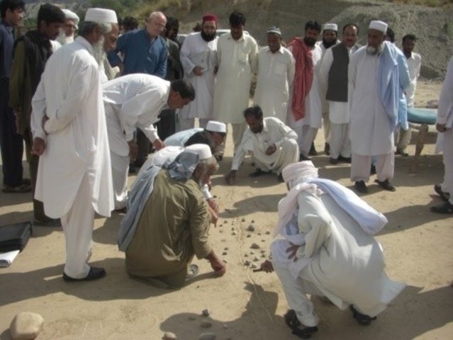
7.1 วิธีการและแหล่งข้อมูล
- ไปเยี่ยมชมภาคสนาม การสำรวจพื้นที่ภาคสนาม
5-10
- การสัมภาษณ์กับผู้ใช้ที่ดิน
20-30
- การสัมภาษณ์ผู้เชี่ยวชาญด้าน SLM หรือผู้ชำนาญ
2-3
วันที่เก็บรวบรวมข้อมูล(ภาคสนาม) :
31/12/2015
ลิงก์และโมดูล
ขยายทั้งหมด ย่อทั้งหมดลิงก์
Water Use Management Plan (WUMP) [ปากีสถาน]
The overall purpose of WUMP is to compile an inventory of available water ressources in a particular geographical or administrative area, to identify communities' priorities in order to achieve an effective, equitable and efficient use of water resources at local level. This approach promotes a participatory and inclusive analysis and …
- ผู้รวบรวม: Eveline Studer
โมดูล
ไม่มีโมดูล