Tiarako dyke [Burkina Faso]
- Creation:
- Update:
- Compiler: Moussa ABOU
- Editors: Siagbé Golli, Brice Sosthène BAYALA, Tabitha Nekesa, Ahmadou Gaye
- Reviewers: Sally Bunning, Rima Mekdaschi Studer, William Critchley
Tiarako Ka Kabakourou Walandéni (Dioula)
technologies_6687 - Burkina Faso
View sections
Expand all Collapse all1. General information
1.2 Contact details of resource persons and institutions involved in the assessment and documentation of the Technology
Key resource person(s)
land user:
MILLOGO Joseph
Burkina Faso
land user:
MILLOGO Herman
Burkina Faso
land user:
TRAORE Ouranza
Burkina Faso
Name of project which facilitated the documentation/ evaluation of the Technology (if relevant)
Soil protection and rehabilitation for food security (ProSo(i)l)Name of the institution(s) which facilitated the documentation/ evaluation of the Technology (if relevant)
Deutsche Gesellschaft für Internationale Zusammenarbeit (GIZ)1.3 Conditions regarding the use of data documented through WOCAT
The compiler and key resource person(s) accept the conditions regarding the use of data documented through WOCAT:
Yes
1.4 Declaration on sustainability of the described Technology
Is the Technology described here problematic with regard to land degradation, so that it cannot be declared a sustainable land management technology?
No
2. Description of the SLM Technology
2.1 Short description of the Technology
Definition of the Technology:
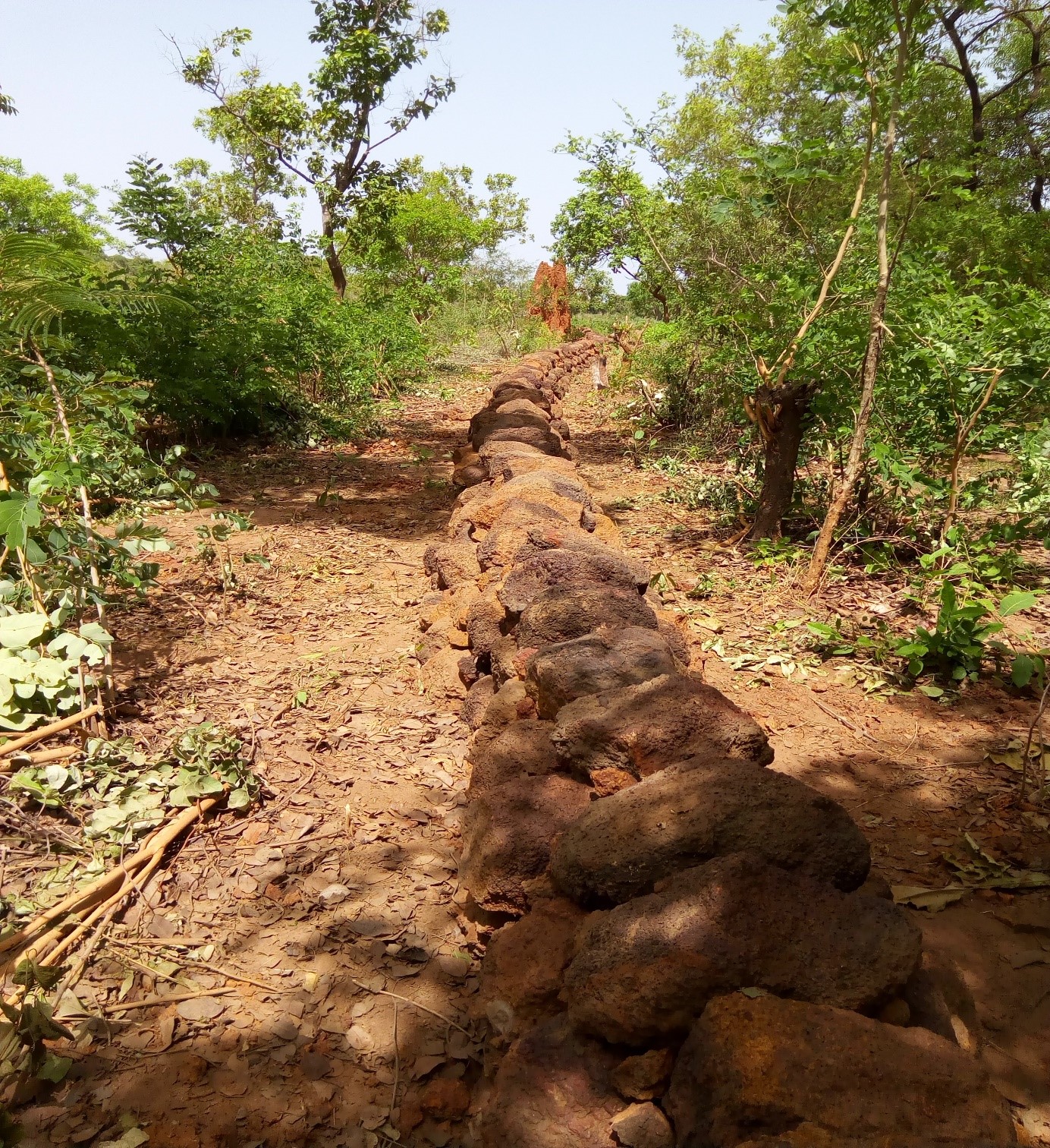
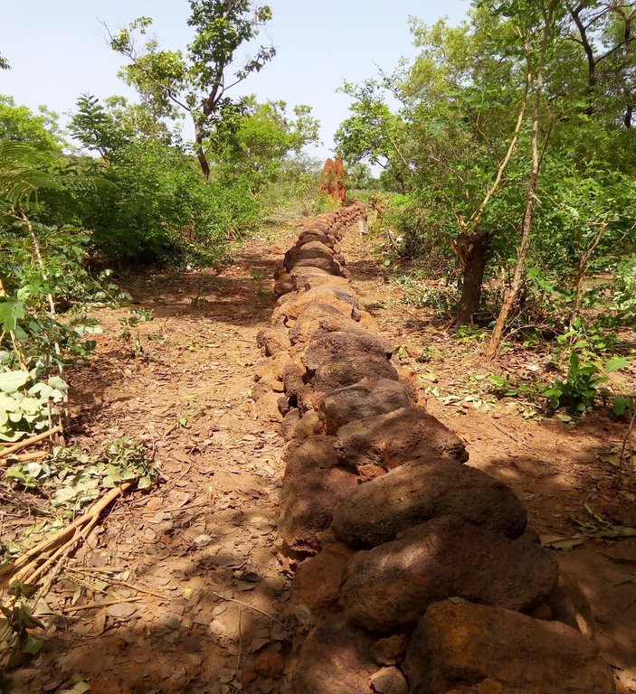
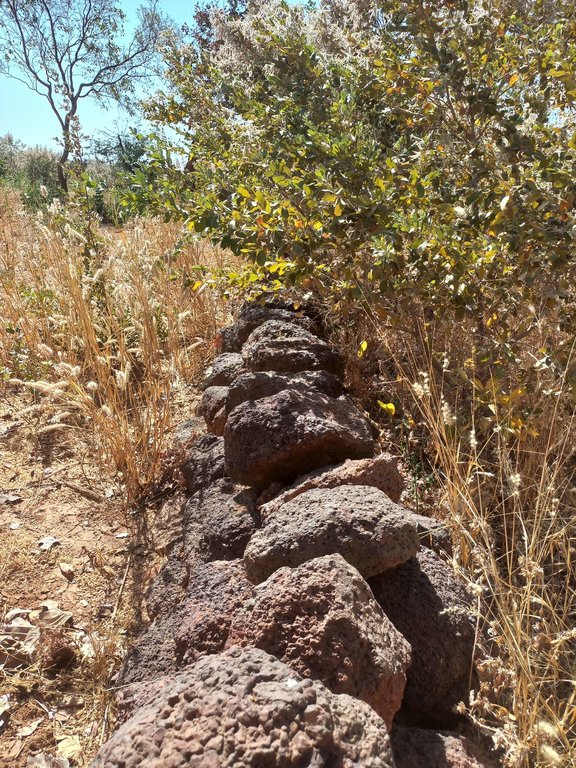
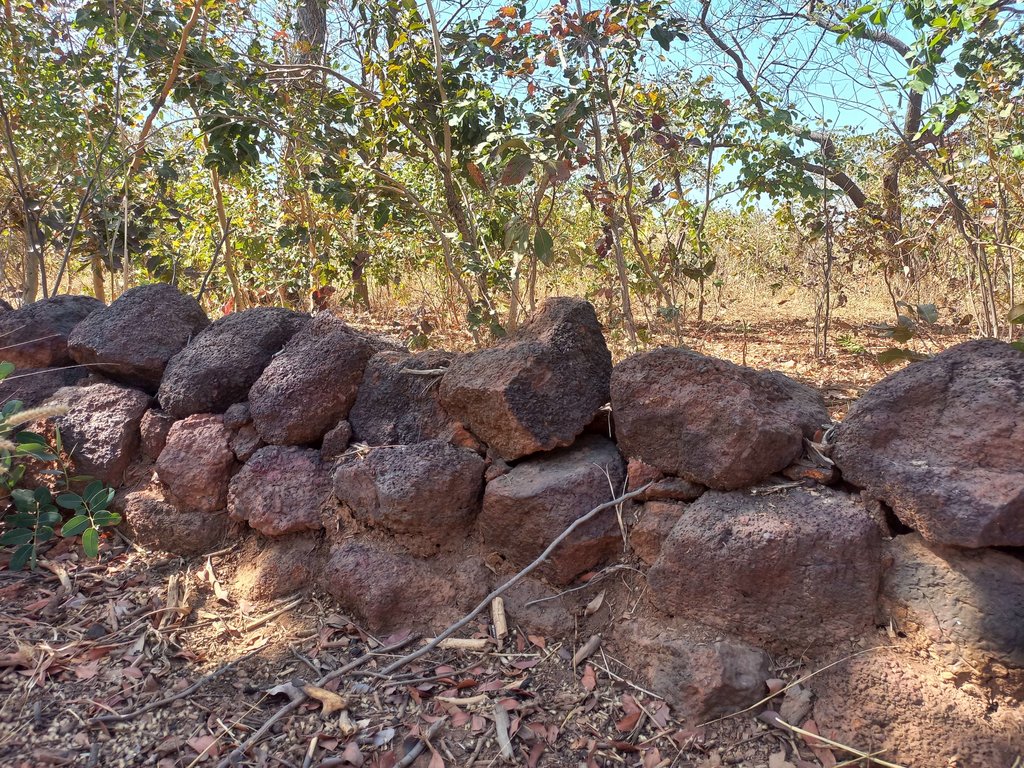
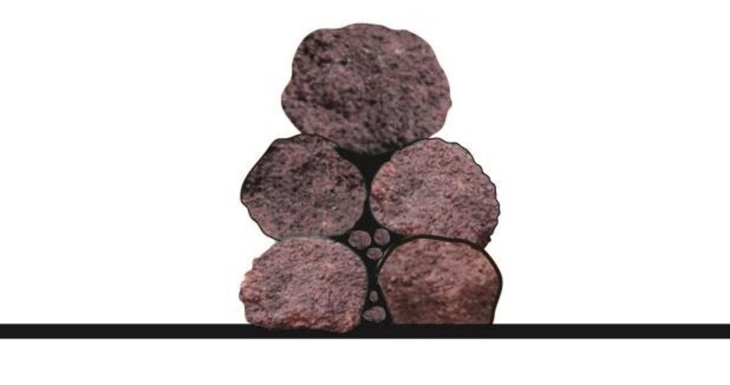
The Tiarako dyke is an erosion control structure composed of stones organized in three rows of five lines along contour lines. The dykes are filtering structures designed to diminish the impact of runoff water, enabling excess water to pass through. This design aims to prevent water concentration upstream and slow down water flow downstream.
2.2 Detailed description of the Technology
Description:
The technology is applicable to all agro-sylvo-pastoral production land in the North Sudan and Sahelian zones, but it is agricultural land (cultivated fields or degraded land in the process of being converted to cultivation) and their watersheds that are most often developed. The Tiarako dyke consists of an assembly of medium-sized loose stones with a horizontal crest approximately 50 cm high and 50 cm wide. It serves to mitigate water runoff from slopes and protect other structures. Alternatively, it can be placed along runoff lines as intermediate structures, effectively controlling stronger flows.
The Tiarako bund is built in five stages:
1) Identifying the major slope:
With a simple observation of the land with the naked eye the farmer can determine which way the water flows fastest during the rainy season; this is the major slope. This observation can be improved by using a watertube level or an A-Frame.
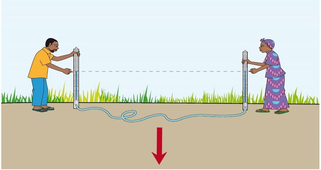
2) Determining the contour lines using a watertube level :
•position oneself at one end upstream of the site to be surveyed, perpendicular to the slope;
•Position support 1 at the end of the projected bund. Support 2 is adjusted iteratively until the water level aligns with the reference point of Support 1, marking the crossing of the contour line.
•Once this point is determined, mark a line on the ground connecting the bases of the two supports, or replace the supports with stakes.
•Secure Support 2 in place and adjust Support 1 in the desired direction. Repeat the iterative process to locate the marker, then trace as previously instructed. Continue this process until reaching the end of the treatment area
3) Smoothing
This involves delineating the contour lines while smoothening the curve's contours. This method allows for the construction of a structure while minimizing the amount of stone needed, as the structure's length is reduced
4) Excavation of a foundation:
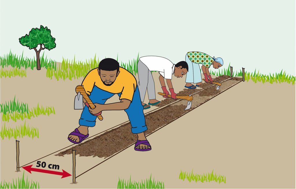
•Place 2 stakes side by side on the curve, 50 cm apart to form the width of the stone barrier;
•Delineate the working area based on rope availability; then place 2 other stakes opposite the first 2;
•Measure out 50 cm on the stakes and make a notch for marking;
•Tie a rope at the notch of one stake and pull the rope along the working area to wind it up at the notch of the opposite stake;
•Do the same for the other 2 posts;
•Open an anchoring furrow 10 to 15 cm deep and 50 cm wide on the line marked out, taking care to dispose of the stripped earth upslope of the curve.
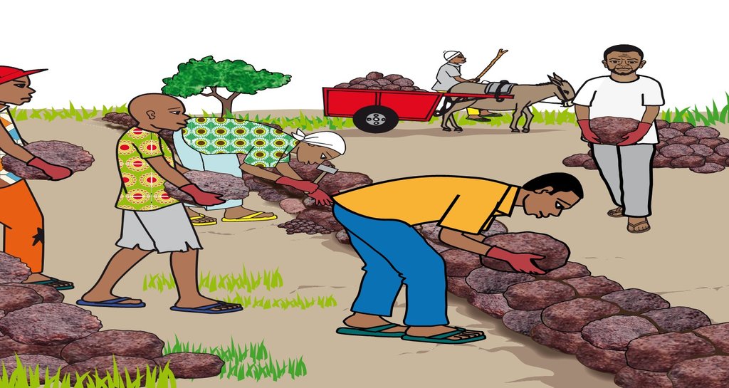
5) Laying the rubble stones:
•Place two lines of medium-sized stones side by side in the trench, so that they rest on their largest face;
•Seal the interstices;
•Superimpose two other lines of medium-sized stones on the first two lines, then a fifth line, ensuring that the ridge is horizontal;
•Space out the contours, taking into account the slope of the land - the steeper the slope, the closer together the contours and structures.
The main inputs required to implement this technology are loose stones and tools (water level, pickaxe, shovel, cart, wheelbarrow, etc.).
Efficient for reclaiming gullied soils, this technology helps increase water infiltration upstream, and sedimentation of sand, clay and organic debris, ensuring terrain reshaping.
It helps farmers mitigate water erosion. However, farmers believe that without assistance from development partners, implementing this technology is nearly unfeasible due to its labour-intensive demands.
2.3 Photos of the Technology
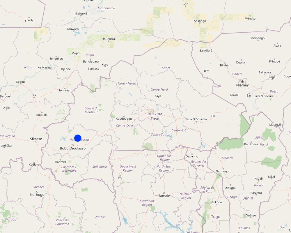
2.5 Country/ region/ locations where the Technology has been applied and which are covered by this assessment
Country:
Burkina Faso
Region/ State/ Province:
Hauts-Bassins, Houet Province
Further specification of location:
Tiarako (Commune of Satiri)
Specify the spread of the Technology:
- applied at specific points/ concentrated on a small area
Is/are the technology site(s) located in a permanently protected area?
No
Comments:
The technology is applied on the scale of the watershed.
Map
×2.6 Date of implementation
Indicate year of implementation:
2019
2.7 Introduction of the Technology
Specify how the Technology was introduced:
- through projects/ external interventions
Comments (type of project, etc.):
The Tiarako dykes were designed and tested by ProSoil for the first time in the Tiarako sub-watershed in the commune of Satiri in 2019.
3. Classification of the SLM Technology
3.1 Main purpose(s) of the Technology
- reduce, prevent, restore land degradation
- protect a watershed/ downstream areas – in combination with other Technologies
- preserve/ improve biodiversity
- create beneficial economic impact
3.2 Current land use type(s) where the Technology is applied
Land use mixed within the same land unit:
Yes
Specify mixed land use (crops/ grazing/ trees):
- Agroforestry

Cropland
- Annual cropping
- Tree and shrub cropping
Annual cropping - Specify crops:
- cereals - maize
- cereals - sorghum
Tree and shrub cropping - Specify crops:
- karite (sheanut)
Number of growing seasons per year:
- 1
Is intercropping practiced?
Yes
If yes, specify which crops are intercropped:
Sorghum and cowpea
Is crop rotation practiced?
Yes
If yes, specify:
Maize and sorghum
3.3 Has land use changed due to the implementation of the Technology?
Has land use changed due to the implementation of the Technology?
- Yes (Please fill out the questions below with regard to the land use before implementation of the Technology)
Land use mixed within the same land unit:
No

Cropland
- Annual cropping

Unproductive land
Specify:
Unproductive lands have become productive thanks to this technology.
Comments:
Lands that were once unproductive have become productive thanks to reduced runoff velocities and sediment deposition on lands located downstream of the bunds.
3.4 Water supply
Water supply for the land on which the Technology is applied:
- rainfed
3.5 SLM group to which the Technology belongs
- cross-slope measure
3.6 SLM measures comprising the Technology

structural measures
- S2: Bunds, banks
3.7 Main types of land degradation addressed by the Technology

soil erosion by water
- Wt: loss of topsoil/ surface erosion
- Wg: gully erosion/ gullying

soil erosion by wind
- Et: loss of topsoil
- Ed: deflation and deposition
- Eo: offsite degradation effects
3.8 Prevention, reduction, or restoration of land degradation
Specify the goal of the Technology with regard to land degradation:
- reduce land degradation
4. Technical specifications, implementation activities, inputs, and costs
4.1 Technical drawing of the Technology
Technical specifications (related to technical drawing):
Cross-section of the Tiarako embankment (5 stones)
Crest height: 50 cm;
Width: 50 cm;
Anchoring furrow 10 to 15 cm deep and 50 cm wide;
Rubble stones
Author:
ProSoil/GIZ
Date:
2020
Technical specifications (related to technical drawing):
Foundation excavation
Furrow depth of 10 to 15 cm, with a 50 cm width
Author:
ProSoil/GIZ
Date:
2020
Technical specifications (related to technical drawing):
Placement of rubble stones for the construction of the Tiarako bund:
•Arrange in the trench two (02) adjacent rows of medium-sized stones so that they rest on their largest face;
•Fill the gaps;
•Layer two (02) additional rows of medium-sized stones over the first two (02) rows, then a fifth row ensuring the horizontal alignment of the crest;
•Space accordingly considering the slope of the terrain.
Author:
ProSoil/GIZ
Date:
2020
Technical specifications (related to technical drawing):
Determining contour lines with a water level:
The major slope is identified when the water level rises highest on the graduated support tube (marker pole) located at the bottom, compared to the water level in the marker pole positioned at the top.
The calculation of the slope is performed as follows:
L is the distance between the two graduated marker poles of the water level (m),
H is the variation in water level (cm) when positioned at the lowest point of the slope,
P is the average slope (%) and is the sum of variations from the starting point to the lower limit of the surface to be treated: P = (H ÷ L) x 100
For example, if H = 1.5m and L = 125m; P = (1.5 / 125) x 100 P= 0.012 x 100 = 1.2%.
Slopes between 1-2% are considered very low. The spacing between stone lines is 40 m: agricultural work and crops following the contour lines on the soil and simple cordons made of vegetation and/or stones help to capture and slow down runoff water;
Slopes between 2-3% are considered low. The spacing between stone lines is 30 m;
Slopes between 3-5% are considered moderate. The spacing between stone lines is 20 m;
Slopes between 5-10% are considered high. The spacing between stone lines is 15 m;
Slopes between 10-15% are considered very high. The spacing between stone lines is 13 m;
(Source): WSC/SDR/IN.E.R.A Data Sheet
Note:
The water level consists of a flexible tube filled with water, with each end of the tube attached to a graduated stick – marker pole.
Author:
ProSoil/GIZ
Date:
2020
4.2 General information regarding the calculation of inputs and costs
Specify how costs and inputs were calculated:
- per Technology unit
Specify unit:
Linear meter
If relevant, indicate exchange rate from USD to local currency (e.g. 1 USD = 79.9 Brazilian Real): 1 USD =:
613.5
Indicate average wage cost of hired labour per day:
CFA F 106/linear meter
4.3 Establishment activities
| Activity | Timing (season) | |
|---|---|---|
| 1. | Determination of major slopes and contours | February |
| 2. | Smoothing | April to May |
| 3. | Excavation of a foundation | April to May |
| 4. | Installation of the rubble stones | April to May |
4.4 Costs and inputs needed for establishment
| Specify input | Unit | Quantity | Costs per Unit | Total costs per input | % of costs borne by land users | |
|---|---|---|---|---|---|---|
| Labour | Determination of major slopes and contours | Linear meter | 1.0 | 6.0 | 6.0 | |
| Labour | Opening of trenches and construction | Linear meter | 1.0 | 100.0 | 100.0 | |
| Equipment | Cost of small equipment | Linear meter | 1.0 | 15.0 | 15.0 | |
| Construction material | Purchase of rubble stones | Linear meter | 1.0 | 1250.0 | 1250.0 | |
| Other | Monitoring costs | Linear meter | 1.0 | 10.0 | 10.0 | |
| Other | Coordination costs | Linear meter | 1.0 | 5.0 | 5.0 | |
| Total costs for establishment of the Technology | 1386.0 | |||||
| Total costs for establishment of the Technology in USD | 2.26 | |||||
If land user bore less than 100% of costs, indicate who covered the remaining costs:
The installations were financed by ProSol.
4.5 Maintenance/ recurrent activities
| Activity | Timing/ frequency | |
|---|---|---|
| 1. | Maintenance and repair of the bund | At the beginning of the crop season. |
Comments:
It has been shown that stone falls are caused by field owners during ploughing, children hunting for game, runoff water and moving animals. It is therefore important to raise people's awareness about the importance of ploughing parallel to the contour line, isolating structures by 0.5 m on either side, and organizing maintenance and repair work at the start of each campaign.
4.6 Costs and inputs needed for maintenance/ recurrent activities (per year)
| Specify input | Unit | Quantity | Costs per Unit | Total costs per input | % of costs borne by land users | |
|---|---|---|---|---|---|---|
| Other | Maintenance and repair of the bund | Linear meter | 1.0 | 10.0 | 10.0 | 100.0 |
| Total costs for maintenance of the Technology | 10.0 | |||||
| Total costs for maintenance of the Technology in USD | 0.02 | |||||
Comments:
The plan is to organize maintenance and repair work at the start of each campaign.
4.7 Most important factors affecting the costs
Describe the most determinate factors affecting the costs:
The most significant factors affecting costs are the proximity of loose stones and the availability of labour.
5. Natural and human environment
5.1 Climate
Annual rainfall
- < 250 mm
- 251-500 mm
- 501-750 mm
- 751-1,000 mm
- 1,001-1,500 mm
- 1,501-2,000 mm
- 2,001-3,000 mm
- 3,001-4,000 mm
- > 4,000 mm
Specify average annual rainfall (if known), in mm:
900.00
Specifications/ comments on rainfall:
The Hauts Bassins region, where the village of Tiarako (Saitiri commune) is located, experiences a North Sudanese and South Sudanese tropical climate. This climate is characterized by two (02) main seasons: a wet season lasting 06 to 07 months (May to October/November) and a dry season lasting 05 to 06 months (November/December to April). Annual rainfall is relatively abundant, ranging from 800 to 1,200 mm.
Indicate the name of the reference meteorological station considered:
Satiri Rainfall Station
Agro-climatic zone
- sub-humid
Average temperatures vary between 24°c and 30°c, with a relatively small temperature range of 5°c.
5.2 Topography
Slopes on average:
- flat (0-2%)
- gentle (3-5%)
- moderate (6-10%)
- rolling (11-15%)
- hilly (16-30%)
- steep (31-60%)
- very steep (>60%)
Landforms:
- plateau/plains
- ridges
- mountain slopes
- hill slopes
- footslopes
- valley floors
Altitudinal zone:
- 0-100 m a.s.l.
- 101-500 m a.s.l.
- 501-1,000 m a.s.l.
- 1,001-1,500 m a.s.l.
- 1,501-2,000 m a.s.l.
- 2,001-2,500 m a.s.l.
- 2,501-3,000 m a.s.l.
- 3,001-4,000 m a.s.l.
- > 4,000 m a.s.l.
Indicate if the Technology is specifically applied in:
- convex situations
Comments and further specifications on topography:
The site under consideration is located at an altitude of 365 m.
5.3 Soils
Soil depth on average:
- very shallow (0-20 cm)
- shallow (21-50 cm)
- moderately deep (51-80 cm)
- deep (81-120 cm)
- very deep (> 120 cm)
Soil texture (topsoil):
- coarse/ light (sandy)
- fine/ heavy (clay)
Soil texture (> 20 cm below surface):
- coarse/ light (sandy)
- fine/ heavy (clay)
Topsoil organic matter:
- medium (1-3%)
If available, attach full soil description or specify the available information, e.g. soil type, soil PH/ acidity, Cation Exchange Capacity, nitrogen, salinity etc.
The soils in the area are predominantly tropical ferruginous soils with minimal or no leaching, and mostly deep hydromorphic (waterlogged) soils. The sandy-clay nature of these soils makes them sensitive to water erosion.
5.4 Water availability and quality
Ground water table:
5-50 m
Availability of surface water:
medium
Water quality (untreated):
poor drinking water (treatment required)
Water quality refers to:
both ground and surface water
Is water salinity a problem?
No
Is flooding of the area occurring?
No
5.5 Biodiversity
Species diversity:
- medium
Habitat diversity:
- medium
5.6 Characteristics of land users applying the Technology
Sedentary or nomadic:
- Sedentary
Market orientation of production system:
- mixed (subsistence/ commercial)
Off-farm income:
- less than 10% of all income
Relative level of wealth:
- average
Individuals or groups:
- groups/ community
Level of mechanization:
- animal traction
Gender:
- men
Age of land users:
- middle-aged
5.7 Average area of land used by land users applying the Technology
- < 0.5 ha
- 0.5-1 ha
- 1-2 ha
- 2-5 ha
- 5-15 ha
- 15-50 ha
- 50-100 ha
- 100-500 ha
- 500-1,000 ha
- 1,000-10,000 ha
- > 10,000 ha
Is this considered small-, medium- or large-scale (referring to local context)?
- medium-scale
5.8 Land ownership, land use rights, and water use rights
Land ownership:
- individual, not titled
Land use rights:
- open access (unorganized)
Water use rights:
- open access (unorganized)
- communal (organized)
Are land use rights based on a traditional legal system?
Yes
Specify:
Due to the sacred nature of the land, custom dictates that its management must not be subject to speculation.
Comments:
Based on information gathered from both literature and interviews, land access in the village of Tiarako is mainly through inheritance and borrowing. Other modes of access (lending, leasing and buying) do not appear to be common practice, nor a perceptible reality.
5.9 Access to services and infrastructure
health:
- poor
- moderate
- good
education:
- poor
- moderate
- good
technical assistance:
- poor
- moderate
- good
employment (e.g. off-farm):
- poor
- moderate
- good
markets:
- poor
- moderate
- good
energy:
- poor
- moderate
- good
roads and transport:
- poor
- moderate
- good
drinking water and sanitation:
- poor
- moderate
- good
financial services:
- poor
- moderate
- good
6. Impacts and concluding statements
6.1 On-site impacts the Technology has shown
Socio-economic impacts
Production
crop production
Quantity before SLM:
15 to 20 bags
Quantity after SLM:
30 to 40 bags
Comments/ specify:
Farmers report that before the Tiarako bund was installed, they were producing 15 to 20 bags of maize. Since the adoption of this technology, their production level has varied between 30 and 40 bags per hectare. This performance was achieved after three years of operating the site, through the use of improved seeds, organic fertilizer and the observance of technical production procedures.
crop quality
Income and costs
expenses on agricultural inputs
farm income
Socio-cultural impacts
food security/ self-sufficiency
health situation
recreational opportunities
SLM/ land degradation knowledge
Ecological impacts
Water cycle/ runoff
surface runoff
groundwater table/ aquifer
Soil
soil moisture
soil cover
soil loss
soil organic matter/ below ground C
Climate and disaster risk reduction
flood impacts
drought impacts
Specify assessment of on-site impacts (measurements):
The evaluation showed that the technology helps curb water erosion, runoff, chemical and organic degradation, while mitigating the effects of drought. Considering all these advantages, it is necessary to continue promoting this technology by popularizing the technology.
6.2 Off-site impacts the Technology has shown
water availability
downstream flooding
Comments/ specify:
Farmers mainly grow maize and sorghum, which are often combined with cowpeas. These crops are not particularly demanding in terms of water, which leads farmers to argue that a reduction in flooding is desirable.
damage on neighbours' fields
damage on public/ private infrastructure
Specify assessment of off-site impacts (measurements):
The technology is applied on a micro-catchment scale, which means that its impact is beneficial for producers located both upstream and downstream of the micro-catchment. With this in mind, its extension to other micro-watersheds should be considered.
6.3 Exposure and sensitivity of the Technology to gradual climate change and climate-related extremes/ disasters (as perceived by land users)
Gradual climate change
Gradual climate change
| Season | increase or decrease | How does the Technology cope with it? | |
|---|---|---|---|
| seasonal temperature | dry season | increase | not known |
6.4 Cost-benefit analysis
How do the benefits compare with the establishment costs (from land users’ perspective)?
Short-term returns:
slightly positive
Long-term returns:
positive
How do the benefits compare with the maintenance/ recurrent costs (from land users' perspective)?
Short-term returns:
very positive
Long-term returns:
very positive
Comments:
The technology does not require maintenance. It only requires monitoring.
6.5 Adoption of the Technology
- single cases/ experimental
Of all those who have adopted the Technology, how many did so spontaneously, i.e. without receiving any material incentives/ payments?
- 0-10%
Comments:
The difficulties involved in establishing the stone dykes and the amount of manpower needed to implement this technology make it difficult to adopt without the support of development partners.
6.6 Adaptation
Has the Technology been modified recently to adapt to changing conditions?
No
6.7 Strengths/ advantages/ opportunities of the Technology
| Strengths/ advantages/ opportunities in the land user’s view |
|---|
| Fights against water erosion and runoff |
| Increases inflltration of surface water into the soil. |
| Mitigates the effects of drought. |
| Strengths/ advantages/ opportunities in the compiler’s or other key resource person’s view |
|---|
| Reduces runoff and wind erosion. |
| Promotes water infiltration into the soil and upstream sedimentation of transported floating materials (straw, faeces, various organic matter). |
| Recovers degraded soil. |
6.8 Weaknesses/ disadvantages/ risks of the Technology and ways of overcoming them
| Weaknesses/ disadvantages/ risks in the land user’s view | How can they be overcome? |
|---|---|
| Difficulties in transporting stone | Continue supporting farmers |
| Weaknesses/ disadvantages/ risks in the compiler’s or other key resource person’s view | How can they be overcome? |
|---|---|
| The implementation of this technology requires considerable financial and human resources. | Since these technologies are implemented on a micro-basin scale, it is necessary to keep organizing and supporting farmers. |
7. References and links
7.1 Methods/ sources of information
- field visits, field surveys
3
- interviews with land users
3
- interviews with SLM specialists/ experts
2
- compilation from reports and other existing documentation
7
When were the data compiled (in the field)?
01/19/2023
7.2 References to available publications
Title, author, year, ISBN:
Recueil des pratiques agro-écologiques éprouvées et mises en œuvre au Burkina Faso, Centre National de la Recherche Scientifique et Technologique, 2020/Compendium of proven agro-ecological practices implemented in Burkina Faso, National Scientific and Technological Research Center, 2020
Available from where? Costs?
Available on the Internet
Title, author, year, ISBN:
Catalogue de fiches techniques des mesures d’amélioration de la fertilité des sols, Projet « Réhabilitation et protection des sols dégradés et renforcement des instances foncières locales dans les zones rurales du Burkina Faso » (ProSol), 2020/A catalog of data sheets on soil fertility improvement measures, under the project entitled "Rehabilitation and protection of degraded soils and strengthening of local land tenure bodies in the rural areas of Burkina Faso" (ProSol), 2020
Available from where? Costs?
Available at ProSol-Burkina Faso
Title, author, year, ISBN:
Catalogue des mesures CES/DRS promues par le ProSol, 2020/A catalog of WSC/SDR measures promoted by ProSol, 2020
Available from where? Costs?
Available at ProSol-Burkina Faso
Title, author, year, ISBN:
Diagnostic sur les sites d’extension de quatre (04) micros bassins versants au profit du ProSol, Projet « Réhabilitation et protection des sols dégradés et renforcement des instances foncières locales dans les zones rurales du Burkina Faso » (ProSol), 2020/A diagnostic assessment of the extension sites of four (04) micro-catchment areas for the ProSol project, "Rehabilitation and protection of degraded soils and strengthening of local land tenure bodies in the rural areas of Burkina Faso" (ProSol), 2020
Available from where? Costs?
Available at ProSol-Burkina Faso
Title, author, year, ISBN:
Étude sur l’analyse coûts-bénéfices et économiques des mesures CES/DRS promues par ProSol, Projet « Réhabilitation et protection des sols dégradés et renforcement des instances foncières locales dans les zones rurales du Burkina Faso » (ProSol), 2020/A study on the cost-benefit and economic analysis of the WSC/SDR measures promoted by ProSol, under the project entitled "Rehabilitation and protection of degraded soils and strengthening of local land tenure bodies in the rural areas of Burkina Faso" (ProSol), 2020
Available from where? Costs?
Available at ProSol-Burkina Faso
Title, author, year, ISBN:
Réalisation d’un diagnostic de l’état des ressources naturelles et de la gestion foncière dans les régions du Sud-Ouest et des Hauts-Bassins au Burkina Faso, Projet « Réhabilitation et protection des sols dégradés et renforcement des instances foncières locales dans les zones rurales du Burkina Faso » (ProSol), 2015/A diagnostic study of the state of natural resources and land tenure management in the South-West and Hauts-Bassins regions of Burkina Faso, under the project entitled "Rehabilitation and protection of degraded soils and strengthening of local land tenure bodies in the rural areas of Burkina Faso" (ProSol), 2015
Available from where? Costs?
Available at ProSol-Burkina Faso
Title, author, year, ISBN:
Catalogue de bonnes pratiques d’adaptation aux risques climatiques au Burkina Faso, UICN/ Ministère de l’Environnement et du Développement Durable, 2011/A catalog of good climate risk adaptation practices in Burkina Faso, IUCN/Ministry of the Environment and Sustainable Development, 2011
Available from where? Costs?
Available on the Internet
Links and modules
Expand all Collapse allLinks
No links
Modules
No modules


