Water Spreading Weirs [Ethiopia]
- Creation:
- Update:
- Compiler: GERBA LETA
- Editors: Torben Helbig, Noel Templer, Tabitha Nekesa, Ahmadou Gaye, Siagbé Golli
- Reviewers: William Critchley, Rima Mekdaschi Studer, Sally Bunning
Biye Baahiwe
technologies_6715 - Ethiopia
View sections
Expand all Collapse all1. General information
1.2 Contact details of resource persons and institutions involved in the assessment and documentation of the Technology
Key resource person(s)
SLM specialist:
Mohamed Badal
Natural Resource Development Protection and Utilization Department of Somali Region Bureau of Agriculture.
Ethiopia
Name of project which facilitated the documentation/ evaluation of the Technology (if relevant)
Soil protection and rehabilitation for food security (ProSo(i)l)Name of the institution(s) which facilitated the documentation/ evaluation of the Technology (if relevant)
CIAT International Center for Tropical Agriculture (CIAT International Center for Tropical Agriculture) - Kenya1.3 Conditions regarding the use of data documented through WOCAT
The compiler and key resource person(s) accept the conditions regarding the use of data documented through WOCAT:
Yes
1.4 Declaration on sustainability of the described Technology
Is the Technology described here problematic with regard to land degradation, so that it cannot be declared a sustainable land management technology?
No
Comments:
It is soil and water conservation and degraded land rehabilitation technology. Furthermore, the water harvested can be used for spate irrigation and growing food crops and livestock feed.
1.5 Reference to Questionnaire(s) on SLM Approaches (documented using WOCAT)
Participatory Rehabilitation of Dry Valleys [Ethiopia]
Participatory rehabilitation and productive use of dry valleys is an approach employed to rehabilitate degraded and degradable land. It is operationalised through the Lowland Soil Rehabilitation Project with local development partners from kebele, district, regional agricultural bureaus, and other relevant stakeholders.
- Compiler: GERBA LETA
2. Description of the SLM Technology
2.1 Short description of the Technology
Definition of the Technology:
Water Spreading Weirs are designed to protect the degradation of agricultural fields and rangelands. They contribute to soil and water conservation and enhance the productive use of dry valleys for food crops and livestock fodder production via the harvest and spread of runoff water and fertile soils.
2.2 Detailed description of the Technology
Description:
Water Spreading Weirs (WSWs) spread runoff water to the tips of the structure's wings, slowing down the speed of runoff and arresting the sediment pouring downstream. WSWs are applicable both on farmland and rangelands to improve the productive use of the land’s resources. They protect soil erosion and control gully development as well as increasing surface and sub-surface water availability. Activities such as mobilization of the community through awareness creation are among the numerous tasks implemented to put the technology in place. The community participates in site selection and participatory planning. Other stakeholders assist in area delineation, profiling the implementation area, and design. Labour and inputs such as surveying and construction materials, notably stone, sand, water, and cement, and equipment such as line levels, theodolites, spades, hoes, forks, string and measuring tapes etc. are required. On top of these, implementing the technology is supported by satellite images and ground validation exercises.
The main purpose of the technology is to reduce land degradation, harvest and use runoff water for spate irrigation and household uses, improve environmental resilience to the risks of drought, increase the depth and fertility of land behind the structure by capturing sediment washed away, allow infiltration of water and increase overall production of food and fodder crops. Also, the contribution to groundwater recharge is immense. Furthermore, it allows the agropastoral community to grow both cash and food crops which helps to ensure food security. Above all, the water harvested means people can remain in the area and that their livestock have access to drinking water for about three months after interception of rainfall. However, the agropastoralists may be discouraged by the size of the WSWs which can be from one hundred to over two hundred meters across. Care also must be taken that the structures do not cross livestock migration routes.
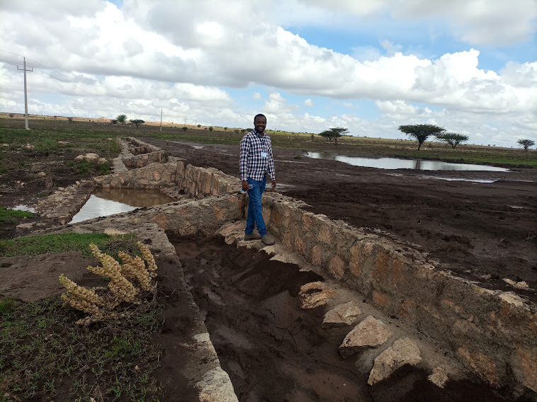
2.3 Photos of the Technology
Media Gallery
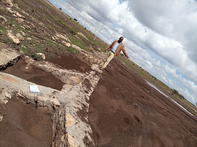
General remarks regarding photos:
The photo is trying to portray the water and soil harvested/stopped from running downstream. The detachment and removal of the topsoil without cover and fragile soil types are easily removed and transported to a long distance beyond the regional territory. The trends denied the productive use of land resources. In contradiction, the structure mitigates the loss of water and soil.
2.4 Videos of the Technology
Comments, short description:
Video for this technology was not captured.
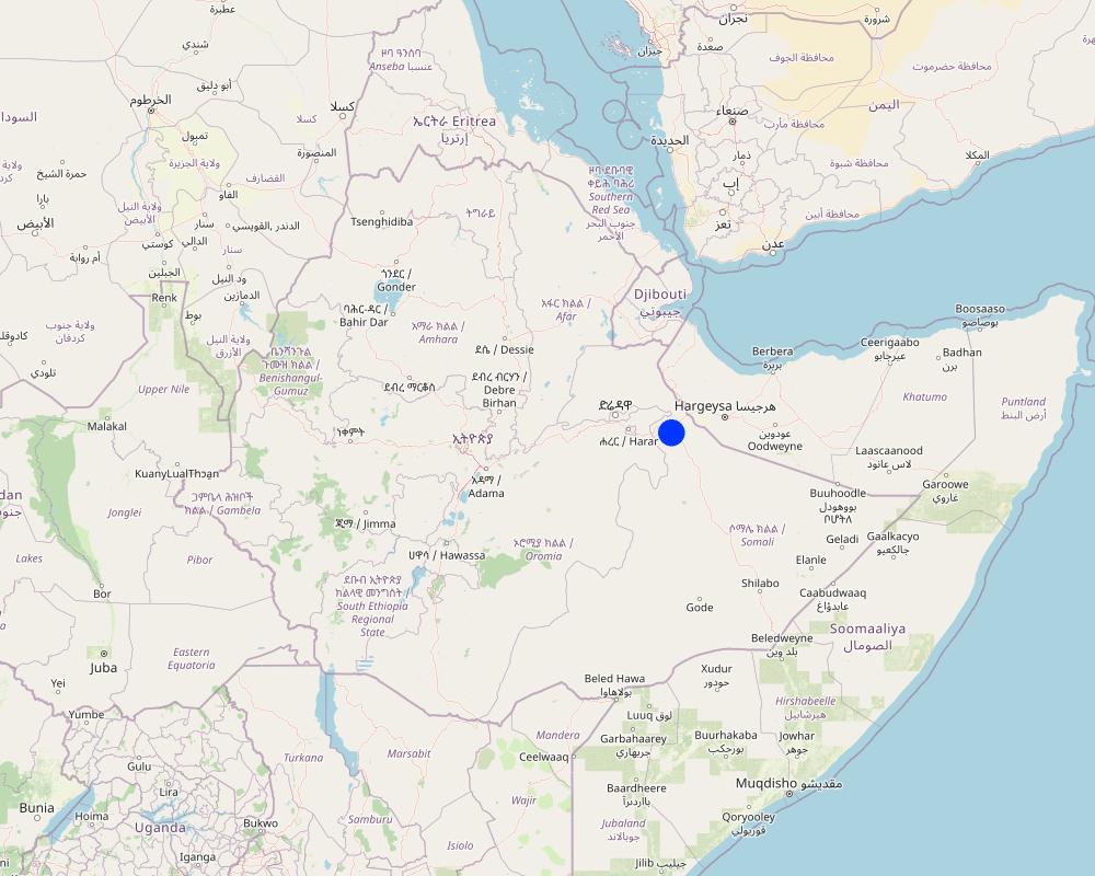
2.5 Country/ region/ locations where the Technology has been applied and which are covered by this assessment
Country:
Ethiopia
Region/ State/ Province:
Somali
Further specification of location:
Amadle kebele, South Jijiga district
Specify the spread of the Technology:
- applied at specific points/ concentrated on a small area
Is/are the technology site(s) located in a permanently protected area?
No
Comments:
It is located on the farmland used by the extended family and beyond.
Map
×2.6 Date of implementation
Indicate year of implementation:
2022
If precise year is not known, indicate approximate date:
- less than 10 years ago (recently)
2.7 Introduction of the Technology
Specify how the Technology was introduced:
- through projects/ external interventions
Comments (type of project, etc.):
The technology was put in place in partnership with the government bureau of agriculture and line office with the Capacity Development and Strengthening Drought Resilience (CDSDR) Project of the GIZ in the Somali Region.
3. Classification of the SLM Technology
3.1 Main purpose(s) of the Technology
- improve production
- reduce, prevent, restore land degradation
- protect a watershed/ downstream areas – in combination with other Technologies
- reduce risk of disasters
- create beneficial economic impact
3.2 Current land use type(s) where the Technology is applied
Land use mixed within the same land unit:
Yes
Specify mixed land use (crops/ grazing/ trees):
- Agro-pastoralism (incl. integrated crop-livestock)

Cropland
- Annual cropping
- Perennial (non-woody) cropping
Annual cropping - Specify crops:
- cereals - maize
- cereals - sorghum
- vegetables - other
- legumes and pulses - soya
Number of growing seasons per year:
- 1
Specify:
The legume crop is chickpea. Whereas, the vegetables are tomato and onion.
Is intercropping practiced?
Yes
If yes, specify which crops are intercropped:
Maize is intercropped with chickpeas.
Is crop rotation practiced?
Yes
If yes, specify:
Cereal crop sorghum rotates with maize and chickpeas. Essentially, crop production suffers from a lack of adequate rainfall. For example, during the last two to three years the area experienced drought. Mainly livestock supports the livelihoods of the inhabitants.

Grazing land
- Agro-pastoralist
Animal type:
- goats
- cattle - dairy and beef (e.g. zebu)
- camels
- sheep
Is integrated crop-livestock management practiced?
Yes
If yes, specify:
Essentially, the farming operation is practiced by oxen-plow in which case the animals provide traction force whereas crop residue supply feed to the animals.
Products and services:
- milk
- manure as fertilizer/ energy production
- transport/ draught
- meat
Comments:
Agro-pastoralism is the common practices in Amadle kebele of south Jijiga district.
3.3 Has land use changed due to the implementation of the Technology?
Has land use changed due to the implementation of the Technology?
- No (Continue with question 3.4)
3.4 Water supply
Water supply for the land on which the Technology is applied:
- rainfed
Comments:
The rainfall distribution is erratic with violent erosive feature flooding the plain with severe damage when flowing downstream.
3.5 SLM group to which the Technology belongs
- integrated crop-livestock management
- cross-slope measure
- irrigation management (incl. water supply, drainage)
3.6 SLM measures comprising the Technology

structural measures
- S6: Walls, barriers, palisades, fences
Comments:
The technology is Water Spreading Weirs, stop the run-off and distribute the water across the farmland.
3.7 Main types of land degradation addressed by the Technology

soil erosion by water
- Wt: loss of topsoil/ surface erosion
- Wg: gully erosion/ gullying
- Wm: mass movements/ landslides

soil erosion by wind
- Et: loss of topsoil
- Ed: deflation and deposition
- Eo: offsite degradation effects

physical soil deterioration
- Pi: soil sealing

water degradation
- Ha: aridification
- Hs: change in quantity of surface water
- Hg: change in groundwater/aquifer level
- Hp: decline of surface water quality
- Hq: decline of groundwater quality
Comments:
The technology/structure contributes strongly to soil and water management. The tremendous loss of both resources is immensely reduced by the application of water spreading weirs.
3.8 Prevention, reduction, or restoration of land degradation
Specify the goal of the Technology with regard to land degradation:
- reduce land degradation
- restore/ rehabilitate severely degraded land
Comments:
The technology reduces the speed of runoff, stores the sediments, and distributes the water across the structure which creates an opportunity for spate irrigation and the use of residual moisture as supplemental sources of irrigation for growing early maturing crops.
4. Technical specifications, implementation activities, inputs, and costs
4.1 Technical drawing of the Technology
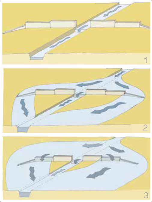
Technical specifications (related to technical drawing):
Spate schemes depending on the increase supply flow:
Part i: The flow of small flood rested channel in the river bed
Part ii: A small or medium flood and overflows pours on the lower wings, &
Part iii: A large flood also pours on high wings.
Author:
Anonymous consultant
4.2 General information regarding the calculation of inputs and costs
Specify how costs and inputs were calculated:
- per Technology unit
Specify unit:
1 WSW
Specify dimensions of unit (if relevant):
Variable ( could be from 100m to over 200m depending on the steepness and width of the farmland.
Specify currency used for cost calculations:
- USD
Indicate average wage cost of hired labour per day:
8.414 USD
4.3 Establishment activities
| Activity | Timing (season) | |
|---|---|---|
| 1. | Assessing the field (observation) | |
| 2. | Consult the local community along with agricultural partners at different levels | |
| 3. | Surveying and profile data collection | |
| 4. | Develop design and get approval | |
| 5. | Outsource the engineering/masonry works | |
| 6. | Train the masonry workers | |
| 7. | Supply materials | |
| 8. | Implement (execute the excavation and the masonry work) | |
| 9. | Monitor the development (construction supervision) |
Comments:
Note: 1 USD = 53.481 Ethiopian birr (ETB) when this data is collected.
4.4 Costs and inputs needed for establishment
If you are unable to break down the costs in the table above, give an estimation of the total costs of establishing the Technology:
27490.0
If land user bore less than 100% of costs, indicate who covered the remaining costs:
So far, the project entirely cover the investment and maintenance costs.
Comments:
According to the project and regional bureau of agriculture experts, a single structure costs 27, 490 USD. However, in one cascade (dry valley treatment unit) about 8-10 structures are necessary to successfully address the objective of the technology (Soil and Water Management) and ensure productive use of the land from soil arrest and residue of moisture captured in the area. It also enables the use of runoff for spate irrigation.
4.5 Maintenance/ recurrent activities
| Activity | Timing/ frequency | |
|---|---|---|
| 1. | Assess and identify the damage | During the off-season for ease of access to the sites |
| 2. | Estimate the level and cost of damage | During the off-season |
| 3. | Supply materials | |
| 4. | Employ the masonry worker | |
| 5. | Construct /maintain the damaged parts | Before the short/long rainy season. |
Comments:
Maintenance costs are largely associated with the degree of damage and cost of materials and masonry worker or labor costs that consistently changing in current Ethiopia.
4.6 Costs and inputs needed for maintenance/ recurrent activities (per year)
If you are unable to break down the costs in the table above, give an estimation of the total costs of maintaining the Technology:
12154.0
If land user bore less than 100% of costs, indicate who covered the remaining costs:
The cost is borne by the project.
Comments:
The technical experts give only an estimate of both initial investment and maintenance costs. Variations in materials and labor costs are frequent beyond the imagination. However, maintenance depends on the degree of damage. It seems that maintenance cost estimation takes the highest sides which may dishearten the adoption of the technology in the absence of projects.
4.7 Most important factors affecting the costs
Describe the most determinate factors affecting the costs:
Economic crisis and frequently escalating material costs along with rising financial inflation.
5. Natural and human environment
5.1 Climate
Annual rainfall
- < 250 mm
- 251-500 mm
- 501-750 mm
- 751-1,000 mm
- 1,001-1,500 mm
- 1,501-2,000 mm
- 2,001-3,000 mm
- 3,001-4,000 mm
- > 4,000 mm
Specify average annual rainfall (if known), in mm:
750.00
Specifications/ comments on rainfall:
Rainfall is erratic and erosive. The project site receives rainfall twice a year (Belg- short rain from March to April and Meher- long rain from June to September). However, the number of days on which rain is intercepted is fewer than the ranges stated over here.
Indicate the name of the reference meteorological station considered:
Jijiga Meteorology station
Agro-climatic zone
- semi-arid
South Jigjiga district is characterized by hot weather.
5.2 Topography
Slopes on average:
- flat (0-2%)
- gentle (3-5%)
- moderate (6-10%)
- rolling (11-15%)
- hilly (16-30%)
- steep (31-60%)
- very steep (>60%)
Landforms:
- plateau/plains
- ridges
- mountain slopes
- hill slopes
- footslopes
- valley floors
Altitudinal zone:
- 0-100 m a.s.l.
- 101-500 m a.s.l.
- 501-1,000 m a.s.l.
- 1,001-1,500 m a.s.l.
- 1,501-2,000 m a.s.l.
- 2,001-2,500 m a.s.l.
- 2,501-3,000 m a.s.l.
- 3,001-4,000 m a.s.l.
- > 4,000 m a.s.l.
Indicate if the Technology is specifically applied in:
- concave situations
Comments and further specifications on topography:
The topography where WSW technology/structures are put in place is mostly on gentle slopes across the dry valley drainage line.
5.3 Soils
Soil depth on average:
- very shallow (0-20 cm)
- shallow (21-50 cm)
- moderately deep (51-80 cm)
- deep (81-120 cm)
- very deep (> 120 cm)
Soil texture (topsoil):
- medium (loamy, silty)
Soil texture (> 20 cm below surface):
- medium (loamy, silty)
Topsoil organic matter:
- low (<1%)
If available, attach full soil description or specify the available information, e.g. soil type, soil PH/ acidity, Cation Exchange Capacity, nitrogen, salinity etc.
The soil ranges from black silty loam to brown silty and fragile soils that are highly vulnerable to flood. It easily detached and moved away with runoff.
5.4 Water availability and quality
Ground water table:
> 50 m
Availability of surface water:
poor/ none
Water quality (untreated):
poor drinking water (treatment required)
Water quality refers to:
ground water
Is water salinity a problem?
Yes
Specify:
As the weather of the area is often too hot salinity is not uncommon in the aquifer.
Is flooding of the area occurring?
Yes
Regularity:
episodically
Comments and further specifications on water quality and quantity:
Rainfall is characterized by erratic and erosive nature. Therefore, flooding is common when heavy rain is intercepted.
5.5 Biodiversity
Species diversity:
- low
Habitat diversity:
- low
Comments and further specifications on biodiversity:
Less biodiversity of plant species. Acacias are the common trees, and opuntia and euphorbia species are also common plants in the area. A wild species that may be considered invasive is common in the area. The lower growing weed (wild species) locally known as Weylowed is suggested introduced from Yemen to the Somali part with onion.
5.6 Characteristics of land users applying the Technology
Sedentary or nomadic:
- Semi-nomadic
Market orientation of production system:
- subsistence (self-supply)
Off-farm income:
- less than 10% of all income
Relative level of wealth:
- poor
Individuals or groups:
- individual/ household
Level of mechanization:
- manual work
- animal traction
Indicate other relevant characteristics of the land users:
It is the community who are benefiting from the technology. Furthermore, this respondent is a regional SLM specialist. Therefore, specific information on age and gender is not given here though the community was also consulted.
5.7 Average area of land used by land users applying the Technology
- < 0.5 ha
- 0.5-1 ha
- 1-2 ha
- 2-5 ha
- 5-15 ha
- 15-50 ha
- 50-100 ha
- 100-500 ha
- 500-1,000 ha
- 1,000-10,000 ha
- > 10,000 ha
Is this considered small-, medium- or large-scale (referring to local context)?
- small-scale
Comments:
Extended family groups of four households are using the land where the WSW is put in place.
5.8 Land ownership, land use rights, and water use rights
Land ownership:
- communal/ village
- individual, not titled
Land use rights:
- communal (organized)
- individual
Water use rights:
- communal (organized)
- individual
Are land use rights based on a traditional legal system?
Yes
Specify:
Land use right is based on clan and extended family.
Comments:
The land is also owned by individuals. However, there is no land measurement and certification in this region.
5.9 Access to services and infrastructure
health:
- poor
- moderate
- good
education:
- poor
- moderate
- good
technical assistance:
- poor
- moderate
- good
employment (e.g. off-farm):
- poor
- moderate
- good
markets:
- poor
- moderate
- good
energy:
- poor
- moderate
- good
roads and transport:
- poor
- moderate
- good
drinking water and sanitation:
- poor
- moderate
- good
financial services:
- poor
- moderate
- good
6. Impacts and concluding statements
6.1 On-site impacts the Technology has shown
Socio-economic impacts
Production
crop production
Comments/ specify:
It is the expert's conviction that crop production in the area increased with water harvest and spread over the farm for use as spate or supplementary irrigation to the seasonal rainfall.
crop quality
Comments/ specify:
As the moisture harvested by the structure is believed to add grain filling period, the crop quality is also expected to increase.
fodder production
Comments/ specify:
Fodder production also increases with the availability of good soil and moisture conserved in the farm behind the structure.
fodder quality
animal production
Comments/ specify:
Increases with increasing availability of feed or fodder from either crop residue, natural grass or browse.
wood production
risk of production failure
Comments/ specify:
It rather improves crop resilience because of improved soil moisture.
product diversity
production area
Comments/ specify:
Opportunities can be created to increase the size of land under farming with increasing availability of moisture and fertile soils.
land management
Comments/ specify:
Moisture availability eases the management operation.
energy generation
Water availability and quality
drinking water availability
drinking water quality
Comments/ specify:
Basically, quality is not a priority issue for agro pastoralists in dry valley areas.
water availability for livestock
water quality for livestock
irrigation water availability
irrigation water quality
demand for irrigation water
Income and costs
expenses on agricultural inputs
Comments/ specify:
As the structure reduces the degree of degradation, expense on agricultural inputs is believed to be reduced.
farm income
diversity of income sources
workload
Socio-cultural impacts
food security/ self-sufficiency
health situation
land use/ water rights
cultural opportunities
recreational opportunities
community institutions
national institutions
SLM/ land degradation knowledge
Comments/ specify:
It promotes land users' understanding of SLM through training and exposure to the actual structure and soil and water harvested behind the structure.
conflict mitigation
situation of socially and economically disadvantaged groups
Comments/ specify:
They may manage to access water for livestock drink and/or household consumption.
Ecological impacts
Water cycle/ runoff
water quantity
water quality
harvesting/ collection of water
surface runoff
excess water drainage
groundwater table/ aquifer
evaporation
Soil
soil moisture
Comments/ specify:
The structure harvests soil moisture on the farm. It reduces the speed of runoff, stops, and spread over the farm.
soil cover
Comments/ specify:
Increased through production of more biomass.
soil loss
Comments/ specify:
The physical barriers stops the soil and water loss.
soil accumulation
soil crusting/ sealing
soil compaction
nutrient cycling/ recharge
salinity
Comments/ specify:
It is related to a warm climate that triggers evaporation and salinity development in the long run.
soil organic matter/ below ground C
acidity
Biodiversity: vegetation, animals
Vegetation cover
biomass/ above ground C
plant diversity
invasive alien species
animal diversity
beneficial species
habitat diversity
pest/ disease control
Climate and disaster risk reduction
flood impacts
landslides/ debris flows
drought impacts
impacts of cyclones, rain storms
emission of carbon and greenhouse gases
wind velocity
micro-climate
Specify assessment of on-site impacts (measurements):
As the intervention is in its early phase, it is difficult to give an assumption before and after the application of SLM (technology or physical structure). However, a 40 years old woman known as Run Muhamed gave us her insight into the productivity of the land by comparing the hindsight vs the current harvest under highly erratic and erosive rainfall distribution. Accordingly, over the years the harvest per hectare diminished from 0.75 ton/ha to 0.1 ton/ha. This signals the effect of climate change/climate variability and land degradation on crop production. Her household is one of the owners of the land among the other four members of the extended family where the WSW was put in place.
6.2 Off-site impacts the Technology has shown
water availability
Comments/ specify:
As the structure is recently constructed, it is dire to envisage the off-site impacts of the technology at this juncture. However, it has a positive contribution to the availability of groundwater in the adjacent farms.
reliable and stable stream flows in dry season
Comments/ specify:
Streams are less common in the dry valley.
downstream flooding
Comments/ specify:
It reduces the speed and volume of downstream flooding.
downstream siltation
groundwater/ river pollution
Comments/ specify:
Need an investigation of its impact on the groundwater.
buffering/ filtering capacity
wind transported sediments
damage on neighbours' fields
damage on public/ private infrastructure
impact of greenhouse gases
Comments/ specify:
Believed to reduce it in the long run.
Specify assessment of off-site impacts (measurements):
The intervention believed to improve the existing negative consequences of degradation through promoting soil and water management and reducing risks of crop failure.
6.3 Exposure and sensitivity of the Technology to gradual climate change and climate-related extremes/ disasters (as perceived by land users)
Gradual climate change
Gradual climate change
| Season | increase or decrease | How does the Technology cope with it? | |
|---|---|---|---|
| annual temperature | increase | moderately | |
| annual rainfall | decrease | well |
Climate-related extremes (disasters)
Meteorological disasters
| How does the Technology cope with it? | |
|---|---|
| local rainstorm | moderately |
| local sandstorm/ duststorm | not well |
Climatological disasters
| How does the Technology cope with it? | |
|---|---|
| drought | moderately |
Hydrological disasters
| How does the Technology cope with it? | |
|---|---|
| flash flood | moderately |
Comments:
After an extended dry year, like this season, the technology is overloaded with a flash flood. The soil was frequently exposed to the sun and the prevailing heat waves in the area were easily detached by torrential rain. Then the soil and water were partly arrested whereas an immense amount washed away. It seldom could topple the structure if not the cascade comprises eight to ten structures with relatively short intervals to support one another. Furthermore, the dry valley soil is very fragile let alone exposed to a long-term drought that is associated with a heavy shower at the beginning of a short season like this season.
6.4 Cost-benefit analysis
How do the benefits compare with the establishment costs (from land users’ perspective)?
Short-term returns:
positive
Long-term returns:
very positive
How do the benefits compare with the maintenance/ recurrent costs (from land users' perspective)?
Short-term returns:
positive
Long-term returns:
very positive
6.5 Adoption of the Technology
- single cases/ experimental
Comments:
It is a technology implemented at the community or extended family level. It is too early to evaluate the adoption trend at this particular time.
6.6 Adaptation
Has the Technology been modified recently to adapt to changing conditions?
No
6.7 Strengths/ advantages/ opportunities of the Technology
| Strengths/ advantages/ opportunities in the land user’s view |
|---|
| The technology/structure reduce soil and water erosion. |
| Harvest water and make the people and livestock beneficiaries from the still water for crop production, drinking, and household uses. |
| Increase soil moisture and risks of crop failure because of shortage of rainfall. |
| Strengths/ advantages/ opportunities in the compiler’s or other key resource person’s view |
|---|
| Rehabilitate both degraded agricultural and grazing lands. |
| Improve agropastoralist access to livestock feed and benefit from the positive impact caused by the technology. |
| Eventually, contributes to the improvement of ecology and overall ecosystem functioning. |
6.8 Weaknesses/ disadvantages/ risks of the Technology and ways of overcoming them
| Weaknesses/ disadvantages/ risks in the land user’s view | How can they be overcome? |
|---|---|
| High initial investment cost. | Enhance the in-kind contribution of the land users, and increase matching funds from the government as cost-sharing with other projects. |
| Agropastoralist complains about the space it occupies in their farmland regardless of the benefit they accrue over a long period. | Increase the awareness of the community on the productive uses of the degrading land based on the evidence. |
| The structure may fall over the livestock migration/travel routes that are not acknowledged by some members of the community. | During masonry work, precaution is essential to calm down the possible complaints that could emerge because of the raised structure by leveling the crossover roads/paths. |
| Weaknesses/ disadvantages/ risks in the compiler’s or other key resource person’s view | How can they be overcome? |
|---|---|
| An inadequate number of structures in a cascade subjected to ineffective soil and water management and distribution of rainwater to support as supplementary sources of moisture for crop production. | Increase the number of structures per conceptual statement and standardize the intervals between the structures. |
| Excessive land users' desire that is unassociated with a tangible contribution to the development of the technology from their side. | Further building land users understanding of SLM technologies and their benefits so that they can build a sense of ownership and accountability to contribute and complement the external efforts. |
| Land users give emphasis mainly on the immediate benefits of the technology (harvesting water for livestock drinking and household use) than the objectives of rehabilitating the dry valley for productive use of it such as crop and livestock feed production. | Acknowledging the immediate benefits, and the mainstreaming work regarding the pillar objectives of the project intervention. |
| The initial investment, as well as maintenance costs, are either expensive or overestimated by local actors. Such a higher cost may discourage land users in the absence of projects or SLM funds. | It would be good to be pragmatic in cost estimation. Furthermore, adapting the technology using local materials may promote the adoption and sustainability of the structure for widespread use. |
7. References and links
7.1 Methods/ sources of information
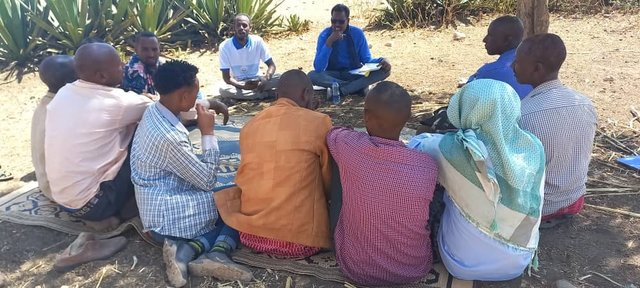
- field visits, field surveys
Three individuals.
- interviews with land users
One person.
- interviews with SLM specialists/ experts
Four individuals.
When were the data compiled (in the field)?
23/03/2023
7.2 References to available publications
Title, author, year, ISBN:
Mekdaschi & Linger, 2013. Freie Universitat Berlin
Available from where? Costs?
https://www.geo.fu-berlin.de/en/v/iwrm/Introduction/Principles/index.html
7.3 Links to relevant online information
Title/ description:
Water-spreading weirs
URL:
https://www.unccd.int/best-practice/water-spreading-weirs
Title/ description:
Water Spreading Weir - NATURAL RESOURCE MANAGEMENT
URL:
https://nrmdblog.wordpress.com/2016/12/12/water-spreading-weir/
7.4 General comments
The questionnaire is inclusive and more relevant to evaluate such physical structures as a technology. However, successive drought seasons experienced in the area subject the fragile soil to be easily detached and immensely moved by the early rains past the structure. This may affect the valuation of the efficiency of the technology since dry areas are also characterized by a flash flood that could certainly mask the benefits of such a good technology.
Links and modules
Expand all Collapse allLinks
Participatory Rehabilitation of Dry Valleys [Ethiopia]
Participatory rehabilitation and productive use of dry valleys is an approach employed to rehabilitate degraded and degradable land. It is operationalised through the Lowland Soil Rehabilitation Project with local development partners from kebele, district, regional agricultural bureaus, and other relevant stakeholders.
- Compiler: GERBA LETA
Modules
No modules