Climate Resilient Irrigation Scheme [Bhutan]
- Creation:
- Update:
- Compiler: Tshering Yangzom
- Editor: chenga Tshering
- Reviewers: William Critchley, Rima Mekdaschi Studer
Namshey Thuendrel Zhingchu
technologies_6849 - Bhutan
View sections
Expand all Collapse all1. General information
1.2 Contact details of resource persons and institutions involved in the assessment and documentation of the Technology
Key resource person(s)
land user:
Dorji Sonam
NA
Bhutan
land user:
Chedup Tenzin
NA
Bhutan
Name of project which facilitated the documentation/ evaluation of the Technology (if relevant)
Strengthening national-level institutional and professional capacities of country Parties towards enhanced UNCCD monitoring and reporting – GEF 7 EA Umbrella II (GEF 7 UNCCD Enabling Activities_Umbrella II)Name of the institution(s) which facilitated the documentation/ evaluation of the Technology (if relevant)
National Soil Services Center, Department of Agric (National Soil Services Center, Department of Agric) - Bhutan1.3 Conditions regarding the use of data documented through WOCAT
The compiler and key resource person(s) accept the conditions regarding the use of data documented through WOCAT:
Yes
1.4 Declaration on sustainability of the described Technology
Is the Technology described here problematic with regard to land degradation, so that it cannot be declared a sustainable land management technology?
No
2. Description of the SLM Technology
2.1 Short description of the Technology
Definition of the Technology:
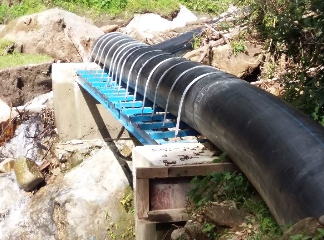
A climate-resilient irrigation scheme is one that aims to successfully cope with and manage the impacts of climate change while preventing those impacts on the scheme from growing worse. The pipes are retrofitted with new and climate-resilient technology. Such a climate-proof irrigation system is designed to better withstand extreme weather conditions.
2.2 Detailed description of the Technology
Description:
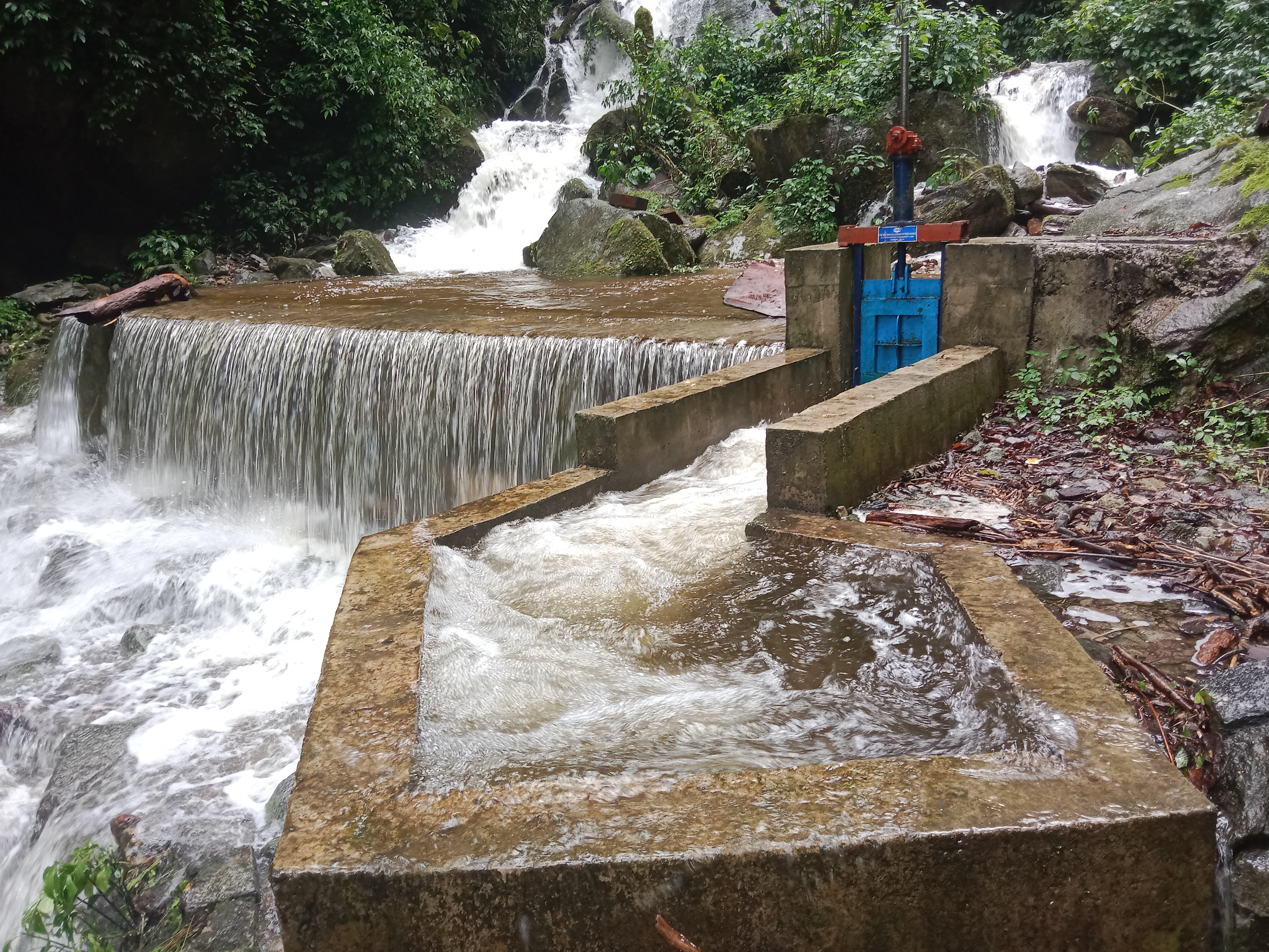
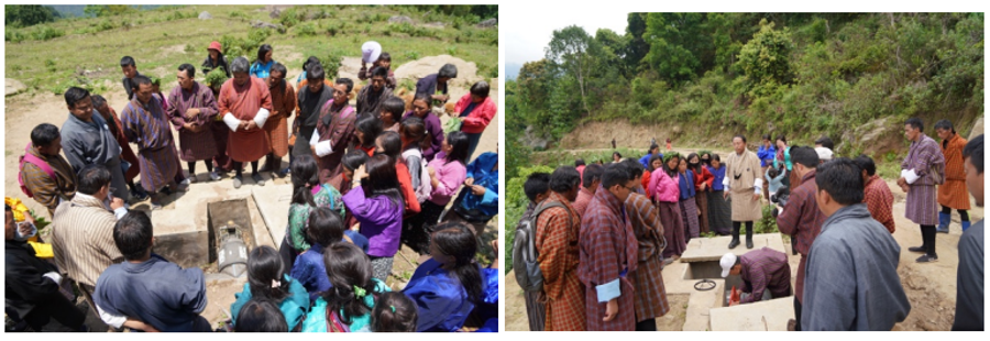
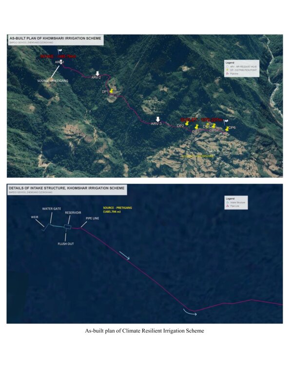
The climate-resilient irrigation scheme in Khomshar Chiwog under Bardho Gewog (Block), Zhemgang Dzongkhag (District), was funded by the Green Climate Fund (GCF), UNDP-Bhutan. The 3.9 km irrigation system was designed with a high-density polyethylene (HDPE) pipe system benefiting 150 households with a command area of 955 acres (approx. 386 ha). The total irrigation cost incurred was Nu. 18,055,180 (approx. USD 225,700) and was completed in 11 months (7 December 2020 - 7 November 2021). The irrigation scheme was officially handed over to the community on 27 August 2021, upon the formation of a water-user group (WUG).
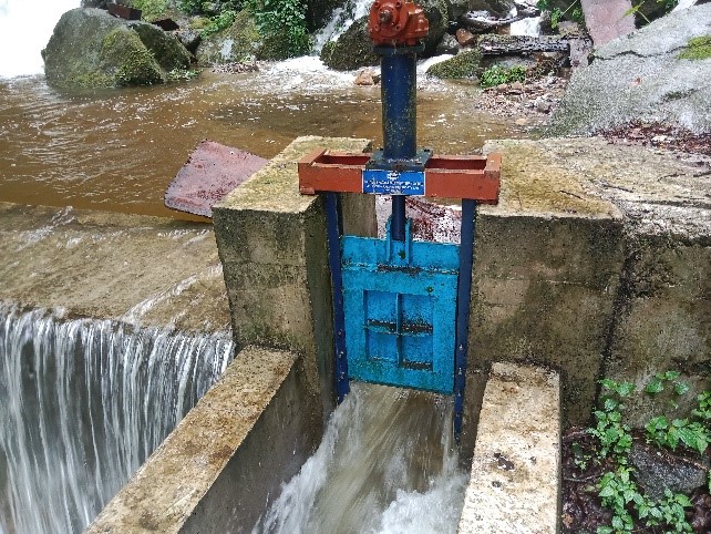
The smart irrigation system consists of key components, viz. intake, sluice gate, silt-cum-inlet tank, flush-out valves, air release valve, water distribution points, and tail point. The intake collects and diverts the water from the source to the sluice gate. The land users were taught to maintain the intake by regularly clearing it from bushes and removing debris. The sluice gate controls the flow of the water into the tank based on the water requirement. The silt-cum-inlet tank holds the water to settle out sediments and debris before clean water flows through the pipe at a constant rate. Flush out valves clear the sediment and debris from the tank. The air release valve vents out the air trapped in the pipe and water distribution points. Water distribution points deliver water to the users, as required, up to the tail point where water is discharged.
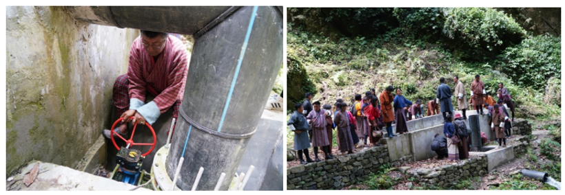
The irrigation scheme fulfils the need for a continuous water supply for both drinking and irrigation purposes. To ensure sustainability, a WUG headed by a chairman, a secretary, and a treasurer was instituted. The WUG ensures operations, maintenance, and harmonious distribution of water. The group is also responsible for the safety of the irrigation system.
The main reason for considering such irrigation scheme as being “climate resilient” is that unlike open earthen channels, this type of irrigation scheme results in zero loss of water through evaporation and leakage, as it is a closed channel. Furthermore, being closed, it is not prone to blockages caused by landslides triggered by rainfall. There is also complete end-to-end management, i.e., management at source including the watershed, and management at tail-end.
The irrigation scheme was constructed by a private company through a contract award: community members were not involved. The irrigation scheme was also accompanied by a land development programme (bench terracing) by a separate contractor, with the prospect of transitioning to irrigated paddy cultivation in the future after adequate soil stabilization. More than 90 acres (36 ha) of fallow lands were revived. This blended approach was applied to ensure the food self-security/sufficiency of the beneficiaries.
Though at a very initial stage, the construction and operation of the irrigation scheme have brought happiness to the beneficiaries. They expressed their hope and expectation of improved crop production, stable and reliable water availability, and major fallow land reversion.
2.3 Photos of the Technology
Media Gallery
2.5 Country/ region/ locations where the Technology has been applied and which are covered by this assessment
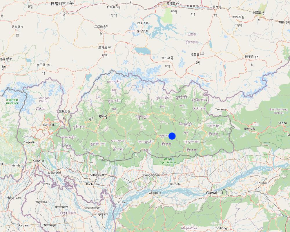
Country:
Bhutan
Region/ State/ Province:
Khomshar Chiwog, Bardho Gewog, Zhemgang Dzongkhag
Specify the spread of the Technology:
- applied at specific points/ concentrated on a small area
Is/are the technology site(s) located in a permanently protected area?
No
Map
×2.6 Date of implementation
Indicate year of implementation:
2021
2.7 Introduction of the Technology
Specify how the Technology was introduced:
- through projects/ external interventions
Comments (type of project, etc.):
The climate-resilient irrigation scheme in the community was supported by a GCF Project, which is a six-year project from 2019-2025. The project promotes climate resilient agricultural practices, integrates climate change risk data into water and land management to support smallholders, and reduce the risk and impact of climate change-induced landslides during extreme events that disrupt market access.
3. Classification of the SLM Technology
3.1 Main purpose(s) of the Technology
- improve production
- protect a watershed/ downstream areas – in combination with other Technologies
- adapt to climate change/ extremes and its impacts
- mitigate climate change and its impacts
- create beneficial economic impact
3.2 Current land use type(s) where the Technology is applied
Land use mixed within the same land unit:
Yes
Specify mixed land use (crops/ grazing/ trees):
- Agroforestry

Cropland
- Annual cropping
- Perennial (non-woody) cropping
- Tree and shrub cropping
Annual cropping - Specify crops:
- cereals - maize
- cereals - rice (wetland)
Perennial (non-woody) cropping - Specify crops:
- banana/plantain/abaca
- herbs, chili, capsicum
Tree and shrub cropping - Specify crops:
- avocado
Number of growing seasons per year:
- 2
Specify:
Maize double cropping
Is intercropping practiced?
No
Is crop rotation practiced?
No

Forest/ woodlands
- (Semi-)natural forests/ woodlands
(Semi-)natural forests/ woodlands: Specify management type:
- Selective felling
- Non-wood forest use
Are the trees specified above deciduous or evergreen?
- mixed deciduous/ evergreen
Products and services:
- Timber
- Fuelwood
- Grazing/ browsing
3.3 Has land use changed due to the implementation of the Technology?
Has land use changed due to the implementation of the Technology?
- Yes (Please fill out the questions below with regard to the land use before implementation of the Technology)
Land use mixed within the same land unit:
No

Other
Specify:
Shrubland
Remarks:
The land use system has changed due to the technology introduction. About 90 acres of shrubland were converted to terraces with the use of an excavator machine, to transition to wetland cultivation in the coming years. Currently, these terraces are in the stabilization stage with the production of dryland crops.
Comments:
The land use system has changed due to the technology introduction. About 90 acres of shrubland were converted to terraces with the use of an excavator machine, to transition to wetland cultivation in the coming years. Currently, these terraces are in the stabilization stage with the production of dryland crops.
3.4 Water supply
Water supply for the land on which the Technology is applied:
- mixed rainfed-irrigated
Comments:
The land users depend both on the irrigation system and the rain for farming.
3.5 SLM group to which the Technology belongs
- irrigation management (incl. water supply, drainage)
3.6 SLM measures comprising the Technology

structural measures
- S7: Water harvesting/ supply/ irrigation equipment
3.7 Main types of land degradation addressed by the Technology

water degradation
- Hs: change in quantity of surface water
- Hp: decline of surface water quality
3.8 Prevention, reduction, or restoration of land degradation
Specify the goal of the Technology with regard to land degradation:
- prevent land degradation
- reduce land degradation
4. Technical specifications, implementation activities, inputs, and costs
4.1 Technical drawing of the Technology
Technical specifications (related to technical drawing):
Source: https://www.bhutangcf.gov.bt/wp-content/uploads/2022/06/Khomshar-WUA_Training-Report.pdf
4.2 General information regarding the calculation of inputs and costs
Specify how costs and inputs were calculated:
- per Technology unit
Specify unit:
Irrigation line
Specify dimensions of unit (if relevant):
Irrigation line: 3.9 km
other/ national currency (specify):
Nu.
If relevant, indicate exchange rate from USD to local currency (e.g. 1 USD = 79.9 Brazilian Real): 1 USD =:
80.0
4.4 Costs and inputs needed for establishment
If you are unable to break down the costs in the table above, give an estimation of the total costs of establishing the Technology:
18055180.0
If land user bore less than 100% of costs, indicate who covered the remaining costs:
Green Climate Fund
Comments:
The cost breakdown is not possible as the activity was carried out through a contract award. However, with the total cost of the establishment being Nu. 18,055,180 (approximately USD 225,700) with a command area of approximately 386 hectares, the amount incurred per ha of irrigable land is around USD 585.
4.5 Maintenance/ recurrent activities
| Activity | Timing/ frequency | |
|---|---|---|
| 1. | Replacement of pipe | One time (just after the completion) |
Comments:
The irrigation scheme was handed over to the community on 14 May 2022. As of now, no major maintenance activities were required except for a portion of pipe replacement (the break down occurred due to a falling boulder), and a few occasional sediment clearing.
4.6 Costs and inputs needed for maintenance/ recurrent activities (per year)
If you are unable to break down the costs in the table above, give an estimation of the total costs of maintaining the Technology:
48000.0
If land user bore less than 100% of costs, indicate who covered the remaining costs:
Royal Government of Bhutan (Gewog budget)
Comments:
The exclusive pipe replacement expenditure was borne by the Gewog Office. The work was allocated to the same contractor.
5. Natural and human environment
5.1 Climate
Annual rainfall
- < 250 mm
- 251-500 mm
- 501-750 mm
- 751-1,000 mm
- 1,001-1,500 mm
- 1,501-2,000 mm
- 2,001-3,000 mm
- 3,001-4,000 mm
- > 4,000 mm
Specifications/ comments on rainfall:
Annual rainfall: 1200-1800 mm
The rain estimate has been derived based on the agro-ecological zone (AEZ) the area falls under. Bhutan is divided into six AEZs (source: https://www.fao.org/3/ad103e/AD103E02.htm).
Bhutan has six AEZs. The wet sub-tropical zone is from 150 to 600 m, followed by the humid sub-tropical zone from 600 to 1,200 m. The dry sub-tropical zone starts at 1,200 m and extends to 1,800 m, followed by the warm temperate zone, which reaches 2,600 m. The cool temperate zone lies between 2,600 and 3,600 m and, finally, the alpine zone between 3,600 m and 4,600 m.
Agro-climatic zone
Dry Sub-tropical Zone in Bhutan
5.2 Topography
Slopes on average:
- flat (0-2%)
- gentle (3-5%)
- moderate (6-10%)
- rolling (11-15%)
- hilly (16-30%)
- steep (31-60%)
- very steep (>60%)
Landforms:
- plateau/plains
- ridges
- mountain slopes
- hill slopes
- footslopes
- valley floors
Altitudinal zone:
- 0-100 m a.s.l.
- 101-500 m a.s.l.
- 501-1,000 m a.s.l.
- 1,001-1,500 m a.s.l.
- 1,501-2,000 m a.s.l.
- 2,001-2,500 m a.s.l.
- 2,501-3,000 m a.s.l.
- 3,001-4,000 m a.s.l.
- > 4,000 m a.s.l.
Indicate if the Technology is specifically applied in:
- concave situations
Comments and further specifications on topography:
Altitude: 1319 m a.s.l.
5.3 Soils
Soil depth on average:
- very shallow (0-20 cm)
- shallow (21-50 cm)
- moderately deep (51-80 cm)
- deep (81-120 cm)
- very deep (> 120 cm)
Soil texture (topsoil):
- coarse/ light (sandy)
- fine/ heavy (clay)
Soil texture (> 20 cm below surface):
- coarse/ light (sandy)
- fine/ heavy (clay)
Topsoil organic matter:
- high (>3%)
If available, attach full soil description or specify the available information, e.g. soil type, soil PH/ acidity, Cation Exchange Capacity, nitrogen, salinity etc.
Moisture content-5.41%
Organic matter-5.48 %
Organic carbon-3.18%
pH-6.25
Electrical conductivity-368.97 µs/cm
Nitrogen-0.16
Phosphorus-0.33
Potassium-80.10 mg/100ml
Soil texture-Sand Clay Loam
5.4 Water availability and quality
Ground water table:
5-50 m
Availability of surface water:
good
Water quality (untreated):
good drinking water
Water quality refers to:
surface water
Is water salinity a problem?
No
Is flooding of the area occurring?
No
Comments and further specifications on water quality and quantity:
The source of the water serve for both drinking and irrigation purposes.
5.5 Biodiversity
Species diversity:
- high
Habitat diversity:
- high
Comments and further specifications on biodiversity:
The rich periphery environment, higher vegetation coverage, and evident agroforestry indicate high species and habitat diversity.
5.6 Characteristics of land users applying the Technology
Sedentary or nomadic:
- Sedentary
Market orientation of production system:
- subsistence (self-supply)
Off-farm income:
- 10-50% of all income
Relative level of wealth:
- average
Individuals or groups:
- groups/ community
Level of mechanization:
- animal traction
- mechanized/ motorized
Gender:
- women
- men
Age of land users:
- youth
- middle-aged
5.7 Average area of land used by land users applying the Technology
- < 0.5 ha
- 0.5-1 ha
- 1-2 ha
- 2-5 ha
- 5-15 ha
- 15-50 ha
- 50-100 ha
- 100-500 ha
- 500-1,000 ha
- 1,000-10,000 ha
- > 10,000 ha
Is this considered small-, medium- or large-scale (referring to local context)?
- medium-scale
Comments:
The average land holding area of the community ranges from 5 to 6 acres, falling under large-scale based on the local context.
In general, the average household land holding in Bhutan is 3 acres.
In the local context:
3 acres (1.2 ha) = medium scale
> 3 acres = large-scale
<3 acres = small-scale
5.8 Land ownership, land use rights, and water use rights
- Family land
Land use rights:
- individual
Water use rights:
- communal (organized)
Are land use rights based on a traditional legal system?
Yes
Specify:
The land use rights in Bhutan is based on a traditional legal system guided by formal land act and land rules and regulations.
5.9 Access to services and infrastructure
health:
- poor
- moderate
- good
education:
- poor
- moderate
- good
technical assistance:
- poor
- moderate
- good
employment (e.g. off-farm):
- poor
- moderate
- good
markets:
- poor
- moderate
- good
energy:
- poor
- moderate
- good
roads and transport:
- poor
- moderate
- good
drinking water and sanitation:
- poor
- moderate
- good
financial services:
- poor
- moderate
- good
6. Impacts and concluding statements
6.1 On-site impacts the Technology has shown
Socio-economic impacts
Production
crop production
Quantity before SLM:
250-300 Drey from one acre paddy land
Quantity after SLM:
600-700 Drey from one acre
Comments/ specify:
The old conventional irrigation channel used to suffer multiple breakdowns quite often. Due to this most of the paddy fields were left fallow (30%) because of insufficient irrigation water. Currently, all the wetlands (100%) are brought under cultivation. Hence, the production has been enhanced.
Note: Drey is a traditional grain measuring container. One Drey is about 1.5 kg.
crop quality
Comments/ specify:
The paddy harvest appears to be of better quality when there is enough irrigation. Otherwise, the growths are hampered, resulting in higher vegetative growths only.
fodder production
Comments/ specify:
The higher hay production (by-product) has been beneficial for farmers to feed livestock.
animal production
Comments/ specify:
Safe and readily available water to feed the livestock, facilitated by the irrigation scheme has enhanced animal production. Earlier, the farmers used to depend on the far-flung streams/ponds.
land management
Comments/ specify:
Better access to irrigation water has motivated farmers to adopt land development. Hence, about 90 acres of fallow lands in the community have been revived through new terrace constructions.
Water availability and quality
drinking water availability
Comments/ specify:
The irrigation water is being used for drinking purposes too. The drinking water quantity has been enhanced. Earlier, the drinking water source was not enough to meet the requirements due to higher households, especially in winter.
drinking water quality
Comments/ specify:
The drinking water tapped from this irrigation is clean and hygienic, unlike before.
water availability for livestock
water quality for livestock
irrigation water availability
irrigation water quality
demand for irrigation water
Comments/ specify:
Due to new terrace construction, the demand for irrigation water has increased.
Income and costs
expenses on agricultural inputs
Comments/ specify:
One acre of paddy cultivation used to take 4-5 days. Now, one acre takes 1 day. Mechanization is enhanced.
farm income
Comments/ specify:
Currently, the impact is at the initial stage (1 year). The income could quantified in the later years.
Socio-cultural impacts
cultural opportunities
Comments/ specify:
Irrigation and land development interventions have beautified the community (aesthetic). The external visitors are astonished.
SLM/ land degradation knowledge
conflict mitigation
Comments/ specify:
Community dispute over water demand and mid night water guarding during paddy cultivation due to water scarcity used to be rampant before.
situation of socially and economically disadvantaged groups
Ecological impacts
Water cycle/ runoff
water quantity
water quality
Soil
soil moisture
Biodiversity: vegetation, animals
biomass/ above ground C
Climate and disaster risk reduction
flood impacts
Comments/ specify:
The conventional irrigation channel used to result in water seepage and accumulation of groundwater, leading to flooding of underneath fields. Now, this pipe irrigation has been solved and flooding is not evident.
landslides/ debris flows
Comments/ specify:
Due to improper irrigation source management before, the water outflow was used to wash away a huge portion of lands and roads below. Due to enhanced source protection, this issue is solved.
6.3 Exposure and sensitivity of the Technology to gradual climate change and climate-related extremes/ disasters (as perceived by land users)
Gradual climate change
Gradual climate change
| Season | increase or decrease | How does the Technology cope with it? | |
|---|---|---|---|
| annual temperature | increase | very well | |
| annual rainfall | increase | very well |
Climate-related extremes (disasters)
Meteorological disasters
| How does the Technology cope with it? | |
|---|---|
| local rainstorm | very well |
| local thunderstorm | very well |
| local windstorm | very well |
Climatological disasters
| How does the Technology cope with it? | |
|---|---|
| extreme winter conditions | very well |
Hydrological disasters
| How does the Technology cope with it? | |
|---|---|
| landslide | very well |
Comments:
The respondents pointed out that the current rainfall pattern has changed compared to the past 10 - 15 years. Before, there used to be steady and enough rain. Now, the dry days continue for quite a long time and when rain comes, it's sudden and very heavy.
6.4 Cost-benefit analysis
How do the benefits compare with the establishment costs (from land users’ perspective)?
Short-term returns:
very positive
Long-term returns:
very positive
How do the benefits compare with the maintenance/ recurrent costs (from land users' perspective)?
Short-term returns:
very positive
Long-term returns:
very positive
6.5 Adoption of the Technology
- > 50%
If available, quantify (no. of households and/ or area covered):
150
Of all those who have adopted the Technology, how many did so spontaneously, i.e. without receiving any material incentives/ payments?
- 0-10%
6.6 Adaptation
Has the Technology been modified recently to adapt to changing conditions?
No
6.7 Strengths/ advantages/ opportunities of the Technology
| Strengths/ advantages/ opportunities in the land user’s view |
|---|
| Enough irrigation and drinking water compared to earlier conventional system. |
| Fallow land reversion is being enhanced. |
| Cleanliness (social hygiene) due to better water availability. |
| Strengths/ advantages/ opportunities in the compiler’s or other key resource person’s view |
|---|
| Fallow land reversion is being enhanced. |
6.8 Weaknesses/ disadvantages/ risks of the Technology and ways of overcoming them
| Weaknesses/ disadvantages/ risks in the land user’s view | How can they be overcome? |
|---|---|
| Risk of source destruction due to landslide. | Shifting the current source tank to a different location. |
| No proper filtration at the source. Currently, a locally fabricated filter is being used. | Permanent filter is required. |
| Weaknesses/ disadvantages/ risks in the compiler’s or other key resource person’s view | How can they be overcome? |
|---|---|
| The road leading to source, constructed exclusively to monitor the irrigation line is not being maintained well. | Timely road maintenance by the beneficiaries. |
| The source tank premise needs proper fencing to avoid casualties. | Fencing the irrigation source premises. |
7. References and links
7.1 Methods/ sources of information
- field visits, field surveys
Two
- interviews with land users
Two
When were the data compiled (in the field)?
12/07/2023
7.3 Links to relevant online information
Title/ description:
Formation and Training Report on Khomshar Water-User Group and the Bylaws for the Khomshar Irrigation Scheme in Bardo Gewog under Zhemgang Dzongkhag
URL:
https://www.bhutangcf.gov.bt/wp-content/uploads/2022/06/Khomshar-WUA_Training-Report.pdf
Links and modules
Expand all Collapse allLinks
No links
Modules
No modules