Climate Resilient Irrigation Scheme [ภูฏาน]
- ผู้สร้างสรรค์:
- การอัพเดท:
- ผู้รวบรวม: Tshering Yangzom
- ผู้เรียบเรียง: chenga Tshering
- ผู้ตรวจสอบ: William Critchley, Rima Mekdaschi Studer
Namshey Thuendrel Zhingchu
technologies_6849 - ภูฏาน
ดูส่วนย่อย
ขยายทั้งหมด ย่อทั้งหมด1. ข้อมูลทั่วไป
1.2 รายละเอียดที่ติดต่อได้ของผู้รวบรวมและองค์กรที่เกี่ยวข้องในการประเมินและการจัดเตรียมทำเอกสารของเทคโนโลยี
วิทยากรหลัก
ผู้ใช้ที่ดิน:
Dorji Sonam
NA
ภูฏาน
ผู้ใช้ที่ดิน:
Chedup Tenzin
NA
ภูฏาน
ชื่อของโครงการซึ่งอำนวยความสะดวกในการทำเอกสารหรือการประเมินเทคโนโลยี (ถ้าเกี่ยวข้อง)
Strengthening national-level institutional and professional capacities of country Parties towards enhanced UNCCD monitoring and reporting – GEF 7 EA Umbrella II (GEF 7 UNCCD Enabling Activities_Umbrella II)ชื่อขององค์กรซึ่งอำนวยความสะดวกในการทำเอกสารหรือการประเมินเทคโนโลยี (ถ้าเกี่ยวข้อง)
National Soil Services Center, Department of Agric (National Soil Services Center, Department of Agric) - ภูฏาน1.3 เงื่อนไขการใช้ข้อมูลที่ได้บันทึกผ่านทาง WOCAT
ผู้รวบรวมและวิทยากรหลักยอมรับเงื่อนไขเกี่ยวกับการใช้ข้อมูลที่ถูกบันทึกผ่านทาง WOCAT:
ใช่
1.4 การเปิดเผยเรื่องความยั่งยืนของเทคโนโลยีที่ได้อธิบายไว้
เทคโนโลยีที่ได้อธิบายไว้นี้เป็นปัญหาของความเสื่อมโทรมโทรมของที่ดินหรือไม่ จึงไม่ได้รับการยอมรับว่าเป็นเทคโนโลยีเพื่อการจัดการที่ดินอย่างยั่งยืน:
ไม่ใช่
2. การอธิบายลักษณะของเทคโนโลยี SLM
2.1 การอธิบายแบบสั้น ๆ ของเทคโนโลยี
คำจำกัดความของเทคโนโลยี:
A climate-resilient irrigation scheme is one that aims to successfully cope with and manage the impacts of climate change while preventing those impacts on the scheme from growing worse. The pipes are retrofitted with new and climate-resilient technology. Such a climate-proof irrigation system is designed to better withstand extreme weather conditions.
2.2 การอธิบายแบบละเอียดของเทคโนโลยี
คำอธิบาย:
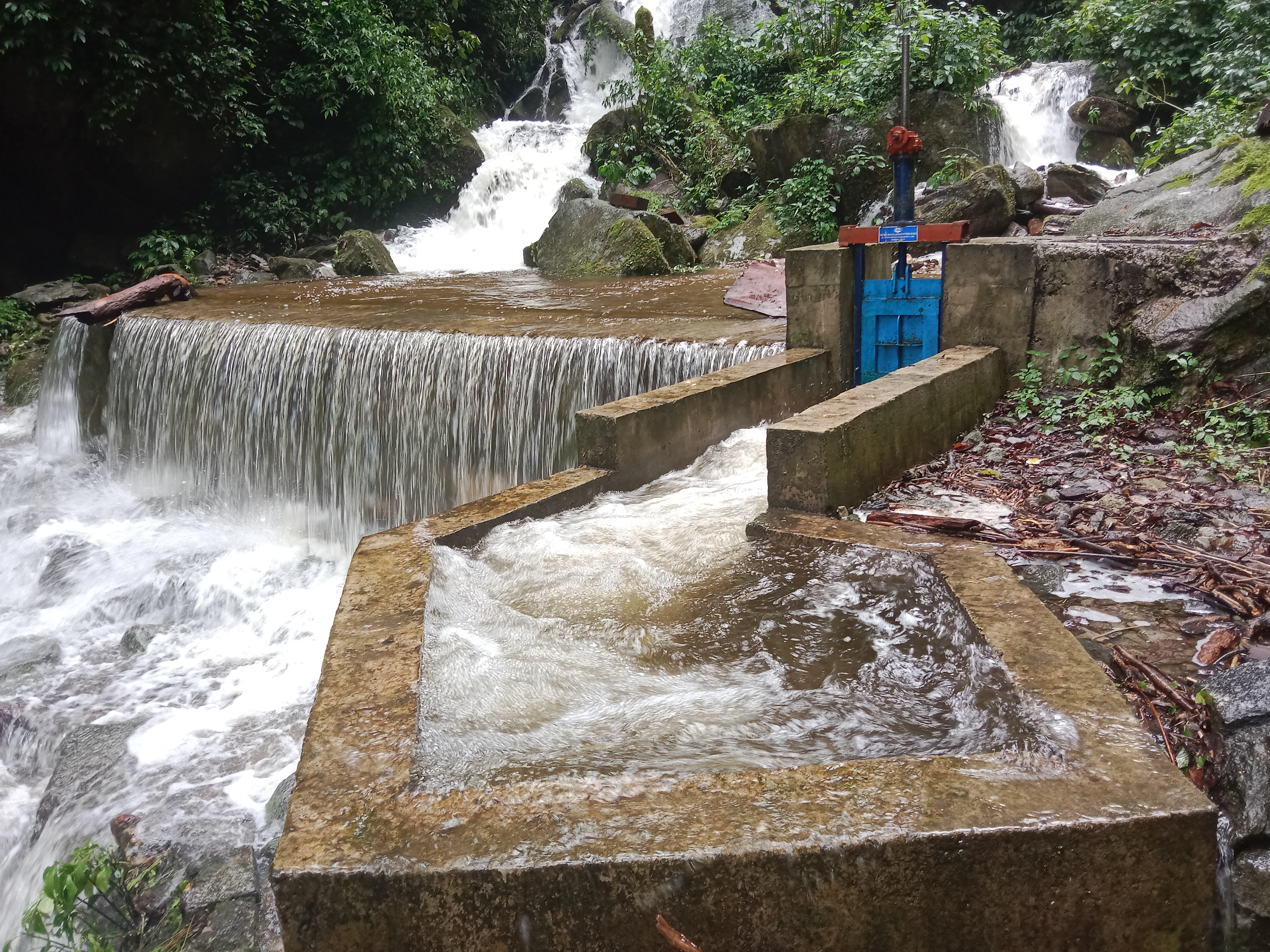
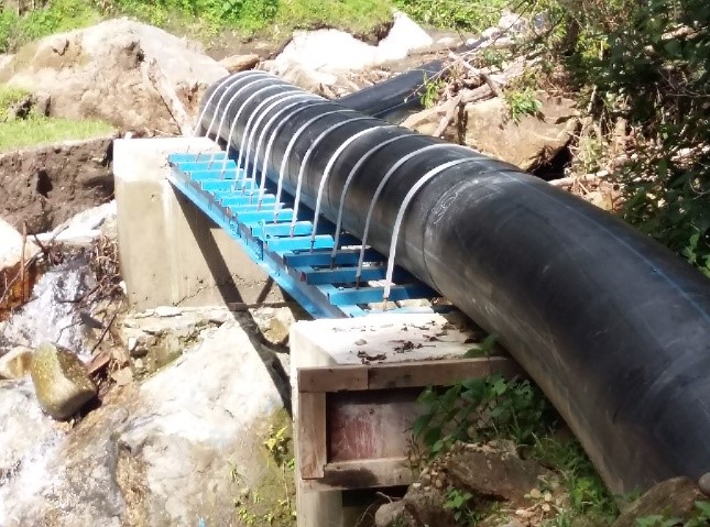
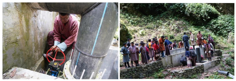
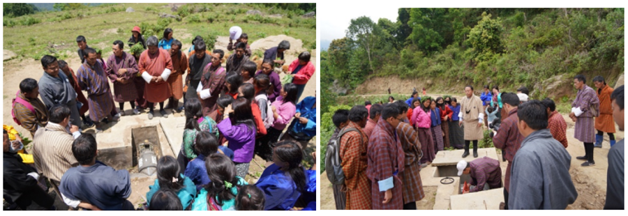
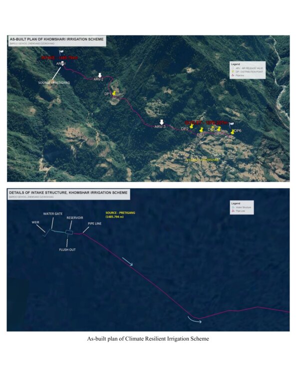
The climate-resilient irrigation scheme in Khomshar Chiwog under Bardho Gewog (Block), Zhemgang Dzongkhag (District), was funded by the Green Climate Fund (GCF), UNDP-Bhutan. The 3.9 km irrigation system was designed with a high-density polyethylene (HDPE) pipe system benefiting 150 households with a command area of 955 acres (approx. 386 ha). The total irrigation cost incurred was Nu. 18,055,180 (approx. USD 225,700) and was completed in 11 months (7 December 2020 - 7 November 2021). The irrigation scheme was officially handed over to the community on 27 August 2021, upon the formation of a water-user group (WUG).
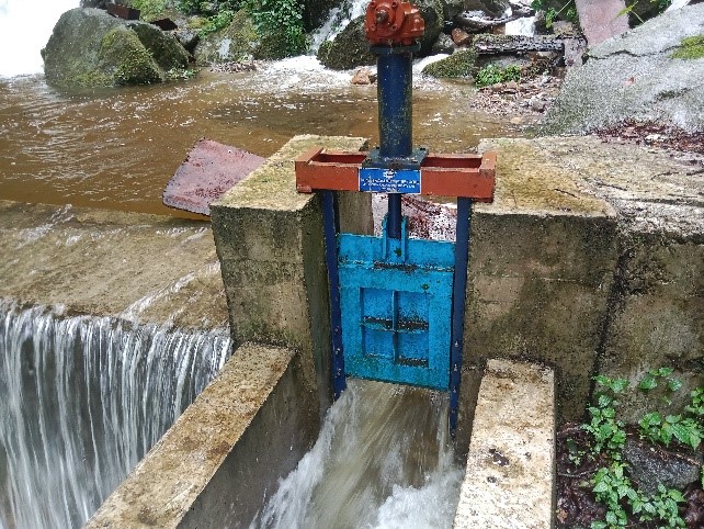
The smart irrigation system consists of key components, viz. intake, sluice gate, silt-cum-inlet tank, flush-out valves, air release valve, water distribution points, and tail point. The intake collects and diverts the water from the source to the sluice gate. The land users were taught to maintain the intake by regularly clearing it from bushes and removing debris. The sluice gate controls the flow of the water into the tank based on the water requirement. The silt-cum-inlet tank holds the water to settle out sediments and debris before clean water flows through the pipe at a constant rate. Flush out valves clear the sediment and debris from the tank. The air release valve vents out the air trapped in the pipe and water distribution points. Water distribution points deliver water to the users, as required, up to the tail point where water is discharged.
The irrigation scheme fulfils the need for a continuous water supply for both drinking and irrigation purposes. To ensure sustainability, a WUG headed by a chairman, a secretary, and a treasurer was instituted. The WUG ensures operations, maintenance, and harmonious distribution of water. The group is also responsible for the safety of the irrigation system.
The main reason for considering such irrigation scheme as being “climate resilient” is that unlike open earthen channels, this type of irrigation scheme results in zero loss of water through evaporation and leakage, as it is a closed channel. Furthermore, being closed, it is not prone to blockages caused by landslides triggered by rainfall. There is also complete end-to-end management, i.e., management at source including the watershed, and management at tail-end.
The irrigation scheme was constructed by a private company through a contract award: community members were not involved. The irrigation scheme was also accompanied by a land development programme (bench terracing) by a separate contractor, with the prospect of transitioning to irrigated paddy cultivation in the future after adequate soil stabilization. More than 90 acres (36 ha) of fallow lands were revived. This blended approach was applied to ensure the food self-security/sufficiency of the beneficiaries.
Though at a very initial stage, the construction and operation of the irrigation scheme have brought happiness to the beneficiaries. They expressed their hope and expectation of improved crop production, stable and reliable water availability, and major fallow land reversion.
2.3 รูปภาพของเทคโนโลยี
อัลบั้มสื่อบันทึก
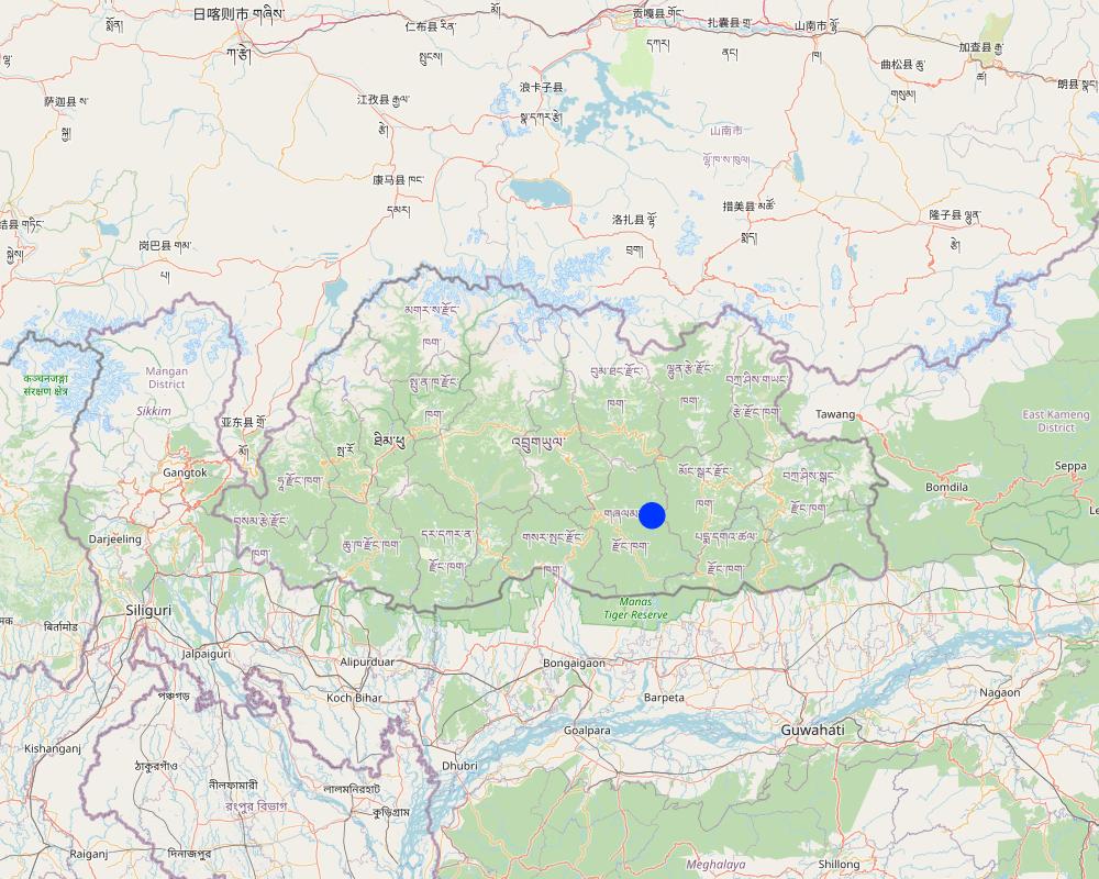
2.5 ประเทศภูมิภาค หรือสถานที่ตั้งที่เทคโนโลยีได้นำไปใช้และได้รับการครอบคลุมโดยการประเมินนี้
ประเทศ:
ภูฏาน
ภูมิภาค/รัฐ/จังหวัด:
Khomshar Chiwog, Bardho Gewog, Zhemgang Dzongkhag
ระบุการกระจายตัวของเทคโนโลยี:
- ใช้ ณ จุดที่เฉพาะเจาะจงหรือเน้นไปยังบริเวณพื้นที่ขนาดเล็ก
Is/are the technology site(s) located in a permanently protected area?
ไม่ใช่
Map
×2.6 วันที่การดำเนินการ
ระบุปีที่ใช้:
2021
2.7 คำแนะนำของเทคโนโลยี
ให้ระบุว่าเทคโนโลยีถูกแนะนำเข้ามาอย่างไร:
- ทางโครงการหรือจากภายนอก
ความคิดเห็น (ประเภทของโครงการ เป็นต้น) :
The climate-resilient irrigation scheme in the community was supported by a GCF Project, which is a six-year project from 2019-2025. The project promotes climate resilient agricultural practices, integrates climate change risk data into water and land management to support smallholders, and reduce the risk and impact of climate change-induced landslides during extreme events that disrupt market access.
3. การจัดประเภทของเทคโนโลยี SLM
3.1 วัตถุประสงค์หลักของเทคโนโลยี
- ปรับปรุงการผลิตให้ดีขึ้น
- ป้องกันพื้นที่ลุ่มน้ำ/บริเวณท้ายน้ำ โดยร่วมกับเทคโนโลยีอื่นๆ
- ปรับตัวเข้ากับการเปลี่ยนแปลงภูมิอากาศของโลก สภาพภูมิอากาศที่รุนแรงและผลกระทบ
- ชะลอการเปลี่ยนแปลงภูมิอากาศของโลกและผลกระทบ
- สร้างผลกระทบทางด้านเศรษฐกิจที่เป็นประโยชน์
3.2 ประเภทของการใช้ที่ดินในปัจจุบันที่ได้นำเทคโนโลยีไปใช้
Land use mixed within the same land unit:
ใช่
Specify mixed land use (crops/ grazing/ trees):
- วนเกษตร (Agroforestry)

พื้นที่ปลูกพืช
- การปลูกพืชล้มลุกอายุปีเดียว
- การปลูกพืชยืนต้นที่ไม่มีเนื้อไม้
- การปลูกไม้ยืนต้น ไม้พุ่ม
Annual cropping - Specify crops:
- cereals - maize
- cereals - rice (wetland)
Perennial (non-woody) cropping - Specify crops:
- banana/plantain/abaca
- herbs, chili, capsicum
Tree and shrub cropping - Specify crops:
- avocado
จำนวนของฤดูเพาะปลูกต่อปี:
- 2
ระบุ:
Maize double cropping
Is intercropping practiced?
ไม่ใช่
Is crop rotation practiced?
ไม่ใช่

ป่า/พื้นที่ทำไม้
- ป่ากึ่งธรรมชาติ / พื้นที่ทำไม้
(Semi-)natural forests/ woodlands: Specify management type:
- การตัดไม้ที่มีคัดเลือก (Selective felling)
- การใช้ประโยชน์จากป่า ยกเว้นไม้
Are the trees specified above deciduous or evergreen?
- mixed deciduous/ evergreen
ผลิตภัณฑ์และบริการ:
- ไม้ซุง
- ไม้ที่นำมาทำเป็นเชื้อเพลิง
- การแทะเล็มหญ้า / การเก็บกินหญ้า
3.3 Has land use changed due to the implementation of the Technology?
Has land use changed due to the implementation of the Technology?
- Yes (Please fill out the questions below with regard to the land use before implementation of the Technology)
Land use mixed within the same land unit:
ไม่ใช่

อื่น ๆ
ระบุ:
Shrubland
ข้อสังเกต:
The land use system has changed due to the technology introduction. About 90 acres of shrubland were converted to terraces with the use of an excavator machine, to transition to wetland cultivation in the coming years. Currently, these terraces are in the stabilization stage with the production of dryland crops.
แสดงความคิดเห็น:
The land use system has changed due to the technology introduction. About 90 acres of shrubland were converted to terraces with the use of an excavator machine, to transition to wetland cultivation in the coming years. Currently, these terraces are in the stabilization stage with the production of dryland crops.
3.4 การใช้น้ำ
การใช้น้ำของที่ดินที่มีการใช้เทคโนโลยีอยู่:
- น้ำฝนร่วมกับการชลประทาน
แสดงความคิดเห็น:
The land users depend both on the irrigation system and the rain for farming.
3.5 กลุ่ม SLM ที่ตรงกับเทคโนโลยีนี้
- การจัดการด้านชลประทาน (รวมถึงการลำเลียงส่งน้ำ การระบายน้ำ)
3.6 มาตรการ SLM ที่ประกอบกันเป็นเทคโนโลยี

มาตรการอนุรักษ์ด้วยโครงสร้าง
- S7: การกักเก็บน้ำ/การส่งลำเลียง/อุปกรณ์การชลประทาน
3.7 รูปแบบหลักของการเสื่อมโทรมของที่ดินที่ได้รับการแก้ไขโดยเทคโนโลยี

การเสื่อมโทรมของน้ำ
- Hs (Change in quantity of surface water): การเปลี่ยนแปลงปริมาณของน้ำที่ผิวดิน
- Hp (Decline of surface water quality): การลดลงของคุณภาพน้ำที่ผิวดิน
3.8 การป้องกัน การลดลง หรือการฟื้นฟูความเสื่อมโทรมของที่ดิน
ระบุเป้าหมายของเทคโนโลยีกับความเสื่อมโทรมของที่ดิน:
- ป้องกันความเสื่อมโทรมของที่ดิน
- ลดความเสื่อมโทรมของดิน
4. ข้อมูลจำเพาะด้านเทคนิค กิจกรรมการนำไปปฏิบัติใช้ ปัจจัยนำเข้า และค่าใช้จ่าย
4.1 แบบแปลนทางเทคนิคของเทคโนโลยี
ข้อมูลจำเพาะด้านเทคนิค (แบบแปลนทางเทคนิคของเทคโนโลยี):
Source: https://www.bhutangcf.gov.bt/wp-content/uploads/2022/06/Khomshar-WUA_Training-Report.pdf
4.2 ข้อมูลทั่วไปเกี่ยวกับการคำนวณปัจจัยนำเข้าและค่าใช้จ่าย
ให้ระบุว่าค่าใช้จ่ายและปัจจัยนำเข้าได้รับการคำนวณอย่างไร:
- ต่อหน่วยเทคโนโลยี
โปรดระบุหน่วย:
Irrigation line
Specify dimensions of unit (if relevant):
Irrigation line: 3.9 km
อื่นๆ หรือสกุลเงินประจำชาติ (ระบุ):
Nu.
If relevant, indicate exchange rate from USD to local currency (e.g. 1 USD = 79.9 Brazilian Real): 1 USD =:
80.0
4.4 ค่าใช้จ่ายของปัจจัยนำเข้าที่จำเป็นสำหรับการจัดตั้ง
If you are unable to break down the costs in the table above, give an estimation of the total costs of establishing the Technology:
18055180.0
ถ้าผู้ใช้ที่ดินรับภาระน้อยกว่า 100% ของค่าใช้จ่าย ให้ระบุว่าใครเป็นผู้รับผิดชอบส่วนที่เหลือ:
Green Climate Fund
แสดงความคิดเห็น:
The cost breakdown is not possible as the activity was carried out through a contract award. However, with the total cost of the establishment being Nu. 18,055,180 (approximately USD 225,700) with a command area of approximately 386 hectares, the amount incurred per ha of irrigable land is around USD 585.
4.5 การบำรุงรักษาสภาพหรือกิจกรรมที่เกิดขึ้นเป็นประจำ
| กิจกรรม | ช่วงระยะเวลา/ความถี่ | |
|---|---|---|
| 1. | Replacement of pipe | One time (just after the completion) |
แสดงความคิดเห็น:
The irrigation scheme was handed over to the community on 14 May 2022. As of now, no major maintenance activities were required except for a portion of pipe replacement (the break down occurred due to a falling boulder), and a few occasional sediment clearing.
4.6 ค่าใช้จ่ายของปัจจัยนำเข้าและกิจกรรมที่เกิดขึ้นเป็นประจำที่ต้องการการบำรุงรักษา (ต่อปี)
If you are unable to break down the costs in the table above, give an estimation of the total costs of maintaining the Technology:
48000.0
ถ้าผู้ใช้ที่ดินรับภาระน้อยกว่า 100% ของค่าใช้จ่าย ให้ระบุว่าใครเป็นผู้รับผิดชอบส่วนที่เหลือ:
Royal Government of Bhutan (Gewog budget)
แสดงความคิดเห็น:
The exclusive pipe replacement expenditure was borne by the Gewog Office. The work was allocated to the same contractor.
5. สิ่งแวดล้อมทางธรรมชาติและของมนุษย์
5.1 ภูมิอากาศ
ฝนประจำปี
- < 250 ม.ม.
- 251-500 ม.ม.
- 501-750 ม.ม.
- 751-1,000 ม.ม.
- 1,001-1,500 ม.ม.
- 1,501-2,000 ม.ม.
- 2,001-3,000 ม.ม.
- 3,001-4,000 ม.ม.
- > 4,000 ม.ม.
ข้อมูลจำเพาะ/ความคิดเห็นเรื่องปริมาณน้ำฝน:
Annual rainfall: 1200-1800 mm
The rain estimate has been derived based on the agro-ecological zone (AEZ) the area falls under. Bhutan is divided into six AEZs (source: https://www.fao.org/3/ad103e/AD103E02.htm).
Bhutan has six AEZs. The wet sub-tropical zone is from 150 to 600 m, followed by the humid sub-tropical zone from 600 to 1,200 m. The dry sub-tropical zone starts at 1,200 m and extends to 1,800 m, followed by the warm temperate zone, which reaches 2,600 m. The cool temperate zone lies between 2,600 and 3,600 m and, finally, the alpine zone between 3,600 m and 4,600 m.
เขตภูมิอากาศเกษตร
Dry Sub-tropical Zone in Bhutan
5.2 สภาพภูมิประเทศ
ค่าเฉลี่ยความลาดชัน:
- ราบเรียบ (0-2%)
- ลาดที่ไม่ชัน (3-5%)
- ปานกลาง (6-10%)
- เป็นลูกคลื่น (11-15%)
- เป็นเนิน (16-30%)
- ชัน (31-60%)
- ชันมาก (>60%)
ธรณีสัณฐาน:
- ที่ราบสูง/ที่ราบ
- สันเขา
- ไหล่เขา
- ไหล่เนินเขา
- ตีนเนิน
- หุบเขา
ระดับความสูง:
- 0-100 เมตร
- 101-500 เมตร
- 501-1,000 เมตร
- 1,001-1,500 เมตร
- 1,501-2,000 เมตร
- 2,001-2,500 เมตร
- 2,501-3,000 เมตร
- 3,001-4,000 เมตร
- > 4,000 เมตร
ให้ระบุถ้าเทคโนโลยีได้ถูกนำไปใช้:
- บริเวณแอ่งบนที่ราบ (concave situations)
ความคิดเห็นและข้อมูลจำเพาะเพิ่มเติมเรื่องสภาพภูมิประเทศ:
Altitude: 1319 m a.s.l.
5.3 ดิน
ค่าเฉลี่ยความลึกของดิน:
- ตื้นมาก (0-20 ซ.ม.)
- ตื้น (21-50 ซ.ม.)
- ลึกปานกลาง (51-80 ซ.ม.)
- ลึก (81-120 ซ.ม.)
- ลึกมาก (>120 ซ.ม.)
เนื้อดิน (ดินชั้นบน):
- หยาบ/เบา (ดินทราย)
- ละเอียด/หนัก (ดินเหนียว)
เนื้อดินล่าง (> 20 ซ.ม.ต่ำจากผิวดิน):
- หยาบ/เบา (ดินทราย)
- ละเอียด/หนัก (ดินเหนียว)
อินทรียวัตถุในดิน:
- สูง (>3%)
(ถ้ามี) ให้แนบคำอธิบายเรื่องดินแบบเต็มหรือระบุข้อมูลที่มีอยู่ เช่น ชนิดของดิน ค่า pH ของดินหรือความเป็นกรดของดิน ความสามารถในการแลกเปลี่ยนประจุบวก ไนโตรเจน ความเค็ม เป็นต้น:
Moisture content-5.41%
Organic matter-5.48 %
Organic carbon-3.18%
pH-6.25
Electrical conductivity-368.97 µs/cm
Nitrogen-0.16
Phosphorus-0.33
Potassium-80.10 mg/100ml
Soil texture-Sand Clay Loam
5.4 ความเป็นประโยชน์และคุณภาพของน้ำ
ระดับน้ำใต้ดิน:
5-50 เมตร
น้ำไหลบ่าที่ผิวดิน:
ดี
คุณภาพน้ำ (ที่ยังไม่ได้บำบัด):
เป็นน้ำเพื่อการดื่มที่ดี
Water quality refers to:
surface water
ความเค็มของน้ำเป็นปัญหาหรือไม่:
ไม่ใช่
กำลังเกิดน้ำท่วมในพื้นที่หรือไม่:
ไม่ใช่
ความคิดเห็นและข้อมูลจำเพาะเพิ่มเติมเรื่องคุณภาพและปริมาณน้ำ:
The source of the water serve for both drinking and irrigation purposes.
5.5 ความหลากหลายทางชีวภาพ
ความหลากหลายทางชนิดพันธุ์:
- สูง
ความหลากหลายของแหล่งที่อยู่:
- สูง
ความคิดเห็นและข้อมูลจำเพาะเพิ่มเติมของความหลากหลายทางชีวภาพ:
The rich periphery environment, higher vegetation coverage, and evident agroforestry indicate high species and habitat diversity.
5.6 ลักษณะของผู้ใช้ที่ดินที่นำเทคโนโลยีไปปฏิบัติใช้
อยู่กับที่หรือเร่ร่อน:
- อยู่กับที่
แนวทางการตลาดของระบบการผลิต:
- เพื่อการยังชีพ (หาเลี้ยงตนเอง)
รายได้ที่มาจากนอกฟาร์ม:
- 10-50% ของรายได้ทั้งหมด
ระดับของความมั่งคั่งโดยเปรียบเทียบ:
- พอมีพอกิน
เป็นรายบุคคล/ครัวเรือน:
- กลุ่ม/ชุมชน
ระดับของการใช้เครื่องจักรกล:
- การใช้กำลังจากสัตว์
- การใช้เครื่องจักรหรือเครื่องยนต์
เพศ:
- หญิง
- ชาย
อายุของผู้ใช้ที่ดิน:
- ผู้เยาว์
- วัยกลางคน
5.7 Average area of land used by land users applying the Technology
- < 0.5 เฮกตาร์
- 0.5-1 เฮกตาร์
- 1-2 เฮกตาร์
- 2-5 เฮกตาร์
- 5-15 เฮกตาร์
- 15-50 เฮกตาร์
- 50-100 เฮกตาร์
- 100-500 เฮกตาร์
- 500-1,000 เฮกตาร์
- 1,000-10,000 เฮกตาร์
- >10,000 เฮกตาร์
พิจารณาว่าเป็นขนาดเล็ก กลาง หรือขนาดใหญ่ (ซึ่งอ้างอิงถึงบริบทระดับท้องถิ่น):
- ขนาดกลาง
แสดงความคิดเห็น:
The average land holding area of the community ranges from 5 to 6 acres, falling under large-scale based on the local context.
In general, the average household land holding in Bhutan is 3 acres.
In the local context:
3 acres (1.2 ha) = medium scale
> 3 acres = large-scale
<3 acres = small-scale
5.8 กรรมสิทธิ์ในที่ดิน สิทธิในการใช้ที่ดินและสิทธิในการใช้น้ำ
- Family land
สิทธิในการใช้ที่ดิน:
- รายบุคคล
สิทธิในการใช้น้ำ:
- เกี่ยวกับชุมชน (ถูกจัดระเบียบ)
Are land use rights based on a traditional legal system?
ใช่
ระบุ:
The land use rights in Bhutan is based on a traditional legal system guided by formal land act and land rules and regulations.
5.9 การเข้าถึงบริการและโครงสร้างพื้นฐาน
สุขภาพ:
- จน
- ปานกลาง
- ดี
การศึกษา:
- จน
- ปานกลาง
- ดี
ความช่วยเหลือทางด้านเทคนิค:
- จน
- ปานกลาง
- ดี
การจ้างงาน (เช่น ภายนอกฟาร์ม):
- จน
- ปานกลาง
- ดี
ตลาด:
- จน
- ปานกลาง
- ดี
พลังงาน:
- จน
- ปานกลาง
- ดี
ถนนและการขนส่ง:
- จน
- ปานกลาง
- ดี
น้ำดื่มและการสุขาภิบาล:
- จน
- ปานกลาง
- ดี
บริการด้านการเงิน:
- จน
- ปานกลาง
- ดี
6. ผลกระทบและสรุปคำบอกกล่าว
6.1 ผลกระทบในพื้นที่ดำเนินการ (On-site) จากการใช้เทคโนโลยี
ผลกระทบทางด้านเศรษฐกิจและสังคม
การผลิต
การผลิตพืชผล
จำนวนก่อน SLM:
250-300 Drey from one acre paddy land
หลังจาก SLM:
600-700 Drey from one acre
แสดงความคิดเห็น/ระบุ:
The old conventional irrigation channel used to suffer multiple breakdowns quite often. Due to this most of the paddy fields were left fallow (30%) because of insufficient irrigation water. Currently, all the wetlands (100%) are brought under cultivation. Hence, the production has been enhanced.
Note: Drey is a traditional grain measuring container. One Drey is about 1.5 kg.
คุณภาพพืชผล
แสดงความคิดเห็น/ระบุ:
The paddy harvest appears to be of better quality when there is enough irrigation. Otherwise, the growths are hampered, resulting in higher vegetative growths only.
การผลิตพืชที่ใช้เลี้ยงปศุสัตว์
แสดงความคิดเห็น/ระบุ:
The higher hay production (by-product) has been beneficial for farmers to feed livestock.
การผลิตสัตว์
แสดงความคิดเห็น/ระบุ:
Safe and readily available water to feed the livestock, facilitated by the irrigation scheme has enhanced animal production. Earlier, the farmers used to depend on the far-flung streams/ponds.
การจัดการที่ดิน
แสดงความคิดเห็น/ระบุ:
Better access to irrigation water has motivated farmers to adopt land development. Hence, about 90 acres of fallow lands in the community have been revived through new terrace constructions.
ความเป็นประโยชน์และคุณภาพของน้ำ
การมีน้ำดื่มไว้ให้ใช้
แสดงความคิดเห็น/ระบุ:
The irrigation water is being used for drinking purposes too. The drinking water quantity has been enhanced. Earlier, the drinking water source was not enough to meet the requirements due to higher households, especially in winter.
คุณภาพน้ำดื่ม
แสดงความคิดเห็น/ระบุ:
The drinking water tapped from this irrigation is clean and hygienic, unlike before.
การมีน้ำไว้ให้ปศุสัตว์
คุณภาพน้ำสำหรับปศุสัตว์
การมีน้ำไว้ให้สำหรับการชลประทาน
คุณภาพน้ำสำหรับการชลประทาน
ความต้องการน้ำจากการชลประทาน
แสดงความคิดเห็น/ระบุ:
Due to new terrace construction, the demand for irrigation water has increased.
รายได้และค่าใช้จ่าย
ค่าใช่จ่ายของปัจจัยการผลิตทางการเกษตร
แสดงความคิดเห็น/ระบุ:
One acre of paddy cultivation used to take 4-5 days. Now, one acre takes 1 day. Mechanization is enhanced.
รายได้จากฟาร์ม
แสดงความคิดเห็น/ระบุ:
Currently, the impact is at the initial stage (1 year). The income could quantified in the later years.
ผลกระทบด้านสังคมวัฒนธรรมอื่น ๆ
โอกาสทางวัฒนธรรม
แสดงความคิดเห็น/ระบุ:
Irrigation and land development interventions have beautified the community (aesthetic). The external visitors are astonished.
SLM หรือความรู้เรื่องความเสื่อมโทรมของที่ดิน
การบรรเทาความขัดแย้ง
แสดงความคิดเห็น/ระบุ:
Community dispute over water demand and mid night water guarding during paddy cultivation due to water scarcity used to be rampant before.
สถานการณ์ของกลุ่มด้อยโอกาส ทางด้านสังคมและเศรษฐกิจ
ผลกระทบด้านนิเวศวิทยา
วัฐจักรน้ำหรือน้ำบ่า
ปริมาณน้ำ
คุณภาพน้ำ
ดิน
ความชื้นในดิน
ความหลากหลายทางชีวภาพของพืชและสัตว์
มวลชีวภาพ/เหนือดินชั้น C
ลดความเสี่ยงของภัยพิบัติ
ผลกระทบจากน้ำท่วม
แสดงความคิดเห็น/ระบุ:
The conventional irrigation channel used to result in water seepage and accumulation of groundwater, leading to flooding of underneath fields. Now, this pipe irrigation has been solved and flooding is not evident.
ดินถล่ม/ ซากต่าง ๆ ที่ถูกพัดพามา
แสดงความคิดเห็น/ระบุ:
Due to improper irrigation source management before, the water outflow was used to wash away a huge portion of lands and roads below. Due to enhanced source protection, this issue is solved.
6.3 การเผชิญและความตอบสนองของเทคโนโลยีต่อการเปลี่ยนแปลงสภาพภูมิอากาศที่ค่อยเป็นค่อยไป และสภาพรุนแรงของภูมิอากาศ / ภัยพิบัติ (ที่รับรู้ได้โดยผู้ใช้ที่ดิน)
การเปลี่ยนแปลงสภาพภูมิอากาศที่ค่อยเป็นค่อยไป
การเปลี่ยนแปลงสภาพภูมิอากาศที่ค่อยเป็นค่อยไป
| ฤดู | increase or decrease | เทคโนโลยีมีวิธีการรับมืออย่างไร | |
|---|---|---|---|
| อุณหภูมิประจำปี | เพิ่มขึ้น | ดีมาก | |
| ฝนประจำปี | เพิ่มขึ้น | ดีมาก |
สภาพรุนแรงของภูมิอากาศ (ภัยพิบัติ)
ภัยพิบัติทางอุตุนิยมวิทยา
| เทคโนโลยีมีวิธีการรับมืออย่างไร | |
|---|---|
| พายุฝนประจำท้องถิ่น | ดีมาก |
| พายุฝนฟ้าคะนองประจำท้องถิ่น | ดีมาก |
| พายุลมประจำท้องถิ่น | ดีมาก |
ภัยพิบัติจากสภาพภูมิอากาศ
| เทคโนโลยีมีวิธีการรับมืออย่างไร | |
|---|---|
| สภาพอากาศฤดูหนาวที่รุนแรง | ดีมาก |
ภัยพิบัติจากน้ำ
| เทคโนโลยีมีวิธีการรับมืออย่างไร | |
|---|---|
| ดินถล่ม | ดีมาก |
แสดงความคิดเห็น:
The respondents pointed out that the current rainfall pattern has changed compared to the past 10 - 15 years. Before, there used to be steady and enough rain. Now, the dry days continue for quite a long time and when rain comes, it's sudden and very heavy.
6.4 การวิเคราะห์ค่าใช้จ่ายและผลประโยชน์ที่ได้รับ
ผลประโยชน์ที่ได้รับเปรียบเทียบกับค่าใช้จ่ายในการจัดตั้งเป็นอย่างไร (จากมุมมองของผู้ใช้ที่ดิน)
ผลตอบแทนระยะสั้น:
ด้านบวกอย่างมาก
ผลตอบแทนระยะยาว:
ด้านบวกอย่างมาก
ผลประโยชน์ที่ได้รับเปรียบเทียบกับค่าใช้จ่ายในการบำรุงรักษาหรือต้นทุนที่เกิดขึ้นซ้ำอีก เป็นอย่างไร (จากมุมมองของผู้ใช้ที่ดิน)
ผลตอบแทนระยะสั้น:
ด้านบวกอย่างมาก
ผลตอบแทนระยะยาว:
ด้านบวกอย่างมาก
6.5 การปรับตัวของเทคโนโลยี
- > 50%
ถ้ามีข้อมูลให้บอกปริมาณด้วย (จำนวนของครัวเรือนหรือครอบคลุมพื้นที่):
150
Of all those who have adopted the Technology, how many did so spontaneously, i.e. without receiving any material incentives/ payments?
- 0-10%
6.6 การปรับตัว
เทคโนโลยีได้รับการปรับเปลี่ยนเมื่อเร็วๆนี้ เพื่อให้ปรับตัวเข้ากับสภาพที่กำลังเปลี่ยนแปลงหรือไม่:
ไม่ใช่
6.7 จุดแข็ง / ข้อได้เปรียบ / โอกาสของเทคโนโลยี
| จุดแข็ง / ข้อได้เปรียบ / โอกาสในทัศนคติของผู้ใช้ที่ดิน |
|---|
| Enough irrigation and drinking water compared to earlier conventional system. |
| Fallow land reversion is being enhanced. |
| Cleanliness (social hygiene) due to better water availability. |
| จุดแข็ง / ข้อได้เปรียบ / โอกาสในทัศนคติของผู้รวบรวมหรือวิทยากรหลัก |
|---|
| Fallow land reversion is being enhanced. |
6.8 จุดอ่อน / ข้อเสียเปรียบ / ความเสี่ยงของเทคโนโลยีและวิธีการแก้ไข
| จุดอ่อน / ข้อเสียเปรียบ / ความเสี่ยงในทัศนคติของผู้ใช้ที่ดิน | มีวิธีการแก้ไขได้อย่างไร |
|---|---|
| Risk of source destruction due to landslide. | Shifting the current source tank to a different location. |
| No proper filtration at the source. Currently, a locally fabricated filter is being used. | Permanent filter is required. |
| จุดอ่อน / ข้อเสียเปรียบ / ความเสี่ยงในทัศนคติของผู้รวบรวมหรือวิทยากรหลัก | มีวิธีการแก้ไขได้อย่างไร |
|---|---|
| The road leading to source, constructed exclusively to monitor the irrigation line is not being maintained well. | Timely road maintenance by the beneficiaries. |
| The source tank premise needs proper fencing to avoid casualties. | Fencing the irrigation source premises. |
7. การอ้างอิงและการเชื่อมต่อ
7.1 วิธีการและแหล่งข้อมูล
- ไปเยี่ยมชมภาคสนาม การสำรวจพื้นที่ภาคสนาม
Two
- การสัมภาษณ์กับผู้ใช้ที่ดิน
Two
วันที่เก็บรวบรวมข้อมูล(ภาคสนาม) :
12/07/2023
7.3 Links to relevant online information
ชื่อเรื่องหรือคำอธิบาย:
Formation and Training Report on Khomshar Water-User Group and the Bylaws for the Khomshar Irrigation Scheme in Bardo Gewog under Zhemgang Dzongkhag
URL:
https://www.bhutangcf.gov.bt/wp-content/uploads/2022/06/Khomshar-WUA_Training-Report.pdf
ลิงก์และโมดูล
ขยายทั้งหมด ย่อทั้งหมดลิงก์
ไม่มีลิงก์
โมดูล
ไม่มีโมดูล