Contour Stone Bunds [Bhutan]
- Creation:
- Update:
- Compiler: Nima Dolma Tamang
- Editor: Kuenzang Nima
- Reviewers: William Critchley, Rima Mekdaschi Studer
རྡོའི་གད་ཚིགས།
technologies_6891 - Bhutan
View sections
Expand all Collapse all1. General information
1.2 Contact details of resource persons and institutions involved in the assessment and documentation of the Technology
Key resource person(s)
land user:
Yangzom Pema
NA
Bhutan
Name of project which facilitated the documentation/ evaluation of the Technology (if relevant)
Strengthening national-level institutional and professional capacities of country Parties towards enhanced UNCCD monitoring and reporting – GEF 7 EA Umbrella II (GEF 7 UNCCD Enabling Activities_Umbrella II)Name of the institution(s) which facilitated the documentation/ evaluation of the Technology (if relevant)
National Soil Services Centre, Department of Agriculture, Ministry of Agriculture & Livestock (NSSC) - Bhutan1.3 Conditions regarding the use of data documented through WOCAT
The compiler and key resource person(s) accept the conditions regarding the use of data documented through WOCAT:
Yes
1.4 Declaration on sustainability of the described Technology
Is the Technology described here problematic with regard to land degradation, so that it cannot be declared a sustainable land management technology?
No
Comments:
The technology reduces soil erosion and conserves soil moisture
1.5 Reference to Questionnaire(s) on SLM Approaches (documented using WOCAT)
Community Mobilization for SLM Interventions [Bhutan]
Community mobilization in implementing sustainable land management technologies is indispensable in engaging the community to identify their priorities, resources, needs and solutions. It ultimately promotes bottom-up participation and fosters accountability.
- Compiler: Nima Dolma Tamang
2. Description of the SLM Technology
2.1 Short description of the Technology
Definition of the Technology:
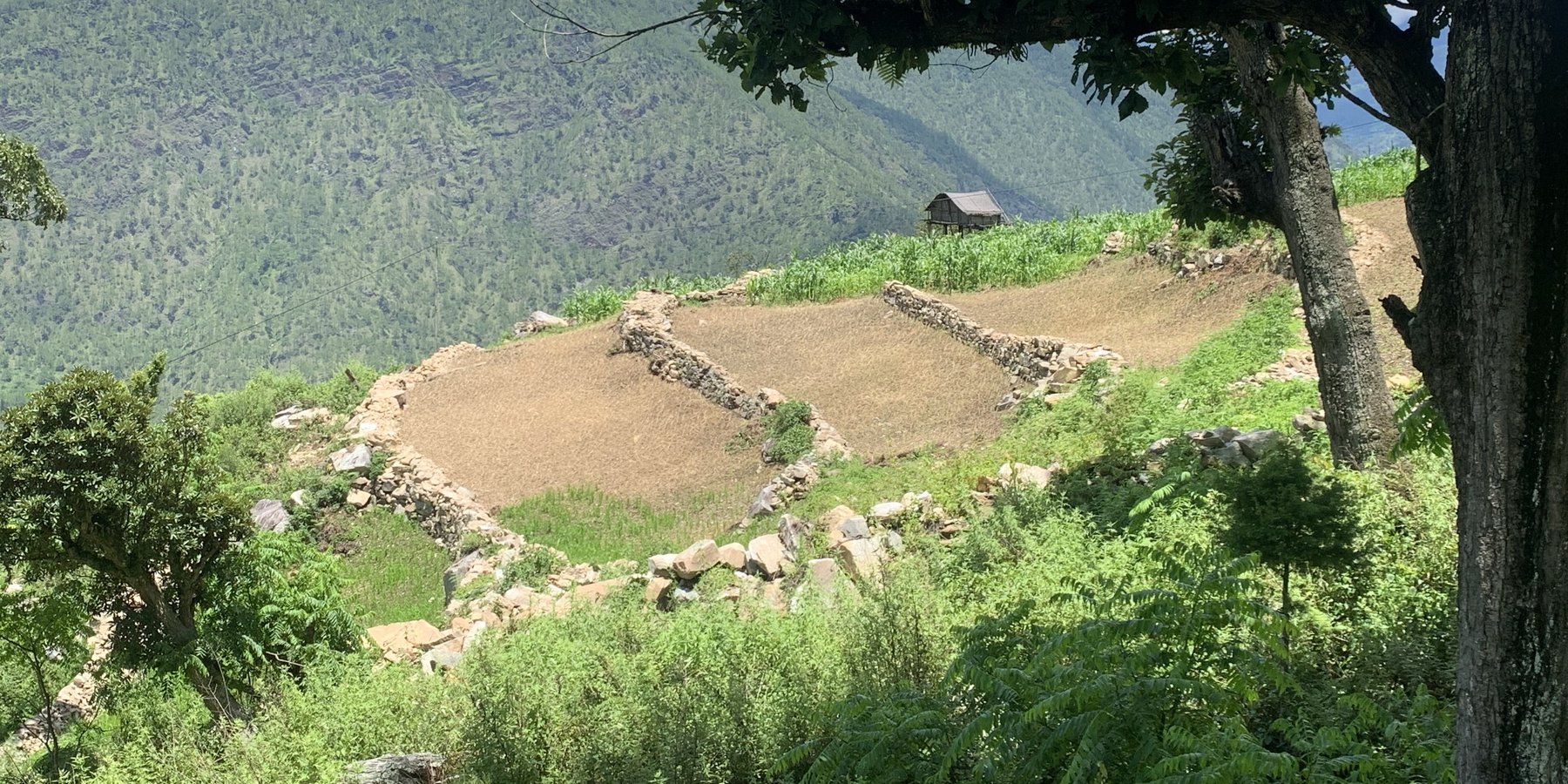
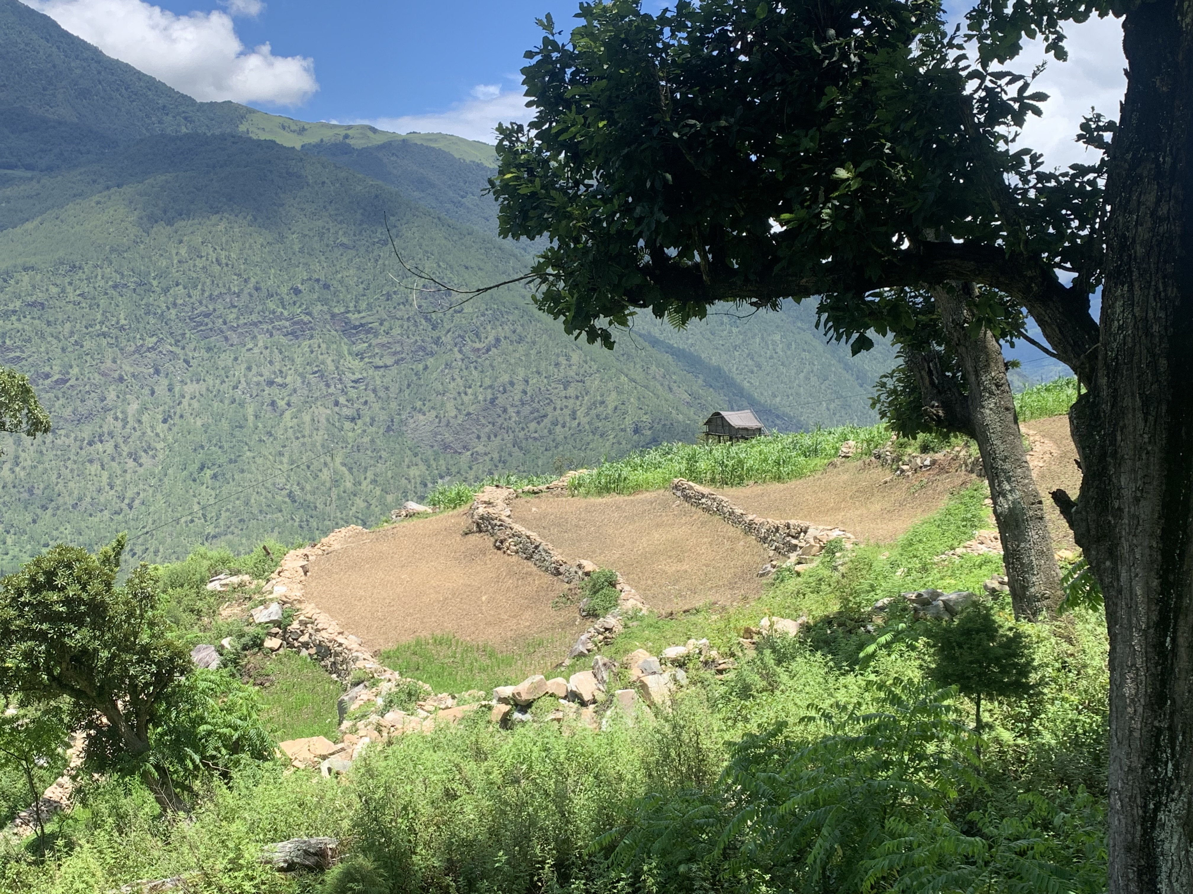
Contour stone bunding on sloping agricultural lands reduces soil erosion and conserves soil moisture in order to retain soil productivity. It is promoted /recommended on slopes where there is adequate surface stone.
2.2 Detailed description of the Technology
Description:
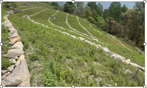
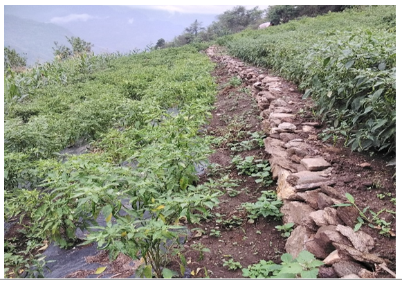
Contour stone bunds are small walls of stone that are laid out along the contour line to help reduce soil erosion, conserve soil moisture, increase soil fertility, to ease workability, increase cropping area, and ultimately ensure sustainable use of lands for enhanced food and nutrition security. This practice is recommended in fields that have plenty of surface stones (> 20%). Construction of contour stone bunds not only helps to get rid of the excess surface stones and gravel but also reduces the slope gradient through formation of partial terraces over a few years.
The stone bund is not new to Bhutan, being a mountainous country, forefathers used the technique to remove stones from the field and stabilise the land for agricultural purposes. Therefore, there were some traditional stone lines constructed in the study area.
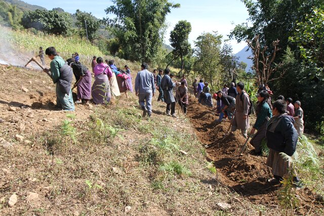
Constructing stone bund is labour intensive, therefore land users resort to a labour sharing approach where all the land users from the community come together and work on a rotational basis until every household in the community has established stone bunds.
The major activities and inputs required to establish the contour stone bund includes sensitization of beneficiaries, followed by SLM action planning, and hands-on-training. Field implementation follows this sequence: (a) determination of intervals between stone bunds, (b) demarcation of contour lines using an ‘A’ frame, (c) digging a trench of 0.1 - 0.2 m deep and 0.5 m wide to establish a foundation along the contour lines, and (d) constructing stone lines along the trenches with the larger stones at the base to set a sound foundation. A typical stone wall is 0.3 m high (1 ft) and 0.3 - 0.5 m wide, but this depends on the slope and availability of stones in the field. Contour stone bunds are commonly spaced 6 metres apart on slopes of 60%. In some cases, the fodder grass slips are also planted at the base of the stone bund for better stabilization of the bunds and fodder availability.
The major drawbacks of this SLM technology according to respondents are (a) labour demanding, (b) no immediate return, and (c) the space between piled stones harbours rodents leading to crop damage.
2.3 Photos of the Technology
Media Gallery
2.5 Country/ region/ locations where the Technology has been applied and which are covered by this assessment
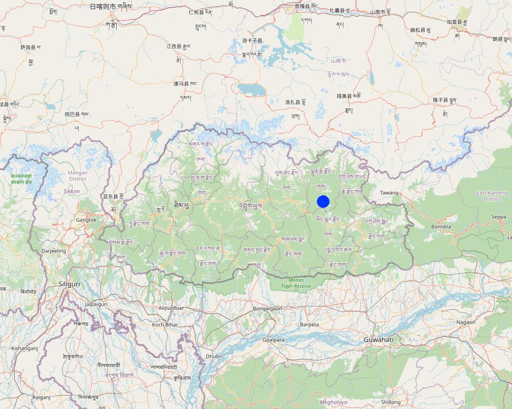
Country:
Bhutan
Region/ State/ Province:
Lhuentse Dzongkhag
Further specification of location:
Zangkhar Village, Yabi-Zangkhar Chiwog, Jaray Gewog
Specify the spread of the Technology:
- evenly spread over an area
If precise area is not known, indicate approximate area covered:
- 0.1-1 km2
Is/are the technology site(s) located in a permanently protected area?
Yes
If yes, specify:
The region where this SLM technology was implemented falls under Phrumsengla National Temperate Park. Phrumsengla National Park is a temperate park with large tracts of old-growth fir forests, its altitudes ranging from 700 metres (2,300 ft) to 4,400 metres (14,400 ft). Phrumsengla has scenic views, including forests ranging with elevations from alpine to sub-tropical. Because the soil of Phrumsengla's biomes is particularly fragile, the land is unsuitable for logging or other development
Map
×2.6 Date of implementation
Indicate year of implementation:
2015
2.7 Introduction of the Technology
Specify how the Technology was introduced:
- through projects/ external interventions
Comments (type of project, etc.):
The National Soil Service Center (NSSC), Semtokha, Thimphu initiated this activity as part of three-year (2015 to 2017) SLM project funded by Bhutan Trust Fund for Environmental Conservation (BTFEC).
3. Classification of the SLM Technology
3.1 Main purpose(s) of the Technology
- improve production
- reduce, prevent, restore land degradation
- conserve ecosystem
- adapt to climate change/ extremes and its impacts
- create beneficial economic impact
3.2 Current land use type(s) where the Technology is applied
Land use mixed within the same land unit:
Yes
Specify mixed land use (crops/ grazing/ trees):
- Agroforestry

Cropland
- Annual cropping
- Perennial (non-woody) cropping
Annual cropping - Specify crops:
- root/tuber crops - potatoes
- vegetables - leafy vegetables (salads, cabbage, spinach, other)
- Chili, cauliflower, cabbage, onion, brinjal and garlic.
- Peach, pear, fig, chayote
Number of growing seasons per year:
- 2
Specify:
Maize in summer is followed by cole crops in winter.
Is intercropping practiced?
Yes
If yes, specify which crops are intercropped:
Brinjal, beans, onion and chayote.
Is crop rotation practiced?
Yes
If yes, specify:
Maize cultivation followed by vegetables (cabbage)

Settlements, infrastructure
- Settlements, buildings
- Traffic: roads, railways
- Energy: pipelines, power lines
3.3 Has land use changed due to the implementation of the Technology?
Has land use changed due to the implementation of the Technology?
- No (Continue with question 3.4)
3.4 Water supply
Water supply for the land on which the Technology is applied:
- mixed rainfed-irrigated
3.5 SLM group to which the Technology belongs
- cross-slope measure
3.6 SLM measures comprising the Technology

vegetative measures
- V2: Grasses and perennial herbaceous plants

structural measures
- S2: Bunds, banks
Comments:
The technology also incudes vegetative measures where some land users plant fodder grass slips at the base of the stone bunds for better stabilization and fodder availability.
3.7 Main types of land degradation addressed by the Technology

soil erosion by water
- Wt: loss of topsoil/ surface erosion
- Wg: gully erosion/ gullying
- Wo: offsite degradation effects

biological degradation
- Bc: reduction of vegetation cover
- Bq: quantity/ biomass decline
- Bs: quality and species composition/ diversity decline
- Bp: increase of pests/ diseases, loss of predators

water degradation
- Ha: aridification
3.8 Prevention, reduction, or restoration of land degradation
Specify the goal of the Technology with regard to land degradation:
- reduce land degradation
- adapt to land degradation
4. Technical specifications, implementation activities, inputs, and costs
4.1 Technical drawing of the Technology
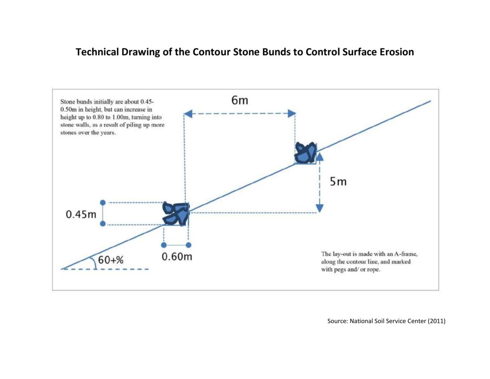
Technical specifications (related to technical drawing):
The specifications provided in the technical drawing (NSSC, 2011) may vary based on the field situation and slope of the land. Variations may be in the width of the terrace (3 m to 6 m), the height of the stone bund (0.45 m to 1m), and minimal variations are observed in the width of the stone bund (0.6 m).
Author:
National Soil Service Centre
Date:
2011
4.2 General information regarding the calculation of inputs and costs
Specify how costs and inputs were calculated:
- per Technology area
Indicate size and area unit:
3 acres
other/ national currency (specify):
Nu
If relevant, indicate exchange rate from USD to local currency (e.g. 1 USD = 79.9 Brazilian Real): 1 USD =:
80.0
Indicate average wage cost of hired labour per day:
400
4.3 Establishment activities
| Activity | Timing (season) | |
|---|---|---|
| 1. | Traditional stone bund construction | 50 years earlier |
| 2. | Sensitization, SLM action planning, and Hands-on-training | 2015 |
| 3. | Field implementation of the activity | 2015 |
| 4. | Provision of incentives (Nu. 3000 per acre) | 2015 |
| 5. | Project phase-off | 2017 |
| 6. | Scaling up of this technology through GEF-LDCF | 2022 |
Comments:
Traditionally stone bunds were constructed by forefathers during land preparation on the slopes. The stones were piled at the contour lines to make the soil workable and improve the gradient of the land.
4.4 Costs and inputs needed for establishment
| Specify input | Unit | Quantity | Costs per Unit | Total costs per input | % of costs borne by land users | |
|---|---|---|---|---|---|---|
| Labour | Labour | Person/day | 49.0 | 400.0 | 19600.0 | 100.0 |
| Other | Project incentive | Per hectare | 1.0 | 6420.0 | 6420.0 | |
| Total costs for establishment of the Technology | 26020.0 | |||||
| Total costs for establishment of the Technology in USD | 325.25 | |||||
Comments:
The costs and inputs needed for stone bund establishment are calculated for 1 hectare of land.
4.7 Most important factors affecting the costs
Describe the most determinate factors affecting the costs:
The most important factor affecting the cost is labor.
5. Natural and human environment
5.1 Climate
Annual rainfall
- < 250 mm
- 251-500 mm
- 501-750 mm
- 751-1,000 mm
- 1,001-1,500 mm
- 1,501-2,000 mm
- 2,001-3,000 mm
- 3,001-4,000 mm
- > 4,000 mm
Specify average annual rainfall (if known), in mm:
1250.00
Specifications/ comments on rainfall:
The rainfall received in the region may vary from 1000 to 1500 mm.
The rainfall data of the Gewog is not available. The area shares a border with the Medtsho Gewog and has similar agroecological zones. The data provided is for Medtsho Gewog.
Indicate the name of the reference meteorological station considered:
Website, Lhuentse Dzongkhag Administration
Agro-climatic zone
- sub-humid
The Gewog falls under dry sub-tropical to warm temperate region (1500 to 2400 meters above sea level) from the six agroecological zones of Bhutan. It is characterized by extreme cold in winter and moderate in summer, humid and foggy.
5.2 Topography
Slopes on average:
- flat (0-2%)
- gentle (3-5%)
- moderate (6-10%)
- rolling (11-15%)
- hilly (16-30%)
- steep (31-60%)
- very steep (>60%)
Landforms:
- plateau/plains
- ridges
- mountain slopes
- hill slopes
- footslopes
- valley floors
Altitudinal zone:
- 0-100 m a.s.l.
- 101-500 m a.s.l.
- 501-1,000 m a.s.l.
- 1,001-1,500 m a.s.l.
- 1,501-2,000 m a.s.l.
- 2,001-2,500 m a.s.l.
- 2,501-3,000 m a.s.l.
- 3,001-4,000 m a.s.l.
- > 4,000 m a.s.l.
Indicate if the Technology is specifically applied in:
- convex situations
5.3 Soils
Soil depth on average:
- very shallow (0-20 cm)
- shallow (21-50 cm)
- moderately deep (51-80 cm)
- deep (81-120 cm)
- very deep (> 120 cm)
Soil texture (topsoil):
- coarse/ light (sandy)
Soil texture (> 20 cm below surface):
- coarse/ light (sandy)
Topsoil organic matter:
- low (<1%)
If available, attach full soil description or specify the available information, e.g. soil type, soil PH/ acidity, Cation Exchange Capacity, nitrogen, salinity etc.
Moisture content 3.10%, organic matter 7.15%, Organic carbon 4.15%, pH 6.79, electrical conductivity 209.20 µs/cm, nitrogen 0.21%, phosphorus 1.00 ppm, Potassium 121.40 mg/100ml, texture loamy sand.
The soil analysis was conducted at the Science Laboratory of College of Natural Resources, Royal University of Bhutan, Lobesa, Punakha.
5.4 Water availability and quality
Availability of surface water:
medium
Water quality (untreated):
good drinking water
Water quality refers to:
ground water
Is water salinity a problem?
No
Is flooding of the area occurring?
No
5.5 Biodiversity
Species diversity:
- high
Habitat diversity:
- high
Comments and further specifications on biodiversity:
The area is rich in species diversity as it has pockets of microclimate ensuring habitat diversity.
5.6 Characteristics of land users applying the Technology
Sedentary or nomadic:
- Sedentary
Market orientation of production system:
- mixed (subsistence/ commercial)
Off-farm income:
- less than 10% of all income
Relative level of wealth:
- average
Individuals or groups:
- individual/ household
Level of mechanization:
- manual work
- mechanized/ motorized
Gender:
- women
Age of land users:
- middle-aged
Indicate other relevant characteristics of the land users:
There are 11 Household members of which only the land user and her mother (86 years old) stay at home. Nine household members have migrated to the city for better opportunities.
5.7 Average area of land used by land users applying the Technology
- < 0.5 ha
- 0.5-1 ha
- 1-2 ha
- 2-5 ha
- 5-15 ha
- 15-50 ha
- 50-100 ha
- 100-500 ha
- 500-1,000 ha
- 1,000-10,000 ha
- > 10,000 ha
Is this considered small-, medium- or large-scale (referring to local context)?
- large-scale
Comments:
The land user has 4 acres of land of which the technology is applied in 3 acres. The average land holding in Bhutan is 3.4 acres per household in 2021. Therefore, more than 3.4 acres are characterized as large-scale in the Bhutanese context.
5.8 Land ownership, land use rights, and water use rights
- Family
Land use rights:
- individual
Water use rights:
- open access (unorganized)
Are land use rights based on a traditional legal system?
Yes
5.9 Access to services and infrastructure
health:
- poor
- moderate
- good
education:
- poor
- moderate
- good
technical assistance:
- poor
- moderate
- good
employment (e.g. off-farm):
- poor
- moderate
- good
markets:
- poor
- moderate
- good
energy:
- poor
- moderate
- good
roads and transport:
- poor
- moderate
- good
drinking water and sanitation:
- poor
- moderate
- good
financial services:
- poor
- moderate
- good
6. Impacts and concluding statements
6.1 On-site impacts the Technology has shown
Socio-economic impacts
Production
crop production
Comments/ specify:
The cultivation of potatoes increased due to an increase in the cultivable area as the stones are removed.
crop quality
Comments/ specify:
Crops appear greener and healthier due prevention of soil erosion as the topsoil is retained. Maize leaves were dark green and potatoes were bigger.
risk of production failure
Comments/ specify:
Due to the removal of stones from the soil, it is suitable for diverse crop growth (deep-rooted and shallow). Therefore, the land user can cultivate diverse crops throughout the year. Crop diversity and increased growing season will ensure land user with stable household income even if one crop fails.
product diversity
Comments/ specify:
The technology reduces workload (mechanization) and increases cultivable area leading to the cultivation of diverse crops for market purposes.
production area
Comments/ specify:
Increased due to the removal of stones from the land.
Income and costs
expenses on agricultural inputs
Comments/ specify:
Expenses on agriculture input are reduced. For example, with the use of a power tiller which costs Nu. 1500 per day, it takes 2 days to complete ploughing. If it is done by oxen then it takes 8 days and Nu. 400 is paid as a labour charge per day. The total amount required using the power tiller is Nu. 3000 and using oxen is Nu. 3200 with an additional cost of food for the labourers.
farm income
Comments/ specify:
Previously the land user was not able to meet the demand for maize as a feed for the cattle. With the introduction of stone bunding and increased production, the land user can meet her domestic demand for maize and additionally sell processed maize alcohol as a source of farm income.
diversity of income sources
Comments/ specify:
There is an increased diversity of income sources as the land user can grow different crops throughout the year and also sell some processed products.
workload
Comments/ specify:
Reduced work load due to farm mechanization. The removal of stone from field had eased workability, lesser wear and tear of farm tools.
Socio-cultural impacts
food security/ self-sufficiency
Comments/ specify:
With the increase in cultivable areas, technology has ensured food self-sufficiency and generated income to meet other household demands for food.
recreational opportunities
Comments/ specify:
Reduced workload is directly related to an increase in the available time for recreational opportunities.
national institutions
Comments/ specify:
Support provided by the NSSC and land users' active participation in the implementation of the technology enabled the national agency to have a better understanding of the land users. Labour sharing enabled the community to work together to achieve a common goal which improved collaboration among the community members.
SLM/ land degradation knowledge
Comments/ specify:
Awareness was created during the introduction of the technology by SLM specialists. Further, the field observation on the neighbours' fields who have already established stone bunds has led to 90% of the population knowing about the stone bunding in the locality.
conflict mitigation
Comments/ specify:
Human-wildlife conflict was reduced as wild boars were not able to climb the stone bund. Although other wild animal such as procupine continued to cause harm to the crop.
situation of socially and economically disadvantaged groups
Comments/ specify:
The technology improved soil quality leading to improved production and increased household income.
Ecological impacts
Soil
soil moisture
Comments/ specify:
The stone bund holds irrigation water preventing surface runoff. Further, the gradual labelling of the land increases soil moisture retention capacity.
soil cover
Comments/ specify:
Increased due to crop diversification and year-round cultivation.
soil loss
Comments/ specify:
Soil erosion and surface runoff is reduced leading to decreased soil loss.
soil accumulation
Comments/ specify:
Eroded soil is accumulated at bunds.
soil organic matter/ below ground C
Comments/ specify:
Soil organic matter is decreased at the upper part of the terrace and increased at the lower part of the terrace due to runoff from the slopes.
Biodiversity: vegetation, animals
Vegetation cover
Comments/ specify:
Increased with the practice of year-round cultivation.
plant diversity
Comments/ specify:
The technology increased suitability of the soil for diverse crops increasing plant diversity.
pest/ disease control
Comments/ specify:
The better crop stand resists pest and diseases attacks on crops. To some extend, the stone bunds keep the wild boars away.
Climate and disaster risk reduction
landslides/ debris flows
Comments/ specify:
Reduced surface runoff leads to decreased landslides or debris flow.
Specify assessment of on-site impacts (measurements):
The impact percentage given in this section is a mixture of farmer and professional estimates.
6.2 Off-site impacts the Technology has shown
Specify assessment of off-site impacts (measurements):
No off-site impact of the technology is expected or measurable on this small scattered scale.
6.3 Exposure and sensitivity of the Technology to gradual climate change and climate-related extremes/ disasters (as perceived by land users)
Gradual climate change
Gradual climate change
| Season | increase or decrease | How does the Technology cope with it? | |
|---|---|---|---|
| annual rainfall | increase | not well |
Comments:
The technology does not cope well with increased annual rainfall as it loosens the foundation soil on which the stone wall is built leading to the collapsing of the stone wall.
6.4 Cost-benefit analysis
How do the benefits compare with the establishment costs (from land users’ perspective)?
Short-term returns:
positive
Long-term returns:
positive
How do the benefits compare with the maintenance/ recurrent costs (from land users' perspective)?
Short-term returns:
very positive
Long-term returns:
very positive
Comments:
The benefits compared with the establishment costs for the short term are positive due to the subsidy provided.
6.5 Adoption of the Technology
- > 50%
If available, quantify (no. of households and/ or area covered):
Total of 33 households adopted stone bunds technology.
Of all those who have adopted the Technology, how many did so spontaneously, i.e. without receiving any material incentives/ payments?
- 0-10%
Comments:
All the households received incentive in the form of cash and machinery.
6.6 Adaptation
Has the Technology been modified recently to adapt to changing conditions?
No
6.7 Strengths/ advantages/ opportunities of the Technology
| Strengths/ advantages/ opportunities in the land user’s view |
|---|
| Sloping land is challenged by soil erosion and it has a poor ability to retain water. This challenge was alleviated by stone bunding as it significantly reduced soil degradation. |
| The land user shared that there is an increased cultivable area after the implementation of the technology. Bigger stones were excavated and piled as stone bunds increasing the total area for cultivation. |
| The technology eased farming, as agronomic practices such as tilling became efficient due to the use of power tillers. Soil depth was increased leading to ease in weeding, bed making and other management practices. |
| Stone walls prevented wild boar from entering the field reducing crop loss. Therefore, the farmers need not guard the field from wild boar. |
| Increased cultivable area and easy working conditions of the soil lead to increased production, and improved livelihood of the farm household. |
| Strengths/ advantages/ opportunities in the compiler’s or other key resource person’s view |
|---|
| The technology contributed to reducing rural-urban migration and generated employment. Stone bunding indirectly helped the farming community to engage in agricultural activities and stay back in the village rather than going out to the city in search of employment. |
| Prevent natural disasters. The Gewog is located in the steep slopes and there is a risk of landslides leading to loss of agricultural land, property, and life. Stone bunding prevents surface runoff which could aggravate and lead to land slides. |
| Once the stone and boulders are removed and piled along contour line, it improves workability on the farm. |
6.8 Weaknesses/ disadvantages/ risks of the Technology and ways of overcoming them
| Weaknesses/ disadvantages/ risks in the land user’s view | How can they be overcome? |
|---|---|
| Construction of stone bunds is a laboursome and has no direct benefit to the land users. | Practice labour sharing working modality. |
| If stone bunds were not constructed properly, it could be easily damaged by cattle, washed or collapsed by heavy rainfall. | Proper piling of stones during the stone bund construction. |
| Weaknesses/ disadvantages/ risks in the compiler’s or other key resource person’s view | How can they be overcome? |
|---|---|
| Some sort of incentives is required to scale out the adoption of technology as its requires huge labour and time with no immediate benefits. | Incentive of Nu 3000 tied with construction of 1 ac of stone bunds |
7. References and links
7.1 Methods/ sources of information
- field visits, field surveys
Three field visits was conducted
- interviews with land users
Randomly picked land user from the community for documentation. One land user was interviewed.
When were the data compiled (in the field)?
22/07/2023
7.2 References to available publications
Title, author, year, ISBN:
NSSC. (2011). Bhutan catalogue of soil and water conservation approaches and technologies. National Soil Service Center (NSSC), Department of Agriculture, Ministry of Agriculture and Forests, Royal Government of Bhutan, Thimphu
Available from where? Costs?
Book and soft copy from https://www.wocat.net/documents/140/Bhutan_catalogue_of_SLM_Technologies_and_Approaches.pdf
7.3 Links to relevant online information
Title/ description:
Sustainable Land Management for improved land productivity & community livelihood in Thangrong
URL:
https://www.youtube.com/watch?v=-XS-qFv2dYQ
Links and modules
Expand all Collapse allLinks
Community Mobilization for SLM Interventions [Bhutan]
Community mobilization in implementing sustainable land management technologies is indispensable in engaging the community to identify their priorities, resources, needs and solutions. It ultimately promotes bottom-up participation and fosters accountability.
- Compiler: Nima Dolma Tamang
Modules
No modules