River training dam [Tajikistan]
- Creation:
- Update:
- Compiler: Margaux Tharin
- Editor: –
- Reviewers: Alexandra Gavilano, Alvin Chandra, Rima Mekdaschi Studer
Дамбаи Обпартоб
technologies_698 - Tajikistan
View sections
Expand all Collapse all1. General information
1.2 Contact details of resource persons and institutions involved in the assessment and documentation of the Technology
Key resource person(s)
land user:
Name of project which facilitated the documentation/ evaluation of the Technology (if relevant)
Book project: where people and their land are safer - A Compendium of Good Practices in Disaster Risk Reduction (DRR) (where people and their land are safer)Name of the institution(s) which facilitated the documentation/ evaluation of the Technology (if relevant)
CARITAS (Switzerland) - Switzerland1.3 Conditions regarding the use of data documented through WOCAT
The compiler and key resource person(s) accept the conditions regarding the use of data documented through WOCAT:
Yes
1.4 Declaration on sustainability of the described Technology
Is the Technology described here problematic with regard to land degradation, so that it cannot be declared a sustainable land management technology?
No
2. Description of the SLM Technology
2.1 Short description of the Technology
Definition of the Technology:
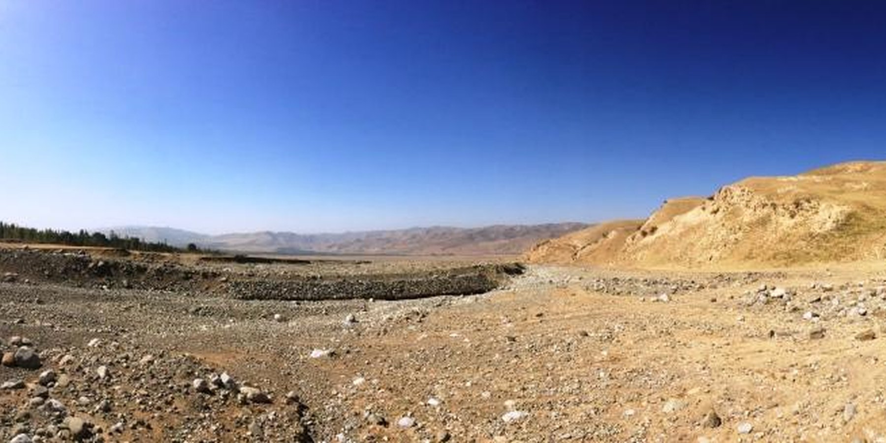
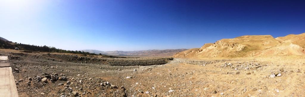
The river training dam is a disaster mitigation structure protecting downstream areas from flash floods and mudflows. It consists of a channel dug and wire net gabions built to train the river and is hence cheap to establish and maintain. There is a substantial community contribution as labour is an important part of the input costs. The dam enables the rehabilitation of unproductive land in the downstream catchment areas, reduction of crop pests, increase in crop diversity and land productivity, and an overall improvement of livelihoods for downstream communities through reduced vulnerability to disasters.
2.2 Detailed description of the Technology
Description:
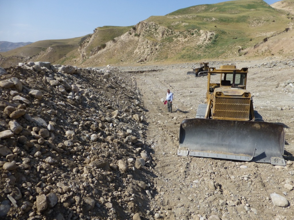
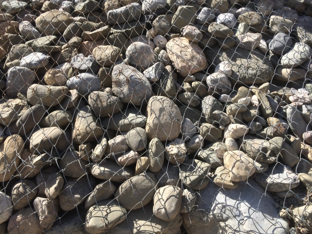
The river training dam is a disaster mitigation structure constructed in the middle zone of the watershed of Obishur (Southern Tajikistan), at 1400 metres above sea level. It is diverting the water from the river fan naturally flowing through Kulchashma village into a different direction and river outlet (Yakhsu river). The dike is a simple structure consisting of a 400m-long and 4m-high channel dug by bulldozer consolidated by a 60m-long and 3m-wide gabion protecting a sharp curve of the river. The material needed is limited to stones and wire net, and the construction as well as maintenance costs are hence low and don't need a too high amount of labour, provided by the communities as in-kind contribution. The structure is built to resist a pressure of up to 72 m3/sec. Given the annual frequency and strength of the local floods, the Kulchashma river training dam has an estimated life expectancy of 30 years. The land users proposed to establish the dam in order to protect the 250 households and 270 ha of land downstream being regularly affected by the floods. In particular, people, houses, roads and other infrastructure, crop and pasture land as well as animals and other assets were highly exposed to the risk of flood. The agricultural production, constituting the main part of people’s income was hindered by the regular occurrence of disasters. The establishment of the river training dam resulted in the rehabilitation of unproductive land in the river fan and its use as pasture and arable land which the community mainly uses for agroforestry. The occurrence of crop pests decreased, the crop diversity was increased, the crop and land productivity improved, thereby enhancing the land users’ food security and overall income. The dam also allowed vulnerable community members to access land and build houses. The construction of buildings behind the dam is however risky and communities tend to forget or ignore that a risk of failure of the dam persists, and that its life expectancy is limited. But first of all, the personal safety of the community members is now improved and they are happy to be able to sleep without the fear of regular floods.
2.3 Photos of the Technology
Media Gallery
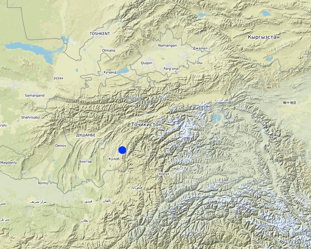
2.5 Country/ region/ locations where the Technology has been applied and which are covered by this assessment
Country:
Tajikistan
Region/ State/ Province:
Khatlon Region, Muminabad District
Further specification of location:
Kulchashma Jamoat, Kulchashma village
Specify the spread of the Technology:
- applied at specific points/ concentrated on a small area
Comments:
water diversion and drainage
Map
×2.6 Date of implementation
Indicate year of implementation:
2014
2.7 Introduction of the Technology
Specify how the Technology was introduced:
- through land users' innovation
Comments (type of project, etc.):
The adoption of the technology was proposed by the land users.
3. Classification of the SLM Technology
3.1 Main purpose(s) of the Technology
- improve production
- reduce, prevent, restore land degradation
- protect a watershed/ downstream areas – in combination with other Technologies
- reduce risk of disasters
- create beneficial economic impact
3.2 Current land use type(s) where the Technology is applied

Grazing land
Extensive grazing:
- Semi-nomadic pastoralism
3.4 Water supply
Water supply for the land on which the Technology is applied:
- mixed rainfed-irrigated
Comments:
Irrigation - main irrigation channels also received water diverted by the dam.
3.5 SLM group to which the Technology belongs
- water diversion and drainage
3.6 SLM measures comprising the Technology

structural measures
- S3: Graded ditches, channels, waterways
- S5: Dams, pans, ponds
3.7 Main types of land degradation addressed by the Technology

soil erosion by water
- Wt: loss of topsoil/ surface erosion
- Wg: gully erosion/ gullying
- Wr: riverbank erosion
- Wo: offsite degradation effects

biological degradation
- Bc: reduction of vegetation cover
- Bh: loss of habitats
- Bq: quantity/ biomass decline
- Bl: loss of soil life
- Bp: increase of pests/ diseases, loss of predators

water degradation
- Hs: change in quantity of surface water
- Hp: decline of surface water quality
- Hq: decline of groundwater quality
Comments:
Improvement of groundwater quality is not the focus of the project but the technology has an impact on this type of natural degradation process.
3.8 Prevention, reduction, or restoration of land degradation
Specify the goal of the Technology with regard to land degradation:
- reduce land degradation
- restore/ rehabilitate severely degraded land
Comments:
Flood sediments are diverted by the dam and its accumulation in the lower zone of the watersheds is prevented, thereby allowing the rehabilitation of arable land downstream.
4. Technical specifications, implementation activities, inputs, and costs
4.1 Technical drawing of the Technology
Technical specifications (related to technical drawing):
Specify how costs and inputs were calculated:
per Technology unit
Specify unit:
Dam
Specify dimensions of unit (if relevant):
400m-long dug channel and 60m-long gabion
Specify currency used for cost calculations:
USD
Author:
Sady Odinashoev
Date:
01/08/2013
4.2 General information regarding the calculation of inputs and costs
Specify how costs and inputs were calculated:
- per Technology unit
Specify unit:
Dam
Specify dimensions of unit (if relevant):
400m-long dug channel and 60m-long gabion
Specify currency used for cost calculations:
- USD
4.3 Establishment activities
| Activity | Timing (season) | |
|---|---|---|
| 1. | 400m-long channel digging (bulldozer) | August-October |
| 2. | Stone collection | October (10 days) |
| 3. | Construction of gabions | November (15 days) |
Comments:
Establishment activities to be completed before the cold and snow/rain season.
4.4 Costs and inputs needed for establishment
| Specify input | Unit | Quantity | Costs per Unit | Total costs per input | % of costs borne by land users | |
|---|---|---|---|---|---|---|
| Labour | Construction of wire net gabions | person-hours | 1400.0 | 1.5 | 2100.0 | 100.0 |
| Labour | Bulldozer driving | person-hours | 150.0 | 1.5 | 225.0 | |
| Equipment | Bulldozer rent | day | 15.0 | 63.0 | 945.0 | |
| Equipment | Fuel for bulldozer | litre | 2250.0 | 1.35 | 3037.5 | |
| Equipment | Diesel oil for bulldozer | litre | 68.0 | 2.13 | 144.84 | |
| Equipment | Spindle oil for bulldozer | litre | 45.0 | 2.0 | 90.0 | |
| Construction material | wire net (diametre 4mm) | m2 | 625.0 | 1.6 | 1000.0 | |
| Construction material | wire (diametre 3mm) | kg | 26.0 | 1.6 | 41.6 | |
| Other | Gearbox oil for bulldozer | litre | 22.0 | 2.5 | 55.0 | |
| Other | Solid oil for bulldozer | litre | 22.0 | 3.0 | 66.0 | |
| Other | Gas for bulldozer | litre | 22.0 | 1.4 | 30.8 | |
| Total costs for establishment of the Technology | 7735.74 | |||||
| Total costs for establishment of the Technology in USD | 7735.74 | |||||
If land user bore less than 100% of costs, indicate who covered the remaining costs:
Rent of bulldozer + bulldozer driving covered by local district government. All other costs covered by project.
Comments:
Cost-sharing for establishment and maintenance activities is agreed upon when determining the design and implementation of the dam as part of the project conditions.
4.5 Maintenance/ recurrent activities
| Activity | Timing/ frequency | |
|---|---|---|
| 1. | Fixing of wire net gabions | March, annually |
Comments:
Maintenance activities to be conducted before peak rain/snowmelt/flood season.
4.6 Costs and inputs needed for maintenance/ recurrent activities (per year)
| Specify input | Unit | Quantity | Costs per Unit | Total costs per input | % of costs borne by land users | |
|---|---|---|---|---|---|---|
| Labour | Fixing wire net (by Self Help Group) | hour | 40.0 | 0.8 | 32.0 | 100.0 |
| Construction material | wire net | kg | 7.0 | 1.0 | 7.0 | 100.0 |
| Total costs for maintenance of the Technology | 39.0 | |||||
| Total costs for maintenance of the Technology in USD | 39.0 | |||||
Comments:
All maintenance costs covered by land users.
4.7 Most important factors affecting the costs
Describe the most determinate factors affecting the costs:
- Geography (steep hills to dig a diverting channel increases the establishment costs)
- Geology (quality/type of soil affects the time needed for digging)
5. Natural and human environment
5.1 Climate
Annual rainfall
- < 250 mm
- 251-500 mm
- 501-750 mm
- 751-1,000 mm
- 1,001-1,500 mm
- 1,501-2,000 mm
- 2,001-3,000 mm
- 3,001-4,000 mm
- > 4,000 mm
Specifications/ comments on rainfall:
Varies very much from year to year.
Indicate the name of the reference meteorological station considered:
Muminabad meteo station (1200 m a.s.l.)
Agro-climatic zone
- semi-arid
Average temperatures:
Spring:10-32°C
Summer: 20-35°C
Autumn: 10-32°C
Winter: -5-+5°C
Average yearly temperature: 11.1°C
5.2 Topography
Slopes on average:
- flat (0-2%)
- gentle (3-5%)
- moderate (6-10%)
- rolling (11-15%)
- hilly (16-30%)
- steep (31-60%)
- very steep (>60%)
Landforms:
- plateau/plains
- ridges
- mountain slopes
- hill slopes
- footslopes
- valley floors
Altitudinal zone:
- 0-100 m a.s.l.
- 101-500 m a.s.l.
- 501-1,000 m a.s.l.
- 1,001-1,500 m a.s.l.
- 1,501-2,000 m a.s.l.
- 2,001-2,500 m a.s.l.
- 2,501-3,000 m a.s.l.
- 3,001-4,000 m a.s.l.
- > 4,000 m a.s.l.
Indicate if the Technology is specifically applied in:
- concave situations
5.3 Soils
Soil depth on average:
- very shallow (0-20 cm)
- shallow (21-50 cm)
- moderately deep (51-80 cm)
- deep (81-120 cm)
- very deep (> 120 cm)
Soil texture (topsoil):
- coarse/ light (sandy)
- medium (loamy, silty)
Soil texture (> 20 cm below surface):
- coarse/ light (sandy)
- medium (loamy, silty)
Topsoil organic matter:
- low (<1%)
If available, attach full soil description or specify the available information, e.g. soil type, soil PH/ acidity, Cation Exchange Capacity, nitrogen, salinity etc.
On southern (sunny) side of the hills, loess type of soil. On northern (shady) side of the hills, humus type of soil
5.4 Water availability and quality
Ground water table:
> 50 m
Availability of surface water:
excess
Water quality (untreated):
good drinking water
Is water salinity a problem?
No
Is flooding of the area occurring?
Yes
Regularity:
episodically
Comments and further specifications on water quality and quantity:
Seasonal floods/high runoff in spring time, when heavy rain coincides with snowmelt.
5.5 Biodiversity
Species diversity:
- medium
Habitat diversity:
- medium
5.6 Characteristics of land users applying the Technology
Sedentary or nomadic:
- Sedentary
Market orientation of production system:
- subsistence (self-supply)
Off-farm income:
- 10-50% of all income
Relative level of wealth:
- average
Individuals or groups:
- individual/ household
Level of mechanization:
- manual work
- mechanized/ motorized
Gender:
- women
- men
Age of land users:
- youth
- middle-aged
5.7 Average area of land used by land users applying the Technology
- < 0.5 ha
- 0.5-1 ha
- 1-2 ha
- 2-5 ha
- 5-15 ha
- 15-50 ha
- 50-100 ha
- 100-500 ha
- 500-1,000 ha
- 1,000-10,000 ha
- > 10,000 ha
Is this considered small-, medium- or large-scale (referring to local context)?
- medium-scale
5.8 Land ownership, land use rights, and water use rights
Land ownership:
- state
Land use rights:
- leased
Water use rights:
- communal (organized)
5.9 Access to services and infrastructure
health:
- poor
- moderate
- good
education:
- poor
- moderate
- good
technical assistance:
- poor
- moderate
- good
employment (e.g. off-farm):
- poor
- moderate
- good
markets:
- poor
- moderate
- good
energy:
- poor
- moderate
- good
roads and transport:
- poor
- moderate
- good
drinking water and sanitation:
- poor
- moderate
- good
financial services:
- poor
- moderate
- good
6. Impacts and concluding statements
6.1 On-site impacts the Technology has shown
Socio-economic impacts
Production
crop production
Quantity before SLM:
No production
Quantity after SLM:
Self-use + surplus sold on market
Comments/ specify:
6000 kg onions/ ha
crop quality
Comments/ specify:
35-40% increase
fodder production
Comments/ specify:
On average 50% increase of fodder. Additionally, fodder crop seeds (lucerne) can be sold; increases land users' income.
fodder quality
animal production
risk of production failure
Comments/ specify:
One of the main and most important impact
product diversity
production area
Comments/ specify:
25-30% increase in production area in lowlands (downstream) through rehabilitation of unproductive land which was previously regularly flooded and covered by sediments.
land management
Comments/ specify:
Trees newly planted are used for riverbed protection and fuelwood production
Water availability and quality
drinking water availability
Comments/ specify:
Floods do not contaminate spring drinking waters with sediments
drinking water quality
irrigation water availability
Comments/ specify:
Irrigation channel not destroyed by annual floods anymore.
Income and costs
expenses on agricultural inputs
Comments/ specify:
Pests decreased.
farm income
Comments/ specify:
Through rehabilitation of unproductive land in river fan.
diversity of income sources
Other socio-economic impacts
orchards
Socio-cultural impacts
food security/ self-sufficiency
Comments/ specify:
Cultivation of wheat plots and vegetables for self-use and sale
health situation
land use/ water rights
Comments/ specify:
Previously unused land in the river fan is now registered as pasture land with a land certificate for the use of the community, and new houses where also built on this land.
recreational opportunities
community institutions
Comments/ specify:
Taxes can be collected with the registration and certification of pasture land and with the authorisation of house construction.
SLM/ land degradation knowledge
situation of socially and economically disadvantaged groups
Comments/ specify:
With dam constructed, economically disadvantaged people have space for building a house on the rehabilitated land.
Ecological impacts
Water cycle/ runoff
surface runoff
excess water drainage
Soil
soil cover
soil loss
soil accumulation
nutrient cycling/ recharge
soil organic matter/ below ground C
Biodiversity: vegetation, animals
Vegetation cover
plant diversity
pest/ disease control
Climate and disaster risk reduction
flood impacts
landslides/ debris flows
6.2 Off-site impacts the Technology has shown
reliable and stable stream flows in dry season
downstream flooding
downstream siltation
damage on neighbours' fields
damage on public/ private infrastructure
Specify assessment of off-site impacts (measurements):
In the last three years no flood affected the downstream village. 330ha of land situated downstream of the dam has been rehabilitated, cleaned from big stones, and used fully as pasture. No sediment flood affected the use of this rehabilitated land.
6.3 Exposure and sensitivity of the Technology to gradual climate change and climate-related extremes/ disasters (as perceived by land users)
Gradual climate change
Gradual climate change
| Season | increase or decrease | How does the Technology cope with it? | |
|---|---|---|---|
| annual rainfall | increase | well | |
| seasonal rainfall | spring | increase | well |
Climate-related extremes (disasters)
Hydrological disasters
| How does the Technology cope with it? | |
|---|---|
| general (river) flood | very well |
| flash flood | very well |
6.4 Cost-benefit analysis
How do the benefits compare with the establishment costs (from land users’ perspective)?
Short-term returns:
very positive
How do the benefits compare with the maintenance/ recurrent costs (from land users' perspective)?
Short-term returns:
very positive
Comments:
From the land-user perspective, the benefit assessment of the establishment costs could only be done in relation to the land-users' contribution (i.e. 10% of establishment costs in cash or USD 600 , plus labour).
Because the dam was constructed less than 10 years ago, the long-terms returns cannot be assessed yet.
6.5 Adoption of the Technology
- > 50%
If available, quantify (no. of households and/ or area covered):
250 households and 270 ha covered, i.e. 50% of Kulchashma village's population.
Of all those who have adopted the Technology, how many did so spontaneously, i.e. without receiving any material incentives/ payments?
- 0-10%
Comments:
This low percentage is explained by the fact that a structural measure like a dam construction is a big collective investment and can only be initiated as a group with coordination.
6.6 Adaptation
Has the Technology been modified recently to adapt to changing conditions?
No
6.7 Strengths/ advantages/ opportunities of the Technology
| Strengths/ advantages/ opportunities in the land user’s view |
|---|
| The construction and maintenance of a river training dam prevents further land degradation caused by floods, allows the rehabilitation of unused land to create new pastures, and above all increases people's and livestock's safety. |
| Strengths/ advantages/ opportunities in the compiler’s or other key resource person’s view |
|---|
| General improvement of life quality, including life safety and opportunities to protect assets and improve livelihoods. |
6.8 Weaknesses/ disadvantages/ risks of the Technology and ways of overcoming them
| Weaknesses/ disadvantages/ risks in the land user’s view | How can they be overcome? |
|---|---|
| None | n/a |
| Weaknesses/ disadvantages/ risks in the compiler’s or other key resource person’s view | How can they be overcome? |
|---|---|
| Downstream communities feel safe behind the dam and tend to ignore the risk of failure in extreme conditions (beyond the coping capacity of the dam). As a consequence, people build houses in places still at risk in the river fan. | Strengthened governance (no authorisation of construction in the river fan/behind the dam in the risk zone). |
7. References and links
7.1 Methods/ sources of information
- interviews with land users
5 land users
- interviews with SLM specialists/ experts
1
When were the data compiled (in the field)?
11/10/2016
Links and modules
Expand all Collapse allLinks
No links
Modules
No modules