River training dam [ប្រទេសតាហ្ស៊ីគីស្ថាន]
- ការបង្កើត៖
- បច្ចុប្បន្នភាព
- អ្នកចងក្រង៖ Margaux Tharin
- អ្នកកែសម្រួល៖ –
- អ្នកត្រួតពិនិត្យច្រើនទៀត៖ Alexandra Gavilano, Alvin Chandra, Rima Mekdaschi Studer
Дамбаи Обпартоб
technologies_698 - ប្រទេសតាហ្ស៊ីគីស្ថាន
ពិនិត្យមើលគ្រប់ផ្នែក
ពង្រីកមើលទាំងអស់ បង្រួមទាំងអស់1. ព័ត៌មានទូទៅ
1.2 ព័ត៌មានលម្អិតពីបុគ្គលសំខាន់ៗ និងស្ថាប័នដែលចូលរួមក្នុងការវាយតម្លៃ និងចងក្រងឯកសារនៃបច្ចេកទេស
បុគ្គលសំខាន់ម្នាក់ (ច្រើននាក់)
អ្នកប្រើប្រាស់ដី:
ឈ្មោះគម្រោងដែលបានចងក្រងឯកសារ/ វាយតម្លៃលើបច្ចេកទេស (បើទាក់ទង)
Book project: where people and their land are safer - A Compendium of Good Practices in Disaster Risk Reduction (DRR) (where people and their land are safer)ឈ្មោះអង្គភាពមួយ (ច្រើន) ដែលបានចងក្រងឯកសារ/ វាយតម្លៃបច្ចេកទេស (បើទាក់ទង)
CARITAS (Switzerland) - ប្រទេសស្វ៊ីស1.3 លក្ខខណ្ឌទាក់ទងទៅនឹងការប្រើប្រាស់ទិន្នន័យដែលបានចងក្រងតាមរយៈ វ៉ូខេត
អ្នកចងក្រង និង(បុគ្គលសំខាន់ៗ)យល់ព្រមទទួលយកនូវលក្ខខណ្ឌនានាទាក់ទងទៅនឹងការប្រើប្រាស់ទិន្នន័យដែលបានចងក្រងតាមរយៈវ៉ូខេត:
បាទ/ចា៎
1.4 សេចក្តីប្រកាសស្តីពីចីរភាពនៃការពណ៌នាពីបច្ចេកទេស
តើបច្ចេកទេសដែលបានពណ៌នានេះមានបញ្ហាដែលផ្តោតលើការធ្លាក់ចុះគុណភាពដី, បើដូច្នេះវាមិនអាចត្រូវបានប្រកាសថាជាបច្ចេកទេសនៃការគ្រប់គ្រងប្រកបដោយចីរភាពទេ?
ទេ
2. ការពណ៌នាពីបច្ចេកទេស SLM
2.1 ការពណ៌នាដោយសង្ខេបពីបច្ចេកទេស
និយមន័យបច្ចេកទេស:
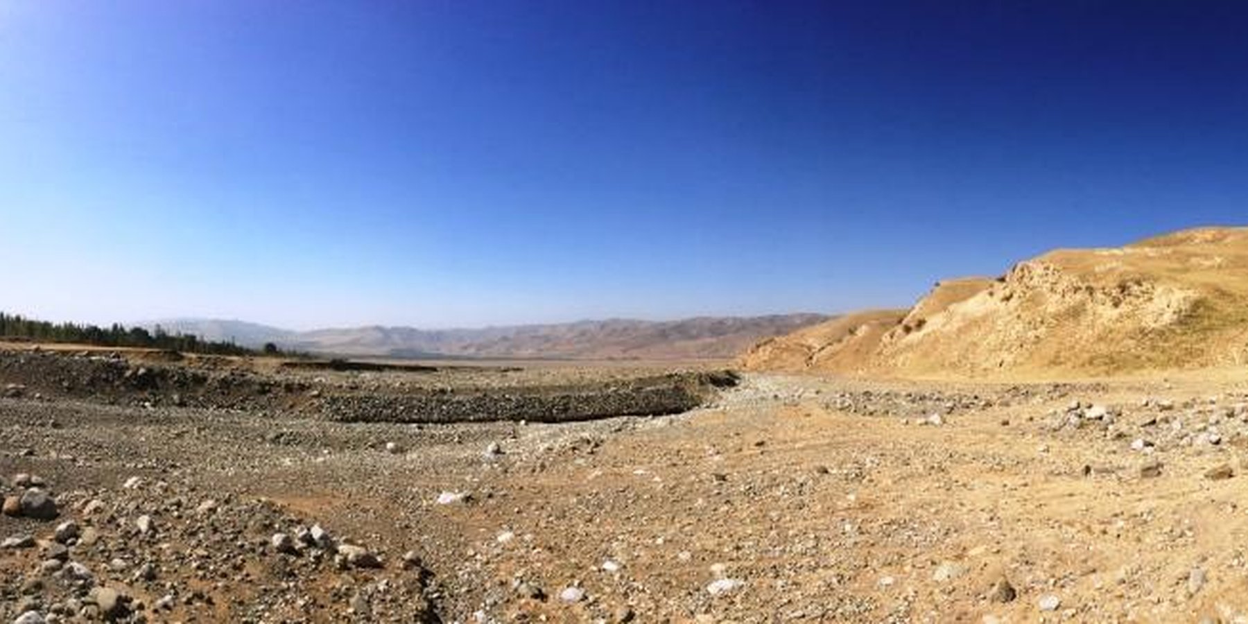
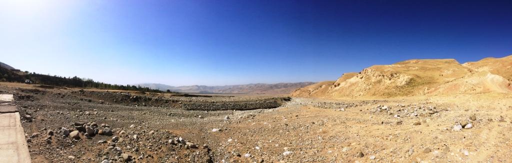
The river training dam is a disaster mitigation structure protecting downstream areas from flash floods and mudflows. It consists of a channel dug and wire net gabions built to train the river and is hence cheap to establish and maintain. There is a substantial community contribution as labour is an important part of the input costs. The dam enables the rehabilitation of unproductive land in the downstream catchment areas, reduction of crop pests, increase in crop diversity and land productivity, and an overall improvement of livelihoods for downstream communities through reduced vulnerability to disasters.
2.2 ការពណ៌នាលម្អិតពីបច្ចេកទេស
ការពណ៌នា:
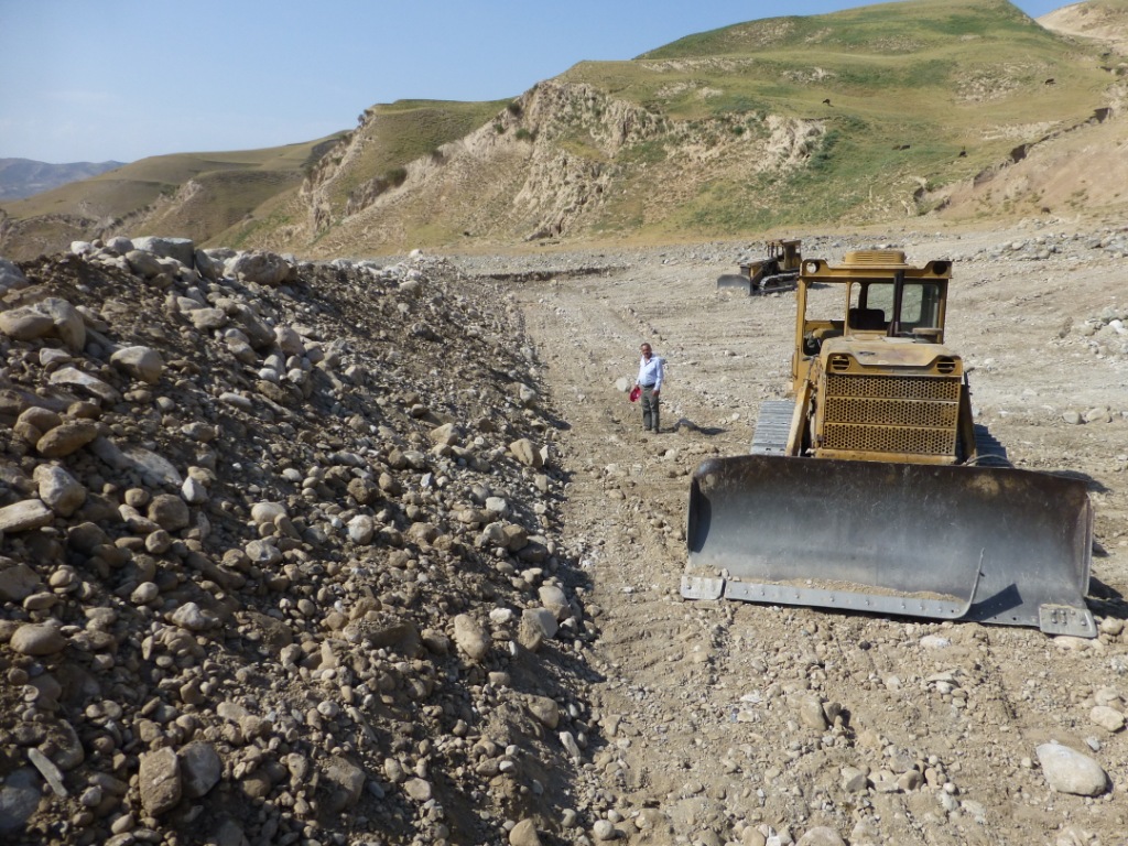
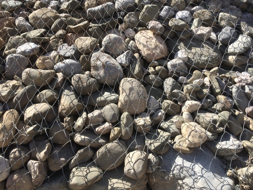
The river training dam is a disaster mitigation structure constructed in the middle zone of the watershed of Obishur (Southern Tajikistan), at 1400 metres above sea level. It is diverting the water from the river fan naturally flowing through Kulchashma village into a different direction and river outlet (Yakhsu river). The dike is a simple structure consisting of a 400m-long and 4m-high channel dug by bulldozer consolidated by a 60m-long and 3m-wide gabion protecting a sharp curve of the river. The material needed is limited to stones and wire net, and the construction as well as maintenance costs are hence low and don't need a too high amount of labour, provided by the communities as in-kind contribution. The structure is built to resist a pressure of up to 72 m3/sec. Given the annual frequency and strength of the local floods, the Kulchashma river training dam has an estimated life expectancy of 30 years. The land users proposed to establish the dam in order to protect the 250 households and 270 ha of land downstream being regularly affected by the floods. In particular, people, houses, roads and other infrastructure, crop and pasture land as well as animals and other assets were highly exposed to the risk of flood. The agricultural production, constituting the main part of people’s income was hindered by the regular occurrence of disasters. The establishment of the river training dam resulted in the rehabilitation of unproductive land in the river fan and its use as pasture and arable land which the community mainly uses for agroforestry. The occurrence of crop pests decreased, the crop diversity was increased, the crop and land productivity improved, thereby enhancing the land users’ food security and overall income. The dam also allowed vulnerable community members to access land and build houses. The construction of buildings behind the dam is however risky and communities tend to forget or ignore that a risk of failure of the dam persists, and that its life expectancy is limited. But first of all, the personal safety of the community members is now improved and they are happy to be able to sleep without the fear of regular floods.
2.3 រូបភាពនៃបច្ចេកទេស
វិចិត្រសាលប្រព័ន្ធផ្សព្វផ្សាយ
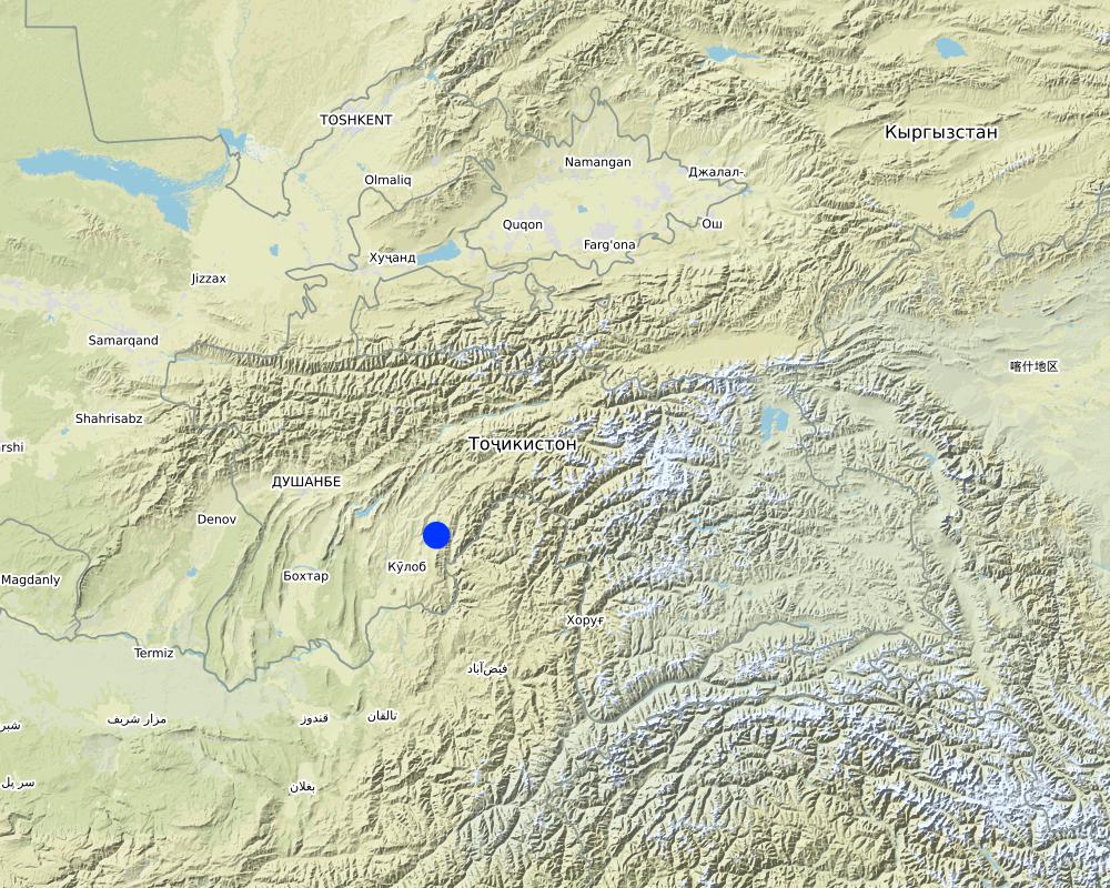
2.5 ប្រទេស/តំបន់/ទីតាំងកន្លែង ដែលបច្ចេកទេសត្រូវបានអនុវត្ត និងបានគ្រប់ដណ្តប់ដោយការវាយតម្លៃនេះ
ប្រទេស:
ប្រទេសតាហ្ស៊ីគីស្ថាន
តំបន់/រដ្ឋ/ខេត្ត:
Khatlon Region, Muminabad District
បញ្ជាក់បន្ថែមពីលក្ខណៈនៃទីតាំង:
Kulchashma Jamoat, Kulchashma village
បញ្ជាក់ពីការសាយភាយនៃបច្ចេកទេស:
- អនុវត្តនៅកន្លែងជាក់លាក់មួយ/ ប្រមូលផ្តុំនៅតំបន់តូចៗ
មតិយោបល់:
water diversion and drainage
Map
×2.6 កាលបរិច្ឆេទនៃការអនុវត្ត
បង្ហាញឆ្នាំនៃការចុះអនុវត្ត:
2014
2.7 ការណែនាំពីបច្ចេកទេស
សូមបញ្ជាក់តើបច្ចេកទេសត្រូវបានណែនាំឱ្យអនុវត្តដោយរបៀបណា:
- តាមរយៈការបង្កើតថ្មីរបស់អ្នកប្រើប្រាស់ដី
មតិយោបល់ (ប្រភេទនៃគម្រោង ។ល។):
The adoption of the technology was proposed by the land users.
3. ចំណាត់ថ្នាក់នៃបច្ចេកទេស SLM
3.1 គោលបំណងចម្បង (១ ឬច្រើន) នៃបច្ចេកទេសនេះ
- ធ្វើឱ្យប្រសើរឡើងនូវផលិតកម្ម
- កាត់បន្ថយ, បង្ការ, ស្តារឡើងវិញនូវការធ្លាក់ចុះគុណភាពដី
- ការពារតំបន់ទីជម្រាល/តំបន់ខ្សែទឹកខាងក្រោមបញ្ចូលជាមួយបច្ចេកទេសផ្សេងទៀត
- កាត់បន្ថយហានិភ័យនៃគ្រោះមហន្តរាយ
- បង្កើតផលប្រយោជន៍សេដ្ឋកិច្ច
3.2 ប្រភេទដីប្រើប្រាស់មួយប្រភេទ (ច្រើនប្រភេទ) ដែលបានអនុវត្តបច្ចេកទេស

ដីសម្រាប់ចិញ្ចឹមសត្វ
វាលស្មៅធំៗ:
- ពាក់កណ្តាលពនេចរ
3.4 ការផ្គត់ផ្គង់ទឹក
ការផ្គត់ផ្គង់ទឹកនៅកន្លែងអនុវត្តបច្ចេកទេស:
- ទឹកភ្លៀង និងប្រព័ន្ធស្រោចស្រព
មតិយោបល់:
Irrigation - main irrigation channels also received water diverted by the dam.
3.5 ក្រុម SLM ដែលបច្ចេកទេសស្ថិតនៅក្នុង
- ការបែងចែកទឹក និងប្រព័ន្ធបង្ហូរ
3.6 វិធានការ SLM ដែលបញ្ចូលនូវបច្ចេកទេស

វិធានការរចនាស័ម្ពន្ធ
- S3: កម្ពស់ភ្លឺ ប្រឡាយ ផ្លូវទឹក
- S5: ទំនប់ ថ្លុក ស្រះ
3.7 កំណត់ប្រភេទនៃការធ្លាក់ចុះគុណភាពដីសំខាន់ៗដែលបច្ចេកទេសនេះបានដោះស្រាយ

ការហូរច្រោះដីដោយសារទឹក
- Wt: ការបាត់ដីស្រទាប់លើដោយការហូរច្រោះ
- Wg: ការកកើតឡើងនូវកំទេចកំទីដីស្រទាប់ក្រោម
- Wr: សំណឹកដីច្រាំងទន្លេ
- Wo: ផលប៉ះពាល់នៃការធ្លាក់ចុះគុណភាពកន្លែងឆ្ងាយ

ការធ្លាក់ចុះជីវសាស្ត្រនៃដី
- Bc: ការថយចុះនូវគម្របរុក្ខជាតិ
- Bh: ការបាត់បង់ទីជំរក
- Bq: ការថយចុះនូវជីវម៉ាស/ បរិមាណ
- Bl: ការបាត់បង់មីក្រូ និងម៉ាក្រូសរីរាង្គរបស់ដី
- Bp: ការកើនឡើងនូវសត្វល្អិត ឬជំងឺ បាត់បង់នូវសត្វមានប្រយោជន៍

ការបាត់បង់ទឹក
- Hs: ការប្រែប្រួលបរិមាណទឹកនៅលើផ្ទៃដី
- Hp: ការថយចុះគុណភាពទឹកនៅលើផ្ទៃដី
- Hq: ការថយចុះគុណភាពទឹកនៅក្រោមដី
មតិយោបល់:
Improvement of groundwater quality is not the focus of the project but the technology has an impact on this type of natural degradation process.
3.8 ការពារ កាត់បន្ថយ ឬស្តារឡើងវិញនៃការធ្លាក់ចុះគុណភាពដី
បញ្ជាក់ពីគោលដៅរបស់បច្ចេកទេស ដែលផ្តោតទៅការធ្លាក់ចុះគុណភាពដី:
- ការកាត់បន្ថយការធ្លាក់ចុះគុណភាពដី
- ការជួសជុល/ ស្តារឡើងវិញនៃឱនភាពដីធ្ងន់ធ្ងរ
មតិយោបល់:
Flood sediments are diverted by the dam and its accumulation in the lower zone of the watersheds is prevented, thereby allowing the rehabilitation of arable land downstream.
4. បច្ចេកទេសជាក់លាក់ សកម្មភាពអនុវត្ត ធាតុចូល និងថ្លៃដើម
4.1 គំនូសបច្ចេកទេសនៃបច្ចេកទេសនេះ
លក្ខណៈពិសេសនៃបច្ចេកទេស (ទាក់ទងនឺងគំនូរបច្ចេកទេស):
Specify how costs and inputs were calculated:
per Technology unit
Specify unit:
Dam
Specify dimensions of unit (if relevant):
400m-long dug channel and 60m-long gabion
Specify currency used for cost calculations:
USD
ឈ្មោះអ្នកនិពន្ធ:
Sady Odinashoev
កាលបរិច្ឆេទ:
01/08/2013
4.2 ព័ត៌មានទូទៅដែលពាក់ព័ន្ធនឹងការគណនាធាតុចូល និងថ្លៃដើម
កំណត់របៀបនៃការគណនាថ្លៃដើម និងធាតុចូល:
- ក្នុងឯកតាបច្ចេកទេស
បញ្ជាក់ឯកតា:
Dam
បញ្ជាក់ពីទំហំនៃឯកតា (បើពាក់ព័ន្ធ):
400m-long dug channel and 60m-long gabion
កំណត់រូបិយប័ណ្ណសម្រាប់ថ្លៃដើម:
- ដុល្លារ
4.3 សកម្មភាពបង្កើត
| សកម្មភាព | រយៈពេល (រដូវកាល) | |
|---|---|---|
| 1. | 400m-long channel digging (bulldozer) | August-October |
| 2. | Stone collection | October (10 days) |
| 3. | Construction of gabions | November (15 days) |
មតិយោបល់:
Establishment activities to be completed before the cold and snow/rain season.
4.4 ថ្លៃដើម និងធាតុចូលដែលត្រូវការសម្រាប់ការបង្កើតបច្ចេកទេស
| បញ្ជាក់ពីធាតុចូល | ឯកតា | បរិមាណ | ថ្លៃដើមក្នុងមួយឯកតា | ថ្លៃធាតុចូលសរុប | % នៃថ្លៃដើមដែលចំណាយដោយអ្នកប្រើប្រាស់ដី | |
|---|---|---|---|---|---|---|
| កម្លាំងពលកម្ម | Construction of wire net gabions | person-hours | 1400,0 | 1,5 | 2100,0 | 100,0 |
| កម្លាំងពលកម្ម | Bulldozer driving | person-hours | 150,0 | 1,5 | 225,0 | |
| សម្ភារៈ | Bulldozer rent | day | 15,0 | 63,0 | 945,0 | |
| សម្ភារៈ | Fuel for bulldozer | litre | 2250,0 | 1,35 | 3037,5 | |
| សម្ភារៈ | Diesel oil for bulldozer | litre | 68,0 | 2,13 | 144,84 | |
| សម្ភារៈ | Spindle oil for bulldozer | litre | 45,0 | 2,0 | 90,0 | |
| សម្ភារៈសាងសង់ | wire net (diametre 4mm) | m2 | 625,0 | 1,6 | 1000,0 | |
| សម្ភារៈសាងសង់ | wire (diametre 3mm) | kg | 26,0 | 1,6 | 41,6 | |
| ផ្សេងៗ | Gearbox oil for bulldozer | litre | 22,0 | 2,5 | 55,0 | |
| ផ្សេងៗ | Solid oil for bulldozer | litre | 22,0 | 3,0 | 66,0 | |
| ផ្សេងៗ | Gas for bulldozer | litre | 22,0 | 1,4 | 30,8 | |
| ថ្លៃដើមសរុបក្នុងការបង្កើតបច្ចេកទេស | 7735,74 | |||||
| ថ្លៃដើមសរុបក្នុងការបង្កើតបច្ចេកទេសគិតជាដុល្លារ | 7735,74 | |||||
ប្រសិនបើអ្នកប្រើប្រាស់ដីមិនមានថ្លៃដើម 100% សូមបញ្ជាក់ថានរណាដែលចំណាយថ្លៃដើមដែលនៅសល់:
Rent of bulldozer + bulldozer driving covered by local district government. All other costs covered by project.
មតិយោបល់:
Cost-sharing for establishment and maintenance activities is agreed upon when determining the design and implementation of the dam as part of the project conditions.
4.5 សកម្មភាពថែទាំ
| សកម្មភាព | ពេលវេលា/ ភាពញឹកញាប់ | |
|---|---|---|
| 1. | Fixing of wire net gabions | March, annually |
មតិយោបល់:
Maintenance activities to be conducted before peak rain/snowmelt/flood season.
4.6 កំណត់ថ្លៃដើមសម្រាប់ការថែទាំ/ សកម្មភាពរបស់បច្ចេកទេស (ក្នុងរយៈពេលមួយឆ្នាំ)
| បញ្ជាក់ពីធាតុចូល | ឯកតា | បរិមាណ | ថ្លៃដើមក្នុងមួយឯកតា | ថ្លៃធាតុចូលសរុប | % នៃថ្លៃដើមដែលចំណាយដោយអ្នកប្រើប្រាស់ដី | |
|---|---|---|---|---|---|---|
| កម្លាំងពលកម្ម | Fixing wire net (by Self Help Group) | hour | 40,0 | 0,8 | 32,0 | 100,0 |
| សម្ភារៈសាងសង់ | wire net | kg | 7,0 | 1,0 | 7,0 | 100,0 |
| ថ្លៃដើមសរុបសម្រាប់ការថែទាំដំណាំតាមបច្ចេកទេស | 39,0 | |||||
| ថ្លៃដើមសរុបសម្រាប់ការថែទាំដំណាំតាមបច្ចេកទេសគិតជាដុល្លារ | 39,0 | |||||
មតិយោបល់:
All maintenance costs covered by land users.
4.7 កត្តាសំខាន់បំផុតដែលមានឥទ្ធិពលដល់ការចំណាយ
ពណ៌នាពីកត្តាប៉ះពាល់ចម្បងៗទៅលើថ្លៃដើម:
- Geography (steep hills to dig a diverting channel increases the establishment costs)
- Geology (quality/type of soil affects the time needed for digging)
5. លក្ខណៈបរិស្ថានធម្មជាតិ និងមនុស្ស
5.1 អាកាសធាតុ
បរិមាណទឹកភ្លៀងប្រចាំឆ្នាំ
- < 250 មម
- 251-500 មម
- 501-750 មម
- 751-1,000 មម
- 1,001-1,500 មម
- 1,501-2,000 មម
- 2,001-3,000 មម
- 3,001-4,000 មម
- > 4,000 មម
លក្ខណៈពិសេស/ មតិយោបល់លើរដូវភ្លៀង:
Varies very much from year to year.
បញ្ជាក់ឈ្មោះឯកសារយោងនៃស្ថានីយឧតុនិយម:
Muminabad meteo station (1200 m a.s.l.)
តំបន់កសិអាកាសធាតុ
- មានភ្លៀងតិចតួច
Average temperatures:
Spring:10-32°C
Summer: 20-35°C
Autumn: 10-32°C
Winter: -5-+5°C
Average yearly temperature: 11.1°C
5.2 សណ្ឋានដី
ជម្រាលជាមធ្យម:
- រាបស្មើ (0-2%)
- ជម្រាលតិចតួច (3-5%)
- មធ្យម (6-10%)
- ជម្រាលខ្ពស់បន្តិច (11-15%)
- ទីទួល (16-30%)
- ទីទួលចោត (31-60%)
- ទីទួលចោតខ្លាំង (>60%)
ទម្រង់ដី:
- ខ្ពង់រាប
- កំពូលភ្នំ
- ជម្រាលភ្នំ
- ជម្រាលទួល
- ជម្រាលជើងភ្នំ
- បាតជ្រលងភ្នំ
តំបន់តាមរយៈកម្ពស់ :
- 0-100 ម
- 101-500 ម
- 501-1,000 ម
- 1,001-1,500 ម
- 1,501-2,000 ម
- 2,001-2,500 ម
- 2,501-3,000 ម
- 3,001-4,000 ម
- > 4,000 ម
បញ្ជាក់ថាតើបច្ចេកទេសនេះត្រូវបានអនុវត្តន៍នៅក្នុង:
- សណ្ឋានដីផត
5.3 ដី
ជម្រៅដីជាមធ្យម:
- រាក់ខ្លាំង (0-20 សម)
- រាក់ (21-50 សម)
- មធ្យម (51-80 សម)
- ជ្រៅ (81-120 សម)
- ជ្រៅខ្លាំង (> 120 សម)
វាយនភាពដី (ស្រទាប់លើ):
- គ្រើម/ មានពន្លឺ (ខ្សាច់)
- មធ្យម (ល្បាយ, ល្បាប់)
វាយនភាពដី (> 20 សម ស្រទាប់ក្នុង):
- គ្រើម/ មានពន្លឺ (ខ្សាច់)
- មធ្យម (ល្បាយ, ល្បាប់)
សារធាតុសរីរាង្គនៅស្រទាប់ដីខាងលើ:
- ទាប (<1%)
បើអាចសូមភ្ជាប់ការពណ៌នាពីដីឱ្យបានច្បាស់ ឬព័ត៌មានដែលអាចទទួលបាន ឧ. ប្រភេទដី, pH ដី/ ជាតិអាស៊ីត, សមត្ថភាពផ្លាស់ប្តូរកាចុង, វត្តមាននីត្រូសែន, ភាពប្រៃ ។ល។:
On southern (sunny) side of the hills, loess type of soil. On northern (shady) side of the hills, humus type of soil
5.4 ទឹកដែលអាចទាញមកប្រើប្រាស់បាន និងគុណភាពទឹក
នីវ៉ូទឹកក្រោមដី:
> 50 ម
ទឹកលើដីដែលអាចទាញយកប្រើប្រាស់បាន:
លើស
គុណភាពទឹក (មិនបានធ្វើប្រត្តិកម្ម):
ទឹកពិសារដែលមានគុណភាពល្អ
តើមានបញ្ហាភាពទឹកប្រៃហូរចូលមកដែរឬទេ?
ទេ
តើទឹកជំនន់កំពុងកើតមាននៅតំបន់នេះដែររឺទេ?
បាទ/ចា៎
ភាពទៀងទាត់:
ម្តងម្កាល
មតិយោបល់ និងលក្ខណៈពិសេសផ្សេងៗទៀតលើគុណភាព និងបរិមាណទឹក :
Seasonal floods/high runoff in spring time, when heavy rain coincides with snowmelt.
5.5 ជីវៈចម្រុះ
ភាពសម្បូរបែបនៃប្រភេទ:
- កម្រិតមធ្យម
ភាពសម្បូរបែបនៃទីជម្រក:
- កម្រិតមធ្យម
5.6 លក្ខណៈនៃអ្នកប្រើប្រាស់ដីដែលអនុវត្តបច្ចេកទេស
នៅមួយកន្លែង ឬពនេចរ :
- នៅមួយកន្លែង
ទីផ្សារនៃប្រព័ន្ធផលិតកម្ម:
- សម្រាប់ហូបក្នុងគ្រួសារ (ផ្គត់ផ្គង់ខ្លួនឯង)
ចំណូលក្រៅកសិកម្ម:
- 10-50% នៃចំណូល
កម្រិតជីវភាព:
- មធ្យម
ឯកជន ឬក្រុម:
- ធ្វើខ្លួនឯង/ គ្រួសារ
កម្រិតប្រើប្រាស់គ្រឿងយន្ត:
- ប្រើកម្លាំងពលកម្ម
- គ្រឿងយន្ត/ ម៉ាស៊ីន
យេនឌ័រ:
- ស្ត្រី
- បុរស
អាយុរបស់អ្នកប្រើប្រាស់ដី:
- យុវវ័យ
- វ័យកណ្តាល
5.7 ទំហំផ្ទៃដីជាមធ្យមនៃដីប្រើប្រាស់ដោយអ្នកប្រើប្រាស់ដី ក្នុងការអនុវត្តបច្ចេកទេស
- < 0.5 ហិកតា
- 0.5-1 ហិកតា
- 1-2 ហិកតា
- 2-5 ហិកតា
- 5-15 ហិកតា
- 15-50 ហិកតា
- 50-100 ហិកតា
- 100-500 ហិកតា
- 500-1,000 ហិកតា
- 1,000-10,000 ហិកតា
- > 10,000 ហិកតា
តើផ្ទៃដីនេះចាត់ទុកជាទំហំកម្រិតណាដែរ ខ្នាតតូច មធ្យម ឬខ្នាតធំ (ធៀបនឹងបរិបទតំបន់)?
- ខ្នាតមធ្យម
5.8 ភាពជាម្ចាស់ដី កម្មសិទ្ធប្រើប្រាស់ដី និងកម្មសិទ្ធប្រើប្រាស់ទឹក
ភាពជាម្ចាស់ដី:
- រដ្ឋ
កម្មសិទ្ធិប្រើប្រាស់ដី:
- កិច្ចសន្យាជួល
កម្មសិទ្ធប្រើប្រាស់ទឹក:
- ជាក្រុម (មានដែនកំណត់)
5.9 ការប្រើប្រាស់សេវាកម្ម និងហេដ្ឋារចនាសម្ព័ន្ធ
សុខភាព:
- មិនល្អ
- មធ្យម
- ល្អ
ការអប់រំ:
- មិនល្អ
- មធ្យម
- ល្អ
ជំនួយបច្ចេកទេស:
- មិនល្អ
- មធ្យម
- ល្អ
ការងារ (ឧ. ការងារក្រៅកសិដ្ឋាន):
- មិនល្អ
- មធ្យម
- ល្អ
ទីផ្សារ:
- មិនល្អ
- មធ្យម
- ល្អ
ថាមពល:
- មិនល្អ
- មធ្យម
- ល្អ
ផ្លូវ និងការដឹកជញ្ជូន:
- មិនល្អ
- មធ្យម
- ល្អ
ទឹកផឹក និងអនាម័យ:
- មិនល្អ
- មធ្យម
- ល្អ
សេវាកម្មហិរញ្ញវត្ថុ:
- មិនល្អ
- មធ្យម
- ល្អ
6. ផលប៉ះពាល់ និងការសន្និដ្ឋាន
6.1 ផលប៉ះពាល់ក្នុងបរិវេណអនុវត្តបច្ចេកទេសដែលកើតមាន
ផលប៉ះពាល់លើសេដ្ឋកិច្ចសង្គម
ផលិតផល
ផលិតកម្មដំណាំ
គុណភាពមុន SLM:
No production
គុណភាពក្រោយ SLM:
Self-use + surplus sold on market
មតិយោបល់/ ការបញ្ជាក់:
6000 kg onions/ ha
គុណភាពដំណាំ
មតិយោបល់/ ការបញ្ជាក់:
35-40% increase
ផលិតកម្មចំណីសត្វ
មតិយោបល់/ ការបញ្ជាក់:
On average 50% increase of fodder. Additionally, fodder crop seeds (lucerne) can be sold; increases land users' income.
គុណភាពចំណីសត្វ
ផលិតកម្មសត្វ
ហានិភ័យនៃភាពបរាជ័យរបស់ផលិតកម្ម
មតិយោបល់/ ការបញ្ជាក់:
One of the main and most important impact
ភាពសម្បូរបែបនៃផលិតផល
ផ្ទៃដីផលិតកម្ម
មតិយោបល់/ ការបញ្ជាក់:
25-30% increase in production area in lowlands (downstream) through rehabilitation of unproductive land which was previously regularly flooded and covered by sediments.
ការគ្រប់គ្រងដី
មតិយោបល់/ ការបញ្ជាក់:
Trees newly planted are used for riverbed protection and fuelwood production
ទឹកដែលអាចទាញមកប្រើប្រាស់បាន និងគុណភាពទឹក
ទឹកបរិភោគដែលអាចទាញយកមកប្រើប្រាស់បាន
មតិយោបល់/ ការបញ្ជាក់:
Floods do not contaminate spring drinking waters with sediments
គុណភាពទឹកបរិភោគ
ទឹកប្រើប្រាស់សម្រាប់ស្រោចស្រព
មតិយោបល់/ ការបញ្ជាក់:
Irrigation channel not destroyed by annual floods anymore.
ចំណូល និងថ្លៃដើម
ការចំណាយលើធាតុចូលកសិកម្ម
មតិយោបល់/ ការបញ្ជាក់:
Pests decreased.
ចំណូលក្នុងកសិដ្ឋាន
មតិយោបល់/ ការបញ្ជាក់:
Through rehabilitation of unproductive land in river fan.
ភាពសម្បូរបែបប្រភពប្រាក់ចំណូល
ផលប៉ះពាល់ទៅលើសេដ្ឋកិច្ចសង្គមផ្សេងៗ
orchards
ផលប៉ះពាល់ទៅលើវប្បធម៌សង្គម
សន្តិសុខស្បៀង/ ភាពគ្រប់គ្រាន់ខ្លួនឯង
មតិយោបល់/ ការបញ្ជាក់:
Cultivation of wheat plots and vegetables for self-use and sale
ស្ថានភាពសុខភាព
កម្មសិទ្ធដីប្រើប្រាស់/ ទឹក
មតិយោបល់/ ការបញ្ជាក់:
Previously unused land in the river fan is now registered as pasture land with a land certificate for the use of the community, and new houses where also built on this land.
ឱកាសនៃការបង្កើតថ្មី
ស្ថាប័នសហគមន៍
មតិយោបល់/ ការបញ្ជាក់:
Taxes can be collected with the registration and certification of pasture land and with the authorisation of house construction.
ចំណេះដឹង SLM / ការធ្លាក់ចុះគុណភាពដី
ស្ថានភាពក្រុមដែលមានបញ្ហាក្នុងសង្គម និងសេដ្ឋកិច្ច
មតិយោបល់/ ការបញ្ជាក់:
With dam constructed, economically disadvantaged people have space for building a house on the rehabilitated land.
ផលប៉ះពាល់ទៅលើអេកូឡូស៊ី
វដ្តទឹក/លំហូរ
លំហូរទឹកលើផ្ទៃដី
ប្រព័ន្ធបង្ហូរទឹក
ដី
គម្របដី
ការបាត់បង់ដី
ការកើនឡើងដី
វដ្តនៃសារធាតុចិញ្ចឹម/ការទទួលបាន
សារធាតុសរីរាង្គដី/ការបូនក្រោមដី
ជីវចម្រុះ៖ ដំណាំ, សត្វ
ដំណាំគម្រប
ភាពសម្បូរបែបនៃរុក្ខជាតិ
ការគ្រប់គ្រងកត្តាចង្រៃ/ ជំងឺ
ការកាត់បន្ថយហានិភ័យនៃគ្រោះមហន្តរាយ និងគ្រោះអាកាសធាតុ
ផលប៉ះពាល់នៃទឹកជំនន់
ដីបាក់/ លំហូរកំទិចកំទី
6.2 ផលប៉ះពាល់ក្រៅបរិវេណអនុវត្តបច្ចេកទេសដែលកើតមាន
លំហូរទឹកដែលអាចប្រើប្រាស់បាននៅរដូវប្រាំង
ទឹកជំនន់ខ្សែទឹកខាងក្រោម
កំណកល្បាប់ខ្សែទឹកខាងក្រោម
ខូចខាតដល់ស្រែអ្នកជិតខាង
ខូចខាតដល់ហេដ្ឋារចនាសម្ព័ន្ធសាធារណៈ/ឯកជន
វាយតម្លៃផលប៉ះពាល់ក្រៅបរិវេណអនុវត្តបច្ចេកទេស (វាស់វែង):
In the last three years no flood affected the downstream village. 330ha of land situated downstream of the dam has been rehabilitated, cleaned from big stones, and used fully as pasture. No sediment flood affected the use of this rehabilitated land.
6.3 ភាពប្រឈម និងភាពរួសនៃបច្ចេកទេសទៅនឹងការប្រែប្រួលអាកាសធាតុ និងគ្រោះអាកាសធាតុ/ គ្រោះមហន្តរាយ (ដែលដឹងដោយអ្នកប្រើប្រាស់ដី)
ការប្រែប្រួលអាកាសធាតុ
ការប្រែប្រួលអាកាសធាតុ
| រដូវកាល | កើនឡើង ឬថយចុះ | លក្ខណៈឆ្លើយតបនៃបច្ចេកទេសទៅនឹងការប្រែប្រួលអាកាសធាតុ | |
|---|---|---|---|
| បរិមាណទឹកភ្លៀងប្រចាំឆ្នាំ | កើនឡើង | ល្អ | |
| បរិមាណទឹកភ្លៀងប្រចាំរដូវកាល | និទាឃរដូវ | កើនឡើង | ល្អ |
គ្រោះអាកាសធាតុ (មហន្តរាយ)
គ្រោះមហន្តរាយទឹក
| លក្ខណៈឆ្លើយតបនៃបច្ចេកទេសទៅនឹងការប្រែប្រួលអាកាសធាតុ | |
|---|---|
| ទឹកជំនន់ទូទៅ (ទន្លេ) | ល្អណាស់ |
| ទឹកជំនន់ដោយទឹកភ្លៀង | ល្អណាស់ |
6.4 ការវិភាគថ្លៃដើម និងអត្ថប្រយោជន៍
តើផលចំណេញ និងថ្លៃដើមត្រូវបានប្រៀបធៀបគ្នាយ៉ាងដូចម្តេច (ទស្សនៈរបស់អ្នកប្រើប្រាស់ដី)?
រយៈពេលខ្លី:
វិជ្ជមានខ្លាំង
តើផលចំណេញ និងការថែទាំ/ ជួសជុលត្រូវបានប្រៀបធៀបគ្នាយ៉ាងដូចម្តេច (ទស្សនៈរបស់អ្នកប្រើប្រាស់ដី)?
រយៈពេលខ្លី:
វិជ្ជមានខ្លាំង
មតិយោបល់:
From the land-user perspective, the benefit assessment of the establishment costs could only be done in relation to the land-users' contribution (i.e. 10% of establishment costs in cash or USD 600 , plus labour).
Because the dam was constructed less than 10 years ago, the long-terms returns cannot be assessed yet.
6.5 ការទទួលយកបច្ចេកទេស
- > 50%
បើអាច សូមបញ្ជាក់ពីបរិមាណ (ចំនួនគ្រួសារ និង/ ឬតំបន់គ្របដណ្តប់):
250 households and 270 ha covered, i.e. 50% of Kulchashma village's population.
ក្នុងចំណោមគ្រួសារទាំងអស់ដែលបានអនុវត្តបច្ចេកទេស តើមានប៉ុន្មានគ្រួសារដែលចង់ធ្វើដោយខ្លួនឯង ដោយមិនទទួលបានសម្ភារៈលើកទឹកចិត្ត/ប្រាក់ឧបត្ថម្ភ?:
- 0-10%
មតិយោបល់:
This low percentage is explained by the fact that a structural measure like a dam construction is a big collective investment and can only be initiated as a group with coordination.
6.6 ការបន្សុំា
តើថ្មីៗនេះ បច្ចេកទេសនេះត្រូវបានកែតម្រូវដើម្បីបន្ស៊ាំទៅនឹងស្ថានភាពប្រែប្រួលដែរឬទេ?
ទេ
6.7 ភាពខ្លាំង/ គុណសម្បត្តិ/ ឱកាសនៃបច្ចេកទេស
| ភាពខ្លាំង/ គុណសម្បត្តិ/ ឱកាសនៅកន្លែងរបស់អ្នកប្រើប្រាស់ដី |
|---|
| The construction and maintenance of a river training dam prevents further land degradation caused by floods, allows the rehabilitation of unused land to create new pastures, and above all increases people's and livestock's safety. |
| ភាពខ្លាំង/ គុណសម្បត្តិ/ ឱកាស ទស្សនៈរបស់បុគ្គលសំខាន់ៗ |
|---|
| General improvement of life quality, including life safety and opportunities to protect assets and improve livelihoods. |
6.8 ភាពខ្សោយ/ គុណវិបត្តិ/ ហានិភ័យនៃបច្ចេកទេស និងវិធីសាស្ត្រដោះស្រាយ
| ភាពខ្សោយ/ គុណវិបត្តិ/ ហានិភ័យ ទស្សនៈរបស់អ្នកប្រើប្រាស់ដី | តើបច្ចេកទេសទាំងនោះបានដោះស្រាយបញ្ហាដូចម្តេច? |
|---|---|
| None | n/a |
| ភាពខ្សោយ/ គុណវិបត្តិ/ ហានិភ័យ ទស្សនៈរបស់អ្នកចងក្រងឬបុគ្គលសំខាន់ៗ | តើបច្ចេកទេសទាំងនោះបានដោះស្រាយបញ្ហាដូចម្តេច? |
|---|---|
| Downstream communities feel safe behind the dam and tend to ignore the risk of failure in extreme conditions (beyond the coping capacity of the dam). As a consequence, people build houses in places still at risk in the river fan. | Strengthened governance (no authorisation of construction in the river fan/behind the dam in the risk zone). |
7. ឯកសារយោង និងវេបសាយ
7.1 វិធីសាស្ត្រ/ ប្រភពនៃព័ត៌មាន
- ការសម្ភាសន៍ជាមួយអ្នកប្រើប្រាស់ដី
5 land users
- ការសម្ភាសន៍ជាមួយអ្នកជំនាញ/ ឯកទេស
1
តើពេលណាដែលទិន្នន័យបានចងក្រង (នៅទីវាល)?
11/10/2016
ការតភ្ជាប់ និងម៉ូឌុល
ពង្រីកមើលទាំងអស់ បង្រួមទាំងអស់ការតភ្ជាប់
គ្មានការតភ្ជាប់
ម៉ូឌុល
គ្មានម៉ូឌុល