Small-scale conservation tillage [Kenya]
- Creation:
- Update:
- Compiler: Frederick I. Kihara
- Editor: –
- Reviewers: Deborah Niggli, Rima Mekdaschi Studer, Alexandra Gavilano
ConTill (English); Kupiga Tindo (Swahili)
technologies_940 - Kenya
- Full summary as PDF
- Full summary as PDF for print
- Full summary in the browser
- Full summary (unformatted)
- Small-scale conservation tillage: June 3, 2019 (public)
- Small-scale conservation tillage: April 4, 2018 (inactive)
- Small-scale conservation tillage: April 4, 2018 (inactive)
- Small-scale conservation tillage: Aug. 11, 2017 (inactive)
- Small-scale conservation tillage: July 11, 2017 (inactive)
- Small-scale conservation tillage: Dec. 22, 2016 (inactive)
View sections
Expand all Collapse all1. General information
1.2 Contact details of resource persons and institutions involved in the assessment and documentation of the Technology
SLM specialist:
Kiteme Boniface
CETRAD
Kenya
Name of project which facilitated the documentation/ evaluation of the Technology (if relevant)
Book project: where the land is greener - Case Studies and Analysis of Soil and Water Conservation Initiatives Worldwide (where the land is greener)Name of project which facilitated the documentation/ evaluation of the Technology (if relevant)
Book project: SLM in Practice - Guidelines and Best Practices for Sub-Saharan Africa (SLM in Practice)1.3 Conditions regarding the use of data documented through WOCAT
The compiler and key resource person(s) accept the conditions regarding the use of data documented through WOCAT:
Yes
1.4 Declaration on sustainability of the described Technology
Is the Technology described here problematic with regard to land degradation, so that it cannot be declared a sustainable land management technology?
No
1.5 Reference to Questionnaire(s) on SLM Approaches (documented using WOCAT)
2. Description of the SLM Technology
2.1 Short description of the Technology
Definition of the Technology:
Ripping of soil using oxen-drawn implements, to improve water storage capacity and cropland productivity on small-scale farms.
2.2 Detailed description of the Technology
Description:
Laikipia District in Kenya is characterised by a semi-arid climate, high altitude and rolling terrain. Most of the soil and water loss occurs during a few heavy storms at the beginning of each growing season. More than 90% of families have under two hectares of land, and few have alternative sources of income.
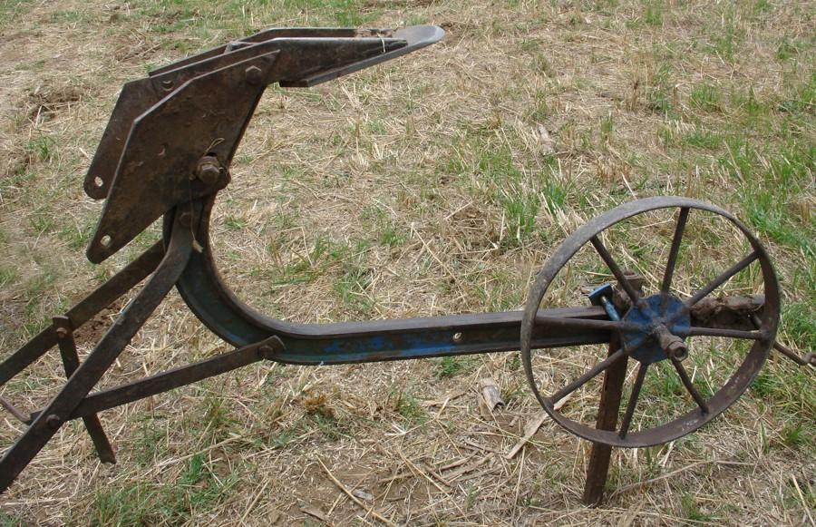
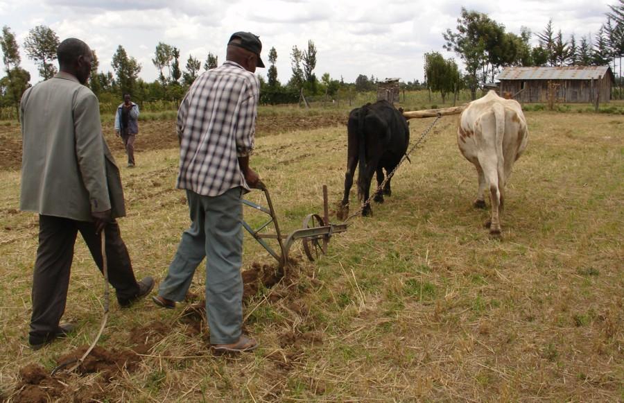
The form of conservation agriculture described in this case study involves the use of ox-drawn ploughs, modified to rip the soil. Ripping is performed in one pass, to a depth of 10 cm, after harvest. Spacing between the rip lines is 30 cm - in the case of wheat. Deep ripping (subsoiling) with the same implement is done, when necessary, to break a plough pan and reaches depths of up to 30 cm. An adaptation to the ordinary plough beam (the common mouldboard ‘Victory’ plough) makes adjustment to different depths possible and turns it into a ripper for surface and deeper ripping.
The aim of ripping is to increase water infiltration and reduce runoff. In contrast to conventional tillage, the soil is not inverted, thus leaving a certain amount of crop residue on the surface. As a result, the soil is less exposed and not so vulnerable to the impact of splash and sheet erosion, and water loss through evaporation and runoff. In addition, there are savings in terms of energy used for cultivation. In well-ripped fields, rainfall from storms at the onset of the growing season is stored within the rooting zone, and is therefore available to the crop during subsequent drought spells. Ripping the soil during the dry season combined with a mulch cover reduces germination of weeds, leaving fields ready for planting. In case of stubborn weeds, pre-emergence herbicides are used for control. Yields from small-scale conservation tillage can be more than 60% higher than under conventional ploughing. An additional important benefit is that crops mature sooner in conservation agriculture, because they can be planted earlier: under inversion tillage the farmer has to wait for the soil to become moist before ploughing. Earlier crop maturity means access to markets when prices are still high.
There are various supportive technologies in use which can improve the effectiveness of the ripping. These include: (1) use of compost/manure to improve soil structure for better water storage; (2) use of a cover crop (eg Mucuna pruriens) planted at the end of the season to prevent erosion, control weeds and improve soil quality; (3) agroforestry: principally Grevillea robusta planted on the field boundaries (see also ‘Grevillea agroforestry system’).
2.3 Photos of the Technology
Media Gallery
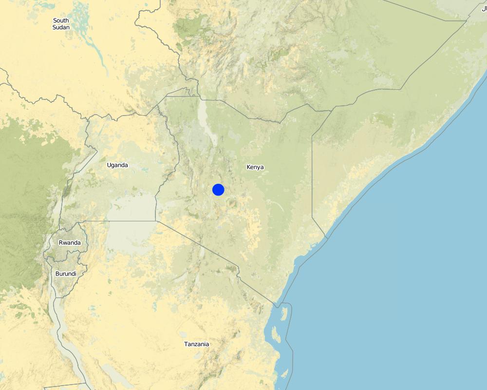
2.5 Country/ region/ locations where the Technology has been applied and which are covered by this assessment
Country:
Kenya
Region/ State/ Province:
Umande, Daiga
Further specification of location:
Laikipia District
Comments:
Total area covered by the SLM Technology is 4 km2.
Expert judgement and group (Mwireri, Kieni, Kalalu villages in Umande sub-district) discussion
Map
×2.6 Date of implementation
If precise year is not known, indicate approximate date:
- less than 10 years ago (recently)
2.7 Introduction of the Technology
Specify how the Technology was introduced:
- through projects/ external interventions
Comments (type of project, etc.):
RELMA (Regional Land Management Unit) development in East and Central Africa
3. Classification of the SLM Technology
3.1 Main purpose(s) of the Technology
- improve production
- reduce, prevent, restore land degradation
3.2 Current land use type(s) where the Technology is applied
Land use mixed within the same land unit:
No

Cropland
- Annual cropping
Annual cropping - Specify crops:
- cereals - maize
- legumes and pulses - beans
- root/tuber crops - potatoes
Number of growing seasons per year:
- 2
Specify:
Longest growing period in days: 120, Longest growing period from month to month: Mar - Jun, Second longest growing period in days: 100, Second longest growing period from month to month: Oct - Jan

Forest/ woodlands
Type of tree:
- Grevillea robusta
Comments:
Trees/ shrubs species: Grevillea robusta
Major land use problems (compiler’s opinion): Loss of rainwater through runoff and direct evaporation from soil surface, runoff causing surface erosion, fertility decline due to erosion and nutrient mining
Major land use problems (land users’ perception): Declining rainfall leading to reduced or no yields. The need to add fertiliser to achieve good yields.
Type of cropping system and major crops comments: Monocrop wheat (March-August) followed by beans/potatoes (Oct-Dec). Maize has a longer growivng season and usually harvested in November but will be intercropped with beans and potatoes (see annex T3). Occasional herbicide usage eg in wheat, 2,4-D is used to control weeds prior to canopy cover. Wheat is mixed with fertiliser prior to planting. Fertiliser placement for all crops is adjacent to seed.
3.4 Water supply
Water supply for the land on which the Technology is applied:
- mixed rainfed-irrigated
3.5 SLM group to which the Technology belongs
- improved ground/ vegetation cover
- minimal soil disturbance
3.6 SLM measures comprising the Technology

agronomic measures
- A3: Soil surface treatment
- A7: Others

vegetative measures
- V1: Tree and shrub cover
Comments:
Specification of other agronomic measures: conserv. tillage (ripping); manure, cover crop (supp.)
Specification of other vegetative measures: Grevillea robusta
Type of agronomic measures: mixed cropping / intercropping, mulching, minimum tillage, contour tillage, breaking compacted subsoil
3.7 Main types of land degradation addressed by the Technology

soil erosion by water
- Wt: loss of topsoil/ surface erosion

physical soil deterioration
- Pc: compaction

water degradation
- Ha: aridification
Comments:
Main causes of degradation: Heavy / extreme rainfall (intensity/amounts) (low rainfall), education, access to knowledge and support services (Lack of knowledge of the technology and low levels of general education)
Secondary causes of degradation: other human induced causes (specify) (agricultural causes - poor varieties eg farmers started growing Kwale wheat, a drought-escaping crop (DEC) that also provides good yields)
3.8 Prevention, reduction, or restoration of land degradation
Specify the goal of the Technology with regard to land degradation:
- reduce land degradation
4. Technical specifications, implementation activities, inputs, and costs
4.1 Technical drawing of the Technology
Technical specifications (related to technical drawing):
Technical knowledge required for field staff / advisors: moderate
Technical knowledge required for land users: moderate
Main technical functions: control of raindrop splash, improvement of ground cover, increase of infiltration, increase / maintain water stored in soil, promote germination due to red. Soil disturbance+ red. Evaporation, improve soil structure
Secondary technical functions: water harvesting / increase water supply
Mixed cropping / intercropping
Material/ species: maize/beans/potatoes
Remarks: see figure in Annex T3 (supp.)
Mulching
Material/ species: crop residue
Quantity/ density: 3-5t/ha
Remarks: ~50% surface cover (supp.)
Minimum tillage
Remarks: to depth of 4inches. Rows 30cm spacing for wheat
Breaking compacted subsoil
Remarks: to depth of 4-6 inches
Vegetative measure: on field boundaries
Vegetative material: T : trees / shrubs
Vegetative measure: Vegetative material: T : trees / shrubs
Trees/ shrubs species: Grevillea robusta
4.2 General information regarding the calculation of inputs and costs
other/ national currency (specify):
Kenya shillings
Indicate average wage cost of hired labour per day:
7.00
4.5 Maintenance/ recurrent activities
| Activity | Timing/ frequency | |
|---|---|---|
| 1. | Spreading of crop residue as mulch: up to 3 t/ha | Dry season / Before planting |
| 2. | Spreading of crop residue as mulch: up to 3 t/ha | Dry season / Before planting |
| 3. | Spreading of crop residue as mulch: up to 3 t/ha | Dry season / Before planting |
| 4. | Spreading of crop residue as mulch: up to 3 t/ha | Dry season / Before planting |
| 5. | Ripping of soil |
4.6 Costs and inputs needed for maintenance/ recurrent activities (per year)
| Specify input | Unit | Quantity | Costs per Unit | Total costs per input | % of costs borne by land users | |
|---|---|---|---|---|---|---|
| Labour | Labour | ha | 1.0 | 25.0 | 25.0 | 100.0 |
| Plant material | Seeds for wheat | kg | 1.0 | 25.0 | 25.0 | 100.0 |
| Fertilizers and biocides | Fertilizer | ha | 1.0 | 8.0 | 8.0 | 100.0 |
| Fertilizers and biocides | Compost / manure | ha | 1.0 | 35.0 | 35.0 | 100.0 |
| Total costs for maintenance of the Technology | 93.0 | |||||
| Total costs for maintenance of the Technology in USD | 93.0 | |||||
Comments:
Machinery/ tools: Pair of oxen and 1 Rampstad plough unit. Note the cost for animal traction includes operator labour. Cost of seeds is for wheat
Cost calculated charges for hiring equipment, draught animals and operator: these are all rolled up into the ‘cost
of labour’ at US$ 25/ha. Conventional tillage costs US$ 37.5/ha compared with US$ 25/ha for conservation tillage operations: other costs remain more or less the same.
4.7 Most important factors affecting the costs
Describe the most determinate factors affecting the costs:
Land preparation cost - equipment, draught animals, operator.
5. Natural and human environment
5.1 Climate
Annual rainfall
- < 250 mm
- 251-500 mm
- 501-750 mm
- 751-1,000 mm
- 1,001-1,500 mm
- 1,501-2,000 mm
- 2,001-3,000 mm
- 3,001-4,000 mm
- > 4,000 mm
Agro-climatic zone
- semi-arid
Thermal climate class: tropics
5.2 Topography
Slopes on average:
- flat (0-2%)
- gentle (3-5%)
- moderate (6-10%)
- rolling (11-15%)
- hilly (16-30%)
- steep (31-60%)
- very steep (>60%)
Landforms:
- plateau/plains
- ridges
- mountain slopes
- hill slopes
- footslopes
- valley floors
Altitudinal zone:
- 0-100 m a.s.l.
- 101-500 m a.s.l.
- 501-1,000 m a.s.l.
- 1,001-1,500 m a.s.l.
- 1,501-2,000 m a.s.l.
- 2,001-2,500 m a.s.l.
- 2,501-3,000 m a.s.l.
- 3,001-4,000 m a.s.l.
- > 4,000 m a.s.l.
5.3 Soils
Soil depth on average:
- very shallow (0-20 cm)
- shallow (21-50 cm)
- moderately deep (51-80 cm)
- deep (81-120 cm)
- very deep (> 120 cm)
Soil texture (topsoil):
- medium (loamy, silty)
- fine/ heavy (clay)
Topsoil organic matter:
- medium (1-3%)
- low (<1%)
5.6 Characteristics of land users applying the Technology
Market orientation of production system:
- subsistence (self-supply)
- mixed (subsistence/ commercial)
Off-farm income:
- 10-50% of all income
Relative level of wealth:
- poor
- average
Individuals or groups:
- groups/ community
Indicate other relevant characteristics of the land users:
Population density: 100-200 persons/km2
Annual population growth: > 4%
5% of the land users are very rich and own 15% of the land.
5% of the land users are rich and own 10% of the land.
15% of the land users are average wealthy and own 20% of the land.
70% of the land users are poor and own 50% of the land.
5% of the land users are poor and own 5% of the land.
Off-farm income specification: many small-scale farmers work part time as casual labourers on large-scale horticultural farms
5.7 Average area of land used by land users applying the Technology
- < 0.5 ha
- 0.5-1 ha
- 1-2 ha
- 2-5 ha
- 5-15 ha
- 15-50 ha
- 50-100 ha
- 100-500 ha
- 500-1,000 ha
- 1,000-10,000 ha
- > 10,000 ha
Is this considered small-, medium- or large-scale (referring to local context)?
- small-scale
5.8 Land ownership, land use rights, and water use rights
Land ownership:
- individual, titled
Land use rights:
- leased
- individual
6. Impacts and concluding statements
6.1 On-site impacts the Technology has shown
Socio-economic impacts
Production
crop production
fodder production
Income and costs
farm income
Socio-cultural impacts
community institutions
SLM/ land degradation knowledge
Ecological impacts
Water cycle/ runoff
surface runoff
Quantity before SLM:
50
Quantity after SLM:
20
excess water drainage
evaporation
Soil
soil moisture
soil cover
soil loss
6.2 Off-site impacts the Technology has shown
reliable and stable stream flows in dry season
downstream flooding
downstream siltation
groundwater/ river pollution
6.4 Cost-benefit analysis
How do the benefits compare with the maintenance/ recurrent costs (from land users' perspective)?
Short-term returns:
positive
Long-term returns:
very positive
Comments:
L’investissement initial peut être élevé (achat d’équipement neuf). Les coûts diminuent sur le long terme et les bénéfices augmentent
6.5 Adoption of the Technology
Comments:
100% of land user families have adopted the Technology without any external material support
200 land user families have adopted the Technology without any external material support
Comments on spontaneous adoption: estimates
There is a little trend towards spontaneous adoption of the Technology
Comments on adoption trend: - Some innovative farmers noticed the practice on large scale farms and decided to test it for themselves. Furthermore, enterprising individuals saw an opportunity to contract their services (oxen, equipment) to neighbouring farms.
6.7 Strengths/ advantages/ opportunities of the Technology
| Strengths/ advantages/ opportunities in the compiler’s or other key resource person’s view |
|---|
|
Better soil and water management resulting in (1) reduction of runoff (heavy storm runoff reduced from 75% to 50% and medium storm runoff from 50% to 25%; no runoff from small storms); (2) reduction of evaporation loss (without crop residues 40–60% of the rainwater is lost through direct evaporation from the exposed soil surface)1; (3) improved soil moisture (25-60% with better results for high rainfall and heavy storms)2; (4) reduced amount of soil inverted: impact is energy saving and organic matter conservation; (5) earlier crop maturity (16% reduction in crop maturity period for wheat: reduced risk of suffering from drought and able to get crops to market early); (6) improved crop production and yield (from 1.5 to 2.7 t/ha/year of wheat)3 1 Mutunga, 1995; 2 Liniger & Thomas, 1998; 3 Ngigi, 2003 How can they be sustained / enhanced? Access to more appropriate varieties, diversify cropping, better weather predictions to enable farmer to better spread risk. |
| Large potential for increased income (yield surplus sold) |
| Sustainable and stable crop production |
| Intensification of production with reduced inputs (a ‘win-win’ situation): mitigates the problem of declining plot sizes. |
| Intensification de la production avec des intrants réduits (win-win situation) |
6.8 Weaknesses/ disadvantages/ risks of the Technology and ways of overcoming them
| Weaknesses/ disadvantages/ risks in the land user’s view | How can they be overcome? |
|---|---|
| Coûts d’entretien élevés pour le matériel et les animaux | possibilité de prêts (micro financements); création de groupes d’entraide de paysans pour répartir les coûts |
| Weaknesses/ disadvantages/ risks in the compiler’s or other key resource person’s view | How can they be overcome? |
|---|---|
| No clear advantage in extreme climatic conditions | Make farmers aware about this so they do not become discouraged. |
| As crop residues are often used for feeding animals, there is a conflict between using residues as mulch and as livestock fodder | Greater yields mean a higher income, and savings can be put aside to buy fodder; through water conservation there is more residue production also. |
| Equipment and animal maintenance cost | Possible loan scheme (microfinance option); build farmer self-help-groups to share costs. |
| In areas with stubborn weeds pre-emergence herbicides application is necessary | Mulch application reduces negative effects of weeds. |
| Conflit autour de l’utilisation des résidus: paillage ou nourriture pour le bétail | de meilleurs rendements peuvent permettre d’acheter du fourrage : plus de biomasse / matériau de paillage |
7. References and links
7.1 Methods/ sources of information
- field visits, field surveys
- interviews with land users
7.2 References to available publications
Title, author, year, ISBN:
Kihara FI. 1999. An investigation into the soil loss problem in the Upper Ewaso Ng’iro basin, Kenya. MSc. Thesis. University of Nairobi, Kenya
Title, author, year, ISBN:
Mutunga C.N. 1995. The influence of vegetation cover on runoff and soil loss – a study in Mukogodo, Laikipia district Kenya. MSc Thesis, University of Nairobi, Kenya
Title, author, year, ISBN:
Ngigi S.N. 2003. Rainwater Harvesting for improved land productivity in the Greater Horn of Africa. Kenya Rainwater Association, Nairobi
Title, author, year, ISBN:
Liniger HP. and D.B. Thomas. 1998. GRASS – Ground Cover for Restoration of Arid and Semi-arid Soils.
Available from where? Costs?
Advances in GeoEcology 31, 1167–1178. Catena Verlag, Reiskirchen
Links and modules
Expand all Collapse allLinks
No links
Modules
No modules