Reduced tillage [挪威]
- 创建:
- 更新:
- 编制者: Kamilla Skaalsveen
- 编辑者: –
- 审查者: Fabian Ottiger
Redusert jordarbeiding
technologies_1245 - 挪威
查看章节
全部展开 全部收起1. 一般信息
1.2 参与该技术评估和文件编制的资源人员和机构的联系方式
有助于对技术进行记录/评估的项目名称(如相关)
Preventing and Remediating degradation of soils in Europe through Land Care (EU-RECARE )有助于对技术进行记录/评估的机构名称(如相关)
Norwegian Institute for Agricultural and Environme (Norwegian Institute for Agricultural and Environme) - 挪威1.3 关于使用通过WOCAT记录的数据的条件
(现场)数据是什么时候汇编的?:
14/08/2014
编制者和关键资源人员接受有关使用通过WOCAT记录数据的条件。:
是
1.5 请参阅有关SLM方法的问卷

Regional Environmental program [挪威]
Regulations and financial grants for reduction of pollution and promotion of the cultural landscape.
- 编制者: Kamilla Skaalsveen
2. SLM技术的说明
2.1 技术简介
技术定义:
Reduced tillage of cropland areas to decrease erosion by water and soil loss.
2.2 技术的详细说明
说明:
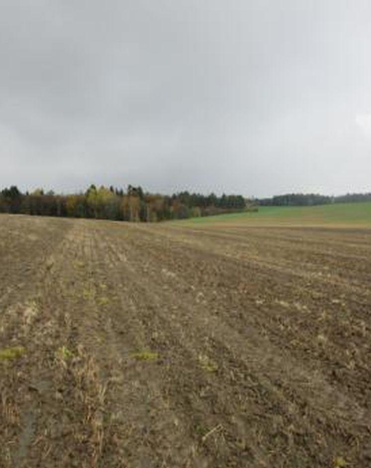
Cropland areas with high erosion risk are left as stubble fields after the harvesting is carried out and throughout the winter. Special regulations in the Morsa catchment (cf. morsa.org) suggest that tillage and fertilizer additions are postponed to the 1st of March at the earliest.
Purpose of the Technology: Reduced tillage is an efficient measure to prevent soil erosion and particle and nutrient
loss from cropland to watercourses. In addition to the protection of soil from water erosion, stubble fields contribute to heighten the organic matter content, which may also increase the
aggregate stability of the soil. it is also possible that higher biological activity may improve the soil structure.
Establishment / maintenance activities and inputs: It is of importance to keep in mind a potential increased amount of weeds and diseases (incl. fungi) when practicing this measure. The soil may also develop a rather dense structure over time if the climate is humid. On areas of low erosion risk, cultivation by autumn harrowing to a depth of 80 to 120 mm, followed by repetitive spring harrowing to a depth of 60 to 100
mm, may be beneficial. The methods are likely to contribute to faster decomposition of
plant material, and to reduce the occurrence of weeds. Direct seeding to stubble fields of young meadow is another method, but requires special equipment and is not very common in this catchment.
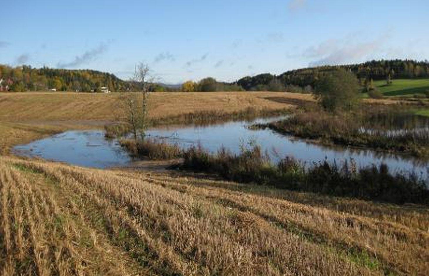
Natural / human environment: The Kråkstad River is mainly situated in Ski commune in Akershus County in South-Eastern parts of Norway. The river catchment is a tributary of the Vansjø-Hobøl watercourse, also known as the Morsa watercourse. The Kråkstad River catchment constitutes a total area of about 22 km², consisting mainly of cropland and forest/woodland. The recipient Vansjø is a eutrophic lake with a former history of algal blooms of toxic cyanobacterias. The lake is both used as a drinking water source and for recreational purposes.
2.3 技术照片
媒体库
2.5 已应用该技术的、本评估所涵盖的国家/地区/地点
国家:
挪威
区域/州/省:
Akershus
有关地点的进一步说明:
Ski
注释:
Boundary points of the Technology area: (59.595, 10.896), (59.611, 10.866), (59.670, 10.869), (59.676, 10.849), (59.717, 10.844), (59.723, 10.893), (59.694, 10.969), (59.655, 10.952), (59.668, 10.904), (59.629, 10.915)
Map
×2.6 实施日期
如果不知道确切的年份,请说明大概的日期:
- 10-50年前
2.7 技术介绍
详细说明该技术是如何引入的:
- 在实验/研究期间
3. SLM技术的分类
3.2 应用该技术的当前土地利用类型

农田
- 一年一作
主要农作物(经济作物及粮食作物):
Major cash crop: Small grains
注释:
Major land use problems (compiler’s opinion): Erosion, flooding and landslides, eutrophication of rivers and lakes
Major land use problems (land users’ perception): Increased usage of pesticides and reduced production
Future (final) land use (after implementation of SLM Technology): Cropland: Ca: Annual cropping
如果由于技术的实施而导致土地用途发生变化,则在技术实施前说明土地利的用途。:
Cropland: Ca: Annual cropping
3.3 有关土地利用的更多信息
该技术所应用土地的供水:
- 雨养
每年的生长季节数:
- 1
具体说明:
Longest growing period in days: 135Longest growing period from month to month: May 1 to mid-September
3.4 该技术所属的SLM组
- 最小的土壤扰动
3.5 技术传播
注释:
Total area covered by the SLM Technology is 4.3 m2.
3.6 包含该技术的可持续土地管理措施

农艺措施
- A1:植被和土壤覆盖层
- A2:有机质/土壤肥力
注释:
Main measures: agronomic measures
Type of agronomic measures: minimum tillage
3.7 该技术强调的主要土地退化类型

土壤水蚀
- Wt:表土流失/地表侵蚀
- Wg:冲沟侵蚀/沟蚀

水质恶化
- Hp:地表水水质下降
注释:
Main type of degradation addressed: Wt: loss of topsoil / surface erosion
Secondary types of degradation addressed: Wg: gully erosion / gullying, Hp: decline of surface water quality
Main causes of degradation: soil management, Heavy / extreme rainfall (intensity/amounts), governance / institutional
Secondary causes of degradation: deforestation / removal of natural vegetation (incl. forest fires), disturbance of water cycle (infiltration / runoff), change of seasonal rainfall, floods, land tenure
3.8 防止、减少或恢复土地退化
具体数量名该技术与土地退化有关的目标:
- 防止土地退化
- 减少土地退化
注释:
Main goals: prevention of land degradation
Secondary goals: mitigation / reduction of land degradation
4. 技术规范、实施活动、投入和成本
4.1 该技术的技术图纸
作者:
Kamilla Skaalsveen
4.2 技术规范/技术图纸说明
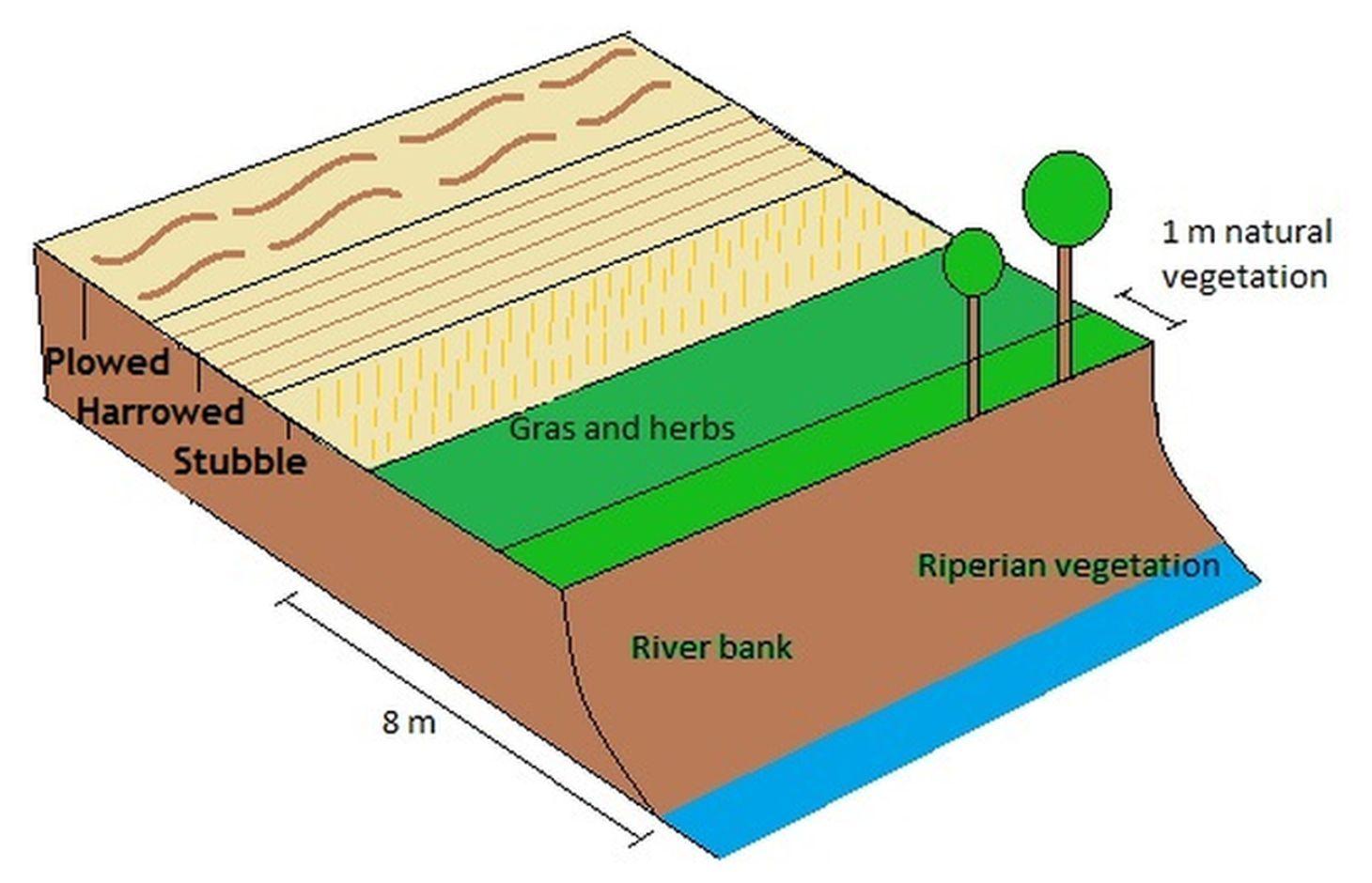
A technical drawing of how a field may be divided into sections of reduced tilling (harrowed and stubble field) on high and moderate erosion risk areas, while it may be plowed on lower risk areas.
Technical knowledge required for field staff / advisors: low
Technical knowledge required for land users: low
Main technical functions: control of raindrop splash, control of dispersed runoff: retain / trap, control of concentrated runoff: impede / retard, improvement of ground cover, sediment retention / trapping, sediment harvesting
Secondary technical functions: control of dispersed runoff: impede / retard, increase of surface roughness, improvement of topsoil structure (compaction), increase in organic matter, increase of infiltration, improvement of water quality, buffering / filtering water, increase of biomass (quantity)
Minimum tillage
Material/ species: Stubble field, harrowing etc.
Remarks: Dependent on erosion risk classes
4.4 技术建立活动
注释:
No initial investement
4.6 维护/经常性活动
注释:
The measure does not lead to any additional expenses for the land user
4.8 影响成本的最重要因素
描述影响成本的最决定性因素:
The measure does not lead to any additional costs for the land user
5. 自然和人文环境
5.1 气候
年降雨量
- < 250毫米
- 251-500毫米
- 501-750毫米
- 751-1,000毫米
- 1,001-1,500毫米
- 1,501-2,000毫米
- 2,001-3,000毫米
- 3,001-4,000毫米
- > 4,000毫米
农业气候带
- 半湿润
- 半干旱
Thermal climate class: temperate
Thermal climate class: boreal
5.2 地形
平均坡度:
- 水平(0-2%)
- 缓降(3-5%)
- 平缓(6-10%)
- 滚坡(11-15%)
- 崎岖(16-30%)
- 陡峭(31-60%)
- 非常陡峭(>60%)
地形:
- 高原/平原
- 山脊
- 山坡
- 山地斜坡
- 麓坡
- 谷底
垂直分布带:
- 0-100 m a.s.l.
- 101-500 m a.s.l.
- 501-1,000 m a.s.l.
- 1,001-1,500 m a.s.l.
- 1,501-2,000 m a.s.l.
- 2,001-2,500 m a.s.l.
- 2,501-3,000 m a.s.l.
- 3,001-4,000 m a.s.l.
- > 4,000 m a.s.l.
5.3 土壤
平均土层深度:
- 非常浅(0-20厘米)
- 浅(21-50厘米)
- 中等深度(51-80厘米)
- 深(81-120厘米)
- 非常深(> 120厘米)
土壤质地(表土):
- 细粒/重质(粘土)
表土有机质:
- 中(1-3%)
如有可能,附上完整的土壤描述或具体说明可用的信息,例如土壤类型、土壤酸碱度、阳离子交换能力、氮、盐度等。:
Soil fertility is medium-high
Soil drainage/infiltration is poor
Soil water storage capacity is very low-low
5.4 水资源可用性和质量
地下水位表:
< 5米
地表水的可用性:
好
水质(未处理):
仅供农业使用(灌溉)
5.5 生物多样性
物种多样性:
- 低
5.6 应用该技术的土地使用者的特征
生产系统的市场定位:
- 混合(生计/商业
- 商业/市场
非农收入:
- > 收入的50%
相对财富水平:
- 平均水平
- 丰富
个人或集体:
- 个人/家庭
机械化水平:
- 机械化/电动
性别:
- 女人
- 男人
说明土地使用者的其他有关特征:
Land users applying the Technology are mainly common / average land users
Population density: < 10 persons/km2
Annual population growth: < 0.5%
10% of the land users are rich and own 10% of the land.
90% of the land users are average wealthy and own 90% of the land.
5.7 应用该技术的土地使用者拥有或租用的平均土地面积
- < 0.5 公顷
- 0.5-1 公顷
- 1-2 公顷
- 2-5公顷
- 5-15公顷
- 15-50公顷
- 50-100公顷
- 100-500公顷
- 500-1,000公顷
- 1,000-10,000公顷
- > 10,000公顷
这被认为是小规模、中规模还是大规模的(参照当地实际情况)?:
- 中等规模的
5.8 土地所有权、土地使用权和水使用权
土地所有权:
- 个人,有命名
土地使用权:
- 个人
用水权:
- 自由进入(无组织)
5.9 进入服务和基础设施的通道
健康:
- 贫瘠
- 适度的
- 好
教育:
- 贫瘠
- 适度的
- 好
技术援助:
- 贫瘠
- 适度的
- 好
就业(例如非农):
- 贫瘠
- 适度的
- 好
市场:
- 贫瘠
- 适度的
- 好
能源:
- 贫瘠
- 适度的
- 好
道路和交通:
- 贫瘠
- 适度的
- 好
饮用水和卫生设施:
- 贫瘠
- 适度的
- 好
金融服务:
- 贫瘠
- 适度的
- 好
6. 影响和结论性说明
6.1 该技术的现场影响
社会经济效应
生产
作物生产
生产故障风险
土地管理
收入和成本
农业收入
工作量
社会文化影响
SLM/土地退化知识
Improved livelihoods and human well-being
生态影响
水循环/径流
水质
地表径流
蒸发
土壤
土壤覆盖层
土壤流失
土壤压实
生物多样性:植被、动物
生物量/地上C
有益物种
6.2 该技术的场外影响已经显现
下游洪水
下游淤积
对公共/私人基础设施的破坏
6.3 技术对渐变气候以及与气候相关的极端情况/灾害的暴露和敏感性(土地使用者认为的极端情况/灾害)
渐变气候
渐变气候
| 季节 | 气候变化/极端天气的类型 | 该技术是如何应对的? | |
|---|---|---|---|
| 年温度 | 增加 | 好 |
气候有关的极端情况(灾害)
气象灾害
| 该技术是如何应对的? | |
|---|---|
| 局地暴雨 | 好 |
| 局地风暴 | 好 |
气候灾害
| 该技术是如何应对的? | |
|---|---|
| 干旱 | 好 |
水文灾害
| 该技术是如何应对的? | |
|---|---|
| 比较和缓的(河道)洪水 | 好 |
其他气候相关的后果
其他气候相关的后果
| 该技术是如何应对的? | |
|---|---|
| 缩短生长期 | 好 |
6.4 成本效益分析
技术收益与技术建立成本相比如何(从土地使用者的角度看)?
短期回报:
消极
长期回报:
轻度消极
技术收益与技术维护成本/经常性成本相比如何(从土地使用者的角度看)?
短期回报:
轻度消极
长期回报:
轻度消极
6.5 技术采用
注释:
Comments on acceptance with external material support: Local regulations determine that farmers only receive subsidies per production area along with financial grants if they implement the technology.
There is no trend towards spontaneous adoption of the Technology
6.7 该技术的优点/长处/机会
| 编制者或其他关键资源人员认为的长处/优势/机会 |
|---|
|
Reduced soil loss and erosion How can they be sustained / enhanced? maintain the regulation that land in high erosion classes should not be plowed in autumn |
6.8 技术的弱点/缺点/风险及其克服方法
| 编制者或其他关键资源人员认为的弱点/缺点/风险 | 如何克服它们? |
|---|---|
| Higher demand for pesticides | Autumn and spring harrowing |
链接和模块
全部展开 全部收起链接
Regional Environmental program [挪威]
Regulations and financial grants for reduction of pollution and promotion of the cultural landscape.
- 编制者: Kamilla Skaalsveen
模块
无模块