Reduced tillage [ນໍເວ]
- ການສ້າງ:
- ປັບປູງ:
- ຜູ້ສັງລວມຂໍ້ມູນ: Kamilla Skaalsveen
- ບັນນາທິການ: –
- ຜູ້ທົບທວນຄືນ: Fabian Ottiger
Redusert jordarbeiding
technologies_1245 - ນໍເວ
ເບິ່ງພາກສ່ວນ
ຂະຫຍາຍທັງໝົດ ຍຸບທັງໝົດ1. ຂໍ້ມູນທົ່ວໄປ
1.2 ຂໍ້ມູນ ການຕິດຕໍ່ພົວພັນ ຂອງບຸກຄົນທີ່ສໍາຄັນ ແລະ ສະຖາບັນ ທີ່ມີສ່ວນຮ່ວມ ໃນການປະເມີນເອກກະສານ ເຕັກໂນໂລຢີ
ຊື່ໂຄງການ ທີ່ອໍານວຍຄວາມສະດວກ ໃນການສ້າງເອກກະສານ/ປະເມີນ ເຕັກໂນໂລຢີ (ຖ້າກ່ຽວຂ້ອງ)
Preventing and Remediating degradation of soils in Europe through Land Care (EU-RECARE )ຊື່ສະຖາບັນ (ຫຼາຍສະຖາບັນ) ທີ່ອໍານວຍຄວາມສະດວກ ໃນການສ້າງເອກກະສານ / ປະເມີນ ເຕັກໂນໂລຢີ (ຖ້າກ່ຽວຂ້ອງ)
Norwegian Institute for Agricultural and Environme (Norwegian Institute for Agricultural and Environme) - ນໍເວ1.3 ເງື່ອນໄຂ ກ່ຽວກັບ ການນໍາໃຊ້ຂໍ້ມູນເອກະສານ ທີ່ສ້າງຂື້ນ ໂດຍຜ່ານ ອົງການພາບລວມຂອງໂລກ ທາງດ້ານແນວທາງ ແລະ ເຕັກໂນໂລຢີ ຂອງການອານຸລັກ ທໍາມະຊາດ (WOCAT)
ເມື່ອໃດທີ່ໄດ້ສັງລວມຂໍ້ມູນ (ຢູ່ພາກສະໜາມ)?
14/08/2014
ຜູ້ປ້ອນຂໍ້ມູນ ແລະ ບຸກຄົນສຳຄັນ ທີ່ໃຫ້ຂໍ້ມູນ (ຫຼາຍ) ຍິນຍອມ ຕາມເງື່ອນໄຂ ໃນການນຳໃຊ້ຂໍ້ມູນ ເພື່ອສ້າງເປັນເອກກະສານຂອງ WOCAT:
ແມ່ນ
1.5 ອ້າງອີງເຖິງແບບສອບສອບຖາມ (ຫຼາຍ) ທາງດ້ານວິທີການ ໃນການຄຸ້ມຄອງ ທີ່ດິນແບບຍືນຍົງ

Regional Environmental program [ນໍເວ]
Regulations and financial grants for reduction of pollution and promotion of the cultural landscape.
- ຜູ້ສັງລວມຂໍ້ມູນ: Kamilla Skaalsveen
2. ການອະທິບາຍ ເຕັກໂນໂລຢີ ຂອງການຄຸ້ມຄອງ ທີ່ດິນແບບຍືນຍົງ
2.1 ຄໍາອະທິບາຍສັ້ນຂອງ ເຕັກໂນໂລຢີ
ການກຳໜົດຄວາມໝາຍ ຂອງເຕັກໂນໂລຢີ:
Reduced tillage of cropland areas to decrease erosion by water and soil loss.
2.2 ການອະທິບາຍ ລາຍລະອຽດ ຂອງເຕັກໂນໂລຢີ
ການພັນລະນາ:
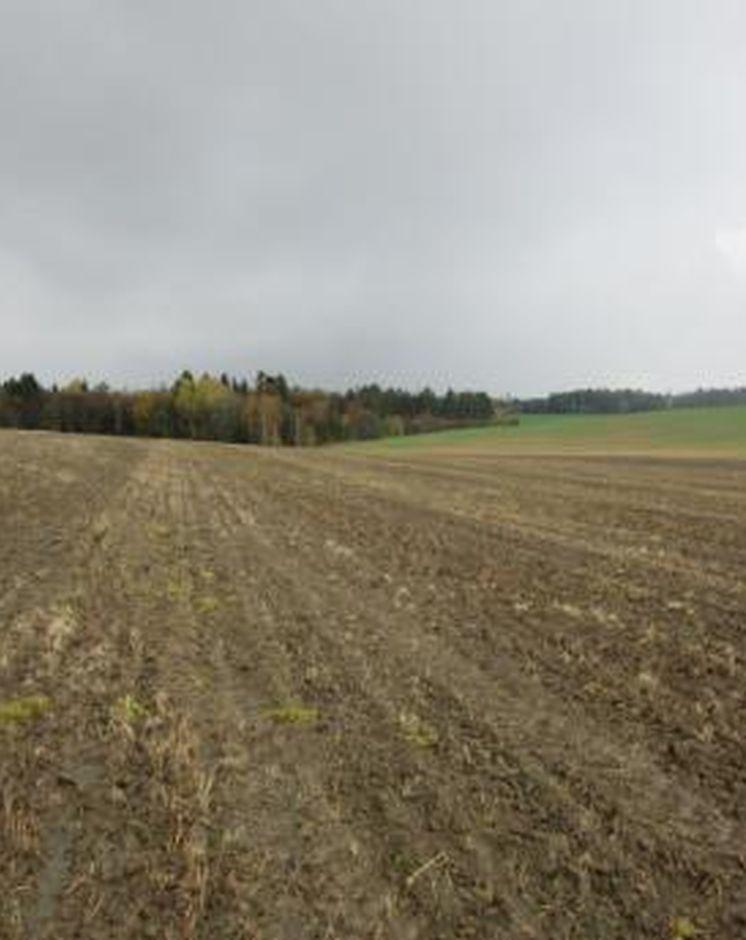
Cropland areas with high erosion risk are left as stubble fields after the harvesting is carried out and throughout the winter. Special regulations in the Morsa catchment (cf. morsa.org) suggest that tillage and fertilizer additions are postponed to the 1st of March at the earliest.
Purpose of the Technology: Reduced tillage is an efficient measure to prevent soil erosion and particle and nutrient
loss from cropland to watercourses. In addition to the protection of soil from water erosion, stubble fields contribute to heighten the organic matter content, which may also increase the
aggregate stability of the soil. it is also possible that higher biological activity may improve the soil structure.
Establishment / maintenance activities and inputs: It is of importance to keep in mind a potential increased amount of weeds and diseases (incl. fungi) when practicing this measure. The soil may also develop a rather dense structure over time if the climate is humid. On areas of low erosion risk, cultivation by autumn harrowing to a depth of 80 to 120 mm, followed by repetitive spring harrowing to a depth of 60 to 100
mm, may be beneficial. The methods are likely to contribute to faster decomposition of
plant material, and to reduce the occurrence of weeds. Direct seeding to stubble fields of young meadow is another method, but requires special equipment and is not very common in this catchment.
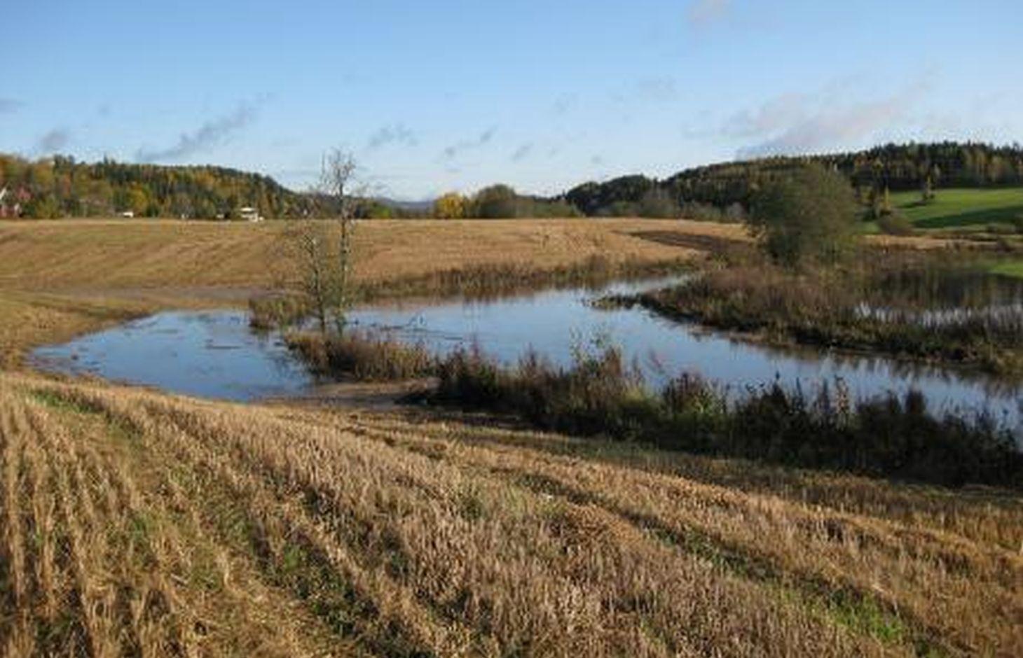
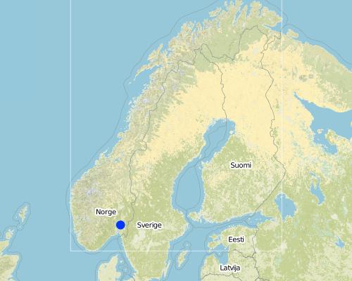
Natural / human environment: The Kråkstad River is mainly situated in Ski commune in Akershus County in South-Eastern parts of Norway. The river catchment is a tributary of the Vansjø-Hobøl watercourse, also known as the Morsa watercourse. The Kråkstad River catchment constitutes a total area of about 22 km², consisting mainly of cropland and forest/woodland. The recipient Vansjø is a eutrophic lake with a former history of algal blooms of toxic cyanobacterias. The lake is both used as a drinking water source and for recreational purposes.
2.3 ຮູບພາບຂອງເຕັກໂນໂລຢີ
ສື່ຮູບພາບ
2.5 ປະເທດ / ເຂດ / ສະຖານທີ່ບ່ອນທີ່ ເຕັກໂນໂລຢີ ໄດ້ຮັບການນໍາໃຊ້ ແລະ ທີ່ຖືກປົກຄຸມດ້ວຍການປະເມີນຜົນ
ປະເທດ:
ນໍເວ
ພາກພື້ນ / ລັດ / ແຂວງ:
Akershus
ຂໍ້ມູນເພີ່ມເຕີມຂອງສະຖານທີ່:
Ski
ຄວາມຄິດເຫັນ:
Boundary points of the Technology area: (59.595, 10.896), (59.611, 10.866), (59.670, 10.869), (59.676, 10.849), (59.717, 10.844), (59.723, 10.893), (59.694, 10.969), (59.655, 10.952), (59.668, 10.904), (59.629, 10.915)
Map
×2.6 ວັນທີໃນການຈັດຕັ້ງປະຕິບັດ
ຖ້າຫາກວ່າ ບໍ່ຮູ້ຈັກ ປີທີ່ຊັດເຈນ ແມ່ນໃຫ້ປະມານ ວັນທີເອົາ:
- 10-50 ປີ ຜ່ານມາ
2.7 ການນໍາສະເໜີ ເຕັກໂນໂລຢີ
ໃຫ້ລະບຸ ເຕັກໂນໂລຢີ ໄດ້ຖືກຈັດຕັ້ງປະຕິບັດຄືແນວໃດ?
- ໃນໄລຍະການທົດລອງ / ການຄົ້ນຄວ້າ
3. ການໃຈ້ແຍກ ເຕັກໂນໂລຢີ ໃນການຄຸ້ມຄອງ ດິນແບບຍືນຍົງ
3.2 ປະເພດການນໍາໃຊ້ທີ່ດິນ ໃນປະຈຸບັນ() ທີ່ເຕັກໂນໂລຢີ ໄດ້ຖືກນໍາໃຊ້

ດິນທີ່ປູກພືດ
- ການປູກພືດປະຈໍາປີ
ການປູກພືດຫຼັກ (ທີ່ສາມາດສ້າງລັບຮັບ ເປັນເງິນສົດ ແລະ ເປັນພືດສະບຽງອາຫານ):
Major cash crop: Small grains
ຄວາມຄິດເຫັນ:
Major land use problems (compiler’s opinion): Erosion, flooding and landslides, eutrophication of rivers and lakes
Major land use problems (land users’ perception): Increased usage of pesticides and reduced production
Future (final) land use (after implementation of SLM Technology): Cropland: Ca: Annual cropping
ຖ້າຫາກວ່າ ການນໍາໃຊ້ທີ່ດິນ ມີການປ່ຽນແປງ ໃນເວລາ ຈັດຕັ້ງປະຕິບັດ ເຕັກໂນໂລຢີ, ແມ່ນໃຫ້ລະບຸວ່າ ດິນພື້ນທີ່ດັ່ງກ່າວ ເຄີຍເປັນດິນປະເພດໃດ ກ່ອນການຈັດຕັ້ງປະຕິບັດ ເຕັກໂນໂລຢີ:
Cropland: Ca: Annual cropping
3.3 ຂໍ້ມູນເພີ່ມເຕີມກ່ຽວກັບການນໍາໃຊ້ທີ່ດິນ
ການສະໜອງນໍ້າ ໃນພື້ນທີ່ ທີ່ໄດ້ນໍາໃຊ້ ເຕັກໂນໂລຢີ:
- ນໍ້າຝົນ
ຈໍານວນ ລະດູການ ປູກໃນປີໜຶ່ງ:
- 1
ລະບຸ ຊະນິດ:
Longest growing period in days: 135Longest growing period from month to month: May 1 to mid-September
3.4 ການນໍາໃຊ້ເຕັກໂນໂລຢີ ທີ່ຢູ່ໃນກຸ່ມການຄຸ້ມຄອງ ທີ່ດິນແບບຍືນຍົງ
- ການຫຼຸດຜ່ອນ ກິດຈະກໍາ ທີ່ລົບກວນດິນ
3.5 ການຂະຫຍາຍເຕັກໂນໂລຢີ
ຄວາມຄິດເຫັນ:
Total area covered by the SLM Technology is 4.3 m2.
3.6 ມາດຕະການ ການຄຸ້ມຄອງ ທີ່ດິນແບບຍືນຍົງ ປະກອບດ້ວຍ ເຕັກໂນໂລຢີ

ມາດຕະການ ທາງການກະສິກໍາ
- A1: ພືດ / ການປົກຫຸ້ມຂອງດິນ
- A2: ອິນຊີວັດຖຸ ຫຼື ຄວາມອຸດົມສົມບູນໃນດິນ
ຄວາມຄິດເຫັນ:
Main measures: agronomic measures
Type of agronomic measures: minimum tillage
3.7 ປະເພດດິນເຊື່ອມໂຊມ ຫຼັກທີ່ໄດ້ນໍາໃຊ້ ເຕັກໂນໂລຢີ

ດິນເຊາະເຈື່ອນ ໂດຍນໍ້າ
- Wt: ການສູນເສຍຊັ້ນໜ້າດິນ / ການເຊາະເຈື່ອນຜິວໜ້າດິນ
- Wg: ການເຊາະເຈື່ອນຮ່ອງນ້ຳ / ຫ້ວຍ

ການເຊື່ອມໂຊມ ຂອງນໍ້າ
- Hp: ຄຸນນະພາບ ຂອງນ້ຳຊັ້ນໜ້າດິນຫຼຸດລົງ
ຄວາມຄິດເຫັນ:
Main type of degradation addressed: Wt: loss of topsoil / surface erosion
Secondary types of degradation addressed: Wg: gully erosion / gullying, Hp: decline of surface water quality
Main causes of degradation: soil management, Heavy / extreme rainfall (intensity/amounts), governance / institutional
Secondary causes of degradation: deforestation / removal of natural vegetation (incl. forest fires), disturbance of water cycle (infiltration / runoff), change of seasonal rainfall, floods, land tenure
3.8 ການປ້ອງກັນ, ການຫຼຸດຜ່ອນ, ຫຼືການຟື້ນຟູຂອງການເຊື່ອມໂຊມຂອງດິນ
ໃຫ້ລະບຸ ເປົ້າໝາຍ ເຕັກໂນໂລຢີ ທີ່ພົວພັນ ກັບຄວາມເຊື່ອມໂຊມຂອງດິນ:
- ປ້ອງກັນການເຊື່ອມໂຊມຂອງດິນ
- ຫຼຸດຜ່ອນການເຊື່ອມໂຊມຂອງດິນ
ຄວາມຄິດເຫັນ:
Main goals: prevention of land degradation
Secondary goals: mitigation / reduction of land degradation
4. ຂໍ້ກໍາໜົດ, ກິດຈະກໍາການປະຕິບັດ, ວັດຖຸດິບ, ແລະຄ່າໃຊ້ຈ່າຍ
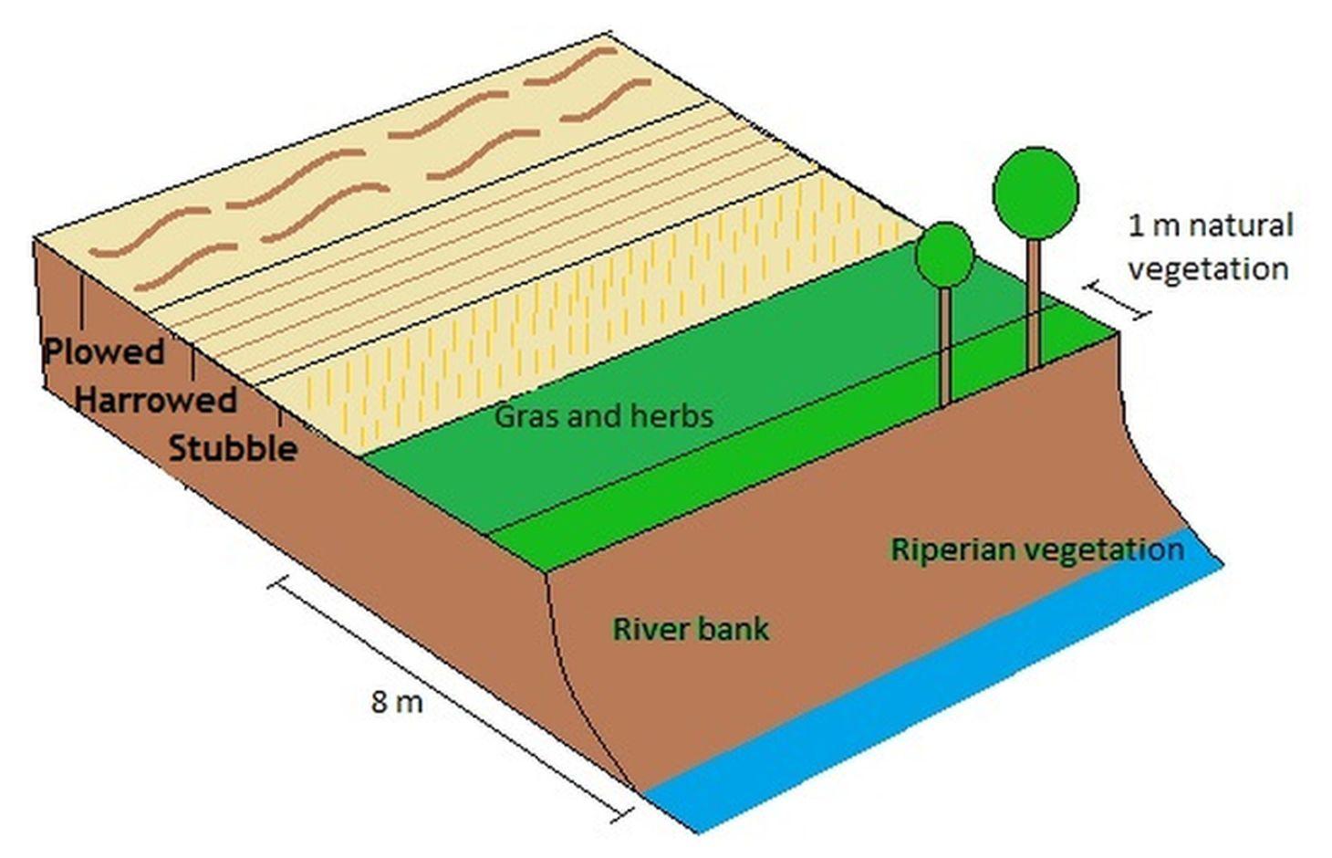
4.1 ເຕັກນິກ ໃນການແຕ້ມແຜນວາດ ເຕັກໂນໂລຢີ
ຜູ້ຂຽນ:
Kamilla Skaalsveen
4.2 ການແຕ້ມແຜນວາດອະທິບາຍເຕັກນິກ
A technical drawing of how a field may be divided into sections of reduced tilling (harrowed and stubble field) on high and moderate erosion risk areas, while it may be plowed on lower risk areas.
Technical knowledge required for field staff / advisors: low
Technical knowledge required for land users: low
Main technical functions: control of raindrop splash, control of dispersed runoff: retain / trap, control of concentrated runoff: impede / retard, improvement of ground cover, sediment retention / trapping, sediment harvesting
Secondary technical functions: control of dispersed runoff: impede / retard, increase of surface roughness, improvement of topsoil structure (compaction), increase in organic matter, increase of infiltration, improvement of water quality, buffering / filtering water, increase of biomass (quantity)
Minimum tillage
Material/ species: Stubble field, harrowing etc.
Remarks: Dependent on erosion risk classes
4.4 ການສ້າງຕັ້ງກິດຈະກໍາ
ຄວາມຄິດເຫັນ:
No initial investement
4.6 ບໍາລຸງຮັກສາ / ແຜນຈັດຕັ້ງປະຕິບັດ ກິດຈະກໍາ
ຄວາມຄິດເຫັນ:
The measure does not lead to any additional expenses for the land user
4.8 ປັດໄຈ ທີ່ສໍາຄັນ ທີ່ສົ່ງຜົນກະທົບ ຕໍ່ຄ່າໃຊ້ຈ່າຍ
ໃຫ້ອະທິບາຍ ປັດໃຈ ທີ່ສົ່ງຜົນກະທົບ ຕໍ່ຕົ້ນທຶນ ໃນການຈັດຕັ້ງປະຕິບັດ:
The measure does not lead to any additional costs for the land user
5. ສະພາບແວດລ້ອມທໍາມະຊາດ ແລະ ມະນຸດ
5.1 ອາກາດ
ປະລິມານນໍ້າຝົນປະຈໍາປີ
- < 250 ມີລິແມັດ
- 251-500 ມີລິແມັດ
- 501-750 ມີລິແມັດ
- 751-1,000 ມີລິແມັດ
- 1,001-1,500 ມີລິແມັດ
- 1,501-2,000 ມີລິແມັດ
- 2,001-3,000 ມີລິແມັດ
- 3,001-4,000 ມີລິແມັດ
- > 4,000 ມີລິແມັດ
ເຂດສະພາບອາກາດກະສິກໍາ
- ເຄີ່ງຄວາມຊຸ່ມ
- ເຄິ່ງແຫ້ງແລ້ງ
Thermal climate class: temperate
Thermal climate class: boreal
5.2 ພູມິປະເທດ
ຄ່າສະເລ່ຍ ຄວາມຄ້ອຍຊັນ:
- ພື້ນທີ່ຮາບພຽງ (0-2%)
- ອ່ອນ (3-5 %)
- ປານກາງ (6-10 %)
- ມ້ວນ (11-15 %)
- ເນີນ(16-30%)
- ໍຊັນ (31-60%)
- ຊັນຫຼາຍ (>60%)
ຮູບແບບຂອງດິນ:
- ພູພຽງ / ທົ່ງພຽງ
- ສັນພູ
- ເປີ້ນພູ
- ເນີນພູ
- ຕີນພູ
- ຮ່ອມພູ
ເຂດລະດັບສູງ:
- 0-100 ແມັດ a.s.l.
- 101-500 ແມັດ a.s.l.
- 501-1,000 ແມັດ a.s.l.
- 1,001-1,500 ແມັດ a.s.l.
- 1,501-2,000 ແມັດ a.s.l.
- 2,001-2,500 ແມັດ a.s.l.
- 2,501-3,000 ແມັດ a.s.l.
- 3,001-4,000 ແມັດ a.s.l.
- > 4,000 ແມັດ a.s.l.
5.3 ດິນ
ຄວາມເລິກ ຂອງດິນສະເລ່ຍ:
- ຕື້ນຫຼາຍ (0-20 ຊັງຕີແມັດ)
- ຕື້ນ (21-50 ຊຕມ)
- ເລີກປານກາງ (51-80 ຊຕມ)
- ເລິກ (81-120 ຊມ)
- ເລິກຫຼາຍ (> 120 cm)
ເນື້ອດິນ (ໜ້າດິນ):
- ບາງລະອຽດ / ໜັກ (ໜຽວ)
ຊັ້ນອິນຊີວັດຖຸ ເທິງໜ້າດິນ:
- ປານກາງ (1-3 %)
ຖ້າເປັນໄປໄດ້ ແມ່ນໃຫ້ຕິດຄັດ ການພັນລະນາດິນ ຫຼື ຂໍ້ມູນສະເພາະຂອງດິນ, ຕົວຢ່າງ, ຄຸນລັກສະນະ ປະເພດຂອງດິນ, ຄ່າຄວາມເປັນກົດ / ເປັນດ່າງຂອງດິນ, ສານອາຫານ, ດິນເຄັມ ແລະ ອື່ນໆ.
Soil fertility is medium-high
Soil drainage/infiltration is poor
Soil water storage capacity is very low-low
5.4 ມີນໍ້າ ແລະ ຄຸນນະພາບ
ລະດັບ ນໍ້າໃຕ້ດິນ:
< 5 ແມັດ
ການມີນໍ້າ ເທິງໜ້າດິນ:
ດີ
ຄຸນນະພາບນໍ້າ (ບໍ່ມີການບໍາບັດ):
ນຳໃຊ້ເຂົ້າໃນການຜະລິດກະສິກໍາພຽງຢ່າງດຽງ (ຊົນລະປະທານ)
5.5 ຊີວະນາໆພັນ
ຄວາມຫຼາກຫຼາຍ ທາງສາຍພັນ:
- ຕໍ່າ
5.6 ຄຸນລັກສະນະ ຂອງຜູ້ນໍາໃຊ້ທີ່ດິນ ທີ່ໄດ້ນໍາໃຊ້ເຕັກໂນໂລຢີ
ລະບົບ ການຕະຫຼາດ ແລະ ຜົນຜະລິດ:
- ປະສົມ (ກຸ້ມຕົນເອງ / ເປັນສິນຄ້າ
- ການຄ້າ / ຕະຫຼາດ
ລາຍຮັບ ທີ່ບໍ່ໄດ້ມາຈາກ ການຜະລິດ ກະສິກໍາ:
- > 50 % ຂອງລາຍຮັບທັງໝົດ
ລະດັບຄວາມຮັ່ງມີ:
- ສະເລ່ຍ
- ຮັ່ງມີ
ບຸກຄົນ ຫຼື ກຸ່ມ:
- ບຸກຄົນ / ຄົວເຮືອນ
ລະດັບ ການຫັນເປັນກົນຈັກ:
- ເຄື່ອງກົນຈັກ
ເພດ:
- ຜູ້ຍິງ
- ຜູ້ຊາຍ
ໃຫ້ລະບຸ ຄຸນລັກສະນະ ຂອງຜູ້ນໍາໃຊ້ທີ່ດິນ:
Land users applying the Technology are mainly common / average land users
Population density: < 10 persons/km2
Annual population growth: < 0.5%
10% of the land users are rich and own 10% of the land.
90% of the land users are average wealthy and own 90% of the land.
5.7 ພື້ນທີ່ສະເລ່ຍຂອງທີ່ດິນ ຫຼື ເຊົ່າໂດຍຜູ້ໃຊ້ທີ່ດິນການນໍາໃຊ້ ເຕັກໂນໂລຢີ
- <0.5 ເຮັກຕາ
- 0.5-1 ເຮັກຕາ
- 1-2 ເຮັກຕາ
- 2-5 ເຮັກຕາ
- 5-15 ເຮັກຕາ
- 15-50 ເຮັກຕາ
- 50-100 ເຮັກຕາ
- 100-500 ເຮັກຕາ
- 500-1,000 ເຮັກຕາ
- 1,000-10,000 ເຮັກຕາ
- > 10,000 ເຮັກຕາ
ຖືໄດ້ວ່າ ເປັນຂະໜາດນ້ອຍ, ກາງ ຫຼື ໃຫຍ່ (ອີງຕາມເງື່ອນໄຂ ສະພາບຄວາມເປັນຈິງ ຂອງທ້ອງຖີ່ນ)? :
- ຂະໜາດກາງ
5.8 ເຈົ້າຂອງທີ່ດິນ, ສິດໃຊ້ທີ່ດິນ, ແລະ ສິດທິການນໍາໃຊ້ນໍ້າ
ເຈົ້າຂອງດິນ:
- ບຸກຄົນ, ທີ່ມີຕໍາແໜ່ງ
ສິດທິ ໃນການນໍາໃຊ້ທີ່ດິນ:
- ບຸກຄົນ
ສິດທິ ໃນການນໍາໃຊ້ນໍ້າ:
- ເປີດກວ້າງ (ບໍ່ມີການຈັດຕັ້ງ)
5.9 ການເຂົ້າເຖິງການບໍລິການ ແລະ ພື້ນຖານໂຄງລ່າງ
ສຸຂະພາບ:
- ທຸກຍາກ
- ປານກາງ
- ດີ
ການສຶກສາ:
- ທຸກຍາກ
- ປານກາງ
- ດີ
ການຊ່ວຍເຫຼືອ ດ້ານວິຊາການ:
- ທຸກຍາກ
- ປານກາງ
- ດີ
ການຈ້າງງານ (ຕົວຢ່າງ, ການເຮັດກິດຈະກໍາອື່ນ ທີ່ບໍ່ແມ່ນ ການຜະລິດກະສິກໍາ):
- ທຸກຍາກ
- ປານກາງ
- ດີ
ຕະຫຼາດ:
- ທຸກຍາກ
- ປານກາງ
- ດີ
ພະລັງງານ:
- ທຸກຍາກ
- ປານກາງ
- ດີ
ຖະໜົນຫົນທາງ ແລະ ການຂົນສົ່ງ:
- ທຸກຍາກ
- ປານກາງ
- ດີ
ການດື່ມນໍ້າ ແລະ ສຸຂາພິບານ:
- ທຸກຍາກ
- ປານກາງ
- ດີ
ການບໍລິການ ທາງດ້ານການເງິນ:
- ທຸກຍາກ
- ປານກາງ
- ດີ
6. ຜົນກະທົບ ແລະ ລາຍງານສະຫຼຸບ
6.1 ການສະແດງຜົນກະທົບ ພາຍໃນພື້ນທີ່ ທີ່ໄດ້ຈັດຕັ້ງປະຕິບັດ ເຕັກໂນໂລຢີ
ຜົນກະທົບທາງເສດຖະກິດສັງຄົມ
ການຜະລິດ
ການຜະລິດພືດ
ຄວາມສ່ຽງ ຕໍ່ຜົນຜະລິດ
ການຈັດການຄຸ້ມຄອງທີ່ດິນ
ລາຍໄດ້ ແລະ ຄ່າໃຊ້ຈ່າຍ
ລາຍຮັບ ຈາກການຜະລີດ
ມີວຽກໜັກ
ຜົນກະທົບດ້ານວັດທະນາທໍາສັງຄົມ
ຄວາມຮູ້ກ່ຽວກັບ ການຄຸ້ມຄອງ ທີ່ດິນແບບຍືນຍົງ / ການເຊື່ອມໂຊມຂອງດິນ
Improved livelihoods and human well-being
ຜົນກະທົບຕໍ່ລະບົບນິເວດ
ວົງຈອນນໍ້າ / ນໍ້າ
ຄຸນນະພາບນໍ້າ
ການໄຫຼ ຂອງນໍ້າໜ້າດິນ
ການລະເຫີຍອາຍ
ດິນ
ການປົກຄຸມຂອງດິນ
ການສູນເສຍດິນ
ການອັດແໜ້ນຂອງດິນ
ຊີວະນານາພັນ: ສັດ, ພືດ
ມວນຊີວະພາບ / ຢູ່ເທິງຊັ້ນດິນ C
ຊະນິດທີ່ເປັນປະໂຫຍດ
6.2 ຜົນກະທົບທາງອ້ອມ ຈາກການນໍາໃຊ້ເຕັກໂນໂລຢີ
ນໍ້າຖ້ວມຢູ່ເຂດລຸ່ມນໍ້າ
ການທັບຖົມ ຂອງດິນຕະກອນ ຢູ່ເຂດລຸ່ມນໍ້າ
ຄວາມເສຍຫາຍ ກ່ຽວກັບພື້ນຖານໂຄງລ່າງ ສາທາລະນະ / ເອກກະຊົນ
6.3 ການປ້ອງກັນ ແລະ ຄວາມບອບບາງ ຂອງເຕັກໂນໂລຢິ ໃນການປ່ຽນແປງສະພາບດິນຟ້າອາກາດ ແລະ ກ່ຽວຂ້ອງກັບອາກາດທີ່ມີການປ່ຽນແປງທີ່ຮຸນແຮງ / ໄພພິບັດທາງທໍາມະຊາດ (ຮັບຮູ້ໄດ້ໂດຍຜູ້ນໍາໃຊ້ທີ່ດິນ)
ການປ່ຽນແປງດິນຟ້າອາກາດ ເທື່ອລະກ້າວ
ການປ່ຽນແປງດິນຟ້າອາກາດ ເທື່ອລະກ້າວ
| ລະດູການ | ຮູບແບບ ການປ່ຽນແປງດິນຟ້າອາກາດ / ທີ່ຮ້າຍແຮງ | ການນໍາໃຊ້ ເຕັກໂນໂລຢີ ສາມາດ ຮັບມື ໄດ້ຄືແນວໃດ? | |
|---|---|---|---|
| ອຸນຫະພູມປະຈໍາປີ | ເພີ່ມຂື້ນ | ດີ |
ອາກາດ ທີ່ກ່ຽວພັນກັບຄວາມຮຸນແຮງ (ໄພພິບັດທາງທໍາມະຊາດ)
ໄພພິບັດທາງອຸຕຸນິຍົມ
| ການນໍາໃຊ້ ເຕັກໂນໂລຢີ ສາມາດ ຮັບມື ໄດ້ຄືແນວໃດ? | |
|---|---|
| ພະຍຸຝົນ | ດີ |
| ພາຍຸລົມທ້ອງຖິ່ນ | ດີ |
ໄພພິບັດທາງພູມອາກາດ
| ການນໍາໃຊ້ ເຕັກໂນໂລຢີ ສາມາດ ຮັບມື ໄດ້ຄືແນວໃດ? | |
|---|---|
| ແຫ້ງແລ້ງ | ດີ |
ໄພພິບັດທາງອຸທົກກະສາກ
| ການນໍາໃຊ້ ເຕັກໂນໂລຢີ ສາມາດ ຮັບມື ໄດ້ຄືແນວໃດ? | |
|---|---|
| ໂດຍທົ່ວໄປ (ແມ່ນໍ້າ) ນໍ້າຖ້ວມ | ດີ |
ຜົນສະທ້ອນສະພາບອາກາດອື່ນໆທີ່ກ່ຽວຂ້ອງ
ຜົນສະທ້ອນສະພາບອາກາດອື່ນໆທີ່ກ່ຽວຂ້ອງ
| ການນໍາໃຊ້ ເຕັກໂນໂລຢີ ສາມາດ ຮັບມື ໄດ້ຄືແນວໃດ? | |
|---|---|
| ໄລຍະເວລາການຂະຫຍາຍຕົວຫຼຸດລົງ | ດີ |
6.4 ການວິເຄາະຕົ້ນທຶນ ແລະ ຜົນປະໂຫຍດ
ຈະເຮັດປະໂຫຍດເພື່ອປຽບທຽບກັບຄ່າໃຊ້ຈ່າຍກັບສິ່ງກໍ່ສ້າງ (ຈາກທັດສະນະຂອງຜູ້ນຳໃຊ້ທີ່ດິນ) ໄດ້ແນວໃດ?
ຜົນຕອບແທນ ໃນໄລຍະສັ້ນ:
ຜົນກະທົບທາງລົບ
ຜົນຕອບແທນ ໃນໄລຍະຍາວ:
ຜົນກະທົບທາງລົບເລັກນ້ອຍ
ຈະໄດ້ຮັບຜົນປະໂຫຍດເມື່ອປຽບທຽບກັບ / ຄ່າໃຊ້ຈ່າຍໃນການບຳລຸງຮັກສາທີເ່ກີດຂື້ນອິກ (ຈາກທັດສະນະຄະຕິຂອງຜູ້ນຳໃຊ້ທີ່ດິນ) ໄດ້ແນວໃດ?
ຜົນຕອບແທນ ໃນໄລຍະສັ້ນ:
ຜົນກະທົບທາງລົບເລັກນ້ອຍ
ຜົນຕອບແທນ ໃນໄລຍະຍາວ:
ຜົນກະທົບທາງລົບເລັກນ້ອຍ
6.5 ການປັບຕົວຮັບເອົາເຕັກໂນໂລຢີ
ຄວາມຄິດເຫັນ:
Comments on acceptance with external material support: Local regulations determine that farmers only receive subsidies per production area along with financial grants if they implement the technology.
There is no trend towards spontaneous adoption of the Technology
6.7 ຈຸດແຂງ / ຂໍ້ດີ / ໂອກາດ ໃນການນໍາໃຊ້ ເຕັກໂນໂລຢີ
| ຈຸດແຂງ / ຈຸດດີ / ໂອກາດ ຈາກທັດສະນະຂອງຜູ້ປ້ອນຂໍ້ມູນ ຫຼື ບຸກຄົນສຳຄັນ |
|---|
|
Reduced soil loss and erosion How can they be sustained / enhanced? maintain the regulation that land in high erosion classes should not be plowed in autumn |
6.8 ຈຸດອ່ອນ / ຂໍ້ເສຍ / ຄວາມສ່ຽງ ໃນການນໍາໃຊ້ ເຕັກໂນໂລຢີ ແລະ ວິທີການແກ້ໄຂບັນຫາ
| ຈຸດອ່ອນ/ຂໍ້ບົກຜ່ອງ/ຄວາມສ່ຽງ ຈາກທັດສະນະຂອງຜູ້ປ້ອນຂໍ້ມູນ ຫຼື ບຸກຄົນສຳຄັນ | ມີວິທີການແກ້ໄຂຄືແນວໃດ? |
|---|---|
| Higher demand for pesticides | Autumn and spring harrowing |
ຂໍ້ມູນການເຊື່ອມຕໍ່ ແລະ ເນື້ອໃນ
ຂະຫຍາຍທັງໝົດ ຍຸບທັງໝົດການເຊື່ອມຕໍ່
Regional Environmental program [ນໍເວ]
Regulations and financial grants for reduction of pollution and promotion of the cultural landscape.
- ຜູ້ສັງລວມຂໍ້ມູນ: Kamilla Skaalsveen
ເນື້ອໃນ
ບໍ່ມີເນື້ອໃນ