Dams [佛得角]
- 创建:
- 更新:
- 编制者: Jacques Tavares
- 编辑者: –
- 审查者: Fabian Ottiger
Diques de alvenaria
technologies_1571 - 佛得角
查看章节
全部展开 全部收起1. 一般信息
1.2 参与该技术评估和文件编制的资源人员和机构的联系方式
SLM专业人员:
Varela Larissa
+2382711147
larissa varela @hotmail.com
INIDA
Praia
佛得角
有助于对技术进行记录/评估的机构名称(如相关)
INIDA (INIDA) - 佛得角1.3 关于使用通过WOCAT记录的数据的条件
编制者和关键资源人员接受有关使用通过WOCAT记录数据的条件。:
是
1.4 所述技术的可持续性声明
这里所描述的技术在土地退化方面是否存在问题,导致无法被认为是一种可持续的土地管理技术?:
否
1.5 请参阅有关SLM方法的问卷
Formation, Information et Sensibilisation [佛得角]
Éclairer les bénéficiares pour les intégrer convenablement dans la mise en ouvre des activités de conservation des ressources naturelles.
- 编制者: Jacques Tavares
2. SLM技术的说明
2.1 技术简介
技术定义:
Infrastructure of stone, mortar and concrete, built along the waterline, with the aim of retaining sediment dragged by water runoff.
2.2 技术的详细说明
说明:
Structures of large and long-term, in which the size depends on the slope of the stream and the soil and climate of the region. His installation also depends on the hydro-geology and topography and location of financial capital for its construction. The distance between two dikes, means are set, and is calculated by the slope of the bed, and the need to submit the site for its structure. It consists of an amount of vestment, a vestment of downstream foundation, crest and wings. This technique is consolidated with techniques of correction of slopes, as barriers, such as live barriers, banquets, afforestation, and others, increasing your time of life.
The purpose of their construction is to reduce the slope of the rivers and protect the bed, reducing the kinetic energy of flood water. The promotion of agricultural production is also one of its objectives, therefore retains sediment dragged the slopes, creating new agricultural areas. Contributes to the power of water, because it facilitates the infiltration with the decrease of velocity of flow. The implementation of the dam requires several previous studies with regard to its location, safety, design and budget. The activities of this technique, the most demanding in terms of knowledge and more expensive. After this stage do not require maintenance in the infrastructure, activities can occur in soil and water conservation within the basin. The technique is carried out in regions of sub-humid, arid and semi-arid, throughout the basin, regardless of local customs and the land next focus. The land recovered by this technique are mainly agricultural use. The construction of infrastructure USA the labor fronts of high-intensity or the local associations that can show. The most direct beneficiary of this technique, the use of agricultural areas caused, the owner is close to infrastructure. In some cases the ownership of land creates conflict among users of neighboring land.
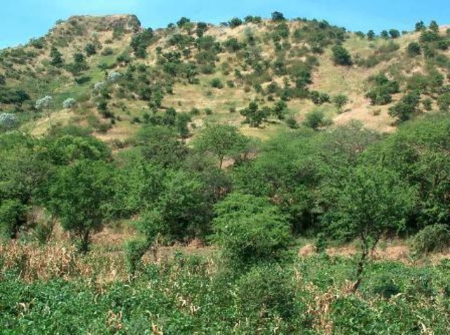
2.3 技术照片
2.5 已应用该技术的、本评估所涵盖的国家/地区/地点
国家:
佛得角
区域/州/省:
Ribeira Seca
有关地点的进一步说明:
S.Lourenço; Picos; St Cruz; S. Domingos
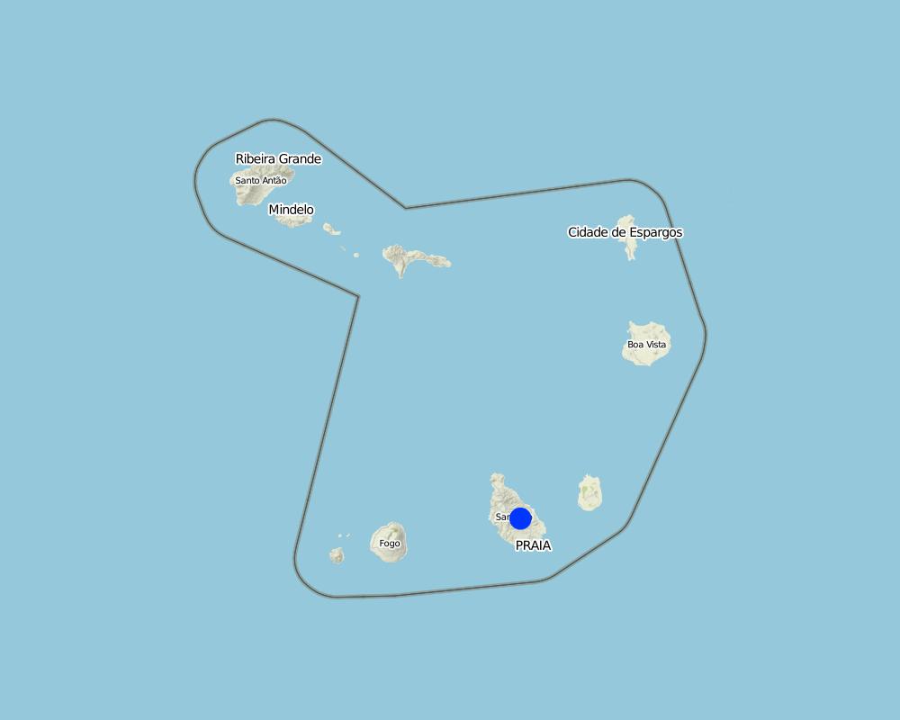
Map
×2.6 实施日期
如果不知道确切的年份,请说明大概的日期:
- 10-50年前
2.7 技术介绍
详细说明该技术是如何引入的:
- 通过项目/外部干预
3. SLM技术的分类
3.1 该技术的主要目的
- 减少、预防、恢复土地退化
3.2 应用该技术的当前土地利用类型

农田
- 一年一作

混合(作物/放牧/树木),包括农林
- 农林牧业
注释:
Major land use problems (compiler’s opinion): Loss of soil by water runoff, reducing its thickness and fertility.
3.3 有关土地利用的更多信息
该技术所应用土地的供水:
- 雨养
注释:
Water supply: Also mixed rainfed - irrigated
具体说明:
Longest growing period in days: 90, Longest growing period from month to month: Aug - Oct
3.4 该技术所属的SLM组
- 地表水管理(泉、河、湖、海)
3.5 技术传播
注释:
Total area covered by the SLM Technology is 71.5 km2.
3.6 包含该技术的可持续土地管理措施

结构措施
- S5:大坝、集水斗、水池
3.7 该技术强调的主要土地退化类型

土壤水蚀
- Wt:表土流失/地表侵蚀
- Wg:冲沟侵蚀/沟蚀

水质恶化
- Hs:地表水良变化
注释:
Main causes of degradation: soil management (Intensive use of land.), crop management (annual, perennial, tree/shrub) (Cultivation of maize in areas unsuitable.), over-exploitation of vegetation for domestic use (Cutting of trees for firewood production.), Heavy / extreme rainfall (intensity/amounts) (High-intensity rainfall), education, access to knowledge and support services
Secondary causes of degradation: deforestation / removal of natural vegetation (incl. forest fires), overgrazing, population pressure, poverty / wealth
3.8 防止、减少或恢复土地退化
具体数量名该技术与土地退化有关的目标:
- 防止土地退化
- 减少土地退化
4. 技术规范、实施活动、投入和成本
4.1 该技术的技术图纸
作者:
Jacques Tavares
4.2 技术规范/技术图纸说明
The unloading of the dam was scaled to a particular section of the basin Maximum Full Flow (Q) = 30 m3 / s. The height of the dike is 5 meters and the length of the discharge is 20 m and height of 90 cm.
Location: Santiago. Cape Verde
Technical knowledge required for field staff / advisors: high
Main technical functions: control of dispersed runoff: retain / trap, reduction of slope angle, increase of infiltration, increase / maintain water stored in soil, increase of groundwater level / recharge of groundwater, sediment retention / trapping, sediment harvesting
Secondary technical functions: reduction of slope length, water harvesting / increase water supply
Dam/ pan/ pond
Vertical interval between structures (m): 29
Spacing between structures (m): 70.9
Construction material (stone): Of dry stone dykes, the sparrow-hawk or mortar
Construction material (concrete): Usually used in the foundation
Construction material (other): Argamassa: Used in stone masonry of the foundation and elevation. Trace 1:4 or 1:5
Slope (which determines the spacing indicated above): 30%
4.3 有关投入和成本计算的一般信息
其它/国家货币(具体说明):
ECV
注明美元与当地货币的汇率(如相关):1美元=:
80.0
注明雇用劳工的每日平均工资成本:
6.25
4.4 技术建立活动
| 活动 | 措施类型 | 时间 | |
|---|---|---|---|
| 1. | Excavation | 结构性的 | Dry period |
| 2. | Masonry Foundation | 结构性的 | Dry period |
| 3. | Masonry Lifting | 结构性的 | Dry period |
4.5 技术建立所需要的费用和投入
注释:
Duration of establishment phase: 2.8 month(s)
4.8 影响成本的最重要因素
描述影响成本的最决定性因素:
Labor (cost) access due to transport of materials, mainly cement, sand and stone
5. 自然和人文环境
5.1 气候
年降雨量
- < 250毫米
- 251-500毫米
- 501-750毫米
- 751-1,000毫米
- 1,001-1,500毫米
- 1,501-2,000毫米
- 2,001-3,000毫米
- 3,001-4,000毫米
- > 4,000毫米
农业气候带
- 半湿润
- 半干旱
5.2 地形
平均坡度:
- 水平(0-2%)
- 缓降(3-5%)
- 平缓(6-10%)
- 滚坡(11-15%)
- 崎岖(16-30%)
- 陡峭(31-60%)
- 非常陡峭(>60%)
地形:
- 高原/平原
- 山脊
- 山坡
- 山地斜坡
- 麓坡
- 谷底
垂直分布带:
- 0-100 m a.s.l.
- 101-500 m a.s.l.
- 501-1,000 m a.s.l.
- 1,001-1,500 m a.s.l.
- 1,501-2,000 m a.s.l.
- 2,001-2,500 m a.s.l.
- 2,501-3,000 m a.s.l.
- 3,001-4,000 m a.s.l.
- > 4,000 m a.s.l.
5.3 土壤
平均土层深度:
- 非常浅(0-20厘米)
- 浅(21-50厘米)
- 中等深度(51-80厘米)
- 深(81-120厘米)
- 非常深(> 120厘米)
土壤质地(表土):
- 粗粒/轻(砂质)
- 中粒(壤土、粉土)
表土有机质:
- 中(1-3%)
- 低(<1%)
如有可能,附上完整的土壤描述或具体说明可用的信息,例如土壤类型、土壤酸碱度、阳离子交换能力、氮、盐度等。:
Soil fertility: Medium
Soil drainage/infiltration: Medium (ranked 1) and good (ranked 2)
Soil water storage capacity: Low (ranked 1) and medium (ranked 2, little deep soils with high slopes)
5.4 水资源可用性和质量
地下水位表:
5-50米
地表水的可用性:
中等
水质(未处理):
不良饮用水(需要处理)
关于水质和水量的注释和进一步规范:
Ground water table: Also > 50 m
Availability of surface water: Medium (Sources in the period of rains, but also through galleries)
Water quality (untreated): Also good drinking water (ranked 2)
5.5 生物多样性
物种多样性:
- 低
5.6 应用该技术的土地使用者的特征
生产系统的市场定位:
- 生计(自给)
- 混合(生计/商业
相对财富水平:
- 贫瘠
- 平均水平
机械化水平:
- 手工作业
- 机械化/电动
说明土地使用者的其他有关特征:
Population density: 100-200 persons/km2
Annual population growth: > 4%; 5% (0.5).
3% of the land users are average wealthy.
80% of the land users are poor.
Market orientation: Subsistence (Many owners have not put their products on the market)
Market orientation: Manual work (ranked 1) and mechanized (ranked 2, some owners rent tractor to plow their land)
5.7 应用该技术的土地使用者拥有或租用的平均土地面积
- < 0.5 公顷
- 0.5-1 公顷
- 1-2 公顷
- 2-5公顷
- 5-15公顷
- 15-50公顷
- 50-100公顷
- 100-500公顷
- 500-1,000公顷
- 1,000-10,000公顷
- > 10,000公顷
5.8 土地所有权、土地使用权和水使用权
土地所有权:
- 个人,有命名
土地使用权:
- 租赁
- 个人
用水权:
- 社区(有组织)
- 个人
5.9 进入服务和基础设施的通道
健康:
- 贫瘠
- 适度的
- 好
教育:
- 贫瘠
- 适度的
- 好
技术援助:
- 贫瘠
- 适度的
- 好
就业(例如非农):
- 贫瘠
- 适度的
- 好
市场:
- 贫瘠
- 适度的
- 好
能源:
- 贫瘠
- 适度的
- 好
道路和交通:
- 贫瘠
- 适度的
- 好
饮用水和卫生设施:
- 贫瘠
- 适度的
- 好
金融服务:
- 贫瘠
- 适度的
- 好
6. 影响和结论性说明
6.1 该技术的现场影响
社会经济效应
生产
作物生产
饲料生产
生产故障风险
生产区域
水资源可用性和质量
饮用水的可用性
饮用水的质量
家畜用水的可用性
家畜用水的质量
灌溉用水的可用性
灌溉用水的质量
社会文化影响
食品安全/自给自足
SLM/土地退化知识
冲突缓解
社会经济弱势群体的情况
Improved livelihoods and human well-being
注释/具体说明:
The construction of a dam can provide increased income for owners benefit, and thus improving their welfare.
生态影响
水循环/径流
水量
水质
水的回收/收集
地表径流
地下水位/含水层
土壤
土壤流失
6.2 该技术的场外影响已经显现
水资源可用性
旱季稳定可靠的水流
下游洪水
下游淤积
地下水/河流污染
对邻近农田的破坏
6.3 技术对渐变气候以及与气候相关的极端情况/灾害的暴露和敏感性(土地使用者认为的极端情况/灾害)
渐变气候
渐变气候
| 季节 | 气候变化/极端天气的类型 | 该技术是如何应对的? | |
|---|---|---|---|
| 年温度 | 增加 | 好 |
气候有关的极端情况(灾害)
气象灾害
| 该技术是如何应对的? | |
|---|---|
| 局地暴雨 | 好 |
| 局地风暴 | 好 |
6.7 该技术的优点/长处/机会
| 土地使用者眼中的长处/优势/机会 |
|---|
| Increase in irrigable area for growing crops. |
| Increased availability of water for irrigation, for livestock and for consumption. |
| 编制者或其他关键资源人员认为的长处/优势/机会 |
|---|
| Reducing the slope of the bed of the streams and hence the speed of water runoff. |
| Facilitates the infiltration of rain water and hence the recharge of aquifers. |
| Correction of watercourses and protection of the margins of streams. |
| Contributes to increasing and maintaining soil humidity. |
7. 参考和链接
7.1 信息的方法/来源
- 实地考察、实地调查
- 与土地使用者的访谈
7.2 参考可用出版物
标题、作者、年份、ISBN:
Field Trip Guid - DESIRE - INIDA - Cabo Verde, 2008
可以从哪里获得?成本如何?
Library of INIDA
标题、作者、年份、ISBN:
Técnicas de Conservação de Solos e Água em Cabo Verde, MPAR & CILSS, 1994.
可以从哪里获得?成本如何?
Library of CFA -INIDA
标题、作者、年份、ISBN:
Conservação de Solo e Água (teoria e prática), Sabino, António Advino, 1991
可以从哪里获得?成本如何?
Library of CFA -INIDA
标题、作者、年份、ISBN:
Conservação de Solo e Água em Cabo Verde, Sabino, António Advino, 1984
可以从哪里获得?成本如何?
Library of INIDA
链接和模块
全部展开 全部收起链接
Formation, Information et Sensibilisation [佛得角]
Éclairer les bénéficiares pour les intégrer convenablement dans la mise en ouvre des activités de conservation des ressources naturelles.
- 编制者: Jacques Tavares
模块
无模块