Water Spreading (typical example from Hashatribab) [苏丹]
- 创建:
- 更新:
- 编制者: Abdalla Osman Eisa
- 编辑者: –
- 审查者: Deborah Niggli, Alexandra Gavilano
Sidud (Local Arabic) - Tarrit (Beja dialect) for earth dams
technologies_1292 - 苏丹
查看章节
全部展开 全部收起1. 一般信息
1.2 参与该技术评估和文件编制的资源人员和机构的联系方式
SLM专业人员:
有助于对技术进行记录/评估的机构名称(如相关)
Soil Conservation, Land Use and Water Adminstratio (Soil Conservation, Land Use and Water Adminstratio) - 苏丹1.3 关于使用通过WOCAT记录的数据的条件
编制者和关键资源人员接受有关使用通过WOCAT记录数据的条件。:
是
1.4 所述技术的可持续性声明
这里所描述的技术在土地退化方面是否存在问题,导致无法被认为是一种可持续的土地管理技术?:
否
1.5 参考关于SLM方法(使用WOCAT记录的SLM方法)的调查问卷
Water Spreading (typical example from Hashatribab) [苏丹]
Construction of water spreading system on khor and wadi with machinery jointly government and farmers in dam compaction and pitching.
- 编制者: Abdalla Osman Eisa
2. SLM技术的说明
2.1 技术简介
技术定义:
Water Spreading (or Spate Irrigation system) conducted through the construction of earth dam structures at the khor cross section.
2.2 技术的详细说明
说明:
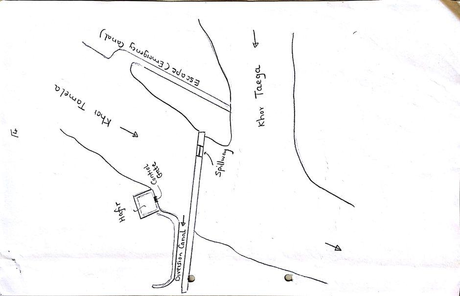
Water Spreading (or Spate Irrigation) can be done through the construction of an angled bank or weir – with a spillway in case of excess flow – to divert a “khor” (ephemeral stream) and spread it (using spaced contour bunds) for crop production.
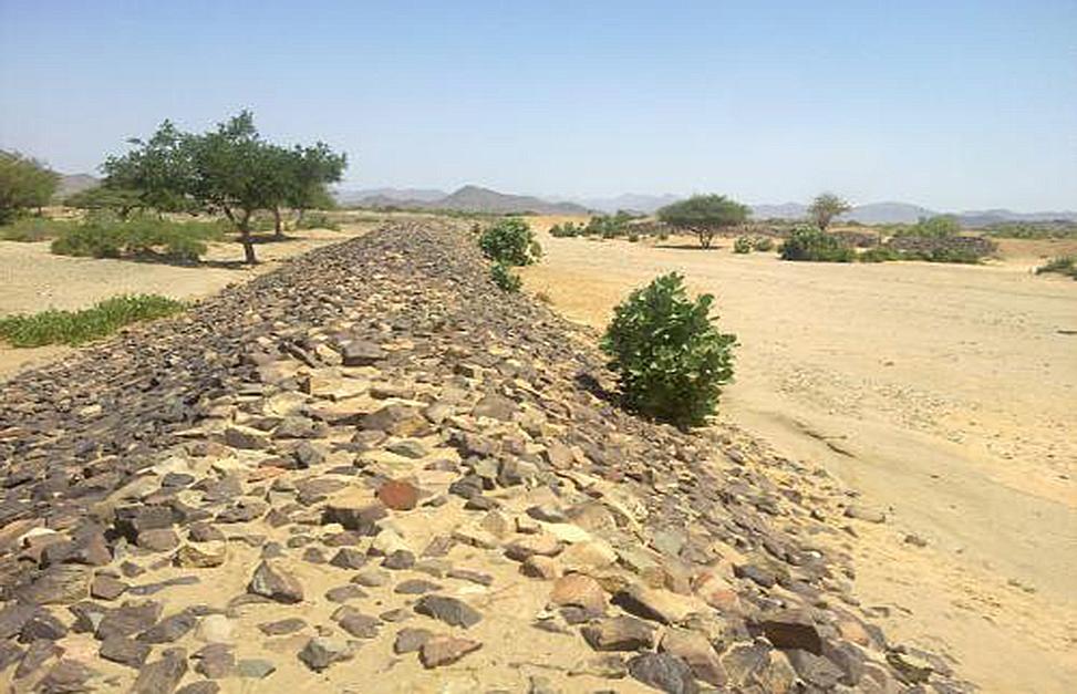
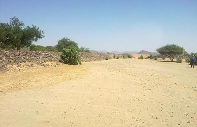
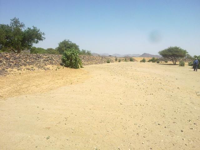
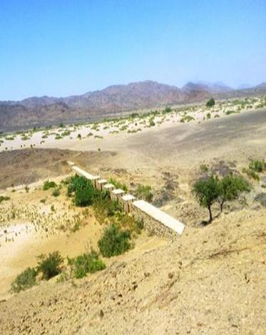
Water Spreading from khors or wadis where channelized runoff/ floodwater is diverted onto plains which are then cultivated on residual moisture. An example of a scheme which was constructed in 1999 is located at Hashitribab, some 7 km from Sinkat on the road towards Kassala. This scheme, comprising a stone-pitched earth diversion barrier across a khor (an ephemeral water course), is documented by using among others the WOCAT Questionnaire and WOCAT’s QA. While the diversion is still intact and provides water to the fields about one kilometre downstream (there were young sorghum plants growing at the time of the visit in November 2011) maintenance will be needed.
There was only a very small input of voluntary labour in its original construction (comprising a contribution in terms of stone pitching).
Construction by the Government, using machinery, with little local contribution might explain why voluntary maintenance of the structures has been negligible. Water spreading schemes have gradually expanded in number over the last 20 years in Red Sea State (according to Sayed Dabloub’s personal comment). Currently it was confirmed that there are new sites under planning and construction.
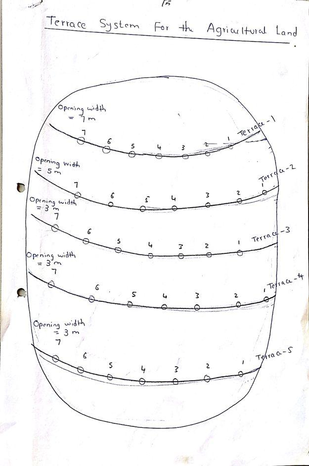
The purposes of diversion dam construction was to divert the main water course to take its way in the crop growing area replacing the old one and being controlled by small diversion dams (terraces to spread water for even water distribution through the original land. These terraces remarkably reduce gully formation.
Most important purpose is to provide water to growing crops in an area which is too dry for rain fed production and where no source for irrigation is available. It secures moisture during the growing season, by allowing more water to penetrate soil and to preserve moisture for a longer period at plant root zone.
The decrease of flood water velocity leads to silt accumulation and other debris materials which increase soil capability in providing moisture, nutrients and maintain soil structure and conservation.
For the earthen/stone-pitched diversion structure with spillway and small haffir alongside machines have been used (mainly loaders provided by the government) which excavated and built the bund. In addition local communities were involved in some aspects of the establishment (mainly stone pitching) supported/subsidized with incentives. The structure/scheme at Hashitribab (close to Sinkat) was built in 1999 (and no maintenance has been done since that time). It helps in watering about 500 feddan (c. 200 hectares) of agricultural area where water is spread by the use of small contour bunds: these were also constructed using subsidies and machines.
Terraces are usually used to control water spreading along the cropped area. Those terraces usually receive the water at low speed velocity. For that reason they are very small in size and volume. Usually they are located in very gentle and uniformed areas. The terraces can be constructed by simple hand tool and tractors accessories. But the prolonged drought makes the maintenance difficult as the dry soil is more susceptible to wind erosion and sand accumulation on both sides of the dam and the bottom of the bund is one of several desertification phenomenon in the region. But the wind-blown sand is one of the most serious one especially in the dry lands of the Red Sea State. Contour survey for land leveling slope identification and location is an important step before implementation.
The study site is located in the arid region of Red Sea State where steep hills from north-south inland mountains are interrupted by arid plains. The population density is low and the population depends on both cropping and livestock with high incidence of poverty. For this reason there should be a clear plan for construction and community extension approach to care about the maintenance of the technology. About 120 families live in Hashitribab area. All the year round they secure their provision by storing food crops in particular sorghum.
2.3 技术照片
媒体库
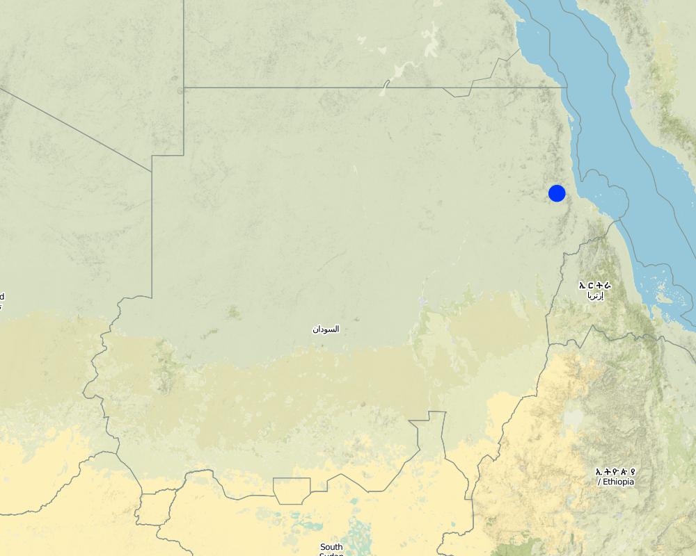
2.5 已应用该技术的、本评估所涵盖的国家/地区/地点
国家:
苏丹
区域/州/省:
Red Sea
有关地点的进一步说明:
Sinkat Locality
具体说明该技术的分布:
- 均匀地分布在一个区域
如果不知道精确的区域,请注明大致覆盖的区域:
- 1-10 平方千米
Map
×2.6 实施日期
如果不知道确切的年份,请说明大概的日期:
- 10-50年前
2.7 技术介绍
详细说明该技术是如何引入的:
- 通过土地使用者的创新
注释(项目类型等):
This scheme was built – in 1999 - on the site of a smaller traditional diversion
3. SLM技术的分类
3.1 该技术的主要目的
- 改良生产
- 减少、预防、恢复土地退化
3.2 应用该技术的当前土地利用类型

农田
- 一年一作
年作 - 具体指明作物:
- 谷类 - 高粱
每年的生长季节数:
- 1
具体说明:
Longest growing period in days: 90
注释:
Major land use problems (compiler’s opinion): Soil vulnerability to erosion due to rainfall irregularity and characterized by drought cycles; in some years rainfall recorded complete absence. Bare and and dried soils are easily affected by erosion agents (wind and water erosion) as these soils are weakly tolerant. Soils in plains are very poor, not renewable and are affected more than soils in seasonable rivers which are renewable with high soil water moisture.
Major land use problems (land users’ perception): Rain fed soils are weak in moisture holding capacity contrast to soils in flush irrigation soils and preferably used for seasonal cultivation by users and producing stable food crops with good productivity besides all underground water for human consumption and livestock through wells at reasonable depths are to be found.
Future (final) land use (after implementation of SLM Technology): Cropland: Ca: Annual cropping
3.3 由于技术的实施,土地使用是否发生了变化?
农田
- 一年一作
3.4 供水
其它(比如洪水后):
- post-flooding
3.5 该技术所属的SLM组
- 横坡措施
- 引水和排水
3.6 包含该技术的可持续土地管理措施

结构措施
- S2:堤、岸
3.7 该技术强调的主要土地退化类型

土壤水蚀
- Wt:表土流失/地表侵蚀
- Wg:冲沟侵蚀/沟蚀
- Wo:场外劣化效应
注释:
Main causes of degradation: crop management (annual, perennial, tree/shrub) (Clearance of land from resdues to mitigate erosion), overgrazing (Stocking at trees and shrubs continue during the flowering stage preventing seeds production.), industrial activities and mining (To manage mining activities.), change in temperature (Reduced rainfall rate and more affection by wind erosion.), change of seasonal rainfall (More unpredictable and uncertain), Heavy / extreme rainfall (intensity/amounts) (affect in water erosin), droughts (affect passively on the vegetation cover and disintegration of rural families.), poverty / wealth (Not able to conserve resources)
Secondary causes of degradation: soil management (Breaking and blanking soil clods, and leveling and furrowing to increase soil roughness specially at wet seasons to reduce water erodability.), deforestation / removal of natural vegetation (incl. forest fires) (excessive use of tree products), over-exploitation of vegetation for domestic use (Rising population and thus more resource requirements. This is typically is round growing population at urban at centres unlike to people in rural areas except at rainy season where they are gathered), urbanisation and infrastructure development (Sequence to absence of infrastructures and related problems of drought increased rural migration to urban areas.), wind storms / dust storms (Erosion of top soil by wind blown.), floods (unless controlled), inputs and infrastructure: (roads, markets, distribution of water points, other, …) (Blocking water flow in some areas), education, access to knowledge and support services (Low environmental awareness and preparedness.)
3.8 防止、减少或恢复土地退化
具体数量名该技术与土地退化有关的目标:
- 防止土地退化
- 修复/恢复严重退化的土地
4. 技术规范、实施活动、投入和成本
4.1 该技术的技术图纸
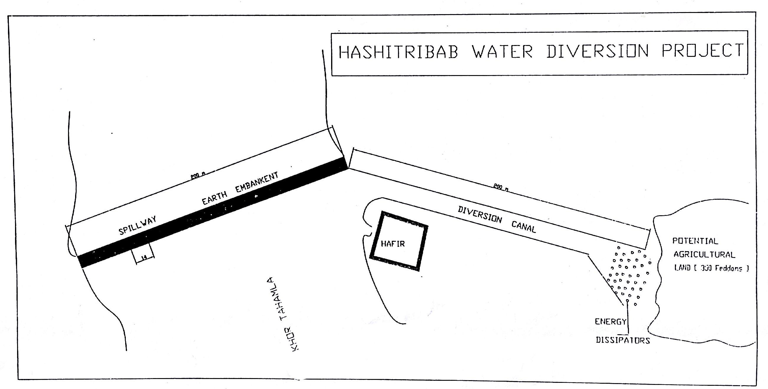
作者:
Dr. Adil Khidir, Fuculty of Engineering, Kartoum University
4.3 技术建立活动
| 活动 | 时间(季度) | |
|---|---|---|
| 1. | Excavation of foundation trenches. | 1 week |
| 2. | Backfilling with heavy soil | 1 day |
| 3. | Establishment diversion structure | 8 weeks |
| 4. | Stonepitching by hand | 3 weeks |
| 5. | Construction of spillway | 2 weeks |
4.4 技术建立所需要的费用和投入
| 对投入进行具体说明 | 单位 | 数量 | 单位成本 | 每项投入的总成本 | 土地使用者承担的成本% | |
|---|---|---|---|---|---|---|
| 劳动力 | labour | ha | 1.0 | 57.0 | 57.0 | |
| 设备 | machine use | ha | 1.0 | 355.0 | 355.0 | |
| 技术建立所需总成本 | 412.0 | |||||
| 技术建立总成本,美元 | 412.0 | |||||
4.5 维护/经常性活动
| 活动 | 时间/频率 | |
|---|---|---|
| 1. | Tillage | before fluding period |
4.6 维护/经常性活动所需要的费用和投入(每年)
注释:
For the diversion structure and spillway at time of construction (1999)
4.7 影响成本的最重要因素
描述影响成本的最决定性因素:
The slope and depth of the wadi/ khor to be diverted
5. 自然和人文环境
5.1 气候
年降雨量
- < 250毫米
- 251-500毫米
- 501-750毫米
- 751-1,000毫米
- 1,001-1,500毫米
- 1,501-2,000毫米
- 2,001-3,000毫米
- 3,001-4,000毫米
- > 4,000毫米
农业气候带
- 干旱
Thermal climate class: tropics
5.2 地形
平均坡度:
- 水平(0-2%)
- 缓降(3-5%)
- 平缓(6-10%)
- 滚坡(11-15%)
- 崎岖(16-30%)
- 陡峭(31-60%)
- 非常陡峭(>60%)
地形:
- 高原/平原
- 山脊
- 山坡
- 山地斜坡
- 麓坡
- 谷底
垂直分布带:
- 0-100 m a.s.l.
- 101-500 m a.s.l.
- 501-1,000 m a.s.l.
- 1,001-1,500 m a.s.l.
- 1,501-2,000 m a.s.l.
- 2,001-2,500 m a.s.l.
- 2,501-3,000 m a.s.l.
- 3,001-4,000 m a.s.l.
- > 4,000 m a.s.l.
5.3 土壤
平均土层深度:
- 非常浅(0-20厘米)
- 浅(21-50厘米)
- 中等深度(51-80厘米)
- 深(81-120厘米)
- 非常深(> 120厘米)
表土有机质:
- 低(<1%)
5.4 水资源可用性和质量
地下水位表:
< 5米
水质(未处理):
不良饮用水(需要处理)
5.6 应用该技术的土地使用者的特征
生产系统的市场定位:
- 生计(自给)
非农收入:
- 收入的10-50%
个人或集体:
- 个人/家庭
机械化水平:
- 手工作业
性别:
- 女人
- 男人
说明土地使用者的其他有关特征:
Land users applying the Technology are mainly disadvantaged land users
Population density: < 10 persons/km2
Annual population growth: 2% - 3%
100% of the land users are poor.
Off-farm income specification: Other activities include casual labour and livestock raising
5.7 应用该技术的土地使用者使用的平均土地面积
- < 0.5 公顷
- 0.5-1 公顷
- 1-2 公顷
- 2-5公顷
- 5-15公顷
- 15-50公顷
- 50-100公顷
- 100-500公顷
- 500-1,000公顷
- 1,000-10,000公顷
- > 10,000公顷
这被认为是小规模、中规模还是大规模的(参照当地实际情况)?:
- 小规模的
5.8 土地所有权、土地使用权和水使用权
土地所有权:
- 社区/村庄
- 个人,有命名
土地使用权:
- 社区(有组织)
- 个人
5.9 进入服务和基础设施的通道
健康:
- 贫瘠
- 适度的
- 好
教育:
- 贫瘠
- 适度的
- 好
技术援助:
- 贫瘠
- 适度的
- 好
就业(例如非农):
- 贫瘠
- 适度的
- 好
市场:
- 贫瘠
- 适度的
- 好
能源:
- 贫瘠
- 适度的
- 好
道路和交通:
- 贫瘠
- 适度的
- 好
饮用水和卫生设施:
- 贫瘠
- 适度的
- 好
6. 影响和结论性说明
6.1 该技术的现场影响
社会经济效应
生产
作物生产
注释/具体说明:
Relative to nothing otherwise
饲料生产
生产故障风险
生产区域
水资源可用性和质量
饮用水的可用性
收入和成本
农业收入
收入来源的多样性
社会文化影响
食品安全/自给自足
文化机会
娱乐机会
社区机构
competition with natural ecosystem
注释/具体说明:
Floodwaters diverted will not reach original destination and those former beneficiaries
contribution to human well-being
注释/具体说明:
Due to more reliable production despite low and variable rainfall
生态影响
水循环/径流
水量
水质
水的回收/收集
地表径流
蒸发
土壤
土壤水分
土壤覆盖层
土壤有机物/地下C
其它生态影响
competition with natural ecosystem
注释/具体说明:
Floodwaters diverted will not reach original destination
6.2 该技术的场外影响已经显现
水资源可用性
下游洪水
6.3 技术对渐变气候以及与气候相关的极端情况/灾害的暴露和敏感性(土地使用者认为的极端情况/灾害)
渐变气候
渐变气候
| 季节 | 增加或减少 | 该技术是如何应对的? | |
|---|---|---|---|
| 年温度 | 增加 | 好 |
气候有关的极端情况(灾害)
水文灾害
| 该技术是如何应对的? | |
|---|---|
| 比较和缓的(河道)洪水 | 好 |
注释:
Construction of water spreading devices serves to preserve water, reduce the waste, increase soil moisture capacity and raise soil fertility (silt accumulation)
6.4 成本效益分析
技术收益与技术建立成本相比如何(从土地使用者的角度看)?
短期回报:
稍微积极
长期回报:
积极
注释:
no maintenance carried out so not applicable here
6.5 技术采用
- > 50%
注释:
75% of land user families have adopted the Technology with external material support
102 land user families have adopted the Technology with external material support, scheme construction subsidised by Government
15% of land user families have adopted the Technology without any external material support
18 land user families have adopted the Technology without any external material support
There is no trend towards spontaneous adoption of the Technology. People cannot construct khor/ wadi diversion barriers themselves by hand
6.7 该技术的优点/长处/机会
| 编制者或其他关键资源人员认为的长处/优势/机会 |
|---|
| Useful and important in the area where floodwater harvesting/ spate irrigation is the only option for crop production. No rain fed irrigation system on the Red Sea State unlike to other Sudan. |
6.8 技术的弱点/缺点/风险及其克服方法
| 土地使用者认为的弱点/缺点/风险 | 如何克服它们? |
|---|---|
| SLM not falls under the community responsibility. They believe SLM is completely Gos role. | Land users awareness and involvement |
| They don’t think that community plays a role in the ongoing soil and vegetation degradation | Rotational grazing and seed broadcasting |
| They also say no regular concern by the government is given in relation to land reclamation | A location of budget and equipment to reclaim land and natural vegetation conservation. |
| They confirm that the physical conditions played a great role in land degradation e.g. drought aridity and high temperatures . | To ensure water harvesting and without waste. |
| 编制者或其他关键资源人员认为的弱点/缺点/风险 | 如何克服它们? |
|---|---|
| High cost (needs machinery to move earth) | More support from Government and outside |
| Not enough trained personnel | More up-grading skills are required |
| Very little data available (apart from construction details) | Better system of monitoring and evaluation |
| Low technical capacity of the community | Capacity building and training |
7. 参考和链接
7.1 信息的方法/来源
- 实地考察、实地调查
- 与土地使用者的访谈
链接和模块
全部展开 全部收起链接
Water Spreading (typical example from Hashatribab) [苏丹]
Construction of water spreading system on khor and wadi with machinery jointly government and farmers in dam compaction and pitching.
- 编制者: Abdalla Osman Eisa
模块
无模块