Water Spreading (typical example from Hashatribab) [Судан]
- Шинийг нээх:
- Шинэчлэх:
- Эмхэтгэгч: Abdalla Osman Eisa
- Хянан тохиолдуулагч: –
- Хянагчид: Deborah Niggli, Alexandra Gavilano
Sidud (Local Arabic) - Tarrit (Beja dialect) for earth dams
technologies_1292 - Судан
Бүлгүүдийг үзэх
Бүгдийг дэлгэх Бүгдийг хаах1. Ерөнхий мэдээлэл
1.2 Технологийг үнэлэх, баримтжуулах ажилд хамаарах мэдээлэл өгсөн хүмүүс, байгууллагуудын холбоо барих мэдээлэл
ГТМ мэргэжилтэн:
Технологи баримтжуулах/үнэлэх ажилд дэмжлэг үзүүлсэн байгууллага(ууд)-ын нэр (шаардлагатай бол)
Soil Conservation, Land Use and Water Adminstratio (Soil Conservation, Land Use and Water Adminstratio) - Судан1.3 ВОКАТ-аар баримтжуулсан өгөгдлийг ашиглахтай холбоотой нөхцөл
Эмхэтгэгч болон гол мэдээлэгч хүн(хүмүүс) WOCAT аргачлалаар баримтжуулсан мэдээллийг ашиглахтай холбоотой нөхцлийг хүлээн зөвшөөрсөн:
Тийм
1.4 Технологи тогтвортой гэдгийг баталгаажуулах
Энэ технологийг газрын доройтлыг бууруулж, газрын тогтвортой менежментийг хангахад тохиромжтой гэж үзэж болох уу?
Үгүй
1.5 ГТМ Арга барилын Асуулга (ууд) руу хандах (ВОКАТ ашиглан баримтжуулсан)
Water Spreading (typical example from Hashatribab) [Судан]
Construction of water spreading system on khor and wadi with machinery jointly government and farmers in dam compaction and pitching.
- Эмхэтгэгч: Abdalla Osman Eisa
2. ГТМ Технологийн тодорхойлолт
2.1 Технологийн товч тодорхойлолт
Технологийн тодорхойлолт:
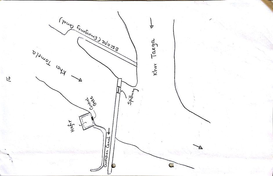
Water Spreading (or Spate Irrigation system) conducted through the construction of earth dam structures at the khor cross section.
2.2 Технологийн дэлгэрэнгүй тодорхойлолт
Тодорхойлолт:
Water Spreading (or Spate Irrigation) can be done through the construction of an angled bank or weir – with a spillway in case of excess flow – to divert a “khor” (ephemeral stream) and spread it (using spaced contour bunds) for crop production.
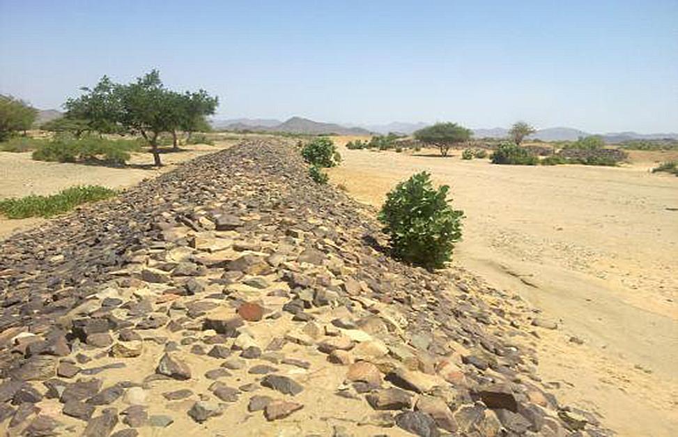
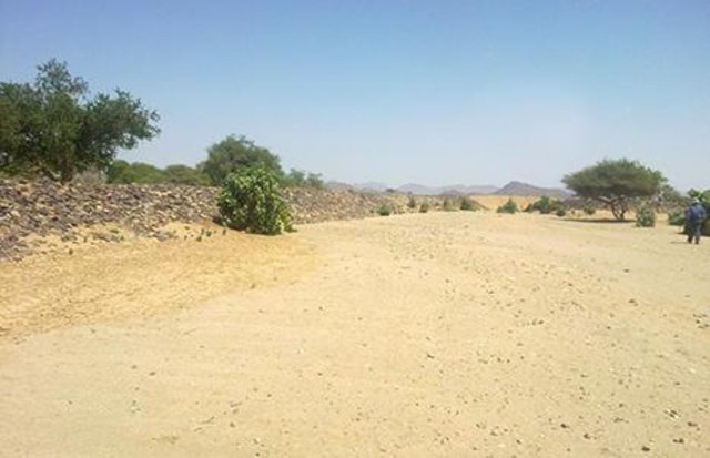
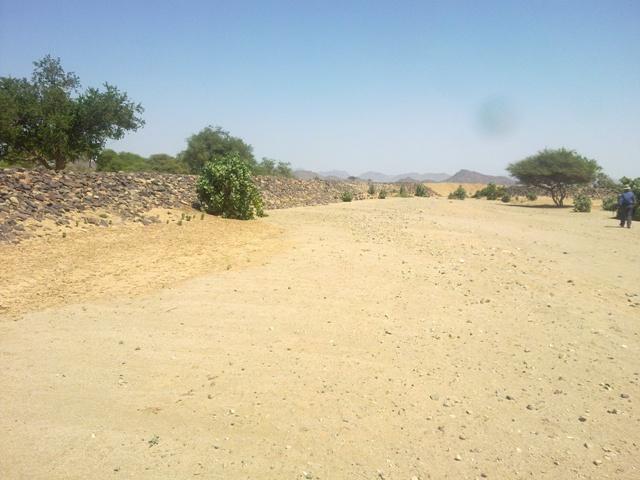
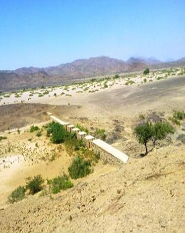
Water Spreading from khors or wadis where channelized runoff/ floodwater is diverted onto plains which are then cultivated on residual moisture. An example of a scheme which was constructed in 1999 is located at Hashitribab, some 7 km from Sinkat on the road towards Kassala. This scheme, comprising a stone-pitched earth diversion barrier across a khor (an ephemeral water course), is documented by using among others the WOCAT Questionnaire and WOCAT’s QA. While the diversion is still intact and provides water to the fields about one kilometre downstream (there were young sorghum plants growing at the time of the visit in November 2011) maintenance will be needed.
There was only a very small input of voluntary labour in its original construction (comprising a contribution in terms of stone pitching).
Construction by the Government, using machinery, with little local contribution might explain why voluntary maintenance of the structures has been negligible. Water spreading schemes have gradually expanded in number over the last 20 years in Red Sea State (according to Sayed Dabloub’s personal comment). Currently it was confirmed that there are new sites under planning and construction.
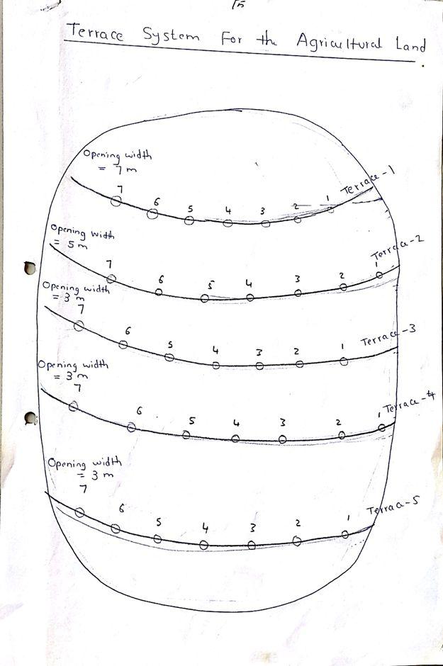
The purposes of diversion dam construction was to divert the main water course to take its way in the crop growing area replacing the old one and being controlled by small diversion dams (terraces to spread water for even water distribution through the original land. These terraces remarkably reduce gully formation.
Most important purpose is to provide water to growing crops in an area which is too dry for rain fed production and where no source for irrigation is available. It secures moisture during the growing season, by allowing more water to penetrate soil and to preserve moisture for a longer period at plant root zone.
The decrease of flood water velocity leads to silt accumulation and other debris materials which increase soil capability in providing moisture, nutrients and maintain soil structure and conservation.
For the earthen/stone-pitched diversion structure with spillway and small haffir alongside machines have been used (mainly loaders provided by the government) which excavated and built the bund. In addition local communities were involved in some aspects of the establishment (mainly stone pitching) supported/subsidized with incentives. The structure/scheme at Hashitribab (close to Sinkat) was built in 1999 (and no maintenance has been done since that time). It helps in watering about 500 feddan (c. 200 hectares) of agricultural area where water is spread by the use of small contour bunds: these were also constructed using subsidies and machines.
Terraces are usually used to control water spreading along the cropped area. Those terraces usually receive the water at low speed velocity. For that reason they are very small in size and volume. Usually they are located in very gentle and uniformed areas. The terraces can be constructed by simple hand tool and tractors accessories. But the prolonged drought makes the maintenance difficult as the dry soil is more susceptible to wind erosion and sand accumulation on both sides of the dam and the bottom of the bund is one of several desertification phenomenon in the region. But the wind-blown sand is one of the most serious one especially in the dry lands of the Red Sea State. Contour survey for land leveling slope identification and location is an important step before implementation.
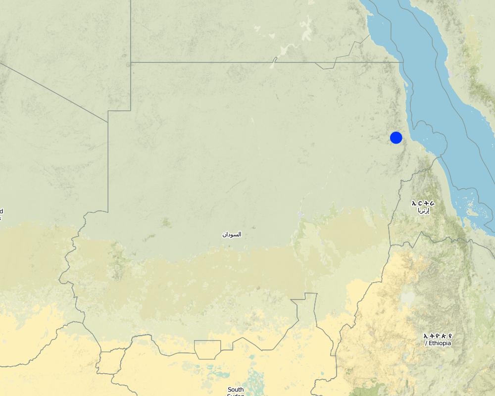
The study site is located in the arid region of Red Sea State where steep hills from north-south inland mountains are interrupted by arid plains. The population density is low and the population depends on both cropping and livestock with high incidence of poverty. For this reason there should be a clear plan for construction and community extension approach to care about the maintenance of the technology. About 120 families live in Hashitribab area. All the year round they secure their provision by storing food crops in particular sorghum.
2.3 Технологийн гэрэл зураг
Медиа галерей
2.5 Энэ үнэлгээнд хамрагдсан технологийг хэрэгжүүлсэн улс орон/ бүс нутаг/ байршил
Улс:
Судан
Улс/аймаг/сум:
Red Sea
Байршлын дэлгэрэнгүй тодорхойлолт:
Sinkat Locality
Технологи өргөн дэлгэрсэн эсхийг тодорхойл:
- газар дээр жигд тархсан
Хэрэв талбайн хэмжээ тодорхойгүй бол талбайн хэмжээг ойролцоогоор тодорхойлно уу:
- 1-10 км2
Map
×2.6 Хэрэгжсэн хугацаа
Байгуулсан тодорхой оныг мэдэхгүй бол баримжаа хугацааг тодорхойл:
- 10-50 жилийн өмнө
2.7 Технологийн танилцуулга
Технологийг хэрхэн нэвтрүүлснийг тодорхойл:
- Газар ашиглагчдын санаачилгаар
Тайлбар (төслийн төрөл г.м.):
This scheme was built – in 1999 - on the site of a smaller traditional diversion
3. ГТМ технологийн ангилал
3.1 Технологийн үндсэн зорилго (ууд)
- үйлдвэрлэлийг сайжруулах
- газрын доройтлыг бууруулах, сэргийлэх, нөхөн сэргээх
3.2 Технологи нэвтрүүлсэн газрын одоогийн газар ашиглалтын хэлбэр(үүд)

Тариалангийн талбай
- Нэг наст үр тариа
Нэг наст үр тариа - Таримлыг тодорхойлно уу:
- үр тариа - жирийн сорго
Жилд ургамал ургах улирлын тоо:
- 1
Тодорхойлно уу:
Longest growing period in days: 90
Тайлбар:
Major land use problems (compiler’s opinion): Soil vulnerability to erosion due to rainfall irregularity and characterized by drought cycles; in some years rainfall recorded complete absence. Bare and and dried soils are easily affected by erosion agents (wind and water erosion) as these soils are weakly tolerant. Soils in plains are very poor, not renewable and are affected more than soils in seasonable rivers which are renewable with high soil water moisture.
Major land use problems (land users’ perception): Rain fed soils are weak in moisture holding capacity contrast to soils in flush irrigation soils and preferably used for seasonal cultivation by users and producing stable food crops with good productivity besides all underground water for human consumption and livestock through wells at reasonable depths are to be found.
Future (final) land use (after implementation of SLM Technology): Cropland: Ca: Annual cropping
3.3 Технологи хэрэгжүүлснээр газар ашиглалтад өөрчлөлт гарсан уу?
Тариалангийн талбай
- Нэг наст үр тариа
3.4 Усан хангамж
бусад (жишээ нь, үерийн дараах):
- post-flooding
3.5 Технологи ГТМ-ийн аль бүлэгт хамаарах вэ
- Налуугийн арга хэмжээ
- Усны урсац зохицуулах болон салаалах
3.6 Технологийг бүрдүүлэх ГТМ арга хэмжээ

Барилга байгууламжийн арга хэмжээ
- S2: Далан, хаалт
3.7 Технологид харгалзах газрын доройтлын төрөл

хөрс усаар эвдрэх
- Wt: Хөрсний гадаргын угаагдал
- Wg: Гуу жалгын элэгдэл
- Wo: Усны элэгдлийн дам нөлөө
Тайлбар:
Main causes of degradation: crop management (annual, perennial, tree/shrub) (Clearance of land from resdues to mitigate erosion), overgrazing (Stocking at trees and shrubs continue during the flowering stage preventing seeds production.), industrial activities and mining (To manage mining activities.), change in temperature (Reduced rainfall rate and more affection by wind erosion.), change of seasonal rainfall (More unpredictable and uncertain), Heavy / extreme rainfall (intensity/amounts) (affect in water erosin), droughts (affect passively on the vegetation cover and disintegration of rural families.), poverty / wealth (Not able to conserve resources)
Secondary causes of degradation: soil management (Breaking and blanking soil clods, and leveling and furrowing to increase soil roughness specially at wet seasons to reduce water erodability.), deforestation / removal of natural vegetation (incl. forest fires) (excessive use of tree products), over-exploitation of vegetation for domestic use (Rising population and thus more resource requirements. This is typically is round growing population at urban at centres unlike to people in rural areas except at rainy season where they are gathered), urbanisation and infrastructure development (Sequence to absence of infrastructures and related problems of drought increased rural migration to urban areas.), wind storms / dust storms (Erosion of top soil by wind blown.), floods (unless controlled), inputs and infrastructure: (roads, markets, distribution of water points, other, …) (Blocking water flow in some areas), education, access to knowledge and support services (Low environmental awareness and preparedness.)
3.8 Газрын доройтлоос урьдчилан сэргийлэх, сааруулах ба нөхөн сэргээх
Газрын доройтолтой холбоотойгоор Технологи ямар зорилго тавьсан болохыг тодорхойл:
- газрын доройтлоос урьдчилан сэргийлэх
- Хүчтэй доройтсон газрыг нөхөн сэргээх/ сайжруулах
4. Техникийн нөхцөл, хэрэгжүүлсэн үйл ажиллагаа, материал ба зардал
4.1 Технологийн техник зураг
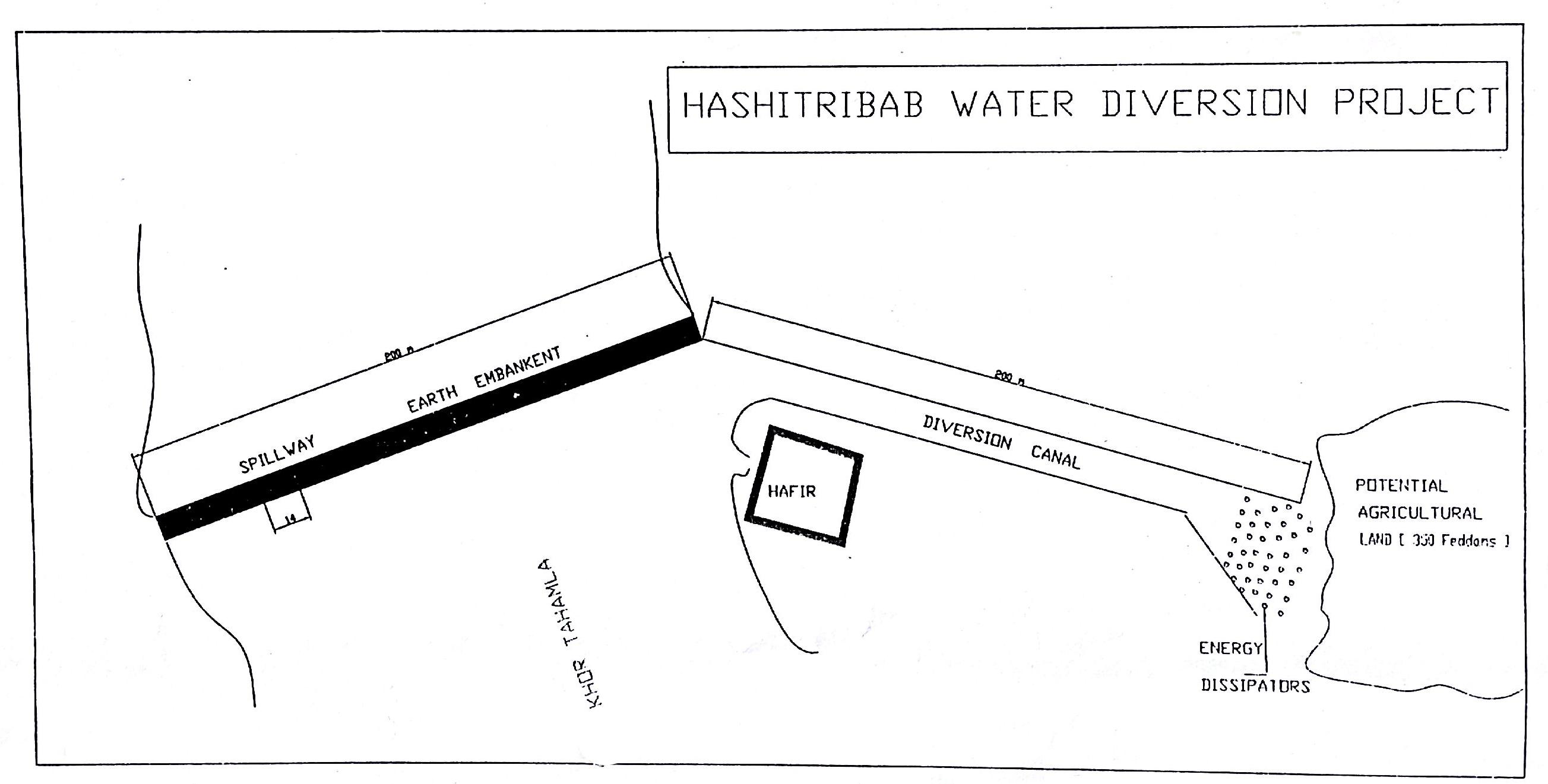
Зохиогч:
Dr. Adil Khidir, Fuculty of Engineering, Kartoum University
4.3 Бий болгох үйл ажиллагаа
| Үйл ажиллагаа | Хугацаа (улирал) | |
|---|---|---|
| 1. | Excavation of foundation trenches. | 1 week |
| 2. | Backfilling with heavy soil | 1 day |
| 3. | Establishment diversion structure | 8 weeks |
| 4. | Stonepitching by hand | 3 weeks |
| 5. | Construction of spillway | 2 weeks |
4.4 Бий болгоход шаардагдсан зардал, хөрөнгийн өртөг
| Зардлын нэр, төрөл | Хэмжих нэгж | Тоо хэмжээ | Нэгжийн үнэ | Зардал бүрийн нийт өртөг | Нийт дүнгээс газар ашиглагчийн төлсөн % | |
|---|---|---|---|---|---|---|
| Хөдөлмөр эрхлэлт | labour | ha | 1.0 | 57.0 | 57.0 | |
| Тоног төхөөрөмж | machine use | ha | 1.0 | 355.0 | 355.0 | |
| Технологи бий болгох нийт үнэ өртөг | 412.0 | |||||
| Технологи бий болгох нийт үнэ өртөг, ам.доллар | 412.0 | |||||
4.5 Арчилгаа/ урсгал үйл ажиллагаа
| Үйл ажиллагаа | Хугацаа/ давтамж | |
|---|---|---|
| 1. | Tillage | before fluding period |
4.6 Арчилгаа/урсгал ажилд шаардагдсан зардал, хөрөнгийн өртөг (нэг жилд)
Тайлбар:
For the diversion structure and spillway at time of construction (1999)
4.7 Зардалд нөлөөлж байгаа хамгийн чухал хүчин зүйл
Өртөг, зардалд нөлөөлөх гол хүчин зүйл:
The slope and depth of the wadi/ khor to be diverted
5. Байгаль ба нийгмийн нөхцөл
5.1 Уур амьсгал
Жилийн нийлбэр хур тундас
- < 250 мм
- 251-500 мм
- 501-750 мм
- 751-1,000 мм
- 1,001-1,500 мм
- 1,501-2,000 мм
- 2,001-3,000 мм
- 3,001-4,000 мм
- > 4,000 мм
Агро-уур амьсгалын бүс
- хуурай
Thermal climate class: tropics
5.2 Гадаргын хэлбэр
Дундаж налуу:
- хавтгай (0-2 %)
- бага зэрэг налуу (3-5 %)
- дунд зэрэг налуу (6-10 % )
- хэвгий (11-15 %)
- налуу (16-30 %)
- их налуу (31-60 % )
- эгц налуу (>60 %)
Гадаргын хэлбэр:
- тэгш өндөрлөг / тал
- нуруу
- уулын энгэр
- дов толгод
- бэл
- хөндий
Өндрийн бүслүүр:
- 0-100 д.т.д. м.
- 101-500 д.т.д. м.
- 501-1,000 д.т.д м.
- 1,001-1,500 д.т.д м.
- 1,501-2,000 д.т.д м.
- 2,001-2,500 д.т.д. м.
- 2,501-3,000 д.т.д. м.
- 3,001-4,000 д.т.д м.
- > 4,000 д.т.д. м.
5.3 Хөрс
Хөрсний дундаж зузаан:
- маш нимгэн (0-20 см)
- нимгэн (21-50 см)
- дунд зэрэг зузаан (51-80 см)
- зузаан (81-120 cм)
- маш зузаан (>120 cм)
Өнгөн хөрсөнд агуулагдах ялзмаг:
- бага (<1 % )
5.4 Усны хүртээмж ба чанар
Гүний усны түвшин:
< 5 м
Усны чанар (цэвэршүүлээгүй):
муу чанарын ундны ус (цэвэршүүлэх шаардлагатай)
5.6 Технологи нэвтрүүлсэн газар ашиглагчдын тухай мэдээлэл
Үйлдвэрлэлийн системийн зах зээлийн чиг баримжаа:
- амь зуух арга хэлбэрийн (өөрийгөө хангах)
Бусад эх үүсвэрээс олох орлого:
- Нийт орлогын 10-50 %
Хувь хүн эсвэл бүлэг:
- Хувь хүн / өрх
Механикжилтын түвшин:
- гар ажил
Хүйс:
- эмэгтэй
- эрэгтэй
Газар ашиглагчдын бусад шинж чанарыг тодорхойл:
Land users applying the Technology are mainly disadvantaged land users
Population density: < 10 persons/km2
Annual population growth: 2% - 3%
100% of the land users are poor.
Off-farm income specification: Other activities include casual labour and livestock raising
5.7 Газар ашиглагчийн технологи нэвтрүүлсэн газрын дундаж талбайн хэмжээ
- < 0.5 га
- 0.5-1 га
- 1-2 га
- 2-5 га
- 5-15 га
- 15-50 га
- 50-100 га
- 100-500 га
- 500-1,000 га
- 1,000-10,000 га
- > 10,000 га
Энэ талбай том, жижиг, дунд алинд хамаарах вэ (орон нутгийн нөхцөлд харгалзуулна уу)?
- бага-хэмжээний
5.8 Газар эзэмшил, газар ашиглах эрх, ус ашиглах эрх
Газар өмчлөл:
- нэгдлийн/ тосгон
- хувь хүн, өмчийн гэрчилгээтэй
Газар ашиглах эрх:
- нэгдлийн хэлбэрээр (зохион байгуулалттай)
- хувь хүн
5.9 Дэд бүтэц, үйлчилгээний хүртээмж
эрүүл мэнд:
- ядуу
- дунд зэргийн
- сайн
боловсрол:
- ядуу
- дунд зэргийн
- сайн
техник зөвлөгөө:
- ядуу
- дунд зэргийн
- сайн
хөдөлмөр эрхлэлт (жишээ нь, ХАА-аас өөр):
- ядуу
- дунд зэргийн
- сайн
зах зээл:
- ядуу
- дунд зэргийн
- сайн
эрчим хүчний хангамж:
- ядуу
- дунд зэргийн
- сайн
зам тээвэр:
- ядуу
- дунд зэргийн
- сайн
усан хангамж ба ариутгал:
- ядуу
- дунд зэргийн
- сайн
6. Үр нөлөө ба дүгнэлт
6.1 Технологийн талбайд үзүүлсэн нөлөө
Нийгэм-эдийн засгийн үр нөлөө
Үйлдвэрлэл
газар тариалангийн үйлдвэрлэл
Тайлбар/ тодорхой дурьдах:
Relative to nothing otherwise
тэжээл үйлдвэрлэл
бүтээмж буурах эрсдэл
үйлдвэрлэлийн газар
Усны хүртээмж ба чанар
ундны усны хүрэлцээ
Орлого, зарлага
тухайн аж ахуйн орлого
орлогын олон янз эх үүсвэр
Нийгэм-соёлын үр нөлөө
хүнсний аюулгүй байдал/ өөрийн хэрэгцээг хангах
соёлын боломжууд
амралт, рекреацийн боломжууд
олон нийтийн институц
competition with natural ecosystem
Тайлбар/ тодорхой дурьдах:
Floodwaters diverted will not reach original destination and those former beneficiaries
contribution to human well-being
Тайлбар/ тодорхой дурьдах:
Due to more reliable production despite low and variable rainfall
Экологийн үр нөлөө
Усны эргэлт/ илүүдэл
усны хэмжээ
усны чанар
ус хураах / цуглуулах
гадаргын урсац
ууршилт
Хөрс
хөрсний чийг
хөрсөн бүрхэвч
хөрсний органик нэгдэл/ хөрсөнд агуулагдах карбон
Экологийн бусад үр нөлөө
competition with natural ecosystem
Тайлбар/ тодорхой дурьдах:
Floodwaters diverted will not reach original destination
6.2 Технологийн талбайн гадна үзүүлсэн үр нөлөө
Усны хүртээмж
голын адагт үерлэх
6.3 Технологийн уур амьсгалын өөрчлөлт, цаг агаарын гамшигт үзэгдэлд өртөх байдал ба эмзэг байдал (газар ашиглагчийн бодлоор)
Уур амьсгалын аажим өөрчлөлт
Уур амьсгалын аажим өөрчлөлт
| Улирал | Өсөх эсвэл буурах | Технологи түүний нөлөөг хэрхэн бууруулж байна? | |
|---|---|---|---|
| жилийн дундаж температур | Өсөлт | сайн |
Уур амьсгалаас хамаарах аюул (гамшиг)
Усзүйн гамшиг
| Технологи түүний нөлөөг хэрхэн бууруулж байна? | |
|---|---|
| усны үер (гол) | сайн |
Тайлбар:
Construction of water spreading devices serves to preserve water, reduce the waste, increase soil moisture capacity and raise soil fertility (silt accumulation)
6.4 Өртөг ба ашгийн шинжилгээ
Бий болгох зардалтай харьцуулахад ямар ашиг өгсөн бэ (газар ашиглагчийн бодлоор)?
Богино хугацаанд эргэн төлөгдөх байдал:
бага зэрэг эерэг
Урт хугацаанд эргэн төлөгдөх байдал:
эерэг
Тайлбар:
no maintenance carried out so not applicable here
6.5 Технологи нэвтрүүлэлт
- > 50%
Тайлбар:
75% of land user families have adopted the Technology with external material support
102 land user families have adopted the Technology with external material support, scheme construction subsidised by Government
15% of land user families have adopted the Technology without any external material support
18 land user families have adopted the Technology without any external material support
There is no trend towards spontaneous adoption of the Technology. People cannot construct khor/ wadi diversion barriers themselves by hand
6.7 Технологийн давуу тал/боломжууд
| Эмхэтгэгч, бусад мэдээлэл өгсөн хүмүүсийн өнцгөөс тодорхойлсон давуу тал/боломжууд |
|---|
| Useful and important in the area where floodwater harvesting/ spate irrigation is the only option for crop production. No rain fed irrigation system on the Red Sea State unlike to other Sudan. |
6.8 Технологийн дутагдалтай/сул тал/аюул болон тэдгээрийг хэрхэн даван туулах арга зам
| Газар ашиглагч нарын тодорхойлсон сул тал/ дутагдал/ эрсдэл | Тэдгээрийг хэрхэн даван туулах вэ? |
|---|---|
| SLM not falls under the community responsibility. They believe SLM is completely Gos role. | Land users awareness and involvement |
| They don’t think that community plays a role in the ongoing soil and vegetation degradation | Rotational grazing and seed broadcasting |
| They also say no regular concern by the government is given in relation to land reclamation | A location of budget and equipment to reclaim land and natural vegetation conservation. |
| They confirm that the physical conditions played a great role in land degradation e.g. drought aridity and high temperatures . | To ensure water harvesting and without waste. |
| Эмхэтгэгч, бусад мэдээлэл өгсөн хүмүүсийн өнцгөөс тодорхойлсон сул тал/ дутагдал/ эрсдэл | Тэдгээрийг хэрхэн даван туулах вэ? |
|---|---|
| High cost (needs machinery to move earth) | More support from Government and outside |
| Not enough trained personnel | More up-grading skills are required |
| Very little data available (apart from construction details) | Better system of monitoring and evaluation |
| Low technical capacity of the community | Capacity building and training |
7. Ном зүй ба холбоосууд
7.1 Мэдээлэл цуглуулсан арга/эх үүсвэр
- Хээрийн уулзалт, судалгаа
- Газар ашиглагчтай хийсэн ярилцлага
Холбоос ба модулууд
Бүгдийг дэлгэх Бүгдийг хаахХолбоосууд
Water Spreading (typical example from Hashatribab) [Судан]
Construction of water spreading system on khor and wadi with machinery jointly government and farmers in dam compaction and pitching.
- Эмхэтгэгч: Abdalla Osman Eisa
Модулууд
Модуль байхгүй байна