Contour "V" Ditch [印度]
- 创建:
- 更新:
- 编制者: Biranchi Mohapatra
- 编辑者: –
- 审查者: Fabian Ottiger
Samapatana V nala
technologies_1478 - 印度
查看章节
全部展开 全部收起1. 一般信息
1.2 参与该技术评估和文件编制的资源人员和机构的联系方式
SLM专业人员:
1.3 关于使用通过WOCAT记录的数据的条件
(现场)数据是什么时候汇编的?:
15/10/2006
编制者和关键资源人员接受有关使用通过WOCAT记录数据的条件。:
是
2. SLM技术的说明
2.1 技术简介
技术定义:
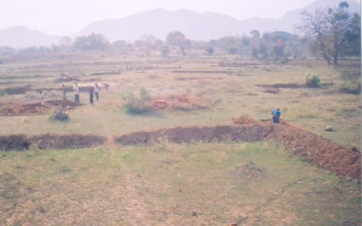
V-ahaped sturcture on contour line in order to check sheet/reel erosion and for moisture retension.
2.2 技术的详细说明
说明:
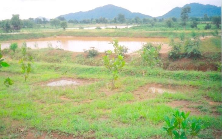
V-shaped structures on contour line .The size of the V ditch varies according to slope, depth of soil and soil texture. The V-ditch can be laid eithr in staggered or continuous. Purpose- 1. To control sheet and reel erosion 2. Retention of in situ soil moisture 3. To increase vegetative cover. Establishment/maintenance -- 1. Bunding, 2. Terracing, 3. Turfing, 4. Provisioin of outlets in contour lines. Environment:- Bio-Physical-1-Cropland-Annual 2. Grazing land-Extensive, 3. Forest, Socio-Economic- 1. land ownership-User Group (32 Members) 2. Land use rights-Usufructary Rights.
2.3 技术照片
媒体库
2.5 已应用该技术的、本评估所涵盖的国家/地区/地点
国家:
印度
区域/州/省:
Orissa
有关地点的进一步说明:
Orissa/Nuapada
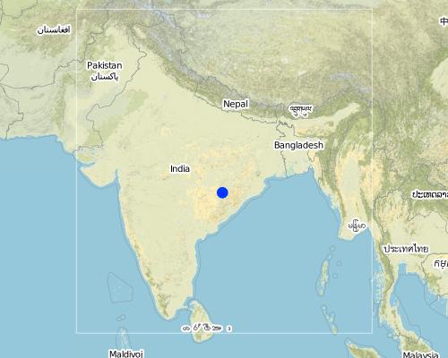
Map
×2.6 实施日期
如果不知道确切的年份,请说明大概的日期:
- 不到10年前(最近)
2.7 技术介绍
详细说明该技术是如何引入的:
- 通过项目/外部干预
注释(项目类型等):
Integarted Watershed Development Project (World bank aided) in Khandhamal and Ganjam districts of Orissa
3. SLM技术的分类
3.1 该技术的主要目的
- 减少、预防、恢复土地退化
3.2 应用该技术的当前土地利用类型

农田
- 一年一作
- 多年一作(非木材)
- 乔木与灌木的种植
主要农作物(经济作物及粮食作物):
Major food crop perennial cropping: Arhar
Major cash crop tree and shrub cropping: Cashew nut
注释:
Major land use problems (compiler’s opinion): (i) Sheet & rill erosion (ii) Low Moisture status.
Major land use problems (land users’ perception): (i) Erosion (ii) Vegetation survival (iii) Low productivity of land
Type of cropping system and major crops comments: No
3.3 有关土地利用的更多信息
该技术所应用土地的供水:
- 雨养
每年的生长季节数:
- 2
具体说明:
Longest growing period in days: 150Longest growing period from month to month: Jun - OctSecond longest growing period in days: 75Second longest growing period from month to month: Nov - Jan
3.4 该技术所属的SLM组
- 横坡措施
- 集水
3.5 技术传播
注释:
Total area covered by the SLM Technology is 0.14 m2.
3.6 包含该技术的可持续土地管理措施
3.7 该技术强调的主要土地退化类型

土壤水蚀
- Wt:表土流失/地表侵蚀
- Wo:场外劣化效应
注释:
Main type of degradation addressed: Wt: loss of topsoil / surface erosion
Secondary types of degradation addressed: Wo: offsite degradation effects
Main causes of degradation: deforestation / removal of natural vegetation (incl. forest fires), other human induced causes (specify) (agricultural causes), education, access to knowledge and support services (lack of knowledge)
Secondary causes of degradation: over-exploitation of vegetation for domestic use, overgrazing, droughts, land tenure (land subdivision), Land alienation
3.8 防止、减少或恢复土地退化
具体数量名该技术与土地退化有关的目标:
- 减少土地退化
4. 技术规范、实施活动、投入和成本
4.1 该技术的技术图纸
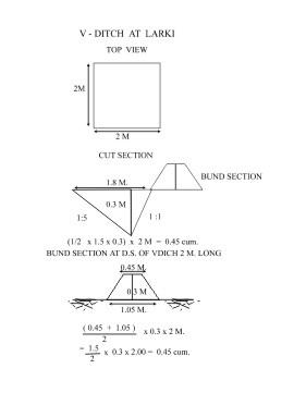
4.2 技术规范/技术图纸说明
V-Ditch technical drawing
Location: QTInd16TechDraw.jpg
Technical knowledge required for field staff / advisors: moderate
Technical knowledge required for land users: low
Main technical functions: control of dispersed runoff: retain / trap
Secondary technical functions: control of dispersed runoff: impede / retard, increase of infiltration, increase / maintain water stored in soil, increase in soil fertility
Vegetative measure: Turfing of bund
Vegetative material: G : grass
Vertical interval between rows / strips / blocks (m): 2
Spacing between rows / strips / blocks (m): 1
Vertical interval within rows / strips / blocks (m): 2
Width within rows / strips / blocks (m): 1.5
Vegetative measure: Vegetative material: G : grass
Vegetative measure: Vegetative material: G : grass
Vegetative measure: Vegetative material: G : grass
Grass species: Vetiver/Berunbuta
Slope (which determines the spacing indicated above): 8.00%
If the original slope has changed as a result of the Technology, the slope today is (see figure below): 6.00%
Gradient along the rows / strips: 0.00%
Structural measure: Contour V ditch
Vertical interval between structures (m): 2
Spacing between structures (m): 1
Depth of ditches/pits/dams (m): average
Width of ditches/pits/dams (m): 2
Length of ditches/pits/dams (m): 1.5
Height of bunds/banks/others (m): 0.3
Width of bunds/banks/others (m): Bottom=0.8 Top=0.2
Length of bunds/banks/others (m): 1.5
Construction material (earth): Soil excavated from the ditches are used to construct banks/bunds
Slope (which determines the spacing indicated above): 8%
If the original slope has changed as a result of the Technology, the slope today is: 6%
Lateral gradient along the structure: 0%
Vegetation is used for stabilisation of structures.
4.3 有关投入和成本计算的一般信息
其它/国家货币(具体说明):
Rupee
注明美元与当地货币的汇率(如相关):1美元=:
50.0
注明雇用劳工的每日平均工资成本:
1.00
4.4 技术建立活动
| 活动 | 措施类型 | 时间 | |
|---|---|---|---|
| 1. | Local grass barrier | 植物性的 | On the onset of monsoon |
| 2. | Cashew plantation | 植物性的 | During rainy season |
| 3. | Survey & layout | 结构性的 | Before onset of monsoon. |
| 4. | Digging of pit & construction of earthen bund | 结构性的 | Premonsoon. |
| 5. | Stone pitching on upstream slope of pit | 结构性的 | Premonsoon. |
| 6. | grass turffing | 结构性的 | monsoon |
4.5 技术建立所需要的费用和投入
| 对投入进行具体说明 | 单位 | 数量 | 单位成本 | 每项投入的总成本 | 土地使用者承担的成本% | |
|---|---|---|---|---|---|---|
| 劳动力 | Labour | ha | 1.0 | 35.0 | 35.0 | |
| 施工材料 | Stone | ha | 1.0 | 5.0 | 5.0 | |
| 技术建立所需总成本 | 40.0 | |||||
注释:
Duration of establishment phase: 12 month(s)
4.6 维护/经常性活动
| 活动 | 措施类型 | 时间/频率 | |
|---|---|---|---|
| 1. | Mini tillage | 农业学的 | khariff / annual |
| 2. | Cover cropping | 农业学的 | khariff / annual |
| 3. | Weeding | 植物性的 | After rooting /Six months |
| 4. | Soil work | 植物性的 | After rooting /Six months |
| 5. | Manuring | 植物性的 | During rainy season /Twice in a year. |
| 6. | Fire Control measures | 植物性的 | During winter season /annual |
| 7. | Turfing of bund with grass | 结构性的 | during rain/annual |
| 8. | De-silting of pits | 结构性的 | before onset of monsoon/annual |
| 9. | Maintaining upstream & down stream arrrangement | 结构性的 | before onset of monsoon/annual |
| 10. | Re-arrangement of displaced stone | 结构性的 | before onset of monsoon/annual |
4.7 维护/经常性活动所需要的费用和投入(每年)
注释:
Length and cross section of the strucutre, stone availability.
4.8 影响成本的最重要因素
描述影响成本的最决定性因素:
Labour availability, Availability of grass/stone , Transportation facility.
5. 自然和人文环境
5.1 气候
年降雨量
- < 250毫米
- 251-500毫米
- 501-750毫米
- 751-1,000毫米
- 1,001-1,500毫米
- 1,501-2,000毫米
- 2,001-3,000毫米
- 3,001-4,000毫米
- > 4,000毫米
指定年平均降雨量(若已知),单位为mm:
1250.00
农业气候带
- 半干旱
5.2 地形
平均坡度:
- 水平(0-2%)
- 缓降(3-5%)
- 平缓(6-10%)
- 滚坡(11-15%)
- 崎岖(16-30%)
- 陡峭(31-60%)
- 非常陡峭(>60%)
地形:
- 高原/平原
- 山脊
- 山坡
- 山地斜坡
- 麓坡
- 谷底
垂直分布带:
- 0-100 m a.s.l.
- 101-500 m a.s.l.
- 501-1,000 m a.s.l.
- 1,001-1,500 m a.s.l.
- 1,501-2,000 m a.s.l.
- 2,001-2,500 m a.s.l.
- 2,501-3,000 m a.s.l.
- 3,001-4,000 m a.s.l.
- > 4,000 m a.s.l.
关于地形的注释和进一步规范:
Landforms: Also mountain slopes and ridges
5.3 土壤
平均土层深度:
- 非常浅(0-20厘米)
- 浅(21-50厘米)
- 中等深度(51-80厘米)
- 深(81-120厘米)
- 非常深(> 120厘米)
土壤质地(表土):
- 粗粒/轻(砂质)
- 中粒(壤土、粉土)
表土有机质:
- 中(1-3%)
如有可能,附上完整的土壤描述或具体说明可用的信息,例如土壤类型、土壤酸碱度、阳离子交换能力、氮、盐度等。:
Soil fertility: Medium
Soil drainage/infiltration: Medium
Soil water storage capacity: Medium (ranked 1) and high (ranked 2)
5.6 应用该技术的土地使用者的特征
生产系统的市场定位:
- 生计(自给)
非农收入:
- > 收入的50%
相对财富水平:
- 非常贫瘠
- 贫瘠
机械化水平:
- 手工作业
说明土地使用者的其他有关特征:
Population density: 100-200 persons/km2
Annual population growth: 1% - 2%
10% of the land users are average wealthy and own 50% of the land.
20% of the land users are poor and own 30% of the land.
70% of the land users are poor and own 20% of the land.
Level of mechanization: Manual work (100% of the activities are performed manuall)
Market orientation: Subsistence (All crops are for self consumption presently)
5.7 应用该技术的土地使用者拥有或租用的平均土地面积
- < 0.5 公顷
- 0.5-1 公顷
- 1-2 公顷
- 2-5公顷
- 5-15公顷
- 15-50公顷
- 50-100公顷
- 100-500公顷
- 500-1,000公顷
- 1,000-10,000公顷
- > 10,000公顷
5.8 土地所有权、土地使用权和水使用权
土地所有权:
- 州
- 个人,有命名
土地使用权:
- 租赁
- 个人
6. 影响和结论性说明
6.1 该技术的现场影响
社会经济效应
生产
作物生产
饲料生产
注释/具体说明:
Nil
饲料质量
注释/具体说明:
Nil
产品多样性
注释/具体说明:
Cover crop, Agro forestry,Fruit crops and Tuber crops taken up
收入和成本
农业收入
注释/具体说明:
Rs. 500/- per Ha. Rs. 10/- per day
工作量
注释/具体说明:
Needs maintenance timely.
社会文化影响
社区机构
注释/具体说明:
Users groups formed and functioning.
SLM/土地退化知识
注释/具体说明:
By the users
冲突缓解
注释/具体说明:
Community mobilisation is requirede to solve conflicts.
生态影响
水循环/径流
地表径流
SLM之前的数量:
65
SLM之后的数量:
40
多余水的排放
注释/具体说明:
Crops grown and supplemental irrigation
土壤
土壤水分
注释/具体说明:
Waste weir disposal
土壤流失
注释/具体说明:
Vegetation established
生物多样性:植被、动物
植物多样性
注释/具体说明:
Due to fertility
6.2 该技术的场外影响已经显现
下游洪水
下游淤积
地下水/河流污染
风力搬运沉积物
6.4 成本效益分析
技术收益与技术建立成本相比如何(从土地使用者的角度看)?
短期回报:
中性/平衡
长期回报:
积极
技术收益与技术维护成本/经常性成本相比如何(从土地使用者的角度看)?
短期回报:
积极
长期回报:
非常积极
6.5 技术采用
如若可行,进行量化(住户数量和/或覆盖面积):
34
在所有采用这项技术的人当中,有多少人是自发地采用该技术,即未获得任何物质奖励/付款?:
- 0-10%
注释:
15% of land user families have adopted the Technology with external material support
32 land user families have adopted the Technology with external material support
Comments on acceptance with external material support: survey results
5% of land user families have adopted the Technology without any external material support
2 land user families have adopted the Technology without any external material support
Comments on spontaneous adoption: survey results
6.7 该技术的优点/长处/机会
| 土地使用者眼中的长处/优势/机会 |
|---|
|
Low cost Simple technology User friendly Affordable How can they be sustained / enhanced? Guidance on cropping practices |
| 编制者或其他关键资源人员认为的长处/优势/机会 |
|---|
|
Based on traditional practices Low Cost Farmers can maintain Coserve insitu soil moisture Conserve the most vluable top soil How can they be sustained / enhanced? Involve people in planning Involve farmers while executing Place suitable disposal system in right places Regular maintenance Establishment of vegetative measures Adoption of proper cropping practices by the farmers |
6.8 技术的弱点/缺点/风险及其克服方法
| 土地使用者认为的弱点/缺点/风险 | 如何克服它们? |
|---|---|
| Apprehend getting benefits which will suffice their livelihoods | Off farm activities tomake them financially sound. |
| 编制者或其他关键资源人员认为的弱点/缺点/风险 | 如何克服它们? |
|---|---|
| Conflicts in future among farmers | Exposure on group dynamics and management of common property |
| Mobilisation of DWF and developemnt of corpus fund | Community organisation to generate corpus fund |
链接和模块
全部展开 全部收起链接
无链接
模块
无模块