Contour "V" Ditch [อินเดีย]
- ผู้สร้างสรรค์:
- การอัพเดท:
- ผู้รวบรวม: Biranchi Mohapatra
- ผู้เรียบเรียง: –
- ผู้ตรวจสอบ: Fabian Ottiger
Samapatana V nala
technologies_1478 - อินเดีย
ดูส่วนย่อย
ขยายทั้งหมด ย่อทั้งหมด1. ข้อมูลทั่วไป
1.2 รายละเอียดที่ติดต่อได้ของผู้รวบรวมและองค์กรที่เกี่ยวข้องในการประเมินและการจัดเตรียมทำเอกสารของเทคโนโลยี
ผู้เชี่ยวชาญ SLM:
1.3 เงื่อนไขการใช้ข้อมูลที่ได้บันทึกผ่านทาง WOCAT
วันที่เก็บรวบรวมข้อมูล(ภาคสนาม) :
15/10/2006
ผู้รวบรวมและวิทยากรหลักยอมรับเงื่อนไขเกี่ยวกับการใช้ข้อมูลที่ถูกบันทึกผ่านทาง WOCAT:
ใช่
2. การอธิบายลักษณะของเทคโนโลยี SLM
2.1 การอธิบายแบบสั้น ๆ ของเทคโนโลยี
คำจำกัดความของเทคโนโลยี:
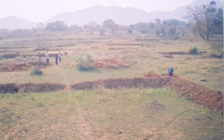
V-ahaped sturcture on contour line in order to check sheet/reel erosion and for moisture retension.
2.2 การอธิบายแบบละเอียดของเทคโนโลยี
คำอธิบาย:
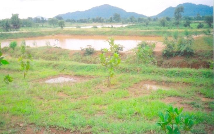
V-shaped structures on contour line .The size of the V ditch varies according to slope, depth of soil and soil texture. The V-ditch can be laid eithr in staggered or continuous. Purpose- 1. To control sheet and reel erosion 2. Retention of in situ soil moisture 3. To increase vegetative cover. Establishment/maintenance -- 1. Bunding, 2. Terracing, 3. Turfing, 4. Provisioin of outlets in contour lines. Environment:- Bio-Physical-1-Cropland-Annual 2. Grazing land-Extensive, 3. Forest, Socio-Economic- 1. land ownership-User Group (32 Members) 2. Land use rights-Usufructary Rights.
2.3 รูปภาพของเทคโนโลยี
อัลบั้มสื่อบันทึก
2.5 ประเทศภูมิภาค หรือสถานที่ตั้งที่เทคโนโลยีได้นำไปใช้และได้รับการครอบคลุมโดยการประเมินนี้
ประเทศ:
อินเดีย
ภูมิภาค/รัฐ/จังหวัด:
Orissa
ข้อมูลจำเพาะเพิ่มเติมของสถานที่ตั้ง :
Orissa/Nuapada
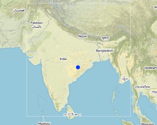
Map
×2.6 วันที่การดำเนินการ
ถ้าไม่รู้ปีที่แน่นอน ให้ระบุวันที่โดยประมาณ:
- น้อยกว่า 10 ปี (ไม่นานนี้)
2.7 คำแนะนำของเทคโนโลยี
ให้ระบุว่าเทคโนโลยีถูกแนะนำเข้ามาอย่างไร:
- ทางโครงการหรือจากภายนอก
ความคิดเห็น (ประเภทของโครงการ เป็นต้น) :
Integarted Watershed Development Project (World bank aided) in Khandhamal and Ganjam districts of Orissa
3. การจัดประเภทของเทคโนโลยี SLM
3.1 วัตถุประสงค์หลักของเทคโนโลยี
- ลด ป้องกัน ฟื้นฟู การเสื่อมโทรมของที่ดิน
3.2 ประเภทของการใช้ที่ดินในปัจจุบันที่ได้นำเทคโนโลยีไปใช้

พื้นที่ปลูกพืช
- การปลูกพืชล้มลุกอายุปีเดียว
- การปลูกพืชยืนต้นที่ไม่มีเนื้อไม้
- การปลูกไม้ยืนต้น ไม้พุ่ม
พืชหลัก (พืชเศรษฐกิจและพืชอาหาร):
Major food crop perennial cropping: Arhar
Major cash crop tree and shrub cropping: Cashew nut
แสดงความคิดเห็น:
Major land use problems (compiler’s opinion): (i) Sheet & rill erosion (ii) Low Moisture status.
Major land use problems (land users’ perception): (i) Erosion (ii) Vegetation survival (iii) Low productivity of land
Type of cropping system and major crops comments: No
3.3 ข้อมูลเพิ่มเติมเกี่ยวกับการใช้ที่ดิน
การใช้น้ำของที่ดินที่มีการใช้เทคโนโลยีอยู่:
- จากน้ำฝน
จำนวนของฤดูเพาะปลูกต่อปี:
- 2
ระบุ:
Longest growing period in days: 150Longest growing period from month to month: Jun - OctSecond longest growing period in days: 75Second longest growing period from month to month: Nov - Jan
3.4 กลุ่ม SLM ที่ตรงกับเทคโนโลยีนี้
- มาตรการปลูกพืชขวางความลาดชัน (cross-slope measure)
- การเก็บเกี่ยวน้ำ
3.5 กระจายตัวของเทคโนโลยี
แสดงความคิดเห็น:
Total area covered by the SLM Technology is 0.14 m2.
3.6 มาตรการ SLM ที่ประกอบกันเป็นเทคโนโลยี
3.7 รูปแบบหลักของการเสื่อมโทรมของที่ดินที่ได้รับการแก้ไขโดยเทคโนโลยี

การกัดกร่อนของดินโดยน้ำ
- Wt (Loss of topsoil): การสูญเสียดินชั้นบนหรือการกัดกร่อนที่ผิวดิน
- Wo (Offsite degradation): ผลกระทบนอกพื้นที่
แสดงความคิดเห็น:
Main type of degradation addressed: Wt: loss of topsoil / surface erosion
Secondary types of degradation addressed: Wo: offsite degradation effects
Main causes of degradation: deforestation / removal of natural vegetation (incl. forest fires), other human induced causes (specify) (agricultural causes), education, access to knowledge and support services (lack of knowledge)
Secondary causes of degradation: over-exploitation of vegetation for domestic use, overgrazing, droughts, land tenure (land subdivision), Land alienation
3.8 การป้องกัน การลดลง หรือการฟื้นฟูความเสื่อมโทรมของที่ดิน
ระบุเป้าหมายของเทคโนโลยีกับความเสื่อมโทรมของที่ดิน:
- ลดความเสื่อมโทรมของดิน
4. ข้อมูลจำเพาะด้านเทคนิค กิจกรรมการนำไปปฏิบัติใช้ ปัจจัยนำเข้า และค่าใช้จ่าย
4.1 แบบแปลนทางเทคนิคของเทคโนโลยี
4.2 ข้อมูลจำเพาะด้านเทคนิคและการอธิบายแบบแปลนทางเทคนิค
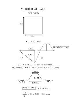
V-Ditch technical drawing
Location: QTInd16TechDraw.jpg
Technical knowledge required for field staff / advisors: moderate
Technical knowledge required for land users: low
Main technical functions: control of dispersed runoff: retain / trap
Secondary technical functions: control of dispersed runoff: impede / retard, increase of infiltration, increase / maintain water stored in soil, increase in soil fertility
Vegetative measure: Turfing of bund
Vegetative material: G : grass
Vertical interval between rows / strips / blocks (m): 2
Spacing between rows / strips / blocks (m): 1
Vertical interval within rows / strips / blocks (m): 2
Width within rows / strips / blocks (m): 1.5
Vegetative measure: Vegetative material: G : grass
Vegetative measure: Vegetative material: G : grass
Vegetative measure: Vegetative material: G : grass
Grass species: Vetiver/Berunbuta
Slope (which determines the spacing indicated above): 8.00%
If the original slope has changed as a result of the Technology, the slope today is (see figure below): 6.00%
Gradient along the rows / strips: 0.00%
Structural measure: Contour V ditch
Vertical interval between structures (m): 2
Spacing between structures (m): 1
Depth of ditches/pits/dams (m): average
Width of ditches/pits/dams (m): 2
Length of ditches/pits/dams (m): 1.5
Height of bunds/banks/others (m): 0.3
Width of bunds/banks/others (m): Bottom=0.8 Top=0.2
Length of bunds/banks/others (m): 1.5
Construction material (earth): Soil excavated from the ditches are used to construct banks/bunds
Slope (which determines the spacing indicated above): 8%
If the original slope has changed as a result of the Technology, the slope today is: 6%
Lateral gradient along the structure: 0%
Vegetation is used for stabilisation of structures.
4.3 ข้อมูลทั่วไปเกี่ยวกับการคำนวณปัจจัยนำเข้าและค่าใช้จ่าย
อื่นๆ หรือสกุลเงินประจำชาติ (ระบุ):
Rupee
ระบุอัตราแลกเปลี่ยนจากดอลลาร์สหรัฐเป็นสกุลเงินท้องถิ่น (ถ้าเกี่ยวข้อง) คือ 1 เหรียญสหรัฐ =:
50.0
ระบุค่าเฉลี่ยของค่าจ้างในการจ้างแรงงานต่อวัน:
1.00
4.4 กิจกรรมเพื่อการจัดตั้ง
| กิจกรรม | ประเภทของมาตรการ | ช่วงเวลาดำเนินการ | |
|---|---|---|---|
| 1. | Local grass barrier | ด้วยวิธีพืช | On the onset of monsoon |
| 2. | Cashew plantation | ด้วยวิธีพืช | During rainy season |
| 3. | Survey & layout | ด้วยโครงสร้าง | Before onset of monsoon. |
| 4. | Digging of pit & construction of earthen bund | ด้วยโครงสร้าง | Premonsoon. |
| 5. | Stone pitching on upstream slope of pit | ด้วยโครงสร้าง | Premonsoon. |
| 6. | grass turffing | ด้วยโครงสร้าง | monsoon |
4.5 ค่าใช้จ่ายของปัจจัยนำเข้าที่จำเป็นสำหรับการจัดตั้ง
| ปัจจัยนำเข้า | หน่วย | ปริมาณ | ค่าใช้จ่ายต่อหน่วย | ค่าใช้จ่ายทั้งหมดต่อปัจจัยนำเข้า | %ของค่าใช้จ่ายที่ก่อให้เกิดขึ้นโดยผู้ใช้ที่ดิน | |
|---|---|---|---|---|---|---|
| แรงงาน | Labour | ha | 1.0 | 35.0 | 35.0 | |
| วัสดุสำหรับก่อสร้าง | Stone | ha | 1.0 | 5.0 | 5.0 | |
| ค่าใช้จ่ายทั้งหมดของการจัดตั้งเทคโนโลยี | 40.0 | |||||
แสดงความคิดเห็น:
Duration of establishment phase: 12 month(s)
4.6 การบำรุงรักษาสภาพหรือกิจกรรมที่เกิดขึ้นเป็นประจำ
| กิจกรรม | ประเภทของมาตรการ | ช่วงระยะเวลา/ความถี่ | |
|---|---|---|---|
| 1. | Mini tillage | จัดการพืช | khariff / annual |
| 2. | Cover cropping | จัดการพืช | khariff / annual |
| 3. | Weeding | ด้วยวิธีพืช | After rooting /Six months |
| 4. | Soil work | ด้วยวิธีพืช | After rooting /Six months |
| 5. | Manuring | ด้วยวิธีพืช | During rainy season /Twice in a year. |
| 6. | Fire Control measures | ด้วยวิธีพืช | During winter season /annual |
| 7. | Turfing of bund with grass | ด้วยโครงสร้าง | during rain/annual |
| 8. | De-silting of pits | ด้วยโครงสร้าง | before onset of monsoon/annual |
| 9. | Maintaining upstream & down stream arrrangement | ด้วยโครงสร้าง | before onset of monsoon/annual |
| 10. | Re-arrangement of displaced stone | ด้วยโครงสร้าง | before onset of monsoon/annual |
4.7 ค่าใช้จ่ายของปัจจัยนำเข้าและกิจกรรมที่เกิดขึ้นเป็นประจำที่ต้องการการบำรุงรักษา (ต่อปี)
แสดงความคิดเห็น:
Length and cross section of the strucutre, stone availability.
4.8 ปัจจัยสำคัญที่สุดที่มีผลกระทบต่อค่าใช้จ่าย
ปัจจัยสำคัญที่สุดที่มีผลกระทบต่อค่าใช้จ่ายต่างๆ:
Labour availability, Availability of grass/stone , Transportation facility.
5. สิ่งแวดล้อมทางธรรมชาติและของมนุษย์
5.1 ภูมิอากาศ
ฝนประจำปี
- < 250 ม.ม.
- 251-500 ม.ม.
- 501-750 ม.ม.
- 751-1,000 ม.ม.
- 1,001-1,500 ม.ม.
- 1,501-2,000 ม.ม.
- 2,001-3,000 ม.ม.
- 3,001-4,000 ม.ม.
- > 4,000 ม.ม.
ระบุปริมาณน้ำฝนเฉลี่ยรายปี (ถ้ารู้) :หน่วย ม.ม.
1250.00
เขตภูมิอากาศเกษตร
- กึ่งแห้งแล้ง
5.2 สภาพภูมิประเทศ
ค่าเฉลี่ยความลาดชัน:
- ราบเรียบ (0-2%)
- ลาดที่ไม่ชัน (3-5%)
- ปานกลาง (6-10%)
- เป็นลูกคลื่น (11-15%)
- เป็นเนิน (16-30%)
- ชัน (31-60%)
- ชันมาก (>60%)
ธรณีสัณฐาน:
- ที่ราบสูง/ที่ราบ
- สันเขา
- ไหล่เขา
- ไหล่เนินเขา
- ตีนเนิน
- หุบเขา
ระดับความสูง:
- 0-100 เมตร
- 101-500 เมตร
- 501-1,000 เมตร
- 1,001-1,500 เมตร
- 1,501-2,000 เมตร
- 2,001-2,500 เมตร
- 2,501-3,000 เมตร
- 3,001-4,000 เมตร
- > 4,000 เมตร
ความคิดเห็นและข้อมูลจำเพาะเพิ่มเติมเรื่องสภาพภูมิประเทศ:
Landforms: Also mountain slopes and ridges
5.3 ดิน
ค่าเฉลี่ยความลึกของดิน:
- ตื้นมาก (0-20 ซ.ม.)
- ตื้น (21-50 ซ.ม.)
- ลึกปานกลาง (51-80 ซ.ม.)
- ลึก (81-120 ซ.ม.)
- ลึกมาก (>120 ซ.ม.)
เนื้อดิน (ดินชั้นบน):
- หยาบ/เบา (ดินทราย)
- ปานกลาง (ดินร่วน ทรายแป้ง)
อินทรียวัตถุในดิน:
- ปานกลาง (1-3%)
(ถ้ามี) ให้แนบคำอธิบายเรื่องดินแบบเต็มหรือระบุข้อมูลที่มีอยู่ เช่น ชนิดของดิน ค่า pH ของดินหรือความเป็นกรดของดิน ความสามารถในการแลกเปลี่ยนประจุบวก ไนโตรเจน ความเค็ม เป็นต้น:
Soil fertility: Medium
Soil drainage/infiltration: Medium
Soil water storage capacity: Medium (ranked 1) and high (ranked 2)
5.6 ลักษณะของผู้ใช้ที่ดินที่นำเทคโนโลยีไปปฏิบัติใช้
แนวทางการตลาดของระบบการผลิต:
- เพื่อการยังชีพ (หาเลี้ยงตนเอง)
รายได้ที่มาจากนอกฟาร์ม:
- > 50% ของรายได้ทั้งหมด
ระดับของความมั่งคั่งโดยเปรียบเทียบ:
- ยากจนมาก
- จน
ระดับของการใช้เครื่องจักรกล:
- งานที่ใช้แรงกาย
ระบุลักษณะอื่นๆที่เกี่ยวข้องของผู้ใช้ที่ดิน:
Population density: 100-200 persons/km2
Annual population growth: 1% - 2%
10% of the land users are average wealthy and own 50% of the land.
20% of the land users are poor and own 30% of the land.
70% of the land users are poor and own 20% of the land.
Level of mechanization: Manual work (100% of the activities are performed manuall)
Market orientation: Subsistence (All crops are for self consumption presently)
5.7 พื้นที่เฉลี่ยของที่ดินที่เป็นเจ้าของหรือเช่าโดยผู้ใช้ที่ดินที่นำเทคโนโลยีไปปฏิบัติใช้
- < 0.5 เฮกตาร์
- 0.5-1 เฮกตาร์
- 1-2 เฮกตาร์
- 2-5 เฮกตาร์
- 5-15 เฮกตาร์
- 15-50 เฮกตาร์
- 50-100 เฮกตาร์
- 100-500 เฮกตาร์
- 500-1,000 เฮกตาร์
- 1,000-10,000 เฮกตาร์
- >10,000 เฮกตาร์
5.8 กรรมสิทธิ์ในที่ดิน สิทธิในการใช้ที่ดินและสิทธิในการใช้น้ำ
กรรมสิทธิ์ในที่ดิน:
- รัฐ
- รายบุคคล ได้รับสิทธิครอบครอง
สิทธิในการใช้ที่ดิน:
- เช่า
- รายบุคคล
6. ผลกระทบและสรุปคำบอกกล่าว
6.1 ผลกระทบในพื้นที่ดำเนินการ (On-site) จากการใช้เทคโนโลยี
ผลกระทบทางด้านเศรษฐกิจและสังคม
การผลิต
การผลิตพืชผล
การผลิตพืชที่ใช้เลี้ยงปศุสัตว์
แสดงความคิดเห็น/ระบุ:
Nil
คุณภาพพืชที่ใช้เลี้ยงปศุสัตว์
แสดงความคิดเห็น/ระบุ:
Nil
ความหลากหลายของผลิตภัณฑ์
แสดงความคิดเห็น/ระบุ:
Cover crop, Agro forestry,Fruit crops and Tuber crops taken up
รายได้และค่าใช้จ่าย
รายได้จากฟาร์ม
แสดงความคิดเห็น/ระบุ:
Rs. 500/- per Ha. Rs. 10/- per day
ภาระงาน
แสดงความคิดเห็น/ระบุ:
Needs maintenance timely.
ผลกระทบด้านสังคมวัฒนธรรมอื่น ๆ
สถาบันของชุมชน
แสดงความคิดเห็น/ระบุ:
Users groups formed and functioning.
SLM หรือความรู้เรื่องความเสื่อมโทรมของที่ดิน
แสดงความคิดเห็น/ระบุ:
By the users
การบรรเทาความขัดแย้ง
แสดงความคิดเห็น/ระบุ:
Community mobilisation is requirede to solve conflicts.
ผลกระทบด้านนิเวศวิทยา
วัฐจักรน้ำหรือน้ำบ่า
น้ำไหลบ่าที่ผิวดิน
จำนวนก่อน SLM:
65
หลังจาก SLM:
40
การระบายน้ำส่วนเกิน
แสดงความคิดเห็น/ระบุ:
Crops grown and supplemental irrigation
ดิน
ความชื้นในดิน
แสดงความคิดเห็น/ระบุ:
Waste weir disposal
การสูญเสียดิน
แสดงความคิดเห็น/ระบุ:
Vegetation established
ความหลากหลายทางชีวภาพของพืชและสัตว์
ความหลากหลายทางชีวภาพของพืช
แสดงความคิดเห็น/ระบุ:
Due to fertility
6.2 ผลกระทบนอกพื้นที่ดำเนินการ (Off-site) จากการใช้เทคโนโลยี
น้ำท่วมพื้นที่ท้ายน้ำ
การทับถมของดินตะกอนพื้นที่ท้ายน้ำ
การเกิดมลพิษในน้ำบาดาลหรือแม่น้ำ
ตะกอนที่ถูกพัดพามาโดยลม
6.4 การวิเคราะห์ค่าใช้จ่ายและผลประโยชน์ที่ได้รับ
ผลประโยชน์ที่ได้รับเปรียบเทียบกับค่าใช้จ่ายในการจัดตั้งเป็นอย่างไร (จากมุมมองของผู้ใช้ที่ดิน)
ผลตอบแทนระยะสั้น:
เป็นกลางหรือสมดุล
ผลตอบแทนระยะยาว:
ด้านบวก
ผลประโยชน์ที่ได้รับเปรียบเทียบกับค่าใช้จ่ายในการบำรุงรักษาหรือต้นทุนที่เกิดขึ้นซ้ำอีก เป็นอย่างไร (จากมุมมองของผู้ใช้ที่ดิน)
ผลตอบแทนระยะสั้น:
ด้านบวก
ผลตอบแทนระยะยาว:
ด้านบวกอย่างมาก
6.5 การปรับตัวของเทคโนโลยี
ถ้ามีข้อมูลให้บอกปริมาณด้วย (จำนวนของครัวเรือนหรือครอบคลุมพื้นที่):
34
จากทั้งหมดที่ได้รับเทคโนโลยีเข้ามามีจำนวนเท่าใดที่ทำแบบทันที โดยไม่ได้รับการจูงใจด้านวัสดุหรือการเงินใด ๆ:
- 0-10%
แสดงความคิดเห็น:
15% of land user families have adopted the Technology with external material support
32 land user families have adopted the Technology with external material support
Comments on acceptance with external material support: survey results
5% of land user families have adopted the Technology without any external material support
2 land user families have adopted the Technology without any external material support
Comments on spontaneous adoption: survey results
6.7 จุดแข็ง / ข้อได้เปรียบ / โอกาสของเทคโนโลยี
| จุดแข็ง / ข้อได้เปรียบ / โอกาสในทัศนคติของผู้ใช้ที่ดิน |
|---|
|
Low cost Simple technology User friendly Affordable How can they be sustained / enhanced? Guidance on cropping practices |
| จุดแข็ง / ข้อได้เปรียบ / โอกาสในทัศนคติของผู้รวบรวมหรือวิทยากรหลัก |
|---|
|
Based on traditional practices Low Cost Farmers can maintain Coserve insitu soil moisture Conserve the most vluable top soil How can they be sustained / enhanced? Involve people in planning Involve farmers while executing Place suitable disposal system in right places Regular maintenance Establishment of vegetative measures Adoption of proper cropping practices by the farmers |
6.8 จุดอ่อน / ข้อเสียเปรียบ / ความเสี่ยงของเทคโนโลยีและวิธีการแก้ไข
| จุดอ่อน / ข้อเสียเปรียบ / ความเสี่ยงในทัศนคติของผู้ใช้ที่ดิน | มีวิธีการแก้ไขได้อย่างไร |
|---|---|
| Apprehend getting benefits which will suffice their livelihoods | Off farm activities tomake them financially sound. |
| จุดอ่อน / ข้อเสียเปรียบ / ความเสี่ยงในทัศนคติของผู้รวบรวมหรือวิทยากรหลัก | มีวิธีการแก้ไขได้อย่างไร |
|---|---|
| Conflicts in future among farmers | Exposure on group dynamics and management of common property |
| Mobilisation of DWF and developemnt of corpus fund | Community organisation to generate corpus fund |
ลิงก์และโมดูล
ขยายทั้งหมด ย่อทั้งหมดลิงก์
ไม่มีลิงก์
โมดูล
ไม่มีโมดูล