Water-spreading weirs [马里]
- 创建:
- 更新:
- 编制者: Dieter Nill
- 编辑者: –
- 审查者: Deborah Niggli, Alexandra Gavilano
Seuils d’épandage (French)
technologies_1622 - 马里
查看章节
全部展开 全部收起1. 一般信息
1.2 参与该技术评估和文件编制的资源人员和机构的联系方式
SLM专业人员:
Abdou Sani Mamadou
Programme d’Appui à l’agriculture Productive (PROMAP), Niamey, Niger
尼日尔
有助于对技术进行记录/评估的项目名称(如相关)
Good Practices in Soil and Water Conservation - A contribution to adaptation and farmers ́ resilience towards climate change in the Sahel (GIZ)有助于对技术进行记录/评估的机构名称(如相关)
Deutsche Gesellschaft für Internationale Zusammenarbeit (GIZ) - 德国1.3 关于使用通过WOCAT记录的数据的条件
编制者和关键资源人员接受有关使用通过WOCAT记录数据的条件。:
是
1.4 所述技术的可持续性声明
这里所描述的技术在土地退化方面是否存在问题,导致无法被认为是一种可持续的土地管理技术?:
否
2. SLM技术的说明
2.1 技术简介
技术定义:
Water-spreading weirs slow the flow of water, spread it over a wider area, increase infiltration and reduce erosion.
2.2 技术的详细说明
说明:
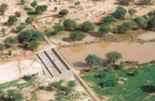
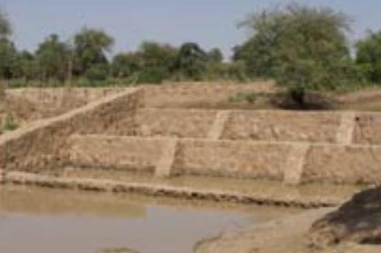
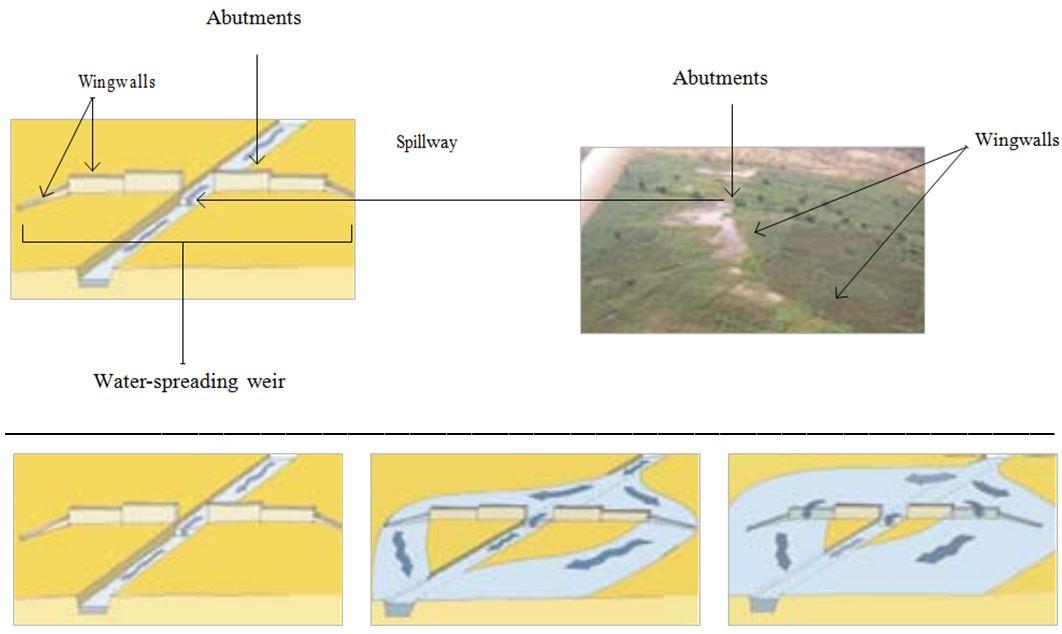
The water-spreading weir technique was developed in Burkina Faso, Niger and Chad in the late 1990s and early 2000s. They are suitable as a land improvement measure for 90% of valleys in the Sahel area. These weirs regulate floodwater in medium-sized watercourses and in wider degraded valley bottoms with a pronounced low-water channel. They are constructed with local materials and have a spillway in the middle, abutments on either side and long wingwalls to spread the water over a large area.
In order to reverse the degradation process in a valley, it is necessary to ensure the comprehensive rehabilitation of the degraded parts of the valley. This is why the technique requires an overall assessment of the valley in order to identify the causes of degradation. In order to restore the water system in a degraded valley, a series of weirs is generally required.
Water-spreading weirs slow the flow of water in valleys and spread it over a wider area where it can infiltrate into the soil. In this way, they control river floodwater, and this reduces erosion and the loss of water. At the same time, sediments improve soil fertility and replenish the water table. When water flow is low in the valley, all the water passes over the spillway. When floodwater flow is stronger, the water is channelled towards the sides and flows over the outer lower wingwalls. When the floodwaters are at their heaviest, the water flows over even the higher walls. Downstream, the waters rejoin the low-water channel. Water-spreading weirs permit the reclamation and rehabilitation of degraded land and the restoration of vegetation cover. Thanks to the weirs, water flowing through the valleys can be used for crop growing, livestock raising and forestry.
Thanks to the infiltration of considerable amounts of water, water-spreading weirs contribute to raising the water table by several metres and improving ecological conditions in adjacent areas. As a result, vegetation cover is restored, which has a positive effect on biodiversity. By 2010, German cooperation had established water-spreading weirs in Niger to improve 10,000 hectares of land in valleys. Sorghum yields increased by between 50% and 100% per ha, from 400 kg to 800 kg per ha. The production of sorghum was 10 to 15 times higher in the improved areas than it had been before. As water-spreading weirs raise the water table, areas can be developed (or abandoned farmland restored) for market gardening and horticulture, with two or three crop harvests a year. The produce is used to supplement the food available and can also be sold (especially market garden produce).
The amount of time spent by women and girls fetching water is reduced by several hours a day. Horticulture generates extra income to cover family expenses, such as education and health care. Growing crops outside the rainy season generates work all year round, which reduces temporary migration.
This technique requires accurate preliminary studies to design the system. The more degraded the valley, the more complex the work is. Improving severely degraded valleys requires extensive experience, and any necessary technical adjustments must be made when flaws are detected.
If the weirs are built to a high standard, with a certain amount of upkeep, they will last. Major repairs are beyond the means of the communities, which is why commune authorities are often assigned the role of project owner. However, this is not yet a satisfactory solution, as in most countries in the Sahel, commune authorities are still weak.
This technique has great potential for climate change adaptation in two scenarios: 1) Water-spreading weirs distribute the watershed’s water over wide areas of land in the valley bottom. This enables water resources to be used more efficiently in low-rainfall periods, during dry spells and when the rainy season ends early. 2) In high-rainfall periods and/or in the event of heavy downpours, water-spreading weirs slow the flow of water, thereby preventing or reducing gully and river bank erosion and protecting areas downstream.
2.3 技术照片
媒体库
2.5 已应用该技术的、本评估所涵盖的国家/地区/地点
国家:
马里
区域/州/省:
Mali, Niger, Burkina Faso, Chad, Ethiopia
注释:
By 2010, German cooperation had established water-spreading weirs in Niger to improve 10,000 hectares of land in valleys
2.6 实施日期
如果不知道确切的年份,请说明大概的日期:
- 10-50年前
2.7 技术介绍
详细说明该技术是如何引入的:
- 通过项目/外部干预
注释(项目类型等):
The water-spreading weir technique was developed in Burkina Faso, Niger and Chad in the late 1990s and early 2000s.
By 2010, German cooperation had established water-spreading weirs in Niger to improve 10,000 hectares of land in valleys.
3. SLM技术的分类
3.1 该技术的主要目的
- 减少、预防、恢复土地退化
3.2 应用该技术的当前土地利用类型

农田
- 一年一作
每年的生长季节数:
- 1
具体说明:
Longest growing period in days: 120, Longest growing period from month to month: August to October

水道、水体、湿地
- 池塘、大坝
注释:
Major land use problems (compiler’s opinion): soil erosion by water and wind erosion, surface runoff, lack of infiltration, fertility decline
Constraints of common grazing land
Constraints of forested government-owned land or commons
3.4 供水
该技术所应用土地的供水:
- 混合雨水灌溉
3.5 该技术所属的SLM组
- 灌溉管理(包括供水、排水)
- 引水和排水
- 地表水管理(泉、河、湖、海)
3.6 包含该技术的可持续土地管理措施

结构措施
- S11:其它
注释:
Specification of other structural measures: water-spreading weirs
3.7 该技术强调的主要土地退化类型

土壤水蚀
- Wt:表土流失/地表侵蚀

土壤风蚀
- Et:表土流失

化学性土壤退化
- Cn:肥力下降和有机质含量下降(非侵蚀所致)

生物性退化
- Bc:植被覆盖的减少

水质恶化
- Ha:干旱化
- Hg:地下水/含水层水位的变化
注释:
Main causes of degradation: crop management (annual, perennial, tree/shrub) (Unadapted landuse methods, reduced or abandoned fallow periods), floods, droughts, population pressure (rapidly growing population increasing pressure on land), land tenure (insecure access to land)
3.8 防止、减少或恢复土地退化
具体数量名该技术与土地退化有关的目标:
- 修复/恢复严重退化的土地
4. 技术规范、实施活动、投入和成本
4.1 该技术的技术图纸
技术规范(与技术图纸相关):
Water-spreading weirs are constructed with local materials and have a spillway in the middle, abutments on either side and long wingwalls to spread the water over a large area.
Technical knowledge required for field staff / advisors: high
Technical knowledge required for land users: low
Main technical functions: control of dispersed runoff: impede / retard, control of concentrated runoff: impede / retard, control of concentrated runoff: drain / divert, increase of infiltration, increase / maintain water stored in soil, increase of groundwater level / recharge of groundwater, water harvesting / increase water supply, water spreading
Secondary technical functions: improvement of ground cover
Dam/ pan/ pond
Depth of ditches/pits/dams (m): 1
Length of ditches/pits/dams (m): 50-100
作者:
Bender (2011)
4.2 有关投入和成本计算的一般信息
其它/国家货币(具体说明):
CFA Franc
如相关,注明美元与当地货币的汇率(例如1美元=79.9巴西雷亚尔):1美元=:
517.0
4.3 技术建立活动
| 活动 | 时间(季度) | |
|---|---|---|
| 1. | accurate preliminary studies to design the system | |
| 2. | transport of stones | |
| 3. | construction of water-spreading weir |
4.4 技术建立所需要的费用和投入
| 对投入进行具体说明 | 单位 | 数量 | 单位成本 | 每项投入的总成本 | 土地使用者承担的成本% | |
|---|---|---|---|---|---|---|
| 其它 | total construction | ha | 1.0 | 2901.0 | 2901.0 | 100.0 |
| 技术建立所需总成本 | 2901.0 | |||||
| 技术建立总成本,美元 | 5.61 | |||||
4.5 维护/经常性活动
| 活动 | 时间/频率 | |
|---|---|---|
| 1. | upstream watershed development to prevent sand filling of the bottomlands | |
| 2. | any necessary technical adjustments must be made when flaws are detected |
4.7 影响成本的最重要因素
描述影响成本的最决定性因素:
The cost of improving land with water-spreading weirs is 0.25 to 1.5 million CFA francs per hectare (2901 US Dollar per ha). Labour:
• team formed by 25 people for 2 to 3 months, depending on the size of the structure.
Lorries to transport stones:
• 150 to 200 lorryloads (skip loader – 4.5 m3 per load) at a rate of 10 to 15 lorryloads a day.
Cost of construction:
• 1 medium-sized weir 50 m long and 1 m high with 200 m long wingwalls plus basin: 15 million CFA francs
• 1 weir 100 m long and 1 m high with basin: 30 to 32 million CFA francs
• stonework: 25,000 CFA francs/m3
• basin: 15,000 CFA francs/m3.
5. 自然和人文环境
5.1 气候
年降雨量
- < 250毫米
- 251-500毫米
- 501-750毫米
- 751-1,000毫米
- 1,001-1,500毫米
- 1,501-2,000毫米
- 2,001-3,000毫米
- 3,001-4,000毫米
- > 4,000毫米
农业气候带
- 半干旱
Thermal climate class: subtropics
5.2 地形
平均坡度:
- 水平(0-2%)
- 缓降(3-5%)
- 平缓(6-10%)
- 滚坡(11-15%)
- 崎岖(16-30%)
- 陡峭(31-60%)
- 非常陡峭(>60%)
地形:
- 高原/平原
- 山脊
- 山坡
- 山地斜坡
- 麓坡
- 谷底
垂直分布带:
- 0-100 m a.s.l.
- 101-500 m a.s.l.
- 501-1,000 m a.s.l.
- 1,001-1,500 m a.s.l.
- 1,501-2,000 m a.s.l.
- 2,001-2,500 m a.s.l.
- 2,501-3,000 m a.s.l.
- 3,001-4,000 m a.s.l.
- > 4,000 m a.s.l.
5.3 土壤
平均土层深度:
- 非常浅(0-20厘米)
- 浅(21-50厘米)
- 中等深度(51-80厘米)
- 深(81-120厘米)
- 非常深(> 120厘米)
土壤质地(表土):
- 中粒(壤土、粉土)
- 细粒/重质(粘土)
5.4 水资源可用性和质量
地下水位表:
5-50米
地表水的可用性:
中等
5.5 生物多样性
物种多样性:
- 低
5.6 应用该技术的土地使用者的特征
相对财富水平:
- 非常贫瘠
- 贫瘠
机械化水平:
- 手工作业
- 畜力牵引
性别:
- 男人
说明土地使用者的其他有关特征:
Population density: 10-50 persons/km2
Annual population growth: 3% - 4% (mostly poor households below poverty line).
Off-farm income specification: men migrate temporarily or permanently to cities for off-farm income
Growing crops outside the rainy season generates work all year round, which reduces temporary migration.
5.7 应用该技术的土地使用者使用的平均土地面积
- < 0.5 公顷
- 0.5-1 公顷
- 1-2 公顷
- 2-5公顷
- 5-15公顷
- 15-50公顷
- 50-100公顷
- 100-500公顷
- 500-1,000公顷
- 1,000-10,000公顷
- > 10,000公顷
这被认为是小规模、中规模还是大规模的(参照当地实际情况)?:
- 小规模的
5.8 土地所有权、土地使用权和水使用权
土地所有权:
- 州
土地使用权:
- 社区(有组织)
用水权:
- 社区(有组织)
注释:
traditional land use rights on fields, communal land on pasture and forest land
5.9 进入服务和基础设施的通道
健康:
- 贫瘠
- 适度的
- 好
教育:
- 贫瘠
- 适度的
- 好
技术援助:
- 贫瘠
- 适度的
- 好
就业(例如非农):
- 贫瘠
- 适度的
- 好
市场:
- 贫瘠
- 适度的
- 好
能源:
- 贫瘠
- 适度的
- 好
道路和交通:
- 贫瘠
- 适度的
- 好
饮用水和卫生设施:
- 贫瘠
- 适度的
- 好
金融服务:
- 贫瘠
- 适度的
- 好
6. 影响和结论性说明
6.1 该技术的现场影响
社会经济效应
生产
作物生产
饲料生产
生产故障风险
生产区域
水资源可用性和质量
灌溉用水需求
社会文化影响
食品安全/自给自足
冲突缓解
contribution to human well-being
注释/具体说明:
Thanks to the weirs, water flowing through the valleys can be used for crop growing, livestock raising and forestry. The amount of time spent by women and girls fetching water is reduced by several hours a day. Horticulture generates extra income to cover family expenses, such as education and health care. Growing crops outside the rainy season generates work all year round, which reduces temporary migration.
生态影响
水循环/径流
水的回收/收集
地表径流
多余水的排放
地下水位/含水层
土壤
土壤水分
土壤流失
养分循环/补给
其它生态影响
sand filling siltation
6.2 该技术的场外影响已经显现
下游洪水
下游淤积
6.3 技术对渐变气候以及与气候相关的极端情况/灾害的暴露和敏感性(土地使用者认为的极端情况/灾害)
渐变气候
渐变气候
| 季节 | 增加或减少 | 该技术是如何应对的? | |
|---|---|---|---|
| 年温度 | 增加 | 好 |
气候有关的极端情况(灾害)
气象灾害
| 该技术是如何应对的? | |
|---|---|
| 局地暴雨 | 好 |
| 局地风暴 | 好 |
气候灾害
| 该技术是如何应对的? | |
|---|---|
| 干旱 | 好 |
水文灾害
| 该技术是如何应对的? | |
|---|---|
| 比较和缓的(河道)洪水 | 好 |
其他气候相关的后果
其他气候相关的后果
| 该技术是如何应对的? | |
|---|---|
| 缩短生长期 | 好 |
6.4 成本效益分析
技术收益与技术建立成本相比如何(从土地使用者的角度看)?
短期回报:
积极
长期回报:
非常积极
技术收益与技术维护成本/经常性成本相比如何(从土地使用者的角度看)?
短期回报:
积极
长期回报:
非常积极
6.5 技术采用
注释:
There is a little trend towards spontaneous adoption of the Technology
In most countries in the Sahel, commune authorities are still weak. Without external support, the potential for replication is very low.
6.7 该技术的优点/长处/机会
| 土地使用者眼中的长处/优势/机会 |
|---|
| Growing crops outside the rainy season generates work all year round, which reduces temporary migration. |
| The amount of time spent by women and girls fetching water is reduced by several hours a day |
| If the weirs are built to a high standard, with a certain amount of upkeep, they will last |
| 编制者或其他关键资源人员认为的长处/优势/机会 |
|---|
| Water-spreading weirs permit the reclamation and rehabilitation of degraded land and the restoration of vegetation cover. Suitable as a land improvement measure for 90% of valleys in the Sahel area. |
| Slow the flow of water in valleys and spread it over a wider area where it can infiltrate into the soil. The control of river floodwater reduces erosion and the loss of water. |
| sediments improve soil fertility and replenish the water table, vegetation cover is restored |
| As water-spreading weirs raise the water table, areas can be developed (or abandoned farmland restored) for market gardening and horticulture, with two or three crop harvests a year. The produce is used to supplement the food available and can also be sold (especially market garden produce). |
| Horticulture generates extra income to cover family expenses, such as education and health care. |
6.8 技术的弱点/缺点/风险及其克服方法
| 编制者或其他关键资源人员认为的弱点/缺点/风险 | 如何克服它们? |
|---|---|
| The evaluation carried out by the FICOD (investment fund for local authorities) in 2010 highlighted the serious problem of sand filling siltation in valleys when additional measures are not implemented in a watershed’s upstream areas to ensure the overall development of the whole watershed area. | To ensure that the effectiveness of water-spreading weirs is long-lasting, upstream watershed development is essential to prevent sand filling of the bottomlands. |
| Major repairs are beyond the means of the communities, which is why commune authorities are often assigned the role of project owner. However, this is not yet a satisfactory solution, as in most countries in the Sahel, commune authorities are still weak. |
7. 参考和链接
7.1 信息的方法/来源
- 实地考察、实地调查
- 与土地使用者的访谈
(现场)数据是什么时候汇编的?:
01/07/2012
7.2 参考可用出版物
标题、作者、年份、ISBN:
Good Practices in Soil and Water Conservation. A contribution to adaptation and farmers´ resilience towards climate change in the Sahel. Published by GIZ in 2012.
可以从哪里获得?成本如何?
http://agriwaterpedia.info/wiki/Main_Page
链接和模块
全部展开 全部收起链接
无链接
模块
无模块