Water-spreading weirs [มาลี]
- ผู้สร้างสรรค์:
- การอัพเดท:
- ผู้รวบรวม: Dieter Nill
- ผู้เรียบเรียง: –
- ผู้ตรวจสอบ: Deborah Niggli, Alexandra Gavilano
Seuils d’épandage (French)
technologies_1622 - มาลี
ดูส่วนย่อย
ขยายทั้งหมด ย่อทั้งหมด1. ข้อมูลทั่วไป
1.2 รายละเอียดที่ติดต่อได้ของผู้รวบรวมและองค์กรที่เกี่ยวข้องในการประเมินและการจัดเตรียมทำเอกสารของเทคโนโลยี
ผู้เชี่ยวชาญ SLM:
Abdou Sani Mamadou
Programme d’Appui à l’agriculture Productive (PROMAP), Niamey, Niger
ไนเจอร์
ชื่อของโครงการซึ่งอำนวยความสะดวกในการทำเอกสารหรือการประเมินเทคโนโลยี (ถ้าเกี่ยวข้อง)
Good Practices in Soil and Water Conservation - A contribution to adaptation and farmers ́ resilience towards climate change in the Sahel (GIZ)ชื่อขององค์กรซึ่งอำนวยความสะดวกในการทำเอกสารหรือการประเมินเทคโนโลยี (ถ้าเกี่ยวข้อง)
Deutsche Gesellschaft für Internationale Zusammenarbeit (GIZ) - เยอรมนี1.3 เงื่อนไขการใช้ข้อมูลที่ได้บันทึกผ่านทาง WOCAT
ผู้รวบรวมและวิทยากรหลักยอมรับเงื่อนไขเกี่ยวกับการใช้ข้อมูลที่ถูกบันทึกผ่านทาง WOCAT:
ใช่
1.4 การเปิดเผยเรื่องความยั่งยืนของเทคโนโลยีที่ได้อธิบายไว้
เทคโนโลยีที่ได้อธิบายไว้นี้เป็นปัญหาของความเสื่อมโทรมโทรมของที่ดินหรือไม่ จึงไม่ได้รับการยอมรับว่าเป็นเทคโนโลยีเพื่อการจัดการที่ดินอย่างยั่งยืน:
ไม่ใช่
2. การอธิบายลักษณะของเทคโนโลยี SLM
2.1 การอธิบายแบบสั้น ๆ ของเทคโนโลยี
คำจำกัดความของเทคโนโลยี:
Water-spreading weirs slow the flow of water, spread it over a wider area, increase infiltration and reduce erosion.
2.2 การอธิบายแบบละเอียดของเทคโนโลยี
คำอธิบาย:
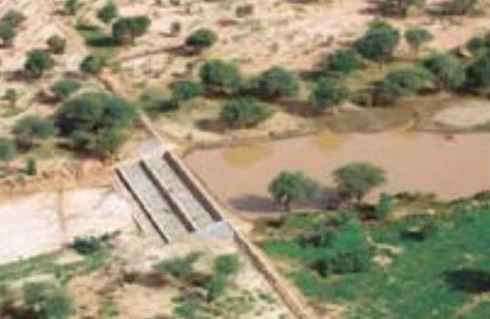
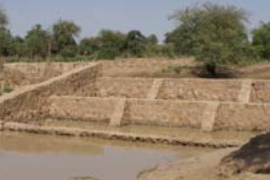
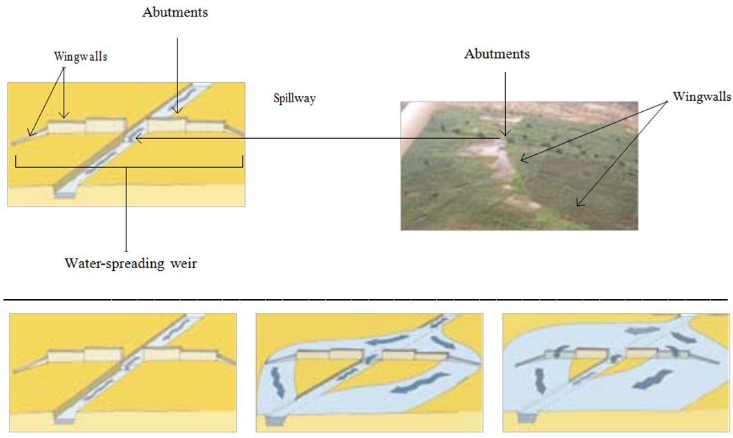
The water-spreading weir technique was developed in Burkina Faso, Niger and Chad in the late 1990s and early 2000s. They are suitable as a land improvement measure for 90% of valleys in the Sahel area. These weirs regulate floodwater in medium-sized watercourses and in wider degraded valley bottoms with a pronounced low-water channel. They are constructed with local materials and have a spillway in the middle, abutments on either side and long wingwalls to spread the water over a large area.
In order to reverse the degradation process in a valley, it is necessary to ensure the comprehensive rehabilitation of the degraded parts of the valley. This is why the technique requires an overall assessment of the valley in order to identify the causes of degradation. In order to restore the water system in a degraded valley, a series of weirs is generally required.
Water-spreading weirs slow the flow of water in valleys and spread it over a wider area where it can infiltrate into the soil. In this way, they control river floodwater, and this reduces erosion and the loss of water. At the same time, sediments improve soil fertility and replenish the water table. When water flow is low in the valley, all the water passes over the spillway. When floodwater flow is stronger, the water is channelled towards the sides and flows over the outer lower wingwalls. When the floodwaters are at their heaviest, the water flows over even the higher walls. Downstream, the waters rejoin the low-water channel. Water-spreading weirs permit the reclamation and rehabilitation of degraded land and the restoration of vegetation cover. Thanks to the weirs, water flowing through the valleys can be used for crop growing, livestock raising and forestry.
Thanks to the infiltration of considerable amounts of water, water-spreading weirs contribute to raising the water table by several metres and improving ecological conditions in adjacent areas. As a result, vegetation cover is restored, which has a positive effect on biodiversity. By 2010, German cooperation had established water-spreading weirs in Niger to improve 10,000 hectares of land in valleys. Sorghum yields increased by between 50% and 100% per ha, from 400 kg to 800 kg per ha. The production of sorghum was 10 to 15 times higher in the improved areas than it had been before. As water-spreading weirs raise the water table, areas can be developed (or abandoned farmland restored) for market gardening and horticulture, with two or three crop harvests a year. The produce is used to supplement the food available and can also be sold (especially market garden produce).
The amount of time spent by women and girls fetching water is reduced by several hours a day. Horticulture generates extra income to cover family expenses, such as education and health care. Growing crops outside the rainy season generates work all year round, which reduces temporary migration.
This technique requires accurate preliminary studies to design the system. The more degraded the valley, the more complex the work is. Improving severely degraded valleys requires extensive experience, and any necessary technical adjustments must be made when flaws are detected.
If the weirs are built to a high standard, with a certain amount of upkeep, they will last. Major repairs are beyond the means of the communities, which is why commune authorities are often assigned the role of project owner. However, this is not yet a satisfactory solution, as in most countries in the Sahel, commune authorities are still weak.
This technique has great potential for climate change adaptation in two scenarios: 1) Water-spreading weirs distribute the watershed’s water over wide areas of land in the valley bottom. This enables water resources to be used more efficiently in low-rainfall periods, during dry spells and when the rainy season ends early. 2) In high-rainfall periods and/or in the event of heavy downpours, water-spreading weirs slow the flow of water, thereby preventing or reducing gully and river bank erosion and protecting areas downstream.
2.3 รูปภาพของเทคโนโลยี
อัลบั้มสื่อบันทึก
2.5 ประเทศภูมิภาค หรือสถานที่ตั้งที่เทคโนโลยีได้นำไปใช้และได้รับการครอบคลุมโดยการประเมินนี้
ประเทศ:
มาลี
ภูมิภาค/รัฐ/จังหวัด:
Mali, Niger, Burkina Faso, Chad, Ethiopia
แสดงความคิดเห็น:
By 2010, German cooperation had established water-spreading weirs in Niger to improve 10,000 hectares of land in valleys
2.6 วันที่การดำเนินการ
ถ้าไม่รู้ปีที่แน่นอน ให้ระบุวันที่โดยประมาณ:
- 10-50 ปี
2.7 คำแนะนำของเทคโนโลยี
ให้ระบุว่าเทคโนโลยีถูกแนะนำเข้ามาอย่างไร:
- ทางโครงการหรือจากภายนอก
ความคิดเห็น (ประเภทของโครงการ เป็นต้น) :
The water-spreading weir technique was developed in Burkina Faso, Niger and Chad in the late 1990s and early 2000s.
By 2010, German cooperation had established water-spreading weirs in Niger to improve 10,000 hectares of land in valleys.
3. การจัดประเภทของเทคโนโลยี SLM
3.1 วัตถุประสงค์หลักของเทคโนโลยี
- ลด ป้องกัน ฟื้นฟู การเสื่อมโทรมของที่ดิน
3.2 ประเภทของการใช้ที่ดินในปัจจุบันที่ได้นำเทคโนโลยีไปใช้

พื้นที่ปลูกพืช
- การปลูกพืชล้มลุกอายุปีเดียว
จำนวนของฤดูเพาะปลูกต่อปี:
- 1
ระบุ:
Longest growing period in days: 120, Longest growing period from month to month: August to October

ทางน้ำ แหล่งน้ำ พื้นที่ชุ่มน้ำ
- บ่อน้ำ เขื่อน
แสดงความคิดเห็น:
Major land use problems (compiler’s opinion): soil erosion by water and wind erosion, surface runoff, lack of infiltration, fertility decline
Constraints of common grazing land
Constraints of forested government-owned land or commons
3.4 การใช้น้ำ
การใช้น้ำของที่ดินที่มีการใช้เทคโนโลยีอยู่:
- น้ำฝนร่วมกับการชลประทาน
3.5 กลุ่ม SLM ที่ตรงกับเทคโนโลยีนี้
- การจัดการด้านชลประทาน (รวมถึงการลำเลียงส่งน้ำ การระบายน้ำ)
- การผันน้ำและการระบายน้ำ
- การจัดการน้ำผิวดิน (น้ำพุ แม่น้ำทะเลสาบ ทะเล)
3.6 มาตรการ SLM ที่ประกอบกันเป็นเทคโนโลยี

มาตรการอนุรักษ์ด้วยโครงสร้าง
- S11: อื่น ๆ
แสดงความคิดเห็น:
Specification of other structural measures: water-spreading weirs
3.7 รูปแบบหลักของการเสื่อมโทรมของที่ดินที่ได้รับการแก้ไขโดยเทคโนโลยี

การกัดกร่อนของดินโดยน้ำ
- Wt (Loss of topsoil): การสูญเสียดินชั้นบนหรือการกัดกร่อนที่ผิวดิน

การกัดกร่อนของดินโดยลม
- Et (Loss of topsoil): การสูญเสียดินชั้นบน

การเสื่อมโทรมของดินทางด้านเคมี
- Cn (Fertility decline): ความอุดมสมบูรณ์และปริมาณอินทรียวัตถุในดินถูกทำให้ลดลงไป (ไม่ได้เกิดจากสาเหตุการกัดกร่อน)

การเสื่อมโทรมของดินทางด้านชีวภาพ
- Bc (Reduction of vegetation cover): การลดลงของจำนวนพืชที่ปกคลุมดิน

การเสื่อมโทรมของน้ำ
- Ha (Aridification): การเกิดความแห้งแล้ง
- Hg (Change in groundwater): การเปลี่ยนแปลงของน้ำบาดาลหรือระดับน้ำในแอ่งน้ำบาดาล
แสดงความคิดเห็น:
Main causes of degradation: crop management (annual, perennial, tree/shrub) (Unadapted landuse methods, reduced or abandoned fallow periods), floods, droughts, population pressure (rapidly growing population increasing pressure on land), land tenure (insecure access to land)
3.8 การป้องกัน การลดลง หรือการฟื้นฟูความเสื่อมโทรมของที่ดิน
ระบุเป้าหมายของเทคโนโลยีกับความเสื่อมโทรมของที่ดิน:
- ฟื้นฟูบำบัดที่ดินที่เสื่อมโทรมลงอย่างมาก
4. ข้อมูลจำเพาะด้านเทคนิค กิจกรรมการนำไปปฏิบัติใช้ ปัจจัยนำเข้า และค่าใช้จ่าย
4.1 แบบแปลนทางเทคนิคของเทคโนโลยี
ข้อมูลจำเพาะด้านเทคนิค (แบบแปลนทางเทคนิคของเทคโนโลยี):
Water-spreading weirs are constructed with local materials and have a spillway in the middle, abutments on either side and long wingwalls to spread the water over a large area.
Technical knowledge required for field staff / advisors: high
Technical knowledge required for land users: low
Main technical functions: control of dispersed runoff: impede / retard, control of concentrated runoff: impede / retard, control of concentrated runoff: drain / divert, increase of infiltration, increase / maintain water stored in soil, increase of groundwater level / recharge of groundwater, water harvesting / increase water supply, water spreading
Secondary technical functions: improvement of ground cover
Dam/ pan/ pond
Depth of ditches/pits/dams (m): 1
Length of ditches/pits/dams (m): 50-100
ผู้เขียน:
Bender (2011)
4.2 ข้อมูลทั่วไปเกี่ยวกับการคำนวณปัจจัยนำเข้าและค่าใช้จ่าย
อื่นๆ หรือสกุลเงินประจำชาติ (ระบุ):
CFA Franc
If relevant, indicate exchange rate from USD to local currency (e.g. 1 USD = 79.9 Brazilian Real): 1 USD =:
517.0
4.3 กิจกรรมเพื่อการจัดตั้ง
| กิจกรรม | Timing (season) | |
|---|---|---|
| 1. | accurate preliminary studies to design the system | |
| 2. | transport of stones | |
| 3. | construction of water-spreading weir |
4.4 ค่าใช้จ่ายของปัจจัยนำเข้าที่จำเป็นสำหรับการจัดตั้ง
| ปัจจัยนำเข้า | หน่วย | ปริมาณ | ค่าใช้จ่ายต่อหน่วย | ค่าใช้จ่ายทั้งหมดต่อปัจจัยนำเข้า | %ของค่าใช้จ่ายที่ก่อให้เกิดขึ้นโดยผู้ใช้ที่ดิน | |
|---|---|---|---|---|---|---|
| อื่น ๆ | total construction | ha | 1.0 | 2901.0 | 2901.0 | 100.0 |
| ค่าใช้จ่ายทั้งหมดของการจัดตั้งเทคโนโลยี | 2901.0 | |||||
| Total costs for establishment of the Technology in USD | 5.61 | |||||
4.5 การบำรุงรักษาสภาพหรือกิจกรรมที่เกิดขึ้นเป็นประจำ
| กิจกรรม | ช่วงระยะเวลา/ความถี่ | |
|---|---|---|
| 1. | upstream watershed development to prevent sand filling of the bottomlands | |
| 2. | any necessary technical adjustments must be made when flaws are detected |
4.7 ปัจจัยสำคัญที่สุดที่มีผลกระทบต่อค่าใช้จ่าย
ปัจจัยสำคัญที่สุดที่มีผลกระทบต่อค่าใช้จ่ายต่างๆ:
The cost of improving land with water-spreading weirs is 0.25 to 1.5 million CFA francs per hectare (2901 US Dollar per ha). Labour:
• team formed by 25 people for 2 to 3 months, depending on the size of the structure.
Lorries to transport stones:
• 150 to 200 lorryloads (skip loader – 4.5 m3 per load) at a rate of 10 to 15 lorryloads a day.
Cost of construction:
• 1 medium-sized weir 50 m long and 1 m high with 200 m long wingwalls plus basin: 15 million CFA francs
• 1 weir 100 m long and 1 m high with basin: 30 to 32 million CFA francs
• stonework: 25,000 CFA francs/m3
• basin: 15,000 CFA francs/m3.
5. สิ่งแวดล้อมทางธรรมชาติและของมนุษย์
5.1 ภูมิอากาศ
ฝนประจำปี
- < 250 ม.ม.
- 251-500 ม.ม.
- 501-750 ม.ม.
- 751-1,000 ม.ม.
- 1,001-1,500 ม.ม.
- 1,501-2,000 ม.ม.
- 2,001-3,000 ม.ม.
- 3,001-4,000 ม.ม.
- > 4,000 ม.ม.
เขตภูมิอากาศเกษตร
- กึ่งแห้งแล้ง
Thermal climate class: subtropics
5.2 สภาพภูมิประเทศ
ค่าเฉลี่ยความลาดชัน:
- ราบเรียบ (0-2%)
- ลาดที่ไม่ชัน (3-5%)
- ปานกลาง (6-10%)
- เป็นลูกคลื่น (11-15%)
- เป็นเนิน (16-30%)
- ชัน (31-60%)
- ชันมาก (>60%)
ธรณีสัณฐาน:
- ที่ราบสูง/ที่ราบ
- สันเขา
- ไหล่เขา
- ไหล่เนินเขา
- ตีนเนิน
- หุบเขา
ระดับความสูง:
- 0-100 เมตร
- 101-500 เมตร
- 501-1,000 เมตร
- 1,001-1,500 เมตร
- 1,501-2,000 เมตร
- 2,001-2,500 เมตร
- 2,501-3,000 เมตร
- 3,001-4,000 เมตร
- > 4,000 เมตร
5.3 ดิน
ค่าเฉลี่ยความลึกของดิน:
- ตื้นมาก (0-20 ซ.ม.)
- ตื้น (21-50 ซ.ม.)
- ลึกปานกลาง (51-80 ซ.ม.)
- ลึก (81-120 ซ.ม.)
- ลึกมาก (>120 ซ.ม.)
เนื้อดิน (ดินชั้นบน):
- ปานกลาง (ดินร่วน ทรายแป้ง)
- ละเอียด/หนัก (ดินเหนียว)
5.4 ความเป็นประโยชน์และคุณภาพของน้ำ
ระดับน้ำใต้ดิน:
5-50 เมตร
น้ำไหลบ่าที่ผิวดิน:
ปานกลาง
5.5 ความหลากหลายทางชีวภาพ
ความหลากหลายทางชนิดพันธุ์:
- ต่ำ
5.6 ลักษณะของผู้ใช้ที่ดินที่นำเทคโนโลยีไปปฏิบัติใช้
ระดับของความมั่งคั่งโดยเปรียบเทียบ:
- ยากจนมาก
- จน
ระดับของการใช้เครื่องจักรกล:
- งานที่ใช้แรงกาย
- การใช้กำลังจากสัตว์
เพศ:
- ชาย
ระบุลักษณะอื่นๆที่เกี่ยวข้องของผู้ใช้ที่ดิน:
Population density: 10-50 persons/km2
Annual population growth: 3% - 4% (mostly poor households below poverty line).
Off-farm income specification: men migrate temporarily or permanently to cities for off-farm income
Growing crops outside the rainy season generates work all year round, which reduces temporary migration.
5.7 Average area of land used by land users applying the Technology
- < 0.5 เฮกตาร์
- 0.5-1 เฮกตาร์
- 1-2 เฮกตาร์
- 2-5 เฮกตาร์
- 5-15 เฮกตาร์
- 15-50 เฮกตาร์
- 50-100 เฮกตาร์
- 100-500 เฮกตาร์
- 500-1,000 เฮกตาร์
- 1,000-10,000 เฮกตาร์
- >10,000 เฮกตาร์
พิจารณาว่าเป็นขนาดเล็ก กลาง หรือขนาดใหญ่ (ซึ่งอ้างอิงถึงบริบทระดับท้องถิ่น):
- ขนาดเล็ก
5.8 กรรมสิทธิ์ในที่ดิน สิทธิในการใช้ที่ดินและสิทธิในการใช้น้ำ
กรรมสิทธิ์ในที่ดิน:
- รัฐ
สิทธิในการใช้ที่ดิน:
- เกี่ยวกับชุมชน (ถูกจัดระเบียบ)
สิทธิในการใช้น้ำ:
- เกี่ยวกับชุมชน (ถูกจัดระเบียบ)
แสดงความคิดเห็น:
traditional land use rights on fields, communal land on pasture and forest land
5.9 การเข้าถึงบริการและโครงสร้างพื้นฐาน
สุขภาพ:
- จน
- ปานกลาง
- ดี
การศึกษา:
- จน
- ปานกลาง
- ดี
ความช่วยเหลือทางด้านเทคนิค:
- จน
- ปานกลาง
- ดี
การจ้างงาน (เช่น ภายนอกฟาร์ม):
- จน
- ปานกลาง
- ดี
ตลาด:
- จน
- ปานกลาง
- ดี
พลังงาน:
- จน
- ปานกลาง
- ดี
ถนนและการขนส่ง:
- จน
- ปานกลาง
- ดี
น้ำดื่มและการสุขาภิบาล:
- จน
- ปานกลาง
- ดี
บริการด้านการเงิน:
- จน
- ปานกลาง
- ดี
6. ผลกระทบและสรุปคำบอกกล่าว
6.1 ผลกระทบในพื้นที่ดำเนินการ (On-site) จากการใช้เทคโนโลยี
ผลกระทบทางด้านเศรษฐกิจและสังคม
การผลิต
การผลิตพืชผล
การผลิตพืชที่ใช้เลี้ยงปศุสัตว์
การเสี่ยงต่อความล้มเหลวในการผลิต
พื้นที่สำหรับการผลิต
ความเป็นประโยชน์และคุณภาพของน้ำ
ความต้องการน้ำจากการชลประทาน
ผลกระทบด้านสังคมวัฒนธรรมอื่น ๆ
ความมั่นคงด้านอาหาร / พึ่งตนเองได้
การบรรเทาความขัดแย้ง
contribution to human well-being
แสดงความคิดเห็น/ระบุ:
Thanks to the weirs, water flowing through the valleys can be used for crop growing, livestock raising and forestry. The amount of time spent by women and girls fetching water is reduced by several hours a day. Horticulture generates extra income to cover family expenses, such as education and health care. Growing crops outside the rainy season generates work all year round, which reduces temporary migration.
ผลกระทบด้านนิเวศวิทยา
วัฐจักรน้ำหรือน้ำบ่า
การเก็บเกี่ยวหรือการกักเก็บน้ำ
น้ำไหลบ่าที่ผิวดิน
การระบายน้ำส่วนเกิน
น้ำบาดาลหรือระดับน้ำในแอ่งน้ำบาดาล
ดิน
ความชื้นในดิน
การสูญเสียดิน
การหมุนเวียนและการเติมของธาตุอาหาร
ผลกระทบด้านนิเวศวิทยาอื่น ๆ
sand filling siltation
6.2 ผลกระทบนอกพื้นที่ดำเนินการ (Off-site) จากการใช้เทคโนโลยี
น้ำท่วมพื้นที่ท้ายน้ำ
การทับถมของดินตะกอนพื้นที่ท้ายน้ำ
6.3 การเผชิญและความตอบสนองของเทคโนโลยีต่อการเปลี่ยนแปลงสภาพภูมิอากาศที่ค่อยเป็นค่อยไป และสภาพรุนแรงของภูมิอากาศ / ภัยพิบัติ (ที่รับรู้ได้โดยผู้ใช้ที่ดิน)
การเปลี่ยนแปลงสภาพภูมิอากาศที่ค่อยเป็นค่อยไป
การเปลี่ยนแปลงสภาพภูมิอากาศที่ค่อยเป็นค่อยไป
| ฤดู | increase or decrease | เทคโนโลยีมีวิธีการรับมืออย่างไร | |
|---|---|---|---|
| อุณหภูมิประจำปี | เพิ่มขึ้น | ดี |
สภาพรุนแรงของภูมิอากาศ (ภัยพิบัติ)
ภัยพิบัติทางอุตุนิยมวิทยา
| เทคโนโลยีมีวิธีการรับมืออย่างไร | |
|---|---|
| พายุฝนประจำท้องถิ่น | ดี |
| พายุลมประจำท้องถิ่น | ดี |
ภัยพิบัติจากสภาพภูมิอากาศ
| เทคโนโลยีมีวิธีการรับมืออย่างไร | |
|---|---|
| ภัยจากฝนแล้ง | ดี |
ภัยพิบัติจากน้ำ
| เทคโนโลยีมีวิธีการรับมืออย่างไร | |
|---|---|
| น้ำท่วมตามปกติ (แม่น้ำ) | ดี |
ผลลัพธ์ตามมาที่เกี่ยวข้องกับภูมิอากาศอื่น ๆ
ผลลัพธ์ตามมาที่เกี่ยวข้องกับภูมิอากาศอื่น ๆ
| เทคโนโลยีมีวิธีการรับมืออย่างไร | |
|---|---|
| ช่วงการปลูกพืชที่ลดลงมา | ดี |
6.4 การวิเคราะห์ค่าใช้จ่ายและผลประโยชน์ที่ได้รับ
ผลประโยชน์ที่ได้รับเปรียบเทียบกับค่าใช้จ่ายในการจัดตั้งเป็นอย่างไร (จากมุมมองของผู้ใช้ที่ดิน)
ผลตอบแทนระยะสั้น:
ด้านบวก
ผลตอบแทนระยะยาว:
ด้านบวกอย่างมาก
ผลประโยชน์ที่ได้รับเปรียบเทียบกับค่าใช้จ่ายในการบำรุงรักษาหรือต้นทุนที่เกิดขึ้นซ้ำอีก เป็นอย่างไร (จากมุมมองของผู้ใช้ที่ดิน)
ผลตอบแทนระยะสั้น:
ด้านบวก
ผลตอบแทนระยะยาว:
ด้านบวกอย่างมาก
6.5 การปรับตัวของเทคโนโลยี
แสดงความคิดเห็น:
There is a little trend towards spontaneous adoption of the Technology
In most countries in the Sahel, commune authorities are still weak. Without external support, the potential for replication is very low.
6.7 จุดแข็ง / ข้อได้เปรียบ / โอกาสของเทคโนโลยี
| จุดแข็ง / ข้อได้เปรียบ / โอกาสในทัศนคติของผู้ใช้ที่ดิน |
|---|
| Growing crops outside the rainy season generates work all year round, which reduces temporary migration. |
| The amount of time spent by women and girls fetching water is reduced by several hours a day |
| If the weirs are built to a high standard, with a certain amount of upkeep, they will last |
| จุดแข็ง / ข้อได้เปรียบ / โอกาสในทัศนคติของผู้รวบรวมหรือวิทยากรหลัก |
|---|
| Water-spreading weirs permit the reclamation and rehabilitation of degraded land and the restoration of vegetation cover. Suitable as a land improvement measure for 90% of valleys in the Sahel area. |
| Slow the flow of water in valleys and spread it over a wider area where it can infiltrate into the soil. The control of river floodwater reduces erosion and the loss of water. |
| sediments improve soil fertility and replenish the water table, vegetation cover is restored |
| As water-spreading weirs raise the water table, areas can be developed (or abandoned farmland restored) for market gardening and horticulture, with two or three crop harvests a year. The produce is used to supplement the food available and can also be sold (especially market garden produce). |
| Horticulture generates extra income to cover family expenses, such as education and health care. |
6.8 จุดอ่อน / ข้อเสียเปรียบ / ความเสี่ยงของเทคโนโลยีและวิธีการแก้ไข
| จุดอ่อน / ข้อเสียเปรียบ / ความเสี่ยงในทัศนคติของผู้รวบรวมหรือวิทยากรหลัก | มีวิธีการแก้ไขได้อย่างไร |
|---|---|
| The evaluation carried out by the FICOD (investment fund for local authorities) in 2010 highlighted the serious problem of sand filling siltation in valleys when additional measures are not implemented in a watershed’s upstream areas to ensure the overall development of the whole watershed area. | To ensure that the effectiveness of water-spreading weirs is long-lasting, upstream watershed development is essential to prevent sand filling of the bottomlands. |
| Major repairs are beyond the means of the communities, which is why commune authorities are often assigned the role of project owner. However, this is not yet a satisfactory solution, as in most countries in the Sahel, commune authorities are still weak. |
7. การอ้างอิงและการเชื่อมต่อ
7.1 วิธีการและแหล่งข้อมูล
- ไปเยี่ยมชมภาคสนาม การสำรวจพื้นที่ภาคสนาม
- การสัมภาษณ์กับผู้ใช้ที่ดิน
วันที่เก็บรวบรวมข้อมูล(ภาคสนาม) :
01/07/2012
7.2 การอ้างอิงถึงสิ่งตีพิมพ์
หัวข้อ, ผู้เขียน, ปี, หมายเลข ISBN:
Good Practices in Soil and Water Conservation. A contribution to adaptation and farmers´ resilience towards climate change in the Sahel. Published by GIZ in 2012.
ชื่อเรื่อง ผู้เขียน ปี ISBN:
http://agriwaterpedia.info/wiki/Main_Page
ลิงก์และโมดูล
ขยายทั้งหมด ย่อทั้งหมดลิงก์
ไม่มีลิงก์
โมดูล
ไม่มีโมดูล