Rehabilitation of degraded lands [Ethiopia]
- Creation:
- Update:
- Compiler: Unknown User
- Editor: –
- Reviewers: Fabian Ottiger, Alexandra Gavilano
Yetegoda Meret Magegem (Amharic)
technologies_1070 - Ethiopia
View sections
Expand all Collapse all1. General information
1.2 Contact details of resource persons and institutions involved in the assessment and documentation of the Technology
1.3 Conditions regarding the use of data documented through WOCAT
The compiler and key resource person(s) accept the conditions regarding the use of data documented through WOCAT:
Ja
1.5 Reference to Questionnaire(s) on SLM Approaches (documented using WOCAT)

Incentive Based Local Level Participatory Planning Approach [Ethiopia]
The approach involves, the use of incentives to motivate particpation of communities in the planning and implementation of SWC activities which improve land productivity and income.
- Compiler: Philippe Zahner
2. Description of the SLM Technology
2.1 Short description of the Technology
Definition of the Technology:
Activities that help maintain the productive potentials of soils through prevention and reduction of erosion, enhancing of rehabilitation rate by practicing measures such as microbasins, trench, eyebrow terrace, terraces, pitting and plantation of trees.
2.2 Detailed description of the Technology
Description:
The SWC technology comprises a combination of measures, which include agronomic, vegetative, structural and management measures. This means that in implementing the SWC technology combination of measures such as contour cultivation, grass strips, soil and stone bunds, area closure and improved grazing are applied in integration to rehabilitate degraded lands and restore their productivity. The purpose is to improve food security by reducing erosion and enhance the productivity of land by planting useful trees and fodder species. Unproductive land is changed to productive land by the practicing of the technology. The SWC technology is continously maintained and improved to meet the standards and qulity such that erosion is minimized. The technology is suitable to degraded and unproductive lands which were abondoned as result of low productivity and were previously under cultivation or grazing land. Closure of the area is followed by vegetative and structural measures to speed up the recovery / regeneration rate.
2.5 Country/ region/ locations where the Technology has been applied and which are covered by this assessment
Country:
Ethiopia
Region/ State/ Province:
SNNPR
Further specification of location:
Alaba special woreda
Comments:
Total area covered by the SLM Technology is 60 km2.
Some of the SWC technology areas are well rehabilitated and the remaining sites are partially treated, because these are being newly started sites.
Map
×2.6 Date of implementation
If precise year is not known, indicate approximate date:
- more than 50 years ago (traditional)
2.7 Introduction of the Technology
Specify how the Technology was introduced:
- through projects/ external interventions
Comments (type of project, etc.):
It is introduced technology.
3. Classification of the SLM Technology
3.1 Main purpose(s) of the Technology
- improve production
- reduce, prevent, restore land degradation
3.2 Current land use type(s) where the Technology is applied
Land use mixed within the same land unit:
Ja
Specify mixed land use (crops/ grazing/ trees):
- Agro-silvopastoralism

Cropland
- Annual cropping
- Perennial (non-woody) cropping
- Tree and shrub cropping
Annual cropping - Specify crops:
- cereals - maize
- cereals - rye
- cereals - sorghum
- legumes and pulses - other
- pepper, teff, chat, haricot beans, wheat
- vetiver, elephant grass
Tree and shrub cropping - Specify crops:
- avocado
- citrus
- coffee, open grown
- mango, mangosteen, guava
- Eucalyptus, sesbania, grevillea, acacia
Number of growing seasons per year:
- 2
Specify:
Longest growing period in days: 180 Longest growing period from month to month: Apr - Sep Second longest growing period in days: 120 Second longest growing period from month to month: Jun - Sep

Grazing land
Extensive grazing:
- Semi-nomadic pastoralism
Intensive grazing/ fodder production:
- Cut-and-carry/ zero grazing

Forest/ woodlands
Products and services:
- Timber
- Fuelwood
- Fruits and nuts
- Nature conservation/ protection
Comments:
Major land use problems (compiler’s opinion): Improper landuse, defforestation, overgrazing, lack of action to control erosion.
Major land use problems (land users’ perception): lack of awarness, traditional way of ploughing, lack of technolog on SWC
Semi-nomadism / pastoralism: open grazing is practiced
Grazingland comments: Nowadays closing a small individual plots and practicing cut and carrying system is being popular among land users.
Plantation forestry: replacing natural forests
Problems / comments regarding forest use: Forest/woodlands are mainly communal, so, replanting forests is undertaken by the community. Individual forests/woodlands are very few and small in size since there is a shortage of land for forests and tree plantation.
Forest products and services: timber, fuelwood, fruits and nuts, nature conservation / protection
Type of cropping system and major crops comments: Haricot bean is planted after maize is planted and has allowed some height.
Constraints of infrastructure network (roads, railways, pipe lines, power lines)
Constraints of Stone excavation (quarrying has caused a lott of damage on land.)
3.4 Water supply
Water supply for the land on which the Technology is applied:
- rainfed
3.5 SLM group to which the Technology belongs
- improved ground/ vegetation cover
- cross-slope measure
- water harvesting
3.6 SLM measures comprising the Technology
3.7 Main types of land degradation addressed by the Technology

soil erosion by water
- Wt: loss of topsoil/ surface erosion
- Wg: gully erosion/ gullying

chemical soil deterioration
- Cn: fertility decline and reduced organic matter content (not caused by erosion)
Comments:
Main type of degradation addressed: Wt: loss of topsoil / surface erosion
Secondary types of degradation addressed: Wg: gully erosion / gullying, Cn: fertility decline and reduced organic matter content
3.8 Prevention, reduction, or restoration of land degradation
Specify the goal of the Technology with regard to land degradation:
- restore/ rehabilitate severely degraded land
Comments:
Secondary goals: prevention of land degradation, mitigation / reduction of land degradation
4. Technical specifications, implementation activities, inputs, and costs
4.1 Technical drawing of the Technology
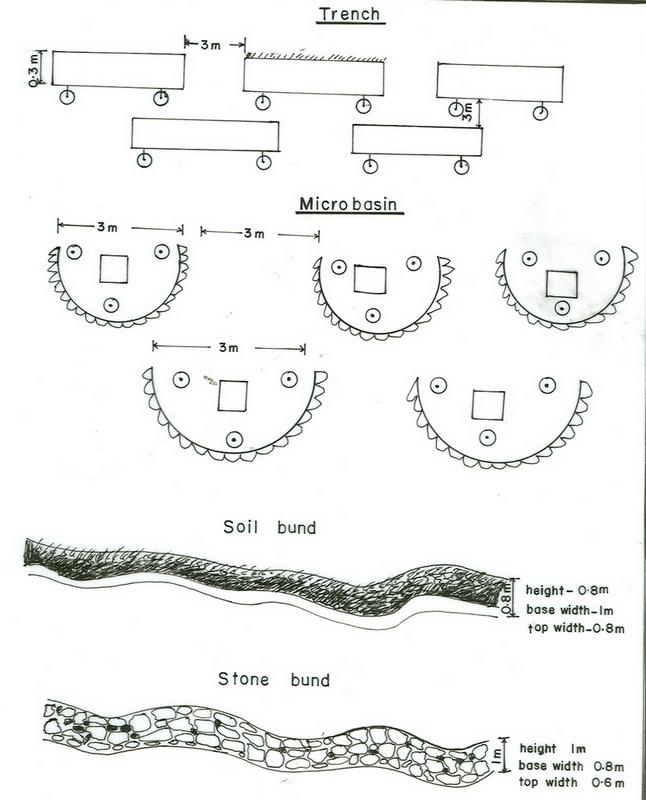
Technical specifications (related to technical drawing):
SNNPR
Technical knowledge required for field staff / advisors: high
Technical knowledge required for land users: moderate
Main technical functions: increase of infiltration, water harvesting / increase water supply
Secondary technical functions: control of raindrop splash, control of dispersed runoff: retain / trap, improvement of ground cover, increase / maintain water stored in soil, reduction in wind speed, improvement of soil structure, increase in soil fertility
Better crop cover
Material/ species: teff, wheat
Quantity/ density: 10,000,000
Remarks: broad casting
Early planting
Material/ species: maize, sorghum
Quantity/ density: 60,000
Remarks: row planting and broad casting
Relay cropping
Material/ species: maize-haricot bean
Quantity/ density: maize-hari
Remarks: row planting
Mixed cropping / intercropping
Material/ species: maize and haricot bean
Quantity/ density: 120,000
Remarks: row planting
Contour planting / strip cropping
Material/ species: maize, sorghum
Quantity/ density: 50,000
Remarks: strip cropping
Green manure
Material/ species: legumes
Quantity/ density: 100,000
Remarks: broad casting
Manure / compost / residues
Material/ species: leaves, cow dung
Mineral (inorganic) fertilizers
Material/ species: DAP, UreaTillag
Aligned: -contour
Vegetative material: G : grass
Number of plants per (ha): 10,000,000
Vertical interval between rows / strips / blocks (m): 1.5
Spacing between rows / strips / blocks (m): 0.5
Vertical interval within rows / strips / blocks (m): 0.3
Width within rows / strips / blocks (m): 0.25
Aligned: -against wind
Vegetative material: T : trees / shrubs
Number of plants per (ha): 40000
Vertical interval between rows / strips / blocks (m): 1
Spacing between rows / strips / blocks (m): 1
Vertical interval within rows / strips / blocks (m): 0.5
Width within rows / strips / blocks (m): 0.5
Scattered / dispersed
Vegetative material: F : fruit trees / shrubs
Number of plants per (ha): 111
Vertical interval between rows / strips / blocks (m): 6
Spacing between rows / strips / blocks (m): 6
In blocks
Vegetative material: T : trees / shrubs
Number of plants per (ha): 40000
Trees/ shrubs species: sesbania, grevillea, acacia
Fruit trees / shrubs species: mango, avocado, orange
Perennial crops species: coffee, chat
Grass species: vetiver, elephant grass
Slope (which determines the spacing indicated above): 8.00%
Diversion ditch/ drainage
Vertical interval between structures (m): 1
Spacing between structures (m): 50
Depth of ditches/pits/dams (m): 0.8
Width of ditches/pits/dams (m): 0.6
Length of ditches/pits/dams (m): 80
Height of bunds/banks/others (m): 0.8
Width of bunds/banks/others (m): 0.5
Length of bunds/banks/others (m): 80
Terrace: forward sloping
Vertical interval between structures (m): 1
Spacing between structures (m): 50
Depth of ditches/pits/dams (m): 0.5
Width of ditches/pits/dams (m): 0.5
Length of ditches/pits/dams (m): 10
Height of bunds/banks/others (m): 0.5
Width of bunds/banks/others (m): 1
Terrace: backward sloping
Vertical interval between structures (m): 1
Spacing between structures (m): 50
Depth of ditches/pits/dams (m): 0.5
Width of ditches/pits/dams (m): 0.5
Length of ditches/pits/dams (m): 10
Height of bunds/banks/others (m): 0.5
Width of bunds/banks/others (m): 1
Bund/ bank: level
Spacing between structures (m): 40
Depth of ditches/pits/dams (m): 0.5
Width of ditches/pits/dams (m): 1
Height of bunds/banks/others (m): 0.8
Width of bunds/banks/others (m): 1
Bund/ bank: graded
Spacing between structures (m): 20
Depth of ditches/pits/dams (m): 0.5
Width of ditches/pits/dams (m): 1
Height of bunds/banks/others (m): 0.8
Width of bunds/banks/others (m): 1
Slope (which determines the spacing indicated above): 20%
If the original slope has changed as a result of the Technology, the slope today is: 8%
Vegetation is used for stabilisation of structures.
Change of land use type: degraded land to forest land
Major change in timing of activities: structure in dry season, plantation in rainy season.
Other type of management: change of management / intensity level - protection of the closed area by site guards.
4.2 General information regarding the calculation of inputs and costs
other/ national currency (specify):
Birr
If relevant, indicate exchange rate from USD to local currency (e.g. 1 USD = 79.9 Brazilian Real): 1 USD =:
8.6
Indicate average wage cost of hired labour per day:
0.70
4.3 Establishment activities
| Activity | Timing (season) | |
|---|---|---|
| 1. | Seed collection (grass, trees) | dry season |
| 2. | Seed bed preparation | on set of rain |
| 3. | Sawing & Planting | rainy season |
| 4. | Site selection | dry season |
| 5. | participatory planning | dry season |
| 6. | Area closing | dry season |
| 7. | Trench, microbasin bund construction | dry season |
| 8. | Plantation | rain season |
| 9. | Site selection for closure area | dry period |
| 10. | Closing the degraded land | dry season |
| 11. | Construction of structural measures | onset of rains and dry seasons |
4.4 Costs and inputs needed for establishment
| Specify input | Unit | Quantity | Costs per Unit | Total costs per input | % of costs borne by land users | |
|---|---|---|---|---|---|---|
| Labour | Labour | ha | 1.0 | 387.0 | 387.0 | 26.0 |
| Equipment | Tools | ha | 1.0 | 85.0 | 85.0 | |
| Plant material | Seeds | ha | 1.0 | 33.0 | 33.0 | |
| Plant material | Seedlings | ha | 1.0 | 5.0 | 5.0 | |
| Construction material | Stone | ha | 1.0 | 2.0 | 2.0 | |
| Total costs for establishment of the Technology | 512.0 | |||||
| Total costs for establishment of the Technology in USD | 59.53 | |||||
Comments:
Duration of establishment phase: 60 month(s)
4.5 Maintenance/ recurrent activities
| Activity | Timing/ frequency | |
|---|---|---|
| 1. | Tillage/plough | dry season / annual |
| 2. | Compost making and application | before dry season / annual |
| 3. | Sawing and planting | / each cropping season |
| 4. | Plant protection | wet season / annual |
| 5. | Harvesting | dry season / each cropping season |
| 6. | Replanting | rainy season /once a year |
| 7. | Weeding | after rains /once a year |
| 8. | Cutting the matured trees | dry season /once a year |
| 9. | Replanting | rainy season/once a year |
| 10. | Reconstruction of structures | dry season/once a year |
| 11. | Planting trees | rainy season / once a year |
| 12. | plant and harvest grass | / before and after rains |
| 13. | Replanting | / once a year |
| 14. | Terench and structural measures stablization with plantation | / once in a year |
4.6 Costs and inputs needed for maintenance/ recurrent activities (per year)
| Specify input | Unit | Quantity | Costs per Unit | Total costs per input | % of costs borne by land users | |
|---|---|---|---|---|---|---|
| Labour | Labour | ha | 1.0 | 46.7 | 46.7 | 5.0 |
| Equipment | Tools | ha | 1.0 | 3.0 | 3.0 | 60.0 |
| Plant material | Seeds | ha | 1.0 | 6.6 | 6.6 | |
| Plant material | Seedlings | ha | 1.0 | 3.6 | 3.6 | 10.0 |
| Construction material | Stone | ha | 1.0 | 41.4 | 41.4 | 2.0 |
| Total costs for maintenance of the Technology | 101.3 | |||||
| Total costs for maintenance of the Technology in USD | 11.78 | |||||
Comments:
Machinery/ tools: hoe, shovel, wheel barrow, hammer
The cost is calculated for PD/person days on a hectar basis
4.7 Most important factors affecting the costs
Describe the most determinate factors affecting the costs:
Tools and transport facilities (motorcycles), fuel and food grain.
5. Natural and human environment
5.1 Climate
Annual rainfall
- < 250 mm
- 251-500 mm
- 501-750 mm
- 751-1,000 mm
- 1,001-1,500 mm
- 1,501-2,000 mm
- 2,001-3,000 mm
- 3,001-4,000 mm
- > 4,000 mm
Specifications/ comments on rainfall:
850-950 mm
Agro-climatic zone
- sub-humid
- semi-arid
5.2 Topography
Slopes on average:
- flat (0-2%)
- gentle (3-5%)
- moderate (6-10%)
- rolling (11-15%)
- hilly (16-30%)
- steep (31-60%)
- very steep (>60%)
Landforms:
- plateau/plains
- ridges
- mountain slopes
- hill slopes
- footslopes
- valley floors
Altitudinal zone:
- 0-100 m a.s.l.
- 101-500 m a.s.l.
- 501-1,000 m a.s.l.
- 1,001-1,500 m a.s.l.
- 1,501-2,000 m a.s.l.
- 2,001-2,500 m a.s.l.
- 2,501-3,000 m a.s.l.
- 3,001-4,000 m a.s.l.
- > 4,000 m a.s.l.
Comments and further specifications on topography:
Altitudinal zone: 1501-2000 m a.s.l. (ranked 1) and 2001-2500 m a.s.l. (1700-2200m a.s.l., ranked 2)
Slopes on average: Gentle (ranked 1) and moderate (ranked 2, about 70% of the land is on a slope of 2-8%)
5.3 Soils
Soil depth on average:
- very shallow (0-20 cm)
- shallow (21-50 cm)
- moderately deep (51-80 cm)
- deep (81-120 cm)
- very deep (> 120 cm)
Soil texture (topsoil):
- coarse/ light (sandy)
- medium (loamy, silty)
Topsoil organic matter:
- medium (1-3%)
If available, attach full soil description or specify the available information, e.g. soil type, soil PH/ acidity, Cation Exchange Capacity, nitrogen, salinity etc.
Soil texture: Coarse/light (ranked1) and medium (ranked 2, sandy loam)
Soil fertility: High
Soil drainage/infiltration: Good (well drained)
Soil water storage capacity: Very low (because it is sandy loam soil)
5.6 Characteristics of land users applying the Technology
Market orientation of production system:
- subsistence (self-supply)
- mixed (subsistence/ commercial)
Off-farm income:
- 10-50% of all income
Relative level of wealth:
- poor
- average
Level of mechanization:
- manual work
- animal traction
Indicate other relevant characteristics of the land users:
Population density: 200-500 persons/km2
Annual population growth: 3% - 4%
10% of the land users are very rich.
25% of the land users are rich.
40% of the land users are average wealthy.
25% of the land users are poor.
5% of the land users are poor.
Off-farm income specification: Land users who practice SWC measures get better production. Their incomes has increased compared to those who have not applied SWC.
Market orientation of cropland production system: subsistence (self-supply, part of the production is sold at local market), mixed (subsistence/ commercial)
Market orientation of grazing land production system: subsistence (self-supply, fodder plant for milk cow), mixed (subsistence/ commercial)
Market orientation of forest production system: subsistence (self-supply, tree plantation on individual plots ), mixed (subsistence/ commercial), commercial/market (plantation of a community forests)
5.7 Average area of land used by land users applying the Technology
- < 0.5 ha
- 0.5-1 ha
- 1-2 ha
- 2-5 ha
- 5-15 ha
- 15-50 ha
- 50-100 ha
- 100-500 ha
- 500-1,000 ha
- 1,000-10,000 ha
- > 10,000 ha
Comments:
Cropland: average cultivated land is about 1.5 ha/household
Grazing land: not more than 0.125 ha on average
5.8 Land ownership, land use rights, and water use rights
Land ownership:
- state
Land use rights:
- individual
6. Impacts and concluding statements
6.1 On-site impacts the Technology has shown
Socio-economic impacts
Production
crop production
fodder production
fodder quality
wood production
production area
Comments/ specify:
decrease of grazing land
Income and costs
farm income
Socio-cultural impacts
community institutions
national institutions
conflict mitigation
Ecological impacts
Water cycle/ runoff
surface runoff
Quantity before SLM:
75
Quantity after SLM:
25
Soil
soil moisture
soil cover
soil loss
Biodiversity: vegetation, animals
pest/ disease control
Climate and disaster risk reduction
wind velocity
6.2 Off-site impacts the Technology has shown
reliable and stable stream flows in dry season
Comments/ specify:
structural measures
downstream flooding
downstream siltation
6.4 Cost-benefit analysis
How do the benefits compare with the establishment costs (from land users’ perspective)?
Short-term returns:
slightly positive
Long-term returns:
positive
How do the benefits compare with the maintenance/ recurrent costs (from land users' perspective)?
Short-term returns:
positive
Long-term returns:
very positive
6.5 Adoption of the Technology
If available, quantify (no. of households and/ or area covered):
52000
Of all those who have adopted the Technology, how many did so spontaneously, i.e. without receiving any material incentives/ payments?
- 11-50%
Comments:
90% of land user families have adopted the Technology with external material support
46800 land user families have adopted the Technology with external material support
Comments on acceptance with external material support: survey results
10% of land user families have adopted the Technology without any external material support
5200 land user families have adopted the Technology without any external material support
Comments on spontaneous adoption: survey results
There is a moderate trend towards spontaneous adoption of the Technology
Comments on adoption trend: Nowadays land users have better understanding on SWC technologies, so they protect their farm land from erosion with vegetation.
6.7 Strengths/ advantages/ opportunities of the Technology
| Strengths/ advantages/ opportunities in the land user’s view |
|---|
|
SWC knoweldge is gained How can they be sustained / enhanced? through training and practical works |
|
additional income is created How can they be sustained / enhanced? diversification of SWC measures with in the same plot |
|
group work is encouraged/introduced How can they be sustained / enhanced? strengthening group formation |
|
food value has increased How can they be sustained / enhanced? from vegetables and fruits |
| Strengths/ advantages/ opportunities in the compiler’s or other key resource person’s view |
|---|
|
degraded lands are rehabilitated and covered with plantation. How can they be sustained / enhanced? through increased participatory planning approach |
|
crop production has increased. How can they be sustained / enhanced? apply more combined technologies to enhance production |
|
wood production has increased How can they be sustained / enhanced? planting multipurpose plant species increased |
|
extensive grazing is changed to intensive grazing How can they be sustained / enhanced? to some extent number of animals are reduced |
|
the community is aware of the technilogy How can they be sustained / enhanced? land users construct SWC technologies on their farm land by their own |
6.8 Weaknesses/ disadvantages/ risks of the Technology and ways of overcoming them
| Weaknesses/ disadvantages/ risks in the land user’s view | How can they be overcome? |
|---|---|
| shortage of grazing land | use cut and carry system |
| destruction of crop by wild animals | making farmers group to protect them |
| shortage of incentives | practicing more community participation works. |
7. References and links
7.1 Methods/ sources of information
Links and modules
Expand all Collapse allLinks
Incentive Based Local Level Participatory Planning Approach [Ethiopia]
The approach involves, the use of incentives to motivate particpation of communities in the planning and implementation of SWC activities which improve land productivity and income.
- Compiler: Philippe Zahner
Modules
No modules