
Terracing in Watershed [Afghanistan]
- Creation:
- Update:
- Compiler: Aqila Haidery
- Editor: –
- Reviewers: David Streiff, Alexandra Gavilano
Kordak dar Abriza
technologies_1732 - Afghanistan
View sections
Expand all Collapse all1. معلومات عامة
1.2 Contact details of resource persons and institutions involved in the assessment and documentation of the Technology
SLM specialist:
SLM specialist:
Fuleki Blanka
Helvetas
Name of the institution(s) which facilitated the documentation/ evaluation of the Technology (if relevant)
HELVETAS (Swiss Intercooperation)1.3 Conditions regarding the use of data documented through WOCAT
The compiler and key resource person(s) accept the conditions regarding the use of data documented through WOCAT:
نعم
1.5 Reference to Questionnaire(s) on SLM Approaches (documented using WOCAT)
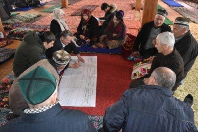
Resilient Watershed Management Plan [Tajikistan]
The participatory watershed management plan (WMP) is an interdisciplinary approach at community level to raise awareness on the watershed management concept and improve understanding of the watershed approach in planning and management of natural resource.
- Compiler: Askarsho Zevarshoev
2. Description of the SLM Technology
2.1 Short description of the Technology
Definition of the Technology:
Reshaping unproductive land into a series of levelled, gently-sloping platforms creates conditions suitable for cultivation and prevents accelerated erosion.
2.2 Detailed description of the Technology
Description:
The terracing in watershed fact-sheet is documented by Sustainable Land Management Project/HELVETAS Swiss Intercooperation which is funded by Swiss Agency for Development and Cooperation (SDC).
Due to the enduring conflict and to the breakdown of common-pool resources management in upper catchments areas over the past decades, most pastures in Afghanistan are degraded.
Uncontrolled grazing of animals tilling grazing land to grow cereal crops are the main contributors to the loss of vegetation coverage in the upper catchments. One of the negative consequences is repeated flash floods each year causing loss and damage of agriculture lands, gardens, road, canal, infrastructure, houses and even lives. To decrease the severity of flash floods and extend vegetation in upper catchment areas, HELVETAS Swiss Intercooperation in Saighan district has established watershed activities.
Purpose of the Technology: Terrace construction was identified as an effective measure in degraded watershed areas to:
•control runoff and decrease flash flood;
•increase water infiltration;
•create the opportunity for income from cultivation of valuable crops in the terraces.
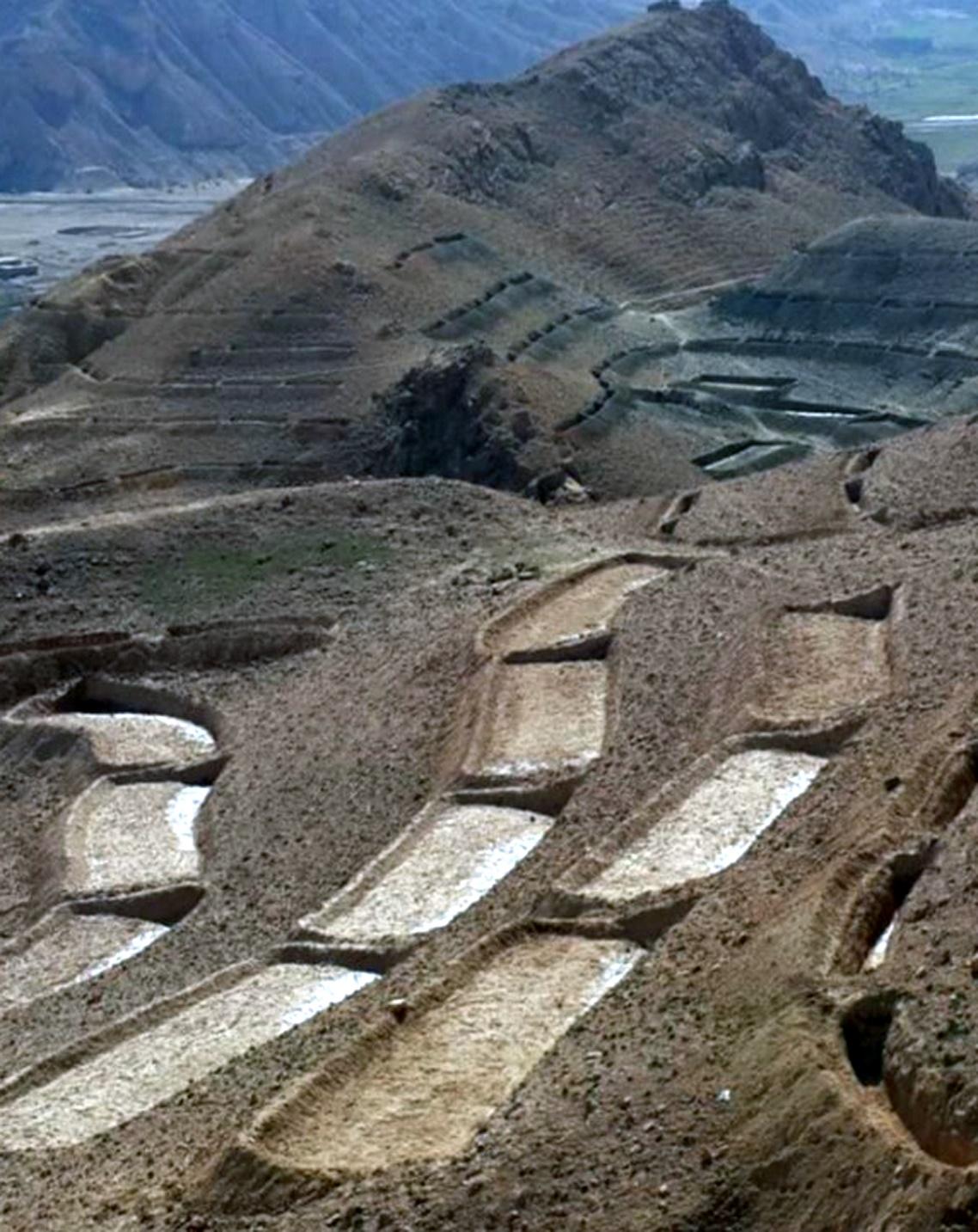
Establishment / maintenance activities and inputs: Having selected the watersheds and established watershed committees, watershed master plans were prepared and various structural and agronomical measures identified and estimated for each unit of land. Community laborers, trained by HELVETAS technical staff, constructed the terraces under supervision of watershed committee members. 600 terraces, each measuring 10 m x 3.6 m were constructed on seven hectares of land. To ensure maintenance, HELVETAS Swiss Intercooperation facilitated the creation of community saving systems and invested 10% of the project budget for maintenance of each watershed. It improved the capacity of watershed members, so after ending project support the community watershed committee would be able to manage maintenance of watershed measures.
Natural / human environment: Bamyan province is a remote province of Afghanistan with a high poverty rate. It has a semi-arid climate with cold winters and hot and dry summers. During winter, temperatures can drop below -22 degrees. Summer temperatures can reach 34 degrees in the month of July. The average annual rainfall in the area is about 230mm and some years can be very dry. 90% of the population relies on subsistence agriculture for their livelihoods and off-farm activities are marginal. The soil texture is clay, sandy loam and clay loam with moderate type of soil fertility, naked area of upper catchments causes that most of Saighan villages face to water scarcity during May to September and can’t grow valuable crops.The growing season in Saighan district is relatively short from April to October and farmers can produce only one crop per year. Farmers with access to irrigation water cultivate cash crops, for example potato and vegetables, in addition to staple crops (wheat) and fodder crops.Those without access to irrigation water cultivate wheat and fodder crops only. Water scarcity during May to September may result in a lack of high value crops.
The average annual income from one hectare in the area of having enough irrigation water is 250000 AFN (3676 USD) and in the area which has no enough irrigation water is 67500 AFN (992 USD).
2.3 Photos of the Technology
Media Gallery
2.5 Country/ region/ locations where the Technology has been applied and which are covered by this assessment
بلد:
Afghanistan
Region/ State/ Province:
Bamyan
Further specification of location:
Saighan
Specify the spread of the Technology:
- evenly spread over an area
If precise area is not known, indicate approximate area covered:
- 1-10 km2
2.6 Date of implementation
If precise year is not known, indicate approximate date:
- less than 10 years ago (recently)
2.7 Introduction of the Technology
Specify how the Technology was introduced:
- through projects/ external interventions
Comments (type of project, etc.):
Since 2010
3. Classification of the SLM Technology
3.1 Main purpose(s) of the Technology
- improve production
- reduce, prevent, restore land degradation
- reduce risk of disasters
3.2 Current land use type(s) where the Technology is applied

الأراضي الزراعية
- Perennial (non-woody) cropping
Number of growing seasons per year:
- 1
حددها:
Longest growing period in days: 120; Longest growing period from month to month: March to July

أراضي الرعي
Extensive grazing:
- Nomadism
Comments:
Major land use problems (compiler’s opinion): Harvest of shrubs and over grazing for over 20 years resulted in the lost vegetation cover. Top soil erosion is severe and gullies are visible.
Major land use problems (land users’ perception): Due to the lack of alternatives for fuel and lack of opportunities for income during decades war, people were compelled to use the natural resources in the upper catchment areas.
Future (final) land use (after implementation of SLM Technology): Cropland: Cp: Perennial (non-woody) cropping
Number of growing seasons per year: 1
Longest growing period in days: 120; Longest growing period from month to month: March to July
Livestock density: 10-25 LU /km2
3.3 Has land use changed due to the implementation of the Technology?
Has land use changed due to the implementation of the Technology?
- Yes (Please fill out the questions below with regard to the land use before implementation of the Technology)
أراضي الرعي
- Extensive grazing

Waterways, waterbodies, wetlands
3.4 Water supply
Water supply for the land on which the Technology is applied:
- rainfed
3.5 SLM group to which the Technology belongs
- cross-slope measure
3.6 SLM measures comprising the Technology

structural measures
- S1: Terraces
3.7 Main types of land degradation addressed by the Technology

soil erosion by water
- Wt: loss of topsoil/ surface erosion
Comments:
Main causes of degradation: crop management (annual, perennial, tree/shrub) (Shrub cutting), overgrazing (Over grazing and no management), droughts (3 years drought), population pressure, war and conflicts (3 decades of civil war)
3.8 Prevention, reduction, or restoration of land degradation
Specify the goal of the Technology with regard to land degradation:
- restore/ rehabilitate severely degraded land
Comments:
Secondary goals: prevention of land degradation, mitigation / reduction of land degradation
4. Technical specifications, implementation activities, inputs, and costs
4.1 Technical drawing of the Technology
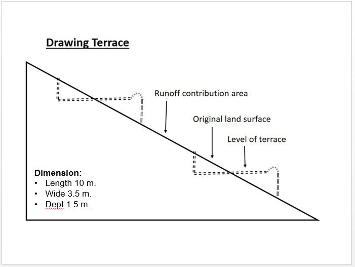
Technical specifications (related to technical drawing):
Technical drawing of a terrace built in the watershed for the mean of vegetation.
Almost all the terraces constructed on the hill sides has 10 m length, 3.5 m width and 1.5 m depth.
Location: Saighan. Bamyan
Date: 19/04/2016
Technical knowledge required for field staff / advisors: high (In order to design well)
Technical knowledge required for land users: low
Main technical functions: control of dispersed runoff: impede / retard, reduction of slope angle, reduction of slope length, improvement of topsoil structure (compaction), increase of infiltration, increase / maintain water stored in soil, promotion of vegetation species and varieties (quality, eg palatable fodder)
Terrace: forward sloping
Vertical interval between structures (m): 1.8
Spacing between structures (m): 0.5
Depth of ditches/pits/dams (m): 0.3
Width of ditches/pits/dams (m): 3.6
Length of ditches/pits/dams (m): 10
Construction material (earth): Excuvation of soil and leveling
Slope (which determines the spacing indicated above): 15-30%
If the original slope has changed as a result of the Technology, the slope today is: 0%
Lateral gradient along the structure: 0%
Specification of dams/ pans/ ponds: Capacity 36m3
Catchment area: 36m2
Author:
Shabir Shahem, HELVETAS Swiss Intercooperation, Afghanistan
4.2 General information regarding the calculation of inputs and costs
Specify currency used for cost calculations:
- USD
Indicate average wage cost of hired labour per day:
5.88
4.3 Establishment activities
| Activity | Timing (season) | |
|---|---|---|
| 1. | Labor cost for the construction of the terraces | 1 month |
4.4 Costs and inputs needed for establishment
| Specify input | Unit | Quantity | Costs per Unit | Total costs per input | % of costs borne by land users | |
|---|---|---|---|---|---|---|
| Labour | Labor cost for the construction of the terraces | persons/day | 1200,0 | 5,88 | 7056,0 | 10,0 |
| Total costs for establishment of the Technology | 7056,0 | |||||
| Total costs for establishment of the Technology in USD | 7056,0 | |||||
4.5 Maintenance/ recurrent activities
| Activity | Timing/ frequency | |
|---|---|---|
| 1. | Repairing of few terraces after heavy rain falls | 3 times a year |
4.6 Costs and inputs needed for maintenance/ recurrent activities (per year)
| Specify input | Unit | Quantity | Costs per Unit | Total costs per input | % of costs borne by land users | |
|---|---|---|---|---|---|---|
| Labour | Repairing of few terraces | persons/day | 6,0 | 5,833333 | 35,0 | 100,0 |
| Total costs for maintenance of the Technology | 35,0 | |||||
| Total costs for maintenance of the Technology in USD | 35,0 | |||||
4.7 Most important factors affecting the costs
Describe the most determinate factors affecting the costs:
Labor cost is the determinate factors which was affecting the costs.
5. Natural and human environment
5.1 Climate
Annual rainfall
- < 250 mm
- 251-500 mm
- 501-750 mm
- 751-1,000 mm
- 1,001-1,500 mm
- 1,501-2,000 mm
- 2,001-3,000 mm
- 3,001-4,000 mm
- > 4,000 mm
Agro-climatic zone
- semi-arid
Thermal climate class: temperate
5.2 Topography
Slopes on average:
- flat (0-2%)
- gentle (3-5%)
- moderate (6-10%)
- rolling (11-15%)
- hilly (16-30%)
- steep (31-60%)
- very steep (>60%)
Landforms:
- plateau/plains
- ridges
- mountain slopes
- hill slopes
- footslopes
- valley floors
Altitudinal zone:
- 0-100 m a.s.l.
- 101-500 m a.s.l.
- 501-1,000 m a.s.l.
- 1,001-1,500 m a.s.l.
- 1,501-2,000 m a.s.l.
- 2,001-2,500 m a.s.l.
- 2,501-3,000 m a.s.l.
- 3,001-4,000 m a.s.l.
- > 4,000 m a.s.l.
5.3 Soils
Soil depth on average:
- very shallow (0-20 cm)
- shallow (21-50 cm)
- moderately deep (51-80 cm)
- deep (81-120 cm)
- very deep (> 120 cm)
Soil texture (topsoil):
- medium (loamy, silty)
Topsoil organic matter:
- medium (1-3%)
If available, attach full soil description or specify the available information, e.g. soil type, soil PH/ acidity, Cation Exchange Capacity, nitrogen, salinity etc.
Soil fertility is low
Soil drainage / infiltration is medium
Soil water storage capacity is medium
5.4 Water availability and quality
Ground water table:
5-50 m
Availability of surface water:
poor/ none
Water quality (untreated):
for agricultural use only (irrigation)
5.5 Biodiversity
Species diversity:
- low
5.6 Characteristics of land users applying the Technology
Market orientation of production system:
- mixed (subsistence/ commercial)
Off-farm income:
- 10-50% of all income
Individuals or groups:
- groups/ community
Gender:
- men
Indicate other relevant characteristics of the land users:
Land users applying the Technology are mainly common / average land users
Difference in the involvement of women and men: The culture doesn't allowed women to work as labor for construction works
Population density: 10-50 persons/km2
Annual population growth: 0.5% - 1%
Relative level of wealth: rich, average, poor
10% of the land users are rich (Households who have land and livestock).
35% of the land users are average wealthy (Households who have land only).
45% of the land users are poor (Howseholds who have less or not land).
5.7 Average area of land used by land users applying the Technology
- < 0.5 ha
- 0.5-1 ha
- 1-2 ha
- 2-5 ha
- 5-15 ha
- 15-50 ha
- 50-100 ha
- 100-500 ha
- 500-1,000 ha
- 1,000-10,000 ha
- > 10,000 ha
Is this considered small-, medium- or large-scale (referring to local context)?
- large-scale
5.8 Land ownership, land use rights, and water use rights
Land ownership:
- communal/ village
Land use rights:
- communal (organized)
Water use rights:
- communal (organized)
5.9 Access to services and infrastructure
health:
- poor
- moderate
- good
education:
- poor
- moderate
- good
technical assistance:
- poor
- moderate
- good
employment (e.g. off-farm):
- poor
- moderate
- good
markets:
- poor
- moderate
- good
energy:
- poor
- moderate
- good
roads and transport:
- poor
- moderate
- good
drinking water and sanitation:
- poor
- moderate
- good
financial services:
- poor
- moderate
- good
6. Impacts and concluding statements
6.1 On-site impacts the Technology has shown
Socio-economic impacts
Production
crop production
Quantity before SLM:
60
Quantity after SLM:
80
Comments/ specify:
Technology reduce flood and lower lands doesnt effect by floods
Water availability and quality
irrigation water availability
Quantity before SLM:
20
Quantity after SLM:
25
Comments/ specify:
Increasing under ground water by applying technology
Income and costs
farm income
Quantity before SLM:
0
Quantity after SLM:
50
Comments/ specify:
Cultivation of cash crop in the terraces (farm income from uplands)
Socio-cultural impacts
food security/ self-sufficiency
SLM/ land degradation knowledge
conflict mitigation
situation of socially and economically disadvantaged groups
livelihood and human well-being
Comments/ specify:
The technology has effective role on reducing flash flood and as well through cultivation of valuable crops the community get more income from watershed area
Ecological impacts
Water cycle/ runoff
harvesting/ collection of water
surface runoff
Quantity before SLM:
0
Quantity after SLM:
100
Comments/ specify:
Leveled terraces infilter the water
groundwater table/ aquifer
Soil
soil moisture
Quantity before SLM:
0
Quantity after SLM:
50
Comments/ specify:
Technology let the water infilteration more
soil cover
soil loss
6.2 Off-site impacts the Technology has shown
water availability
downstream flooding
Quantity before SLM:
0
Quantity after SLM:
50
Comments/ specify:
Control runoff
6.3 Exposure and sensitivity of the Technology to gradual climate change and climate-related extremes/ disasters (as perceived by land users)
Gradual climate change
Gradual climate change
| Season | increase or decrease | How does the Technology cope with it? | |
|---|---|---|---|
| annual temperature | increase | well |
Climate-related extremes (disasters)
Meteorological disasters
| How does the Technology cope with it? | |
|---|---|
| local rainstorm | not well |
Climatological disasters
| How does the Technology cope with it? | |
|---|---|
| drought | well |
Hydrological disasters
| How does the Technology cope with it? | |
|---|---|
| general (river) flood | not well |
Comments:
The annual rainfall should be considered according to the slope of the area while designing terrace.
6.4 Cost-benefit analysis
How do the benefits compare with the establishment costs (from land users’ perspective)?
Short-term returns:
slightly positive
Long-term returns:
very positive
How do the benefits compare with the maintenance/ recurrent costs (from land users' perspective)?
Short-term returns:
very positive
Long-term returns:
very positive
Comments:
The establishment cost of this technology seems to be high but once they are built they need very less maintenance cost with lots of benefits in the other hand.
6.5 Adoption of the Technology
- > 50%
If available, quantify (no. of households and/ or area covered):
444 households covering 100 percent of the stated area
Of all those who have adopted the Technology, how many did so spontaneously, i.e. without receiving any material incentives/ payments?
- 0-10%
Comments:
444 land user families have adopted the Technology with external material support
There is no trend towards spontaneous adoption of the Technology
Comments on adoption trend: Construction of terraces in the watershed requires lots of investment costs.
6.7 Strengths/ advantages/ opportunities of the Technology
| Strengths/ advantages/ opportunities in the land user’s view |
|---|
|
Good measure that is easy to be applied by the people. How can they be sustained / enhanced? Conducting training and workshops for capacity building of the community members. |
|
The application of this technology results to the control of runoff and reduction of the flash flood. How can they be sustained / enhanced? More vegetative measures should be considered. |
| Strengths/ advantages/ opportunities in the compiler’s or other key resource person’s view |
|---|
|
A good technology for the better control of runoff and keeping the moisture. How can they be sustained / enhanced? Cultivation and sustainable maintenance of the plants in the terraces. |
|
Preparing and providing a good and proper place for cultivation and plantation. How can they be sustained / enhanced? Plantation of the local plants which has more resistance and are adaptable to the natural environment of Saighan district. |
|
Getting more income through cultivation of valuable crops. How can they be sustained / enhanced? Protection of cultivated seed from grazing animals |
6.8 Weaknesses/ disadvantages/ risks of the Technology and ways of overcoming them
| Weaknesses/ disadvantages/ risks in the compiler’s or other key resource person’s view | How can they be overcome? |
|---|---|
| Requires high investment and financial cost. | People should as well have contribution in the cost by providing the labor work. |
| In case the technical measures are not considered and applied properly it may increase infiltration and subsequently increases the soil moisture which may trigger landslide on slopes during rainfalls | High level of the technical staff and knowledge to be considered and as well the area should be studied and observed deeply. |
7. References and links
7.1 Methods/ sources of information
Links and modules
Expand all Collapse allLinks
Resilient Watershed Management Plan [Tajikistan]
The participatory watershed management plan (WMP) is an interdisciplinary approach at community level to raise awareness on the watershed management concept and improve understanding of the watershed approach in planning and management of natural resource.
- Compiler: Askarsho Zevarshoev
Modules
No modules