
Terracing in Watershed [Afeganistão]
- Criação:
- Atualização:
- Compilador/a: Aqila Haidery
- Editor: –
- Revisores: David Streiff, Alexandra Gavilano
Kordak dar Abriza
technologies_1732 - Afeganistão
Veja as seções
Expandir tudo Recolher tudo1. Informação geral
1.2 Detalhes do contato das pessoas capacitadas e instituições envolvidas na avaliação e documentação da tecnologia
Especialista em GST:
Especialista em GST:
Fuleki Blanka
Helvetas
Nome da(s) instituição(ões) que facilitou(ram) a documentação/ avaliação da Tecnologia (se relevante)
HELVETAS (Swiss Intercooperation)1.3 Condições em relação ao uso da informação documentada através de WOCAT
O/a compilador/a e a(s) pessoa(s) capacitada(s) aceitam as condições relativas ao uso de dados documentados através da WOCAT:
Sim
1.5 Referência ao(s) questionário(s) sobre abordagens GST (documentado(s) usando WOCAT)
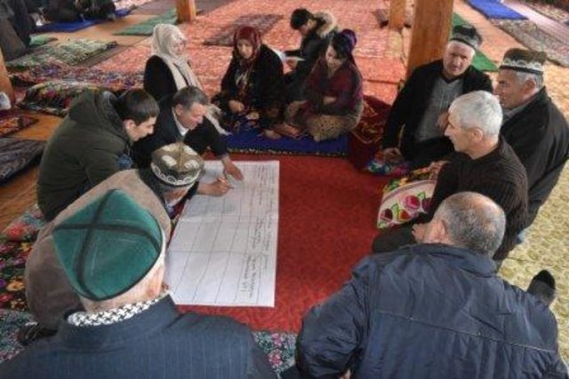
Resilient Watershed Management Plan [Tajiquistão]
The participatory watershed management plan (WMP) is an interdisciplinary approach at community level to raise awareness on the watershed management concept and improve understanding of the watershed approach in planning and management of natural resource.
- Compilador/a: Askarsho Zevarshoev
2. Descrição da tecnologia de GST
2.1 Descrição curta da tecnologia
Definição da tecnologia:
Reshaping unproductive land into a series of levelled, gently-sloping platforms creates conditions suitable for cultivation and prevents accelerated erosion.
2.2 Descrição detalhada da tecnologia
Descrição:
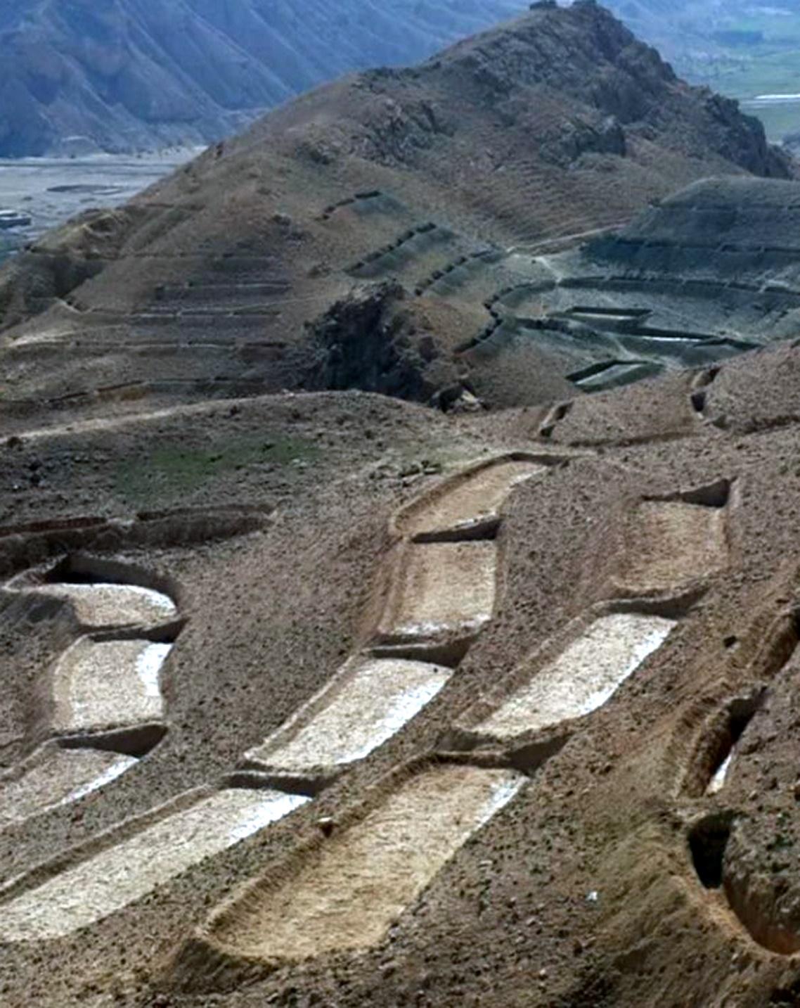
The terracing in watershed fact-sheet is documented by Sustainable Land Management Project/HELVETAS Swiss Intercooperation which is funded by Swiss Agency for Development and Cooperation (SDC).
Due to the enduring conflict and to the breakdown of common-pool resources management in upper catchments areas over the past decades, most pastures in Afghanistan are degraded.
Uncontrolled grazing of animals tilling grazing land to grow cereal crops are the main contributors to the loss of vegetation coverage in the upper catchments. One of the negative consequences is repeated flash floods each year causing loss and damage of agriculture lands, gardens, road, canal, infrastructure, houses and even lives. To decrease the severity of flash floods and extend vegetation in upper catchment areas, HELVETAS Swiss Intercooperation in Saighan district has established watershed activities.
Purpose of the Technology: Terrace construction was identified as an effective measure in degraded watershed areas to:
•control runoff and decrease flash flood;
•increase water infiltration;
•create the opportunity for income from cultivation of valuable crops in the terraces.
Establishment / maintenance activities and inputs: Having selected the watersheds and established watershed committees, watershed master plans were prepared and various structural and agronomical measures identified and estimated for each unit of land. Community laborers, trained by HELVETAS technical staff, constructed the terraces under supervision of watershed committee members. 600 terraces, each measuring 10 m x 3.6 m were constructed on seven hectares of land. To ensure maintenance, HELVETAS Swiss Intercooperation facilitated the creation of community saving systems and invested 10% of the project budget for maintenance of each watershed. It improved the capacity of watershed members, so after ending project support the community watershed committee would be able to manage maintenance of watershed measures.
Natural / human environment: Bamyan province is a remote province of Afghanistan with a high poverty rate. It has a semi-arid climate with cold winters and hot and dry summers. During winter, temperatures can drop below -22 degrees. Summer temperatures can reach 34 degrees in the month of July. The average annual rainfall in the area is about 230mm and some years can be very dry. 90% of the population relies on subsistence agriculture for their livelihoods and off-farm activities are marginal. The soil texture is clay, sandy loam and clay loam with moderate type of soil fertility, naked area of upper catchments causes that most of Saighan villages face to water scarcity during May to September and can’t grow valuable crops.The growing season in Saighan district is relatively short from April to October and farmers can produce only one crop per year. Farmers with access to irrigation water cultivate cash crops, for example potato and vegetables, in addition to staple crops (wheat) and fodder crops.Those without access to irrigation water cultivate wheat and fodder crops only. Water scarcity during May to September may result in a lack of high value crops.
The average annual income from one hectare in the area of having enough irrigation water is 250000 AFN (3676 USD) and in the area which has no enough irrigation water is 67500 AFN (992 USD).
2.3 Fotos da tecnologia
Galeria de Mídias
2.5 País/região/locais onde a tecnologia foi aplicada e que estão cobertos nesta avaliação
País:
Afeganistão
Região/Estado/Província:
Bamyan
Especificação adicional de localização:
Saighan
Especifique a difusão da tecnologia:
- Uniformemente difundida numa área
Se a área precisa não for conhecida, indicar a área aproximada coberta:
- 1-10 km2
2.6 Data da implementação
Caso o ano exato seja desconhecido, indique a data aproximada:
- menos de 10 anos atrás (recentemente)
2.7 Introdução da tecnologia
Especifique como a tecnologia foi introduzida:
- através de projetos/intervenções externas
Comentários (tipos de projeto, etc.):
Since 2010
3. Classificação da tecnologia de GST
3.1 Principal/principais finalidade(s) da tecnologia
- Melhora a produção
- Reduz, previne, recupera a degradação do solo
- Reduzir riscos de desastre
3.2 Tipo(s) atualizado(s) de uso da terra onde a tecnologia foi aplicada

Terra de cultivo
- Cultura perene (não lenhosa)
Número de estações de cultivo por ano:
- 1
Especifique:
Longest growing period in days: 120; Longest growing period from month to month: March to July

Pastagem
Pastagem extensiva:
- Nomadismo
Comentários:
Major land use problems (compiler’s opinion): Harvest of shrubs and over grazing for over 20 years resulted in the lost vegetation cover. Top soil erosion is severe and gullies are visible.
Major land use problems (land users’ perception): Due to the lack of alternatives for fuel and lack of opportunities for income during decades war, people were compelled to use the natural resources in the upper catchment areas.
Future (final) land use (after implementation of SLM Technology): Cropland: Cp: Perennial (non-woody) cropping
Number of growing seasons per year: 1
Longest growing period in days: 120; Longest growing period from month to month: March to July
Livestock density: 10-25 LU /km2
3.3 O uso do solo mudou devido à implementação da Tecnologia?
O uso do solo mudou devido à implementação da Tecnologia?
- Sim (Por favor, preencha as perguntas abaixo com relação ao uso do solo antes da implementação da Tecnologia)
Pastagem
- Extensive grazing

Vias navegáveis, corpo d'água, zonas úmidas
3.4 Abastecimento de água
Abastecimento de água para a terra na qual a tecnologia é aplicada:
- Precipitação natural
3.5 Grupo de GST ao qual pertence a tecnologia
- Medidas de curva de nível
3.6 Medidas de GST contendo a tecnologia

Medidas estruturais
- S1: Terraços
3.7 Principais tipos de degradação da terra abordados pela tecnologia

Erosão do solo pela água
- Wt: Perda do solo superficial/erosão de superfície
Comentários:
Main causes of degradation: crop management (annual, perennial, tree/shrub) (Shrub cutting), overgrazing (Over grazing and no management), droughts (3 years drought), population pressure, war and conflicts (3 decades of civil war)
3.8 Redução, prevenção ou recuperação da degradação do solo
Especifique o objetivo da tecnologia em relação a degradação da terra:
- Recuperar/reabilitar solo severamente degradado
Comentários:
Secondary goals: prevention of land degradation, mitigation / reduction of land degradation
4. Especificações técnicas, implementação de atividades, entradas e custos
4.1 Desenho técnico da tecnologia
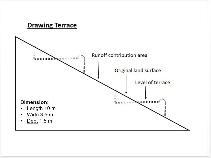
Especificações técnicas (relacionada ao desenho técnico):
Technical drawing of a terrace built in the watershed for the mean of vegetation.
Almost all the terraces constructed on the hill sides has 10 m length, 3.5 m width and 1.5 m depth.
Location: Saighan. Bamyan
Date: 19/04/2016
Technical knowledge required for field staff / advisors: high (In order to design well)
Technical knowledge required for land users: low
Main technical functions: control of dispersed runoff: impede / retard, reduction of slope angle, reduction of slope length, improvement of topsoil structure (compaction), increase of infiltration, increase / maintain water stored in soil, promotion of vegetation species and varieties (quality, eg palatable fodder)
Terrace: forward sloping
Vertical interval between structures (m): 1.8
Spacing between structures (m): 0.5
Depth of ditches/pits/dams (m): 0.3
Width of ditches/pits/dams (m): 3.6
Length of ditches/pits/dams (m): 10
Construction material (earth): Excuvation of soil and leveling
Slope (which determines the spacing indicated above): 15-30%
If the original slope has changed as a result of the Technology, the slope today is: 0%
Lateral gradient along the structure: 0%
Specification of dams/ pans/ ponds: Capacity 36m3
Catchment area: 36m2
Autor:
Shabir Shahem, HELVETAS Swiss Intercooperation, Afghanistan
4.2 Informação geral em relação ao cálculo de entradas e custos
Especifique a moeda utilizada para os cálculos de custo:
- USD
Indique a média salarial da mão-de-obra contratada por dia:
5.88
4.3 Atividades de implantação
| Atividade | Periodicidade (estação do ano) | |
|---|---|---|
| 1. | Labor cost for the construction of the terraces | 1 month |
4.4 Custos e entradas necessárias para a implantação
| Especifique a entrada | Unidade | Quantidade | Custos por unidade | Custos totais por entrada | % dos custos arcados pelos usuários da terra | |
|---|---|---|---|---|---|---|
| Mão-de-obra | Labor cost for the construction of the terraces | persons/day | 1200,0 | 5,88 | 7056,0 | 10,0 |
| Custos totais para a implantação da tecnologia | 7056,0 | |||||
| Custos totais para o estabelecimento da Tecnologia em USD | 7056,0 | |||||
4.5 Atividades recorrentes/manutenção
| Atividade | Periodicidade/frequência | |
|---|---|---|
| 1. | Repairing of few terraces after heavy rain falls | 3 times a year |
4.6 Custos e entradas necessárias pata a manutenção/atividades recorrentes (por ano)
| Especifique a entrada | Unidade | Quantidade | Custos por unidade | Custos totais por entrada | % dos custos arcados pelos usuários da terra | |
|---|---|---|---|---|---|---|
| Mão-de-obra | Repairing of few terraces | persons/day | 6,0 | 5,833333 | 35,0 | 100,0 |
| Custos totais para a manutenção da tecnologia | 35,0 | |||||
| Custos totais de manutenção da Tecnologia em USD | 35,0 | |||||
4.7 Fatores mais importantes que afetam os custos
Descreva os fatores mais determinantes que afetam os custos:
Labor cost is the determinate factors which was affecting the costs.
5. Ambiente natural e humano
5.1 Clima
Precipitação pluviométrica anual
- <250 mm
- 251-500 mm
- 501-750 mm
- 751-1.000 mm
- 1.001-1.500 mm
- 1.501-2.000 mm
- 2.001-3.000 mm
- 3.001-4.000 mm
- > 4.000 mm
Zona agroclimática
- Semiárido
Thermal climate class: temperate
5.2 Topografia
Declividade média:
- Plano (0-2%)
- Suave ondulado (3-5%)
- Ondulado (6-10%)
- Moderadamente ondulado (11-15%)
- Forte ondulado (16-30%)
- Montanhoso (31-60%)
- Escarpado (>60%)
Formas de relevo:
- Planalto/planície
- Cumes
- Encosta de serra
- Encosta de morro
- Sopés
- Fundos de vale
Zona de altitude:
- 0-100 m s.n.m.
- 101-500 m s.n.m.
- 501-1.000 m s.n.m.
- 1.001-1.500 m s.n.m.
- 1.501-2.000 m s.n.m.
- 2.001-2.500 m s.n.m.
- 2.501-3.000 m s.n.m.
- 3.001-4.000 m s.n.m.
- > 4.000 m s.n.m.
5.3 Solos
Profundidade do solo em média:
- Muito raso (0-20 cm)
- Raso (21-50 cm)
- Moderadamente profundo (51-80 cm)
- Profundo (81-120 cm)
- Muito profundo (>120 cm)
Textura do solo (solo superficial):
- Médio (limoso, siltoso)
Matéria orgânica do solo superficial:
- Médio (1-3%)
Caso disponível anexe a descrição completa do solo ou especifique as informações disponíveis, p. ex. tipo de solo, PH/acidez do solo, nitrogênio, capacidade de troca catiônica, salinidade, etc.
Soil fertility is low
Soil drainage / infiltration is medium
Soil water storage capacity is medium
5.4 Disponibilidade e qualidade de água
Lençol freático:
5-50 m
Disponibilidade de água de superfície:
Precário/nenhum
Qualidade da água (não tratada):
apenas para uso agrícola (irrigação)
5.5 Biodiversidade
Diversidade de espécies:
- Baixo
5.6 Características dos usuários da terra que utilizam a tecnologia
Orientação de mercado do sistema de produção:
- misto (subsistência/comercial)
Rendimento não agrícola:
- 10-50% de toda renda
Indivíduos ou grupos:
- Grupos/comunidade
Gênero:
- Homens
Indique outras características relevantes dos usuários da terra:
Land users applying the Technology are mainly common / average land users
Difference in the involvement of women and men: The culture doesn't allowed women to work as labor for construction works
Population density: 10-50 persons/km2
Annual population growth: 0.5% - 1%
Relative level of wealth: rich, average, poor
10% of the land users are rich (Households who have land and livestock).
35% of the land users are average wealthy (Households who have land only).
45% of the land users are poor (Howseholds who have less or not land).
5.7 Área média de terrenos utilizados pelos usuários de terrenos que aplicam a Tecnologia
- < 0,5 ha
- 0,5-1 ha
- 1-2 ha
- 2-5 ha
- 5-15 ha
- 15-50 ha
- 50-100 ha
- 100-500 ha
- 500-1.000 ha
- 1.000-10.000 ha
- > 10.000 ha
É considerado pequena, média ou grande escala (referente ao contexto local)?
- Grande escala
5.8 Propriedade de terra, direitos de uso da terra e de uso da água
Propriedade da terra:
- Comunitário/rural
Direitos do uso da terra:
- Comunitário (organizado)
Direitos do uso da água:
- Comunitário (organizado)
5.9 Acesso a serviços e infraestrutura
Saúde:
- Pobre
- Moderado
- Bom
Educação:
- Pobre
- Moderado
- Bom
Assistência técnica:
- Pobre
- Moderado
- Bom
Emprego (p. ex. não agrícola):
- Pobre
- Moderado
- Bom
Mercados:
- Pobre
- Moderado
- Bom
Energia:
- Pobre
- Moderado
- Bom
Vias e transporte:
- Pobre
- Moderado
- Bom
Água potável e saneamento:
- Pobre
- Moderado
- Bom
Serviços financeiros:
- Pobre
- Moderado
- Bom
6. Impactos e declarações finais
6.1 Impactos no local mostrados pela tecnologia
Impactos socioeconômicos
Produção
Produção agrícola
Quantidade anterior à GST:
60
Quantidade posterior à GST:
80
Comentários/especificar:
Technology reduce flood and lower lands doesnt effect by floods
Disponibilidade e qualidade de água
Disponibilidade de água para irrigação
Quantidade anterior à GST:
20
Quantidade posterior à GST:
25
Comentários/especificar:
Increasing under ground water by applying technology
Renda e custos
Rendimento agrícola
Quantidade anterior à GST:
0
Quantidade posterior à GST:
50
Comentários/especificar:
Cultivation of cash crop in the terraces (farm income from uplands)
Impactos socioculturais
Segurança alimentar/auto-suficiência
Conhecimento de GST/ degradação da terra
Atenuação de conflitos
Situação de grupos social e economicamente desfavorecidos
livelihood and human well-being
Comentários/especificar:
The technology has effective role on reducing flash flood and as well through cultivation of valuable crops the community get more income from watershed area
Impactos ecológicos
Ciclo hídrico/escoamento
Colheita/recolhimento de água
Escoamento superficial
Quantidade anterior à GST:
0
Quantidade posterior à GST:
100
Comentários/especificar:
Leveled terraces infilter the water
Lençol freático/aquífero
Solo
Umidade do solo
Quantidade anterior à GST:
0
Quantidade posterior à GST:
50
Comentários/especificar:
Technology let the water infilteration more
Cobertura do solo
Perda de solo
6.2 Impactos externos mostrados pela tecnologia
Disponibilidade de água
Cheias de jusante
Quantidade anterior à GST:
0
Quantidade posterior à GST:
50
Comentários/especificar:
Control runoff
6.3 Exposição e sensibilidade da tecnologia às mudanças climáticas graduais e extremos/desastres relacionados ao clima (conforme o ponto de vista dos usuários da terra)
Mudança climática gradual
Mudança climática gradual
| Estação do ano | aumento ou diminuição | Como a tecnologia lida com isso? | |
|---|---|---|---|
| Temperatura anual | aumento | bem |
Extremos (desastres) relacionados ao clima
Desastres meteorológicos
| Como a tecnologia lida com isso? | |
|---|---|
| Temporal local | não bem |
Desastres climatológicos
| Como a tecnologia lida com isso? | |
|---|---|
| Seca | bem |
Desastres hidrológicos
| Como a tecnologia lida com isso? | |
|---|---|
| Inundação geral (rio) | não bem |
Comentários:
The annual rainfall should be considered according to the slope of the area while designing terrace.
6.4 Análise do custo-benefício
Como os benefícios se comparam aos custos de implantação (do ponto de vista dos usuários da terra)?
Retornos a curto prazo:
levemente positivo
Retornos a longo prazo:
muito positivo
Como os benefícios se comparam aos custos recorrentes/de manutenção(do ponto de vista dos usuários da terra)?
Retornos a curto prazo:
muito positivo
Retornos a longo prazo:
muito positivo
Comentários:
The establishment cost of this technology seems to be high but once they are built they need very less maintenance cost with lots of benefits in the other hand.
6.5 Adoção da tecnologia
- > 50%
Se disponível, determine a quantidade (número de unidades familiares e/ou área abordada):
444 households covering 100 percent of the stated area
De todos aqueles que adotaram a Tecnologia, quantos o fizeram espontaneamente, ou seja, sem receber nenhum incentivo/ pagamento material?
- 0-10%
Comentários:
444 land user families have adopted the Technology with external material support
There is no trend towards spontaneous adoption of the Technology
Comments on adoption trend: Construction of terraces in the watershed requires lots of investment costs.
6.7 Pontos fortes/vantagens/oportunidades da tecnologia
| Pontos fortes/vantagens/oportunidades na visão do usuário da terra |
|---|
|
Good measure that is easy to be applied by the people. How can they be sustained / enhanced? Conducting training and workshops for capacity building of the community members. |
|
The application of this technology results to the control of runoff and reduction of the flash flood. How can they be sustained / enhanced? More vegetative measures should be considered. |
| Pontos fortes/vantagens/oportunidades na visão do/a compilador/a ou de outra pessoa capacitada |
|---|
|
A good technology for the better control of runoff and keeping the moisture. How can they be sustained / enhanced? Cultivation and sustainable maintenance of the plants in the terraces. |
|
Preparing and providing a good and proper place for cultivation and plantation. How can they be sustained / enhanced? Plantation of the local plants which has more resistance and are adaptable to the natural environment of Saighan district. |
|
Getting more income through cultivation of valuable crops. How can they be sustained / enhanced? Protection of cultivated seed from grazing animals |
6.8 Pontos fracos, desvantagens/riscos da tecnologia e formas de superá-los
| Pontos fracos/vantagens/riscos na visão do/a compilador/a ou de outra pessoa capacitada | Como eles podem ser superados? |
|---|---|
| Requires high investment and financial cost. | People should as well have contribution in the cost by providing the labor work. |
| In case the technical measures are not considered and applied properly it may increase infiltration and subsequently increases the soil moisture which may trigger landslide on slopes during rainfalls | High level of the technical staff and knowledge to be considered and as well the area should be studied and observed deeply. |
7. Referências e links
7.1 Métodos/fontes de informação
Links e módulos
Expandir tudo Recolher tudoLinks
Resilient Watershed Management Plan [Tajiquistão]
The participatory watershed management plan (WMP) is an interdisciplinary approach at community level to raise awareness on the watershed management concept and improve understanding of the watershed approach in planning and management of natural resource.
- Compilador/a: Askarsho Zevarshoev
Módulos
Não há módulos