Stone Wall Fencing and Firebreak for Forest Protection [India]
- Creation:
- Update:
- Compiler: Jaclyn Bandy
- Editor: –
- Reviewer: Hanspeter Liniger
technologies_5201 - India
View sections
Expand all Collapse all1. معلومات عامة
1.2 Contact details of resource persons and institutions involved in the assessment and documentation of the Technology
Key resource person(s)
land user:
Joshi Jagdamda
Sarpanch, Nakinia Van Panchayat (Forest Community Head)
India
Name of project which facilitated the documentation/ evaluation of the Technology (if relevant)
Onsite and Offsite Benefits of SLMName of the institution(s) which facilitated the documentation/ evaluation of the Technology (if relevant)
ICIMOD International Centre for Integrated Mountain Development (ICIMOD) - NepalName of the institution(s) which facilitated the documentation/ evaluation of the Technology (if relevant)
G.B. Pant Institute of Himalayan Einvironment & Development (G.B. Pant Institute of Himalayan Einvironment & Development) - India1.3 Conditions regarding the use of data documented through WOCAT
The compiler and key resource person(s) accept the conditions regarding the use of data documented through WOCAT:
نعم
1.4 Declaration on sustainability of the described Technology
Is the Technology described here problematic with regard to land degradation, so that it cannot be declared a sustainable land management technology?
لا
1.5 Reference to Questionnaire(s) on SLM Approaches (documented using WOCAT)

Community Forest Management in the Nakina Van Panchayat [India]
Van Panchayats or village forest councils are a impressive example of grassroots community management of natural resources, where a specific administrative unit is locally elected by community members who are responsible for the management of activities related to the forest.
- Compiler: Jaclyn Bandy
2. Description of the SLM Technology
2.1 Short description of the Technology
Definition of the Technology:
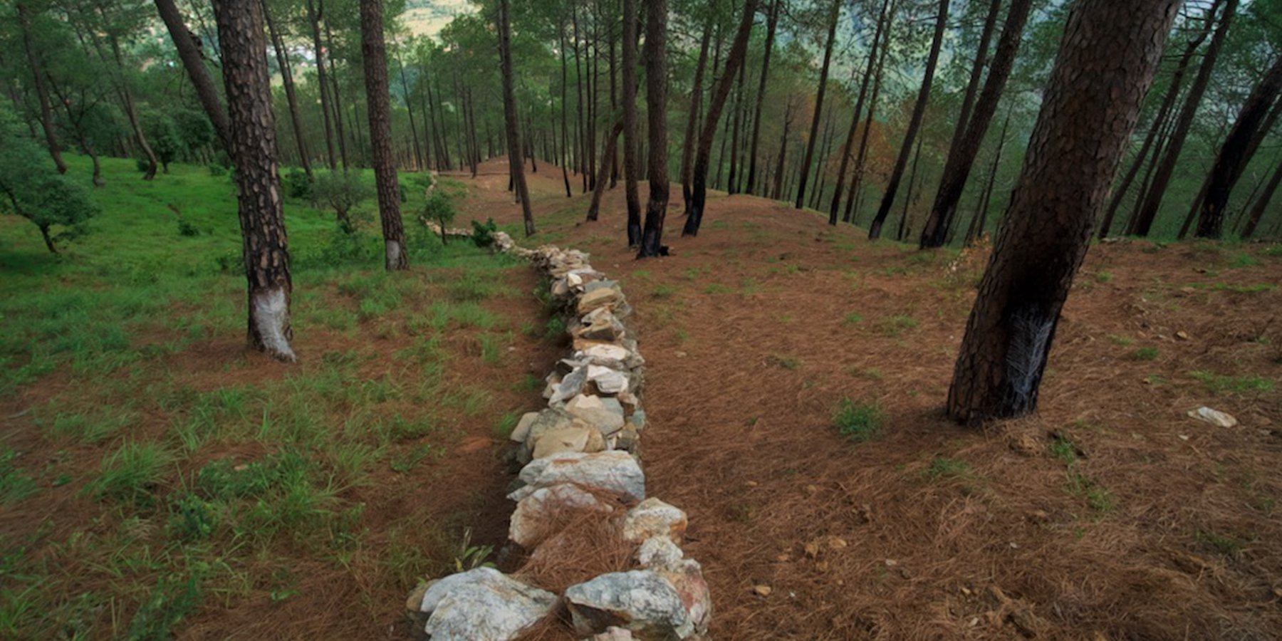
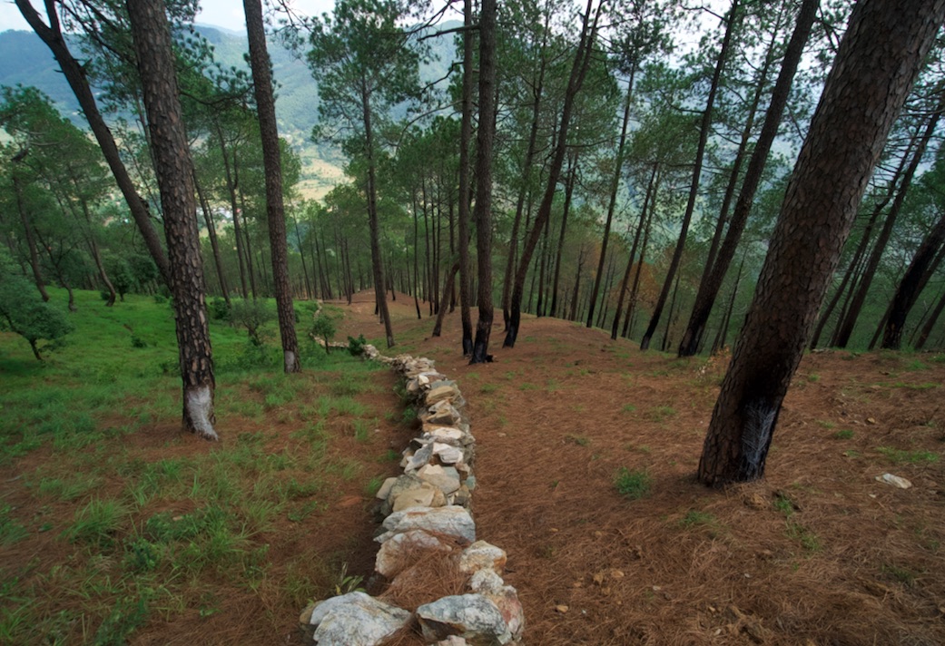
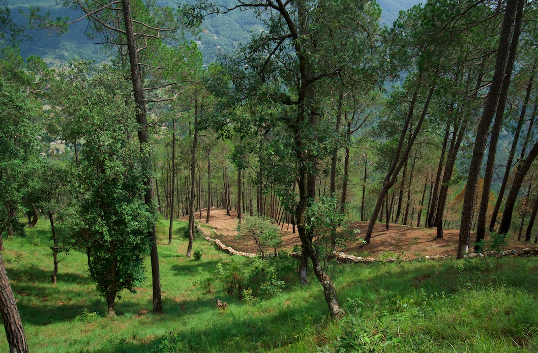
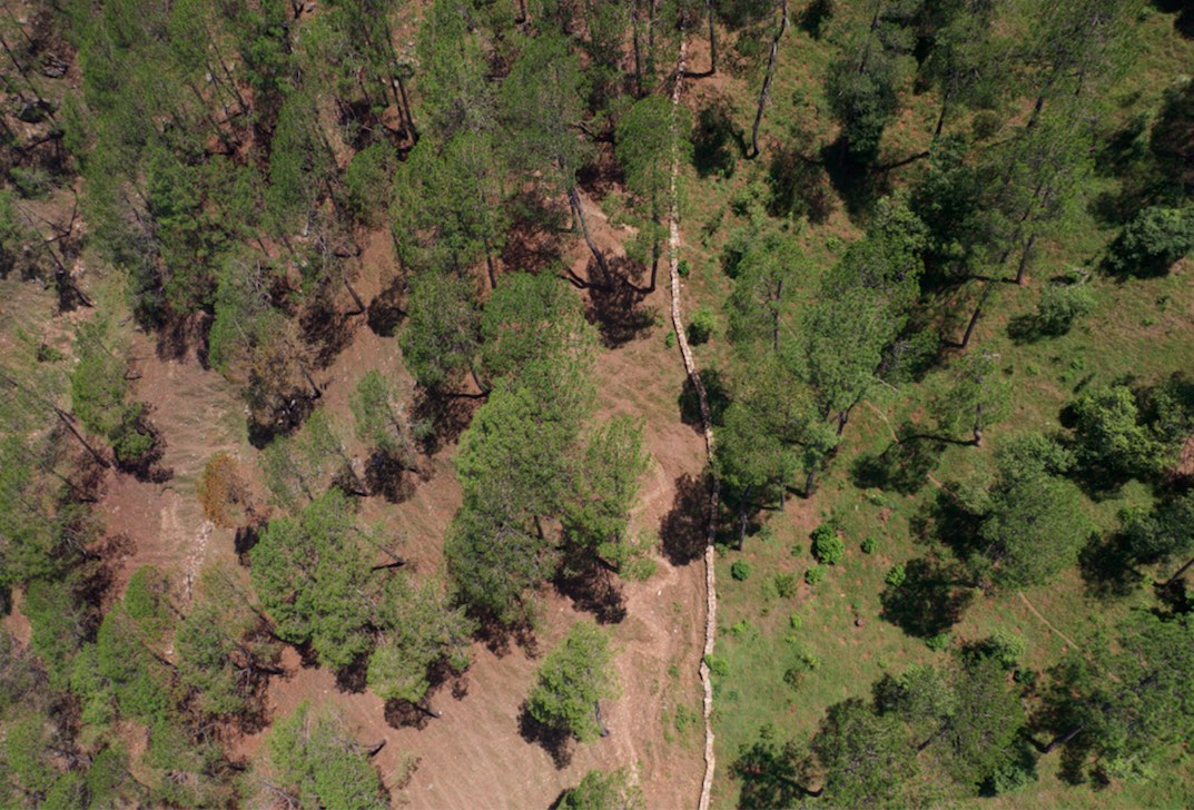
A rubble stone wall demarcates the community forest of Nakina Village and acts as a protective barrier against wildfire, wildlife, grazing, and human encroachment. The stone wall fencing is complemented by a firebreak, which is a gap of 2 meters. Firebreak establishment requires the removal of pine needles and debris from the border of the wall, so as to reduce the fuel load and possibility of fire spreading to the community forest.
2.2 Detailed description of the Technology
Description:
1. The technology has applied in the natural environment (Nakina Van Panchayat)
2. Characteristics of the technology:-
It is a dry stone wall in the community forest.
The wall (3.15km, 1m height, 80 cm width) is 40 years old and is being regularly maintained. The community is currently extending it to 4km.
3. Purpose and function of the technology:-
To protect the forest from forest fires.
To protect the fodder grasses from grazing animals
To protect the community forest from encroachment
To make a margin between two community forests.
4. Major activities and inputs needed to establish and maintain the technology:
Obtaining funding and external support to make the stone wall from other agencies (JICA, Forest Department)
The Forest department and Nakina Van Panchayat were the implementing agencies, and received approval from the District Magistrate to build the wall.
Nakina Van Panchayat organized the community people to construct the wall, paying each person 400 INR ($5.20 USD) a day for their work.
The community pooled their own construction materials and rocks were gathered on site.
5. Benefits and impacts of the Technology:
-Helps to protect forest fires from spreading to the Nakina community forest (physical barrier)
-Protect the fodder grasses from grazing animals
-Avoid conflict between two community forests and deter outsiders from crossing the wall
6. Impacts of the technology:
The wall is successful in protecting the forest from wildfire and it inhibits wildlife/livestock movements or passage.
The people of Nakina village are restricted to a particular area to collect fodder and forest products, which helps them regulate and realize their specific resource demands. This helps them avoid overexploitation of forest resources and set limits.
People views about the technology:-
Like: People are very positive about this technology and they believe that extending its length from 3.15km to 4km will further benefit the forest.
Dislike: The aesthetic of the forest is slightly compromised due to the construction wall.
During construction period, the people realized that some noise pollution from breaking stones could have disturbed neighbors grazing their livestock or other wildlife
2.3 Photos of the Technology
Media Gallery
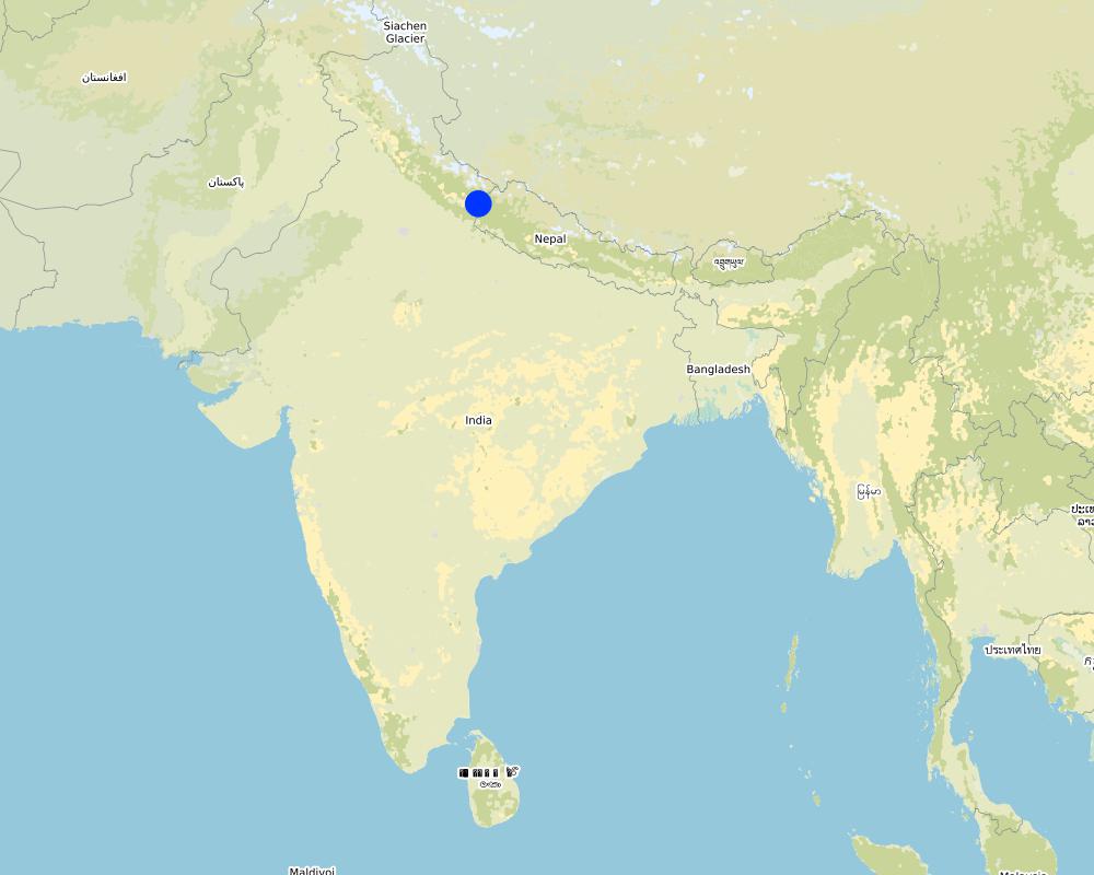
2.5 Country/ region/ locations where the Technology has been applied and which are covered by this assessment
بلد:
India
Region/ State/ Province:
Uttarakhand
Further specification of location:
Naikina Village, Pithoragarh Bloc
Specify the spread of the Technology:
- evenly spread over an area
If precise area is not known, indicate approximate area covered:
- 0.1-1 km2
Is/are the technology site(s) located in a permanently protected area?
نعم
If yes, specify:
The Nakina Van Panchayat protects 94 hectares of community forest.
Map
×2.6 Date of implementation
If precise year is not known, indicate approximate date:
- 10-50 years ago
2.7 Introduction of the Technology
Specify how the Technology was introduced:
- as part of a traditional system (> 50 years)
Comments (type of project, etc.):
The wall is about 40 years old. It is common to separate community forests through stone fencing in well-managed Van Panchayat administrations. A stonewall fence is the ideal choice in hilly areas where stones are generally available and local people are able to make it themselves.
3. Classification of the SLM Technology
3.1 Main purpose(s) of the Technology
- improve production
- reduce, prevent, restore land degradation
- conserve ecosystem
- protect a watershed/ downstream areas – in combination with other Technologies
- reduce risk of disasters
3.2 Current land use type(s) where the Technology is applied
Land use mixed within the same land unit:
نعم
Specify mixed land use (crops/ grazing/ trees):
- Silvo-pastoralism

أراضي الرعي
Intensive grazing/ fodder production:
- Cut-and-carry/ zero grazing
Animal type:
- cattle - dairy
- goats
Is integrated crop-livestock management practiced?
نعم
If yes, specify:
Manure is left or manually applied to enhance nutrient cycling of the soil and support fodder and tree growth.
Products and services:
- meat
- milk
Species:
cattle - dairy
Species:
goats

Forest/ woodlands
- Tree plantation, afforestation
Tree plantation, afforestation: Specify origin and composition of species:
- Monoculture local variety
Type of tree plantation, afforestation:
- subtropical dry forest plantation - Broadleaf
- quercus leucotrichophora, quercus glauca
Are the trees specified above deciduous or evergreen?
- deciduous
Products and services:
- Timber
- Fuelwood
- Grazing/ browsing
3.3 Has land use changed due to the implementation of the Technology?
Has land use changed due to the implementation of the Technology?
- Yes (Please fill out the questions below with regard to the land use before implementation of the Technology)
Land use mixed within the same land unit:
نعم
Specify mixed land use (crops/ grazing/ trees):
- Silvo-pastoralism
أراضي الرعي
Extensive grazing:
- Semi-nomadic pastoralism
Animal type:
- cattle - dairy
- cattle - non-dairy working
- goats
Is integrated crop-livestock management practiced?
نعم
If yes, specify:
Manure is left or manually applied to enhance nutrient cycling of the soil and support fodder and tree growth.
Products and services:
- meat
- milk
Species:
cattle - dairy
Species:
goats
Forest/ woodlands
- Tree plantation, afforestation
Tree plantation, afforestation: Specify origin and composition of species:
- Monoculture local variety
Type of tree plantation, afforestation:
- subtropical dry forest plantation - Broadleaf
- quercus leucotrichophora, quercus glauca
Are the trees specified above deciduous or evergreen?
- deciduous
Products and services:
- Timber
- Fuelwood
- Grazing/ browsing
Comments:
Before the Van Panchayat was established (1952), there was grazing in the forest. Additionally, before the wall was constructed (1979), there was encroachment of livestock belonging to other villagers in the Nakina forest.
3.4 Water supply
Water supply for the land on which the Technology is applied:
- rainfed
3.5 SLM group to which the Technology belongs
- natural and semi-natural forest management
3.6 SLM measures comprising the Technology

structural measures
- S6: Walls, barriers, palisades, fences

management measures
- M1: Change of land use type
- M2: Change of management/ intensity level
3.7 Main types of land degradation addressed by the Technology

soil erosion by water
- Wt: loss of topsoil/ surface erosion
- Wg: gully erosion/ gullying
- Wm: mass movements/ landslides

biological degradation
- Bc: reduction of vegetation cover
- Bh: loss of habitats
- Bq: quantity/ biomass decline
- Bf: detrimental effects of fires
- Bs: quality and species composition/ diversity decline
- Bl: loss of soil life
Comments:
Soil erosion by water: The wall supports the forest and protected, diverse understory. Thereby, it supports infiltration, decreases runoff and its corresponding damages.
3.8 Prevention, reduction, or restoration of land degradation
Specify the goal of the Technology with regard to land degradation:
- prevent land degradation
- reduce land degradation
4. Technical specifications, implementation activities, inputs, and costs
4.1 Technical drawing of the Technology
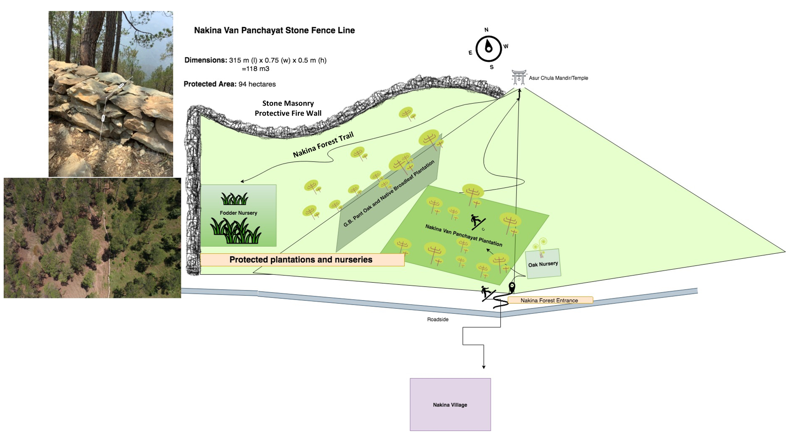
Technical specifications (related to technical drawing):
Length: 3.15 km
315 m (l) x 0.75 (w) x 0.5 m (h) = 118 m3
Firebreak: 2m of littler is cleared on each side of the wall (1x per year during the dry season, after pine needles drop in April/May)
Author:
Jaclyn Bandy
Date:
22/08/2019
4.2 General information regarding the calculation of inputs and costs
Specify how costs and inputs were calculated:
- per Technology unit
Specify unit:
Protective stone wall
Specify dimensions of unit (if relevant):
3.15 km
other/ national currency (specify):
INR
If relevant, indicate exchange rate from USD to local currency (e.g. 1 USD = 79.9 Brazilian Real): 1 USD =:
70,0
Indicate average wage cost of hired labour per day:
400 INR / person
4.3 Establishment activities
| Activity | Timing (season) | |
|---|---|---|
| 1. | Agreement between Nakina Van Panchayat, JICA and Forest Department for project implementation | Winter |
| 2. | Wall Preparation: Site demarcation, clearing of brush, vegetation, collection of stones | Winter |
| 3. | Random rubble stones of all shapes and sizes are chiseled; inconvenient edges are chipped off | Winter |
| 4. | Stones are piled on top of one another without mortar, and laid in irregular horizontal courses. | Winter |
| 5. | Regular monitoring by administrative committee on the construction site | Year round |
| 6. | Clearing dry pine needles around the dry stone (2m on each side of the wall) annually in the dry season. | April/May |
4.4 Costs and inputs needed for establishment
| Specify input | Unit | Quantity | Costs per Unit | Total costs per input | % of costs borne by land users | |
|---|---|---|---|---|---|---|
| Labour | Unskilled, semi-skilled work (community) | person/day | 4200,0 | 400,0 | 1680000,0 | 100,0 |
| Labour | Skilled (technical experts, trained construction workers) | person/day | 50,0 | 2000,0 | 100000,0 | 100,0 |
| Equipment | Pick | pieces | 15,0 | 300,0 | 4500,0 | 100,0 |
| Equipment | shovel | pieces | 20,0 | 500,0 | 10000,0 | 100,0 |
| Equipment | pharuwa (hoe) | pieces | 15,0 | 300,0 | 4500,0 | 100,0 |
| Equipment | khanti (digging bar) | pieces | 10,0 | 1500,0 | 15000,0 | 100,0 |
| Equipment | hammer (5kg) | pieces | 10,0 | 2000,0 | 20000,0 | 100,0 |
| Equipment | chino (chisel) | pieces | 10,0 | 500,0 | 5000,0 | 100,0 |
| Equipment | Khukuri (knife) | pieces | 10,0 | 250,0 | 2500,0 | 100,0 |
| Equipment | Small hammer (0.5-1kg) | pieces | 15,0 | 300,0 | 4500,0 | 100,0 |
| Total costs for establishment of the Technology | 1846000,0 | |||||
| Total costs for establishment of the Technology in USD | 26371,43 | |||||
Comments:
Calculation for Labor: 0.75m/person/day
Hired Labor/Day: 30 people
Total Wall Construction/Day: 22.5m/day
Time: 3.15 km (3,150m) / 22.5 = 140 days (~ 5month)
Unit = 4200 (140x 30 people)
4.5 Maintenance/ recurrent activities
| Activity | Timing/ frequency | |
|---|---|---|
| 1. | Maintaining small damages to wall structure | Year-round |
| 2. | Emergency tending to large sites of damage | Monsoon |
| 3. | Frequent visitations during the dry season/fire season | Pre monsoon |
| 4. | Firebreak establishment: clearing of pine needs 2m on each side of the wall | Peak Dry season |
Comments:
The local people establish a firebreak (2m pine needle/brush clearance) from both sides of the wall. The labor cost is taken up by the community, which is a voluntary action.
4.6 Costs and inputs needed for maintenance/ recurrent activities (per year)
| Specify input | Unit | Quantity | Costs per Unit | Total costs per input | % of costs borne by land users | |
|---|---|---|---|---|---|---|
| Labour | Unskilled/semiskilled | person-days | 100,0 | 400,0 | 40000,0 | 100,0 |
| Labour | Skilled | person-days | 10,0 | 2000,0 | 20000,0 | 100,0 |
| Equipment | Picks | pieces | 10,0 | 300,0 | 3000,0 | 100,0 |
| Equipment | Shovel | pieces | 10,0 | 500,0 | 5000,0 | 100,0 |
| Equipment | pharuwa (hoe) | pieces | 7,0 | 300,0 | 2100,0 | 100,0 |
| Equipment | khanti (digging bar) | pieces | 7,0 | 1500,0 | 10500,0 | 100,0 |
| Equipment | hammer | pieces | 5,0 | 2000,0 | 10000,0 | 100,0 |
| Equipment | chino (chisel) | pieces | 9,0 | 500,0 | 4500,0 | 100,0 |
| Equipment | khukuri (knife) | pieces | 5,0 | 250,0 | 1250,0 | 100,0 |
| Equipment | small hammer | pieces | 15,0 | 300,0 | 4500,0 | 100,0 |
| Total costs for maintenance of the Technology | 100850,0 | |||||
| Total costs for maintenance of the Technology in USD | 1440,71 | |||||
If land user bore less than 100% of costs, indicate who covered the remaining costs:
Uttarakhand Forest Department, JICA
Comments:
The costs of extending the wall to 4km are included in the maintenance costs. "Unskilled laborers" or villagers are payed by the communal funds contributed to the Nakina Van Panchayat.
There is however some remaining financial support from JICA/Uttarakhand Forest Department to maintain the wall (e.g. money to cover the replacement of broken or stolen tools) and technical engineer who comes for periodic checks on the construction progress.
For the current wall extension, the land users are paid by the funds and colletive savings managed by the Nakina Van Panchayat.
4.7 Most important factors affecting the costs
Describe the most determinate factors affecting the costs:
Labor availability, extent of structural damage to the wall
5. Natural and human environment
5.1 Climate
Annual rainfall
- < 250 mm
- 251-500 mm
- 501-750 mm
- 751-1,000 mm
- 1,001-1,500 mm
- 1,501-2,000 mm
- 2,001-3,000 mm
- 3,001-4,000 mm
- > 4,000 mm
Specify average annual rainfall (if known), in mm:
1500,00
Specifications/ comments on rainfall:
Monsoon- mid-June to mid-September; July and August are the rainiest months and the temperature is warm and moist; between 70-85% of the annual precipitation occurs in the monsoon season
Indicate the name of the reference meteorological station considered:
India Meteorological Department, Meteorological Centre Dehradun
Agro-climatic zone
- sub-humid
The overall climatic condition in the Pithoragarh district is governed by the southwest monsoon. It has a sub-tropical to temperate climate, with three pronounced seasons; summer, winter, and monsoon. The hilly terrain of the Himalayan region has snow cover and is cold during winter with snowfall normally occurring during the months of December to March.
Temperature- The temperature ranges from 0°C to 10°C in winter and from 8°C to 33°C in summer season. However, there is no meteorological observatory in the district. The account of the climate is based mainly on the records of the observations in the neighboring districts where similar meteorological conditions prevail. Variations in temperature are considerable from place to place and depend upon elevation as well as aspect. As the insolation is intense at high altitudes, in summer temperatures are considerably higher in the open than in the shade.
5.2 Topography
Slopes on average:
- flat (0-2%)
- gentle (3-5%)
- moderate (6-10%)
- rolling (11-15%)
- hilly (16-30%)
- steep (31-60%)
- very steep (>60%)
Landforms:
- plateau/plains
- ridges
- mountain slopes
- hill slopes
- footslopes
- valley floors
Altitudinal zone:
- 0-100 m a.s.l.
- 101-500 m a.s.l.
- 501-1,000 m a.s.l.
- 1,001-1,500 m a.s.l.
- 1,501-2,000 m a.s.l.
- 2,001-2,500 m a.s.l.
- 2,501-3,000 m a.s.l.
- 3,001-4,000 m a.s.l.
- > 4,000 m a.s.l.
Indicate if the Technology is specifically applied in:
- concave situations
Comments and further specifications on topography:
Average Altitude of evaluated sites: 1990m
Average Slope: 28%
5.3 Soils
Soil depth on average:
- very shallow (0-20 cm)
- shallow (21-50 cm)
- moderately deep (51-80 cm)
- deep (81-120 cm)
- very deep (> 120 cm)
Soil texture (topsoil):
- coarse/ light (sandy)
- medium (loamy, silty)
Soil texture (> 20 cm below surface):
- medium (loamy, silty)
Topsoil organic matter:
- medium (1-3%)
- low (<1%)
If available, attach full soil description or specify the available information, e.g. soil type, soil PH/ acidity, Cation Exchange Capacity, nitrogen, salinity etc.
Mountain/hill soils are a collective name given to various types of soils found under the following conditions :
-under sub-tropical, temperate and sub-alpine conditions
-under various forest types
Characteristics: very thin, fertile, and may be less than a centimeter deep on steep slopes; they are mixed with pebbles, shingles (a mass of small rounded pebbles), and gravels; they have a low-medium water holding capacity. Angular and subangular fragments of parent rock may be found mixed with the lower layers of the mountain and hill soils.
Texture: varies from loamy to sandy loam.
Soil Reaction: ranges from acidic to neutral (pH 4.6 to 6.5)
Organic Matter content: 1-5%
Ferrugenous red roils are found in this district and are well developed over Himalayan rocks (quartzite, biotite schist, amphibolite schist). They are free of carbonates and deficient in nitrogen, humus and phosphorus, light textured, porous, and friable (brittle/crumbly). The soil depth ranges from about 10cm-75 cm. These soils may be grouped into two on basis of morphology
1. Red earths- loose, friable topsoil rich in secondary concretions (hard, compact mass of matter formed by the precipitation of mineral cement within the spaces between particles, and is found in sedimentary rock or soil)
2. Red loam- argillaceous soils having a blocky structure (argillaceous minerals may appear silvery upon optical reflection and are minerals containing substantial amounts of clay-like components, e.g. argillaceous limestones are limestones consisting predominantly of calcium carbonate, but including 10-40% of clay minerals)
Brown soil: is found particularly under dense broadleaved temperate and sub-alpine forests. There occurs a thick layer of humus on the forest floor (made of decomposed leaves, branches, twigs) and the topsoil is extremely rich in humus
Podsolic Soil: soil that has developed in humid/temperate conditions usually under coniferous forests (e.g. deodar, blue pine, fir, spruce) over quartzite, granites, schists and gneiss.
5.4 Water availability and quality
Ground water table:
5-50 m
Availability of surface water:
medium
Water quality (untreated):
good drinking water
Water quality refers to:
ground water
Is water salinity a problem?
لا
Is flooding of the area occurring?
لا
Comments and further specifications on water quality and quantity:
Quantity: Water crisis has been a perennial problem in both the rural and urban areas of the Pithoragarh district
There is scarcity of safe drinking water of the villages in the study area. Hand pumps are often not functioning, pipe-water schemes are unreliable and the spring discharges have reduced during the dry season. Hand-pumped water often has a high iron content and bitter taste. Poor quality of groundwater in some of the naulas is mainly due to misuse and/or disuse of the structures.
A block-district groundwater resource estimation could not be carried out as the area is hilly (with slope >20%) and in major part aquifers are small, isolated bodies, and groundwater abstraction is done mainly through hand pumps and springs with small discharges.
However, we collected some physicochemical parameters that indicate the water (sourced from springs) is of good quality:
Water Quality Parameters of Springs:
pH: 6.29-8.18
Temp: 19.0-23.5 ºC
Electrical Conductivity: 109-504 µmsiemens
Total Dissolved Solids: 75-385 ppm
Other Parameters (from springs of nearby district, Champawat)
Electrical Conductivity: 127-222 µmsiemens
pH: 7.69-8.24
Calcium: 16-36 mg/l
Magnesium: 4.9-7.3 mg/l
Bicarbonate: 61-134 mg/l
Chloride: 5.3- 8.9 mg/l
Total Hardness as CaCO3: 70-110 mg/l
Source: Government of India Ministry of Water Resources, Central Ground Water Board, 2009 Groundwater Brochure of Champawat District (2009)
5.5 Biodiversity
Species diversity:
- medium
Habitat diversity:
- medium
Comments and further specifications on biodiversity:
Uttarakhand has more than 7000 species of medicinal plants and 500 species of fauna. Floral diversity contributes 31% of total floral density of India. Fauna contributes just 1.58% of the total faunal density of the country. There are 119 endemic species of flowering plants in the state that exhibited 2.35% endemism and 35 faunal endemic species. Because it lies at the juncture of India, Nepal and the Tibeten Autononmous region, there often cases of poaching and smuggling of wildlife contrabands, including bear bile, musk pods and leopard skins through the borders. Yarsa Gumba Ophiocordyceps sinensis, commonly known as Caterpillar Fungus, is also illegally traded transboundary in the region, together with various plant species. Due to anthropogenic impacts, changes is soil quality, and climatic elements, the biodiversity of our study site is not as high as in other areas of the Pithoragarh district.
Citation: Sundriyal, M. & Sharma, B. (2016). Status of Biodiversity in Central Himalaya, Applied Ecology and Environmental Sciences, 4( 2), 37-43.
5.6 Characteristics of land users applying the Technology
Sedentary or nomadic:
- Sedentary
Market orientation of production system:
- subsistence (self-supply)
- mixed (subsistence/ commercial)
Off-farm income:
- 10-50% of all income
Relative level of wealth:
- poor
Individuals or groups:
- groups/ community
Level of mechanization:
- manual work
Gender:
- women
- men
Age of land users:
- youth
- middle-aged
- elderly
Indicate other relevant characteristics of the land users:
With recent development in Pithoragarh, an influx of funds coming from outside sources has caused a decline in the importance of agriculture production, which in now marginalized, based on female labour, and mainly conducted for subsistence with little surplus to sell. High caste men do not work in cultivation at all, and male tasks such as ploughing are performed by the Scheduled Caste.
Although most women are still cultivating, their work has lost economic importance. For most families, the produce does not cover the needs of the household and surplus must be bought from the market. Many of the terraces that were formerly fruit orchards (mainly citrus) have been completely abandoned. Farming is less intensive and landholdings are small and fragmented. The main crops are wheat, millet, and pulses, but yields are low as the land is not irrigated. Less livestock (cows, goats, buffalo) is kept because of the labor involved. Very little capital is returned to farming. Crops produced for the markets in the plains are replacing traditional crops to sustain the household.
With exposure to the“Modern” lifestyle, new values have also been accepted. Two children are the norm (the ideal being one son and one daughter, but at least one son in a must). Although access to education is quite good, it does not seem to result in working careers for women.
5.7 Average area of land used by land users applying the Technology
- < 0.5 ha
- 0.5-1 ha
- 1-2 ha
- 2-5 ha
- 5-15 ha
- 15-50 ha
- 50-100 ha
- 100-500 ha
- 500-1,000 ha
- 1,000-10,000 ha
- > 10,000 ha
Is this considered small-, medium- or large-scale (referring to local context)?
- small-scale
5.8 Land ownership, land use rights, and water use rights
Land ownership:
- communal/ village
Land use rights:
- communal (organized)
Water use rights:
- open access (unorganized)
- communal (organized)
Are land use rights based on a traditional legal system?
نعم
حددها:
Under the Kumaun Panchayat forest rules of 1931 (amended in 1976): A Van Panchayat, (community forest council), can be formed out of non-private land within the settlement boundaries of a village. Accordingly, all villagers are members of the VP upon their approval by a Sub-Divisional Magistrate under the state Revenue Department. The members are collectively referred to as the general body, which selects the management committee members through a democratic process.
Comments:
5-9 elected members assume control and regulation of forest resources. They additionally raise funds and mobilize the village to protect and support sustainable land use. Presently 12,089 Van Panchayats are entrusted with the management of over 5,449.64 km2 of forests.
5.9 Access to services and infrastructure
health:
- poor
- moderate
- good
education:
- poor
- moderate
- good
technical assistance:
- poor
- moderate
- good
employment (e.g. off-farm):
- poor
- moderate
- good
markets:
- poor
- moderate
- good
energy:
- poor
- moderate
- good
roads and transport:
- poor
- moderate
- good
drinking water and sanitation:
- poor
- moderate
- good
financial services:
- poor
- moderate
- good
Comments:
The situation of infrastructure is difficult and inconsistent in the hill regions because of the terrain. The major infrastructural issues are drinking water and irrigation facilities, electricity, transportation and communication facilities and social infrastructure (housing and education). As for financial services, only the State Bank of India (SBI) is active in the hill regions where it is trying to achieve the objective of 100% financial inclusion. Some villages mentioned buying into into agricultural insurance in the past, however this was a temporary enterprise and they were never compensated after extreme climatic events that occurred and damaged over 70% of their crop.
Though infrastructure and education has generally improved over the years, institutional and marketing networks in the region aimed at supporting hill-farmers are lacking.
6. Impacts and concluding statements
6.1 On-site impacts the Technology has shown
Socio-economic impacts
Production
fodder production
Quantity before SLM:
2 ton/hectare
Quantity after SLM:
10 ton/hectare
fodder quality
Comments/ specify:
More broadleaf species
wood production
Comments/ specify:
Fuelwood from broadleaved species is more plentiful
forest/ woodland quality
Comments/ specify:
Less pine encroachment and fire damage, tree lopping for fodder decreased by 15%
non-wood forest production
Comments/ specify:
Resin collection has increased, pines residing in the protected forest are not damaged by the fire
production area
Comments/ specify:
Rehabilitated areas that had previously been barren or overgrazed
land management
Comments/ specify:
Less dispute over land resources with a clear demarcation
Water availability and quality
water availability for livestock
Income and costs
expenses on agricultural inputs
Comments/ specify:
Less damage to plantation and fodder grasses, improved survivability of saplings and decreased costs of supplementary fodder
economic disparities
Comments/ specify:
Decreased fodder availability gap during dry season
workload
Comments/ specify:
Women have saved approximately 1-2 hours in fodder collection
Socio-cultural impacts
food security/ self-sufficiency
Comments/ specify:
Milk production of the livestock has increased due to improved fodder availability/quality
land use/ water rights
cultural opportunities
Comments/ specify:
Improved forest quality and aesthetic of forest surrounding the temple
recreational opportunities
community institutions
SLM/ land degradation knowledge
Comments/ specify:
Increased attention to landscape features and execution of SLM interventions within the community and Van Panchayat
conflict mitigation
situation of socially and economically disadvantaged groups
Ecological impacts
Water cycle/ runoff
water quantity
Comments/ specify:
Improved infiltration and soil WHC
harvesting/ collection of water
surface runoff
groundwater table/ aquifer
evaporation
Soil
soil moisture
soil cover
soil loss
soil accumulation
soil crusting/ sealing
soil compaction
nutrient cycling/ recharge
soil organic matter/ below ground C
Biodiversity: vegetation, animals
Vegetation cover
biomass/ above ground C
plant diversity
invasive alien species
beneficial species
habitat diversity
Climate and disaster risk reduction
landslides/ debris flows
drought impacts
impacts of cyclones, rain storms
fire risk
micro-climate
6.2 Off-site impacts the Technology has shown
water availability
reliable and stable stream flows in dry season
buffering/ filtering capacity
Specify assessment of off-site impacts (measurements):
The discharge of the Bhind Naula, Hess Dhara, and Vaishnavi Naula in Nakina Village has improved with the help of this water and soil conserving technology.
6.3 Exposure and sensitivity of the Technology to gradual climate change and climate-related extremes/ disasters (as perceived by land users)
Gradual climate change
Gradual climate change
| Season | increase or decrease | How does the Technology cope with it? | |
|---|---|---|---|
| annual temperature | increase | very well | |
| other gradual climate change | Rainfall intensity | increase | well |
Climate-related extremes (disasters)
Meteorological disasters
| How does the Technology cope with it? | |
|---|---|
| local thunderstorm | well |
| local hailstorm | moderately |
Climatological disasters
| How does the Technology cope with it? | |
|---|---|
| drought | well |
| forest fire | well |
Hydrological disasters
| How does the Technology cope with it? | |
|---|---|
| flash flood | moderately |
| landslide | not well |
Comments:
Although the wall is structurally sound in most sections, the impact of landslides and flash floods is often too great and significant damage results on areas were the slope is steep.
6.4 Cost-benefit analysis
How do the benefits compare with the establishment costs (from land users’ perspective)?
Short-term returns:
slightly positive
Long-term returns:
positive
How do the benefits compare with the maintenance/ recurrent costs (from land users' perspective)?
Short-term returns:
positive
Long-term returns:
positive
Comments:
The work load is quite high for establishment and maintenance of the wall, especially when there is significant damage. Although upkeep can be demanding, the community sees the benefit of their efforts. This is especially recognized when the wall is secure from all sides and the firebreak is established before the fire season begins.
6.5 Adoption of the Technology
- 1-10%
Of all those who have adopted the Technology, how many did so spontaneously, i.e. without receiving any material incentives/ payments?
- 0-10%
Comments:
Building an extensive wall, providing necessary tools and giving compensation for the labor adds up to be an expensive endeavor. Though the community initiative to maintain the wall can be managed by the Van Panchayat, external funding is necessary for these villages in most cases.
6.6 التكيف
Has the Technology been modified recently to adapt to changing conditions?
نعم
If yes, indicate to which changing conditions it was adapted:
- climatic change/ extremes
Specify adaptation of the Technology (design, material/ species, etc.):
The wall is being extended from 3.15 km long to 4 km. The reasoning behind this is that the community believes that it will help protect the forest at a greater scale from wildfire, as the frequency is increasing due to climate change, neglect of forest management and historical pine plantations.
6.7 Strengths/ advantages/ opportunities of the Technology
| Strengths/ advantages/ opportunities in the land user’s view |
|---|
| Provides protection of the forest from forest fires and livestock grazing |
| More fuelwood and fodder is made available through this protective border |
| Because of determent from grazing and other intruders (human/wildlife), saplings and grasses are protected. This has improved the health of the forest, increased groundwater availability and improved spring recharge due to slowing surface runoff and better infiltration rates within the forest. |
| Strengths/ advantages/ opportunities in the compiler’s or other key resource person’s view |
|---|
| In agreement with the landuser |
6.8 Weaknesses/ disadvantages/ risks of the Technology and ways of overcoming them
| Weaknesses/ disadvantages/ risks in the land user’s view | How can they be overcome? |
|---|---|
| Height of the wall can be too short to act as an effective barrier for intense forest fires. | The lack of height can compromised by clearing the pine needles and creating a firebreak on both sides of the wall one additional meter. Placement of vegetation where dryer areas exist (or near grassy meadows) may also act as an effective biological barrier against the fires. |
| Parts of the wall on steep slopes often get damaged or destroyed | Avoid building the wall on steep slopes. If there are vulnerable areas, other reinforcement or alternative building technique maybe necessary. For example, building with the incline of the slope into the mountain side, so that the wall acts as more of a retaining structure. |
| Weaknesses/ disadvantages/ risks in the compiler’s or other key resource person’s view | How can they be overcome? |
|---|---|
| The stone wall's function is only as good as its construction. Some parts of the wall appear to be built in a secure, durable manner whereas other parts could be easily perturbed by pressure or vibration. | Proper training on engineering a stable wall would benefit the technology and reduce maintenance. Perhaps an external technical person could supervise wall-restoration and make periodic checks. Emphasizing the importance of diligent work on construction can be encouraged and incentivized with a higher wage (e.g. 600 INR instead of 400). |
|
Stone walls have inherent weaknesses against the lateral forces of earthquake. Poorly constructed walls having inadequate interlocking between the inside and the outside faces begin to separate, resulting in to rapid weakening of the wall. |
Assure sure that the measures required to counter these weaknesses are taken during the construction so that in the event of a potentially destructive earthquake, the structure is able to withstand its impact without suffering much damage. It is best to build in areas that have firm soil or rock underneath the topsoil. Soft soils can amplify wall movement during an earthquake. |
7. References and links
7.1 Methods/ sources of information
- field visits, field surveys
Two separate field visits, about 5 workers constructing the wall
- interviews with land users
Onsite interview with Mr. Jagdamba Joshi
When were the data compiled (in the field)?
26/06/2019
7.2 References to available publications
Title, author, year, ISBN:
A TUTORIAL: Improving the Seismic Performance of Stone Masonry Buildings, Jitendra Bothara, Svetlana Brzevm, 2011, ISBN: 978-1-932884-48-7
Available from where? Costs?
https://www.academia.edu/20998004/A_TUTORIAL_Improving_the_Seismic_Performance_of_Stone_Masonry_Buildings
7.3 Links to relevant online information
Title/ description:
Technical Guidelines & Information for Stone Construction In Uttarakhand
URL:
https://www.sheltercluster.org/sites/default/files/docs/disaster_management_and_mitigation_centeruttarakhand-technical_guidelines_information_for_stone_construction_in_uttarakhand_part_i.pdf
Title/ description:
Policy Brief: Spring Revival through Sustainable Land Management (SLM) in the Himalayan Foothills: Uttarakhand, North India. Author: Liniger HP, Bandy J, Year: 2020
URL:
https://www.wocat.net/en/projects-and-countries/projects/onsite-and-offsite-benefits-sustainable-land-management/india
Title/ description:
Video: SLM for Himalayan Spring Revival. Author: Liniger HP, Bandy J, Year: 2020
URL:
https://vimeo.com/429988881
Links and modules
Expand all Collapse allLinks
Community Forest Management in the Nakina Van Panchayat [India]
Van Panchayats or village forest councils are a impressive example of grassroots community management of natural resources, where a specific administrative unit is locally elected by community members who are responsible for the management of activities related to the forest.
- Compiler: Jaclyn Bandy
Modules
No modules