Stone Wall Fencing and Firebreak for Forest Protection [อินเดีย]
- ผู้สร้างสรรค์:
- การอัพเดท:
- ผู้รวบรวม: Jaclyn Bandy
- ผู้เรียบเรียง: –
- ผู้ตรวจสอบ: Hanspeter Liniger
technologies_5201 - อินเดีย
ดูส่วนย่อย
ขยายทั้งหมด ย่อทั้งหมด1. ข้อมูลทั่วไป
1.2 รายละเอียดที่ติดต่อได้ของผู้รวบรวมและองค์กรที่เกี่ยวข้องในการประเมินและการจัดเตรียมทำเอกสารของเทคโนโลยี
วิทยากรหลัก
ผู้ใช้ที่ดิน:
Joshi Jagdamda
Sarpanch, Nakinia Van Panchayat (Forest Community Head)
อินเดีย
ชื่อของโครงการซึ่งอำนวยความสะดวกในการทำเอกสารหรือการประเมินเทคโนโลยี (ถ้าเกี่ยวข้อง)
Onsite and Offsite Benefits of SLMชื่อขององค์กรซึ่งอำนวยความสะดวกในการทำเอกสารหรือการประเมินเทคโนโลยี (ถ้าเกี่ยวข้อง)
ICIMOD International Centre for Integrated Mountain Development (ICIMOD) - เนปาลชื่อขององค์กรซึ่งอำนวยความสะดวกในการทำเอกสารหรือการประเมินเทคโนโลยี (ถ้าเกี่ยวข้อง)
G.B. Pant Institute of Himalayan Einvironment & Development (G.B. Pant Institute of Himalayan Einvironment & Development) - อินเดีย1.3 เงื่อนไขการใช้ข้อมูลที่ได้บันทึกผ่านทาง WOCAT
ผู้รวบรวมและวิทยากรหลักยอมรับเงื่อนไขเกี่ยวกับการใช้ข้อมูลที่ถูกบันทึกผ่านทาง WOCAT:
ใช่
1.4 การเปิดเผยเรื่องความยั่งยืนของเทคโนโลยีที่ได้อธิบายไว้
เทคโนโลยีที่ได้อธิบายไว้นี้เป็นปัญหาของความเสื่อมโทรมโทรมของที่ดินหรือไม่ จึงไม่ได้รับการยอมรับว่าเป็นเทคโนโลยีเพื่อการจัดการที่ดินอย่างยั่งยืน:
ไม่ใช่
1.5 Reference to Questionnaire(s) on SLM Approaches (documented using WOCAT)

Community Forest Management in the Nakina Van Panchayat [อินเดีย]
Van Panchayats or village forest councils are a impressive example of grassroots community management of natural resources, where a specific administrative unit is locally elected by community members who are responsible for the management of activities related to the forest.
- ผู้รวบรวม: Jaclyn Bandy
2. การอธิบายลักษณะของเทคโนโลยี SLM
2.1 การอธิบายแบบสั้น ๆ ของเทคโนโลยี
คำจำกัดความของเทคโนโลยี:
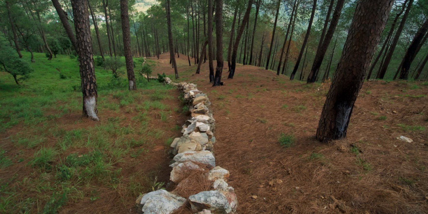
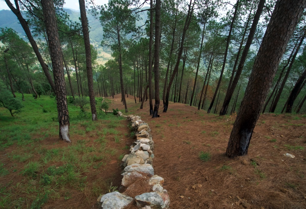
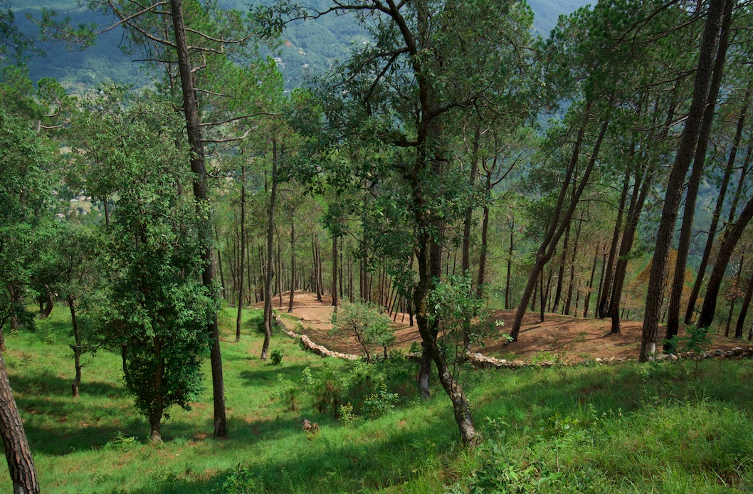
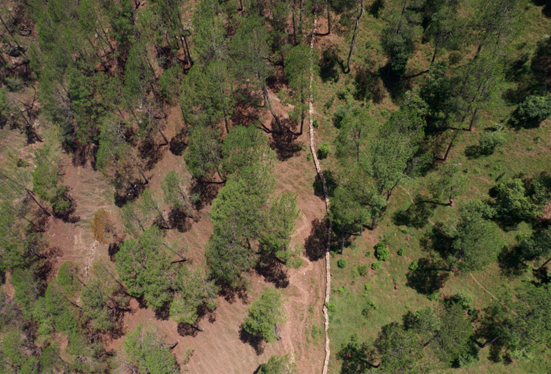
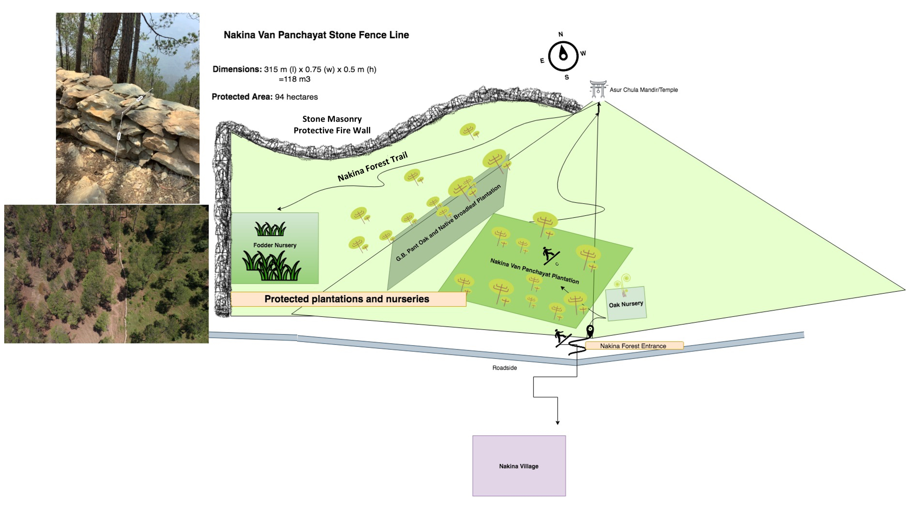
A rubble stone wall demarcates the community forest of Nakina Village and acts as a protective barrier against wildfire, wildlife, grazing, and human encroachment. The stone wall fencing is complemented by a firebreak, which is a gap of 2 meters. Firebreak establishment requires the removal of pine needles and debris from the border of the wall, so as to reduce the fuel load and possibility of fire spreading to the community forest.
2.2 การอธิบายแบบละเอียดของเทคโนโลยี
คำอธิบาย:
1. The technology has applied in the natural environment (Nakina Van Panchayat)
2. Characteristics of the technology:-
It is a dry stone wall in the community forest.
The wall (3.15km, 1m height, 80 cm width) is 40 years old and is being regularly maintained. The community is currently extending it to 4km.
3. Purpose and function of the technology:-
To protect the forest from forest fires.
To protect the fodder grasses from grazing animals
To protect the community forest from encroachment
To make a margin between two community forests.
4. Major activities and inputs needed to establish and maintain the technology:
Obtaining funding and external support to make the stone wall from other agencies (JICA, Forest Department)
The Forest department and Nakina Van Panchayat were the implementing agencies, and received approval from the District Magistrate to build the wall.
Nakina Van Panchayat organized the community people to construct the wall, paying each person 400 INR ($5.20 USD) a day for their work.
The community pooled their own construction materials and rocks were gathered on site.
5. Benefits and impacts of the Technology:
-Helps to protect forest fires from spreading to the Nakina community forest (physical barrier)
-Protect the fodder grasses from grazing animals
-Avoid conflict between two community forests and deter outsiders from crossing the wall
6. Impacts of the technology:
The wall is successful in protecting the forest from wildfire and it inhibits wildlife/livestock movements or passage.
The people of Nakina village are restricted to a particular area to collect fodder and forest products, which helps them regulate and realize their specific resource demands. This helps them avoid overexploitation of forest resources and set limits.
People views about the technology:-
Like: People are very positive about this technology and they believe that extending its length from 3.15km to 4km will further benefit the forest.
Dislike: The aesthetic of the forest is slightly compromised due to the construction wall.
During construction period, the people realized that some noise pollution from breaking stones could have disturbed neighbors grazing their livestock or other wildlife
2.3 รูปภาพของเทคโนโลยี
อัลบั้มสื่อบันทึก
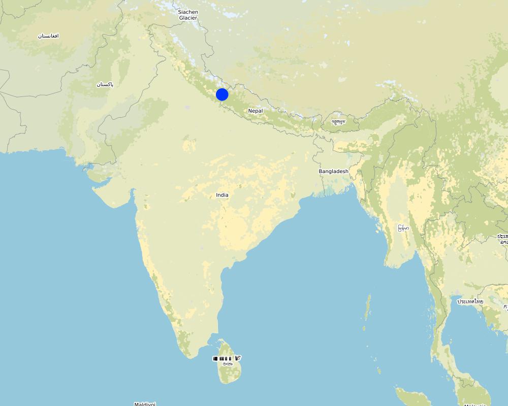
2.5 ประเทศภูมิภาค หรือสถานที่ตั้งที่เทคโนโลยีได้นำไปใช้และได้รับการครอบคลุมโดยการประเมินนี้
ประเทศ:
อินเดีย
ภูมิภาค/รัฐ/จังหวัด:
Uttarakhand
ข้อมูลจำเพาะเพิ่มเติมของสถานที่ตั้ง :
Naikina Village, Pithoragarh Bloc
ระบุการกระจายตัวของเทคโนโลยี:
- กระจายไปอย่างสม่ำเสมอในพื้นที่
If precise area is not known, indicate approximate area covered:
- 0.1-1 ตร.กม.
Is/are the technology site(s) located in a permanently protected area?
ใช่
ถ้าใช่ ระบุ:
The Nakina Van Panchayat protects 94 hectares of community forest.
Map
×2.6 วันที่การดำเนินการ
ถ้าไม่รู้ปีที่แน่นอน ให้ระบุวันที่โดยประมาณ:
- 10-50 ปี
2.7 คำแนะนำของเทคโนโลยี
ให้ระบุว่าเทคโนโลยีถูกแนะนำเข้ามาอย่างไร:
- เป็นส่วนหนึ่งของระบบแบบดั้งเดิมที่ทำก้นอยู่ (> 50 ปี)
ความคิดเห็น (ประเภทของโครงการ เป็นต้น) :
The wall is about 40 years old. It is common to separate community forests through stone fencing in well-managed Van Panchayat administrations. A stonewall fence is the ideal choice in hilly areas where stones are generally available and local people are able to make it themselves.
3. การจัดประเภทของเทคโนโลยี SLM
3.1 วัตถุประสงค์หลักของเทคโนโลยี
- ปรับปรุงการผลิตให้ดีขึ้น
- ลด ป้องกัน ฟื้นฟู การเสื่อมโทรมของที่ดิน
- อนุรักษ์ระบบนิเวศน์
- ป้องกันพื้นที่ลุ่มน้ำ/บริเวณท้ายน้ำ โดยร่วมกับเทคโนโลยีอื่นๆ
- ลดความเสี่ยงของภัยพิบัติ
3.2 ประเภทของการใช้ที่ดินในปัจจุบันที่ได้นำเทคโนโลยีไปใช้
Land use mixed within the same land unit:
ใช่
Specify mixed land use (crops/ grazing/ trees):
- ปศุสัตว์ร่วมกับการทำป่าไม้ (Silvo-pastoralism)

ทุ่งหญ้าเลี้ยงสัตว์
ทุ่งหญ้าเลี้ยงสัตว์ที่มีการจัดการแบบเข้มข้นหรือการผลิตอาหารสัตว์:
- ตัดแล้วขนไป / ไม่มีการปล่อยแทะเล็มเอง (Cut-and-carry / zero grazing)
Animal type:
- cattle - dairy
- goats
Is integrated crop-livestock management practiced?
ใช่
ถ้าใช่ ระบุ:
Manure is left or manually applied to enhance nutrient cycling of the soil and support fodder and tree growth.
ผลิตภัณฑ์และบริการ:
- meat
- milk
Species:
cattle - dairy
Species:
goats

ป่า/พื้นที่ทำไม้
- ป่า/พื้นที่ทำไม้
Tree plantation, afforestation: Specify origin and composition of species:
- การปลูกพืชพันธุ์ท้องถิ่นชนิดเดียว
Type of tree plantation, afforestation:
- subtropical dry forest plantation - Broadleaf
- quercus leucotrichophora, quercus glauca
Are the trees specified above deciduous or evergreen?
- deciduous
ผลิตภัณฑ์และบริการ:
- ไม้ซุง
- ไม้ที่นำมาทำเป็นเชื้อเพลิง
- การแทะเล็มหญ้า / การเก็บกินหญ้า
3.3 Has land use changed due to the implementation of the Technology?
Has land use changed due to the implementation of the Technology?
- Yes (Please fill out the questions below with regard to the land use before implementation of the Technology)
Land use mixed within the same land unit:
ใช่
Specify mixed land use (crops/ grazing/ trees):
- ปศุสัตว์ร่วมกับการทำป่าไม้ (Silvo-pastoralism)
ทุ่งหญ้าเลี้ยงสัตว์
Extensive grazing:
- กึ่งโนแมนดิซึ่มหรือแพสโตแรลลิซึ่ม (Semi-nomadism/pastoralism)
Animal type:
- cattle - dairy
- cattle - non-dairy working
- goats
Is integrated crop-livestock management practiced?
ใช่
ถ้าใช่ ระบุ:
Manure is left or manually applied to enhance nutrient cycling of the soil and support fodder and tree growth.
ผลิตภัณฑ์และบริการ:
- meat
- milk
Species:
cattle - dairy
Species:
goats
ป่า/พื้นที่ทำไม้
- ป่า/พื้นที่ทำไม้
Tree plantation, afforestation: Specify origin and composition of species:
- การปลูกพืชพันธุ์ท้องถิ่นชนิดเดียว
Type of tree plantation, afforestation:
- subtropical dry forest plantation - Broadleaf
- quercus leucotrichophora, quercus glauca
Are the trees specified above deciduous or evergreen?
- deciduous
ผลิตภัณฑ์และบริการ:
- ไม้ซุง
- ไม้ที่นำมาทำเป็นเชื้อเพลิง
- การแทะเล็มหญ้า / การเก็บกินหญ้า
แสดงความคิดเห็น:
Before the Van Panchayat was established (1952), there was grazing in the forest. Additionally, before the wall was constructed (1979), there was encroachment of livestock belonging to other villagers in the Nakina forest.
3.4 การใช้น้ำ
การใช้น้ำของที่ดินที่มีการใช้เทคโนโลยีอยู่:
- จากน้ำฝน
3.5 กลุ่ม SLM ที่ตรงกับเทคโนโลยีนี้
- การจัดการป่าธรรมชาติและกึ่งธรรมชาติ
3.6 มาตรการ SLM ที่ประกอบกันเป็นเทคโนโลยี

มาตรการอนุรักษ์ด้วยโครงสร้าง
- S6: กำแพง สิ่งกีดขวาง รั้วไม้ รั้วต่างๆ

มาตรการอนุรักษ์ด้วยการจัดการ
- M1: การเปลี่ยนรูปแบบของการใช้ประโยชน์ที่ดิน
- M2: การเปลี่ยนแปลงของการจัดการหรือระดับความเข้มข้น
3.7 รูปแบบหลักของการเสื่อมโทรมของที่ดินที่ได้รับการแก้ไขโดยเทคโนโลยี

การกัดกร่อนของดินโดยน้ำ
- Wt (Loss of topsoil): การสูญเสียดินชั้นบนหรือการกัดกร่อนที่ผิวดิน
- Wg (Gully erosion): การกัดกร่อนแบบร่องธารหรือการทำให้เกิดร่องน้ำเซาะ
- Wm (Mass movement): การเคลื่อนตัวของมวลดินหรือดินถล่ม

การเสื่อมโทรมของดินทางด้านชีวภาพ
- Bc (Reduction of vegetation cover): การลดลงของจำนวนพืชที่ปกคลุมดิน
- Bh (Loss of habitat): การสูญเสียแหล่งที่อยู่
- Bq (Quantity/biomass decline): การลดลงของปริมาณหรือมวลชีวภาพ
- Bf (Detrimenta leffects of fires): ผลเสียหายจากไฟ
- Bs (Quality and species composition): องค์ประกอบหรือความหลากหลายทางคุณภาพและชนิดพันธุ์ลดลง
- Bl (Loss of soil life): การสูญเสียสิ่งมีชีวิตในดิน
แสดงความคิดเห็น:
Soil erosion by water: The wall supports the forest and protected, diverse understory. Thereby, it supports infiltration, decreases runoff and its corresponding damages.
3.8 การป้องกัน การลดลง หรือการฟื้นฟูความเสื่อมโทรมของที่ดิน
ระบุเป้าหมายของเทคโนโลยีกับความเสื่อมโทรมของที่ดิน:
- ป้องกันความเสื่อมโทรมของที่ดิน
- ลดความเสื่อมโทรมของดิน
4. ข้อมูลจำเพาะด้านเทคนิค กิจกรรมการนำไปปฏิบัติใช้ ปัจจัยนำเข้า และค่าใช้จ่าย
4.1 แบบแปลนทางเทคนิคของเทคโนโลยี
ข้อมูลจำเพาะด้านเทคนิค (แบบแปลนทางเทคนิคของเทคโนโลยี):
Length: 3.15 km
315 m (l) x 0.75 (w) x 0.5 m (h) = 118 m3
Firebreak: 2m of littler is cleared on each side of the wall (1x per year during the dry season, after pine needles drop in April/May)
ผู้เขียน:
Jaclyn Bandy
วันที่:
22/08/2019
4.2 ข้อมูลทั่วไปเกี่ยวกับการคำนวณปัจจัยนำเข้าและค่าใช้จ่าย
ให้ระบุว่าค่าใช้จ่ายและปัจจัยนำเข้าได้รับการคำนวณอย่างไร:
- ต่อหน่วยเทคโนโลยี
โปรดระบุหน่วย:
Protective stone wall
Specify dimensions of unit (if relevant):
3.15 km
อื่นๆ หรือสกุลเงินประจำชาติ (ระบุ):
INR
If relevant, indicate exchange rate from USD to local currency (e.g. 1 USD = 79.9 Brazilian Real): 1 USD =:
70.0
ระบุค่าเฉลี่ยของค่าจ้างในการจ้างแรงงานต่อวัน:
400 INR / person
4.3 กิจกรรมเพื่อการจัดตั้ง
| กิจกรรม | Timing (season) | |
|---|---|---|
| 1. | Agreement between Nakina Van Panchayat, JICA and Forest Department for project implementation | Winter |
| 2. | Wall Preparation: Site demarcation, clearing of brush, vegetation, collection of stones | Winter |
| 3. | Random rubble stones of all shapes and sizes are chiseled; inconvenient edges are chipped off | Winter |
| 4. | Stones are piled on top of one another without mortar, and laid in irregular horizontal courses. | Winter |
| 5. | Regular monitoring by administrative committee on the construction site | Year round |
| 6. | Clearing dry pine needles around the dry stone (2m on each side of the wall) annually in the dry season. | April/May |
4.4 ค่าใช้จ่ายของปัจจัยนำเข้าที่จำเป็นสำหรับการจัดตั้ง
| ปัจจัยนำเข้า | หน่วย | ปริมาณ | ค่าใช้จ่ายต่อหน่วย | ค่าใช้จ่ายทั้งหมดต่อปัจจัยนำเข้า | %ของค่าใช้จ่ายที่ก่อให้เกิดขึ้นโดยผู้ใช้ที่ดิน | |
|---|---|---|---|---|---|---|
| แรงงาน | Unskilled, semi-skilled work (community) | person/day | 4200.0 | 400.0 | 1680000.0 | 100.0 |
| แรงงาน | Skilled (technical experts, trained construction workers) | person/day | 50.0 | 2000.0 | 100000.0 | 100.0 |
| อุปกรณ์ | Pick | pieces | 15.0 | 300.0 | 4500.0 | 100.0 |
| อุปกรณ์ | shovel | pieces | 20.0 | 500.0 | 10000.0 | 100.0 |
| อุปกรณ์ | pharuwa (hoe) | pieces | 15.0 | 300.0 | 4500.0 | 100.0 |
| อุปกรณ์ | khanti (digging bar) | pieces | 10.0 | 1500.0 | 15000.0 | 100.0 |
| อุปกรณ์ | hammer (5kg) | pieces | 10.0 | 2000.0 | 20000.0 | 100.0 |
| อุปกรณ์ | chino (chisel) | pieces | 10.0 | 500.0 | 5000.0 | 100.0 |
| อุปกรณ์ | Khukuri (knife) | pieces | 10.0 | 250.0 | 2500.0 | 100.0 |
| อุปกรณ์ | Small hammer (0.5-1kg) | pieces | 15.0 | 300.0 | 4500.0 | 100.0 |
| ค่าใช้จ่ายทั้งหมดของการจัดตั้งเทคโนโลยี | 1846000.0 | |||||
| Total costs for establishment of the Technology in USD | 26371.43 | |||||
แสดงความคิดเห็น:
Calculation for Labor: 0.75m/person/day
Hired Labor/Day: 30 people
Total Wall Construction/Day: 22.5m/day
Time: 3.15 km (3,150m) / 22.5 = 140 days (~ 5month)
Unit = 4200 (140x 30 people)
4.5 การบำรุงรักษาสภาพหรือกิจกรรมที่เกิดขึ้นเป็นประจำ
| กิจกรรม | ช่วงระยะเวลา/ความถี่ | |
|---|---|---|
| 1. | Maintaining small damages to wall structure | Year-round |
| 2. | Emergency tending to large sites of damage | Monsoon |
| 3. | Frequent visitations during the dry season/fire season | Pre monsoon |
| 4. | Firebreak establishment: clearing of pine needs 2m on each side of the wall | Peak Dry season |
แสดงความคิดเห็น:
The local people establish a firebreak (2m pine needle/brush clearance) from both sides of the wall. The labor cost is taken up by the community, which is a voluntary action.
4.6 ค่าใช้จ่ายของปัจจัยนำเข้าและกิจกรรมที่เกิดขึ้นเป็นประจำที่ต้องการการบำรุงรักษา (ต่อปี)
| ปัจจัยนำเข้า | หน่วย | ปริมาณ | ค่าใช้จ่ายต่อหน่วย | ค่าใช้จ่ายทั้งหมดต่อปัจจัยนำเข้า | %ของค่าใช้จ่ายที่ก่อให้เกิดขึ้นโดยผู้ใช้ที่ดิน | |
|---|---|---|---|---|---|---|
| แรงงาน | Unskilled/semiskilled | person-days | 100.0 | 400.0 | 40000.0 | 100.0 |
| แรงงาน | Skilled | person-days | 10.0 | 2000.0 | 20000.0 | 100.0 |
| อุปกรณ์ | Picks | pieces | 10.0 | 300.0 | 3000.0 | 100.0 |
| อุปกรณ์ | Shovel | pieces | 10.0 | 500.0 | 5000.0 | 100.0 |
| อุปกรณ์ | pharuwa (hoe) | pieces | 7.0 | 300.0 | 2100.0 | 100.0 |
| อุปกรณ์ | khanti (digging bar) | pieces | 7.0 | 1500.0 | 10500.0 | 100.0 |
| อุปกรณ์ | hammer | pieces | 5.0 | 2000.0 | 10000.0 | 100.0 |
| อุปกรณ์ | chino (chisel) | pieces | 9.0 | 500.0 | 4500.0 | 100.0 |
| อุปกรณ์ | khukuri (knife) | pieces | 5.0 | 250.0 | 1250.0 | 100.0 |
| อุปกรณ์ | small hammer | pieces | 15.0 | 300.0 | 4500.0 | 100.0 |
| ค่าใช้จ่ายทั้งหมดของการบำรุงรักษาสภาพเทคโนโลยี | 100850.0 | |||||
| Total costs for maintenance of the Technology in USD | 1440.71 | |||||
ถ้าผู้ใช้ที่ดินรับภาระน้อยกว่า 100% ของค่าใช้จ่าย ให้ระบุว่าใครเป็นผู้รับผิดชอบส่วนที่เหลือ:
Uttarakhand Forest Department, JICA
แสดงความคิดเห็น:
The costs of extending the wall to 4km are included in the maintenance costs. "Unskilled laborers" or villagers are payed by the communal funds contributed to the Nakina Van Panchayat.
There is however some remaining financial support from JICA/Uttarakhand Forest Department to maintain the wall (e.g. money to cover the replacement of broken or stolen tools) and technical engineer who comes for periodic checks on the construction progress.
For the current wall extension, the land users are paid by the funds and colletive savings managed by the Nakina Van Panchayat.
4.7 ปัจจัยสำคัญที่สุดที่มีผลกระทบต่อค่าใช้จ่าย
ปัจจัยสำคัญที่สุดที่มีผลกระทบต่อค่าใช้จ่ายต่างๆ:
Labor availability, extent of structural damage to the wall
5. สิ่งแวดล้อมทางธรรมชาติและของมนุษย์
5.1 ภูมิอากาศ
ฝนประจำปี
- < 250 ม.ม.
- 251-500 ม.ม.
- 501-750 ม.ม.
- 751-1,000 ม.ม.
- 1,001-1,500 ม.ม.
- 1,501-2,000 ม.ม.
- 2,001-3,000 ม.ม.
- 3,001-4,000 ม.ม.
- > 4,000 ม.ม.
ระบุปริมาณน้ำฝนเฉลี่ยรายปี (ถ้ารู้) :หน่วย ม.ม.
1500.00
ข้อมูลจำเพาะ/ความคิดเห็นเรื่องปริมาณน้ำฝน:
Monsoon- mid-June to mid-September; July and August are the rainiest months and the temperature is warm and moist; between 70-85% of the annual precipitation occurs in the monsoon season
ระบุชื่อของสถานีตรวดวัดอากาศที่ใช้อ้างอิงคือ:
India Meteorological Department, Meteorological Centre Dehradun
เขตภูมิอากาศเกษตร
- กึ่งชุ่มชื้น
The overall climatic condition in the Pithoragarh district is governed by the southwest monsoon. It has a sub-tropical to temperate climate, with three pronounced seasons; summer, winter, and monsoon. The hilly terrain of the Himalayan region has snow cover and is cold during winter with snowfall normally occurring during the months of December to March.
Temperature- The temperature ranges from 0°C to 10°C in winter and from 8°C to 33°C in summer season. However, there is no meteorological observatory in the district. The account of the climate is based mainly on the records of the observations in the neighboring districts where similar meteorological conditions prevail. Variations in temperature are considerable from place to place and depend upon elevation as well as aspect. As the insolation is intense at high altitudes, in summer temperatures are considerably higher in the open than in the shade.
5.2 สภาพภูมิประเทศ
ค่าเฉลี่ยความลาดชัน:
- ราบเรียบ (0-2%)
- ลาดที่ไม่ชัน (3-5%)
- ปานกลาง (6-10%)
- เป็นลูกคลื่น (11-15%)
- เป็นเนิน (16-30%)
- ชัน (31-60%)
- ชันมาก (>60%)
ธรณีสัณฐาน:
- ที่ราบสูง/ที่ราบ
- สันเขา
- ไหล่เขา
- ไหล่เนินเขา
- ตีนเนิน
- หุบเขา
ระดับความสูง:
- 0-100 เมตร
- 101-500 เมตร
- 501-1,000 เมตร
- 1,001-1,500 เมตร
- 1,501-2,000 เมตร
- 2,001-2,500 เมตร
- 2,501-3,000 เมตร
- 3,001-4,000 เมตร
- > 4,000 เมตร
ให้ระบุถ้าเทคโนโลยีได้ถูกนำไปใช้:
- บริเวณแอ่งบนที่ราบ (concave situations)
ความคิดเห็นและข้อมูลจำเพาะเพิ่มเติมเรื่องสภาพภูมิประเทศ:
Average Altitude of evaluated sites: 1990m
Average Slope: 28%
5.3 ดิน
ค่าเฉลี่ยความลึกของดิน:
- ตื้นมาก (0-20 ซ.ม.)
- ตื้น (21-50 ซ.ม.)
- ลึกปานกลาง (51-80 ซ.ม.)
- ลึก (81-120 ซ.ม.)
- ลึกมาก (>120 ซ.ม.)
เนื้อดิน (ดินชั้นบน):
- หยาบ/เบา (ดินทราย)
- ปานกลาง (ดินร่วน ทรายแป้ง)
เนื้อดินล่าง (> 20 ซ.ม.ต่ำจากผิวดิน):
- ปานกลาง (ดินร่วน ทรายแป้ง)
อินทรียวัตถุในดิน:
- ปานกลาง (1-3%)
- ต่ำ (<1%)
(ถ้ามี) ให้แนบคำอธิบายเรื่องดินแบบเต็มหรือระบุข้อมูลที่มีอยู่ เช่น ชนิดของดิน ค่า pH ของดินหรือความเป็นกรดของดิน ความสามารถในการแลกเปลี่ยนประจุบวก ไนโตรเจน ความเค็ม เป็นต้น:
Mountain/hill soils are a collective name given to various types of soils found under the following conditions :
-under sub-tropical, temperate and sub-alpine conditions
-under various forest types
Characteristics: very thin, fertile, and may be less than a centimeter deep on steep slopes; they are mixed with pebbles, shingles (a mass of small rounded pebbles), and gravels; they have a low-medium water holding capacity. Angular and subangular fragments of parent rock may be found mixed with the lower layers of the mountain and hill soils.
Texture: varies from loamy to sandy loam.
Soil Reaction: ranges from acidic to neutral (pH 4.6 to 6.5)
Organic Matter content: 1-5%
Ferrugenous red roils are found in this district and are well developed over Himalayan rocks (quartzite, biotite schist, amphibolite schist). They are free of carbonates and deficient in nitrogen, humus and phosphorus, light textured, porous, and friable (brittle/crumbly). The soil depth ranges from about 10cm-75 cm. These soils may be grouped into two on basis of morphology
1. Red earths- loose, friable topsoil rich in secondary concretions (hard, compact mass of matter formed by the precipitation of mineral cement within the spaces between particles, and is found in sedimentary rock or soil)
2. Red loam- argillaceous soils having a blocky structure (argillaceous minerals may appear silvery upon optical reflection and are minerals containing substantial amounts of clay-like components, e.g. argillaceous limestones are limestones consisting predominantly of calcium carbonate, but including 10-40% of clay minerals)
Brown soil: is found particularly under dense broadleaved temperate and sub-alpine forests. There occurs a thick layer of humus on the forest floor (made of decomposed leaves, branches, twigs) and the topsoil is extremely rich in humus
Podsolic Soil: soil that has developed in humid/temperate conditions usually under coniferous forests (e.g. deodar, blue pine, fir, spruce) over quartzite, granites, schists and gneiss.
5.4 ความเป็นประโยชน์และคุณภาพของน้ำ
ระดับน้ำใต้ดิน:
5-50 เมตร
น้ำไหลบ่าที่ผิวดิน:
ปานกลาง
คุณภาพน้ำ (ที่ยังไม่ได้บำบัด):
เป็นน้ำเพื่อการดื่มที่ดี
Water quality refers to:
ground water
ความเค็มของน้ำเป็นปัญหาหรือไม่:
ไม่ใช่
กำลังเกิดน้ำท่วมในพื้นที่หรือไม่:
ไม่ใช่
ความคิดเห็นและข้อมูลจำเพาะเพิ่มเติมเรื่องคุณภาพและปริมาณน้ำ:
Quantity: Water crisis has been a perennial problem in both the rural and urban areas of the Pithoragarh district
There is scarcity of safe drinking water of the villages in the study area. Hand pumps are often not functioning, pipe-water schemes are unreliable and the spring discharges have reduced during the dry season. Hand-pumped water often has a high iron content and bitter taste. Poor quality of groundwater in some of the naulas is mainly due to misuse and/or disuse of the structures.
A block-district groundwater resource estimation could not be carried out as the area is hilly (with slope >20%) and in major part aquifers are small, isolated bodies, and groundwater abstraction is done mainly through hand pumps and springs with small discharges.
However, we collected some physicochemical parameters that indicate the water (sourced from springs) is of good quality:
Water Quality Parameters of Springs:
pH: 6.29-8.18
Temp: 19.0-23.5 ºC
Electrical Conductivity: 109-504 µmsiemens
Total Dissolved Solids: 75-385 ppm
Other Parameters (from springs of nearby district, Champawat)
Electrical Conductivity: 127-222 µmsiemens
pH: 7.69-8.24
Calcium: 16-36 mg/l
Magnesium: 4.9-7.3 mg/l
Bicarbonate: 61-134 mg/l
Chloride: 5.3- 8.9 mg/l
Total Hardness as CaCO3: 70-110 mg/l
Source: Government of India Ministry of Water Resources, Central Ground Water Board, 2009 Groundwater Brochure of Champawat District (2009)
5.5 ความหลากหลายทางชีวภาพ
ความหลากหลายทางชนิดพันธุ์:
- ปานกลาง
ความหลากหลายของแหล่งที่อยู่:
- ปานกลาง
ความคิดเห็นและข้อมูลจำเพาะเพิ่มเติมของความหลากหลายทางชีวภาพ:
Uttarakhand has more than 7000 species of medicinal plants and 500 species of fauna. Floral diversity contributes 31% of total floral density of India. Fauna contributes just 1.58% of the total faunal density of the country. There are 119 endemic species of flowering plants in the state that exhibited 2.35% endemism and 35 faunal endemic species. Because it lies at the juncture of India, Nepal and the Tibeten Autononmous region, there often cases of poaching and smuggling of wildlife contrabands, including bear bile, musk pods and leopard skins through the borders. Yarsa Gumba Ophiocordyceps sinensis, commonly known as Caterpillar Fungus, is also illegally traded transboundary in the region, together with various plant species. Due to anthropogenic impacts, changes is soil quality, and climatic elements, the biodiversity of our study site is not as high as in other areas of the Pithoragarh district.
Citation: Sundriyal, M. & Sharma, B. (2016). Status of Biodiversity in Central Himalaya, Applied Ecology and Environmental Sciences, 4( 2), 37-43.
5.6 ลักษณะของผู้ใช้ที่ดินที่นำเทคโนโลยีไปปฏิบัติใช้
อยู่กับที่หรือเร่ร่อน:
- อยู่กับที่
แนวทางการตลาดของระบบการผลิต:
- เพื่อการยังชีพ (หาเลี้ยงตนเอง)
- mixed (subsistence/ commercial)
รายได้ที่มาจากนอกฟาร์ม:
- 10-50% ของรายได้ทั้งหมด
ระดับของความมั่งคั่งโดยเปรียบเทียบ:
- จน
เป็นรายบุคคล/ครัวเรือน:
- กลุ่ม/ชุมชน
ระดับของการใช้เครื่องจักรกล:
- งานที่ใช้แรงกาย
เพศ:
- หญิง
- ชาย
อายุของผู้ใช้ที่ดิน:
- ผู้เยาว์
- วัยกลางคน
- ผู้สูงอายุ
ระบุลักษณะอื่นๆที่เกี่ยวข้องของผู้ใช้ที่ดิน:
With recent development in Pithoragarh, an influx of funds coming from outside sources has caused a decline in the importance of agriculture production, which in now marginalized, based on female labour, and mainly conducted for subsistence with little surplus to sell. High caste men do not work in cultivation at all, and male tasks such as ploughing are performed by the Scheduled Caste.
Although most women are still cultivating, their work has lost economic importance. For most families, the produce does not cover the needs of the household and surplus must be bought from the market. Many of the terraces that were formerly fruit orchards (mainly citrus) have been completely abandoned. Farming is less intensive and landholdings are small and fragmented. The main crops are wheat, millet, and pulses, but yields are low as the land is not irrigated. Less livestock (cows, goats, buffalo) is kept because of the labor involved. Very little capital is returned to farming. Crops produced for the markets in the plains are replacing traditional crops to sustain the household.
With exposure to the“Modern” lifestyle, new values have also been accepted. Two children are the norm (the ideal being one son and one daughter, but at least one son in a must). Although access to education is quite good, it does not seem to result in working careers for women.
5.7 Average area of land used by land users applying the Technology
- < 0.5 เฮกตาร์
- 0.5-1 เฮกตาร์
- 1-2 เฮกตาร์
- 2-5 เฮกตาร์
- 5-15 เฮกตาร์
- 15-50 เฮกตาร์
- 50-100 เฮกตาร์
- 100-500 เฮกตาร์
- 500-1,000 เฮกตาร์
- 1,000-10,000 เฮกตาร์
- >10,000 เฮกตาร์
พิจารณาว่าเป็นขนาดเล็ก กลาง หรือขนาดใหญ่ (ซึ่งอ้างอิงถึงบริบทระดับท้องถิ่น):
- ขนาดเล็ก
5.8 กรรมสิทธิ์ในที่ดิน สิทธิในการใช้ที่ดินและสิทธิในการใช้น้ำ
กรรมสิทธิ์ในที่ดิน:
- เป็นแบบชุมชนหรือหมู่บ้าน
สิทธิในการใช้ที่ดิน:
- เกี่ยวกับชุมชน (ถูกจัดระเบียบ)
สิทธิในการใช้น้ำ:
- เข้าถึงได้แบบเปิด (ไม่ได้จัดระเบียบ)
- เกี่ยวกับชุมชน (ถูกจัดระเบียบ)
Are land use rights based on a traditional legal system?
ใช่
ระบุ:
Under the Kumaun Panchayat forest rules of 1931 (amended in 1976): A Van Panchayat, (community forest council), can be formed out of non-private land within the settlement boundaries of a village. Accordingly, all villagers are members of the VP upon their approval by a Sub-Divisional Magistrate under the state Revenue Department. The members are collectively referred to as the general body, which selects the management committee members through a democratic process.
แสดงความคิดเห็น:
5-9 elected members assume control and regulation of forest resources. They additionally raise funds and mobilize the village to protect and support sustainable land use. Presently 12,089 Van Panchayats are entrusted with the management of over 5,449.64 km2 of forests.
5.9 การเข้าถึงบริการและโครงสร้างพื้นฐาน
สุขภาพ:
- จน
- ปานกลาง
- ดี
การศึกษา:
- จน
- ปานกลาง
- ดี
ความช่วยเหลือทางด้านเทคนิค:
- จน
- ปานกลาง
- ดี
การจ้างงาน (เช่น ภายนอกฟาร์ม):
- จน
- ปานกลาง
- ดี
ตลาด:
- จน
- ปานกลาง
- ดี
พลังงาน:
- จน
- ปานกลาง
- ดี
ถนนและการขนส่ง:
- จน
- ปานกลาง
- ดี
น้ำดื่มและการสุขาภิบาล:
- จน
- ปานกลาง
- ดี
บริการด้านการเงิน:
- จน
- ปานกลาง
- ดี
แสดงความคิดเห็น:
The situation of infrastructure is difficult and inconsistent in the hill regions because of the terrain. The major infrastructural issues are drinking water and irrigation facilities, electricity, transportation and communication facilities and social infrastructure (housing and education). As for financial services, only the State Bank of India (SBI) is active in the hill regions where it is trying to achieve the objective of 100% financial inclusion. Some villages mentioned buying into into agricultural insurance in the past, however this was a temporary enterprise and they were never compensated after extreme climatic events that occurred and damaged over 70% of their crop.
Though infrastructure and education has generally improved over the years, institutional and marketing networks in the region aimed at supporting hill-farmers are lacking.
6. ผลกระทบและสรุปคำบอกกล่าว
6.1 ผลกระทบในพื้นที่ดำเนินการ (On-site) จากการใช้เทคโนโลยี
ผลกระทบทางด้านเศรษฐกิจและสังคม
การผลิต
การผลิตพืชที่ใช้เลี้ยงปศุสัตว์
จำนวนก่อน SLM:
2 ton/hectare
หลังจาก SLM:
10 ton/hectare
คุณภาพพืชที่ใช้เลี้ยงปศุสัตว์
แสดงความคิดเห็น/ระบุ:
More broadleaf species
การผลิตไม้
แสดงความคิดเห็น/ระบุ:
Fuelwood from broadleaved species is more plentiful
คุณภาพป่า /พื้นที่ทำไม้
แสดงความคิดเห็น/ระบุ:
Less pine encroachment and fire damage, tree lopping for fodder decreased by 15%
การผลิตของจากป่าทุกชนิดยกเว้นไม้
แสดงความคิดเห็น/ระบุ:
Resin collection has increased, pines residing in the protected forest are not damaged by the fire
พื้นที่สำหรับการผลิต
แสดงความคิดเห็น/ระบุ:
Rehabilitated areas that had previously been barren or overgrazed
การจัดการที่ดิน
แสดงความคิดเห็น/ระบุ:
Less dispute over land resources with a clear demarcation
ความเป็นประโยชน์และคุณภาพของน้ำ
การมีน้ำไว้ให้ปศุสัตว์
รายได้และค่าใช้จ่าย
ค่าใช่จ่ายของปัจจัยการผลิตทางการเกษตร
แสดงความคิดเห็น/ระบุ:
Less damage to plantation and fodder grasses, improved survivability of saplings and decreased costs of supplementary fodder
ความเหลื่อมล้ำทางเศรษฐกิจ
แสดงความคิดเห็น/ระบุ:
Decreased fodder availability gap during dry season
ภาระงาน
แสดงความคิดเห็น/ระบุ:
Women have saved approximately 1-2 hours in fodder collection
ผลกระทบด้านสังคมวัฒนธรรมอื่น ๆ
ความมั่นคงด้านอาหาร / พึ่งตนเองได้
แสดงความคิดเห็น/ระบุ:
Milk production of the livestock has increased due to improved fodder availability/quality
การใช้ที่ดิน / สิทธิในการใช้น้ำ
โอกาสทางวัฒนธรรม
แสดงความคิดเห็น/ระบุ:
Improved forest quality and aesthetic of forest surrounding the temple
โอกาสทางด้านสันทนาการ
สถาบันของชุมชน
SLM หรือความรู้เรื่องความเสื่อมโทรมของที่ดิน
แสดงความคิดเห็น/ระบุ:
Increased attention to landscape features and execution of SLM interventions within the community and Van Panchayat
การบรรเทาความขัดแย้ง
สถานการณ์ของกลุ่มด้อยโอกาส ทางด้านสังคมและเศรษฐกิจ
ผลกระทบด้านนิเวศวิทยา
วัฐจักรน้ำหรือน้ำบ่า
ปริมาณน้ำ
แสดงความคิดเห็น/ระบุ:
Improved infiltration and soil WHC
การเก็บเกี่ยวหรือการกักเก็บน้ำ
น้ำไหลบ่าที่ผิวดิน
น้ำบาดาลหรือระดับน้ำในแอ่งน้ำบาดาล
การระเหย
ดิน
ความชื้นในดิน
สิ่งปกคลุมดิน
การสูญเสียดิน
การสะสมของดิน
การเกิดแผ่นแข็งที่ผิวดิน /การเกิดชั้นดาน
การอัดแน่นของดิน
การหมุนเวียนและการเติมของธาตุอาหาร
อินทรียวัตถุในดิน/ต่ำกว่าดินชั้น C
ความหลากหลายทางชีวภาพของพืชและสัตว์
การปกคลุมด้วยพืช
มวลชีวภาพ/เหนือดินชั้น C
ความหลากหลายทางชีวภาพของพืช
พืชพันธุ์ต่างถิ่นที่รุกล้ำเข้ามา
ชนิดพันธุ์ที่ให้ประโยชน์
ความหลากหลายของสัตว์
ลดความเสี่ยงของภัยพิบัติ
ดินถล่ม/ ซากต่าง ๆ ที่ถูกพัดพามา
ผลกระทบจากภัยแล้ง
ผลกระทบของพายุไซโคลน พายุฝน
ความเสี่ยงจากไฟ
ภูมิอากาศจุลภาค
6.2 ผลกระทบนอกพื้นที่ดำเนินการ (Off-site) จากการใช้เทคโนโลยี
น้ำที่ใช้ประโยชน์ได้
การไหลของน้ำคงที่และสม่ำเสมอในช่วงฤดูแล้ง
ความสามารถต้านทานการเปลี่ยนแปลง / ความสามารถในการคัดกรอง
Specify assessment of off-site impacts (measurements):
The discharge of the Bhind Naula, Hess Dhara, and Vaishnavi Naula in Nakina Village has improved with the help of this water and soil conserving technology.
6.3 การเผชิญและความตอบสนองของเทคโนโลยีต่อการเปลี่ยนแปลงสภาพภูมิอากาศที่ค่อยเป็นค่อยไป และสภาพรุนแรงของภูมิอากาศ / ภัยพิบัติ (ที่รับรู้ได้โดยผู้ใช้ที่ดิน)
การเปลี่ยนแปลงสภาพภูมิอากาศที่ค่อยเป็นค่อยไป
การเปลี่ยนแปลงสภาพภูมิอากาศที่ค่อยเป็นค่อยไป
| ฤดู | increase or decrease | เทคโนโลยีมีวิธีการรับมืออย่างไร | |
|---|---|---|---|
| อุณหภูมิประจำปี | เพิ่มขึ้น | ดีมาก | |
| การเปลี่ยนแปลงสภาพภูมิอากาศที่ค่อยเป็นค่อยไปอื่น ๆ | Rainfall intensity | เพิ่มขึ้น | ดี |
สภาพรุนแรงของภูมิอากาศ (ภัยพิบัติ)
ภัยพิบัติทางอุตุนิยมวิทยา
| เทคโนโลยีมีวิธีการรับมืออย่างไร | |
|---|---|
| พายุฝนฟ้าคะนองประจำท้องถิ่น | ดี |
| พายุลูกเห็บประจำท้องถิ่น | ปานกลาง |
ภัยพิบัติจากสภาพภูมิอากาศ
| เทคโนโลยีมีวิธีการรับมืออย่างไร | |
|---|---|
| ภัยจากฝนแล้ง | ดี |
| ไฟป่า | ดี |
ภัยพิบัติจากน้ำ
| เทคโนโลยีมีวิธีการรับมืออย่างไร | |
|---|---|
| น้ำท่วมฉับพลัน | ปานกลาง |
| ดินถล่ม | ไม่ค่อยดี |
แสดงความคิดเห็น:
Although the wall is structurally sound in most sections, the impact of landslides and flash floods is often too great and significant damage results on areas were the slope is steep.
6.4 การวิเคราะห์ค่าใช้จ่ายและผลประโยชน์ที่ได้รับ
ผลประโยชน์ที่ได้รับเปรียบเทียบกับค่าใช้จ่ายในการจัดตั้งเป็นอย่างไร (จากมุมมองของผู้ใช้ที่ดิน)
ผลตอบแทนระยะสั้น:
ด้านบวกเล็กน้อย
ผลตอบแทนระยะยาว:
ด้านบวก
ผลประโยชน์ที่ได้รับเปรียบเทียบกับค่าใช้จ่ายในการบำรุงรักษาหรือต้นทุนที่เกิดขึ้นซ้ำอีก เป็นอย่างไร (จากมุมมองของผู้ใช้ที่ดิน)
ผลตอบแทนระยะสั้น:
ด้านบวก
ผลตอบแทนระยะยาว:
ด้านบวก
แสดงความคิดเห็น:
The work load is quite high for establishment and maintenance of the wall, especially when there is significant damage. Although upkeep can be demanding, the community sees the benefit of their efforts. This is especially recognized when the wall is secure from all sides and the firebreak is established before the fire season begins.
6.5 การปรับตัวของเทคโนโลยี
- 1-10%
Of all those who have adopted the Technology, how many did so spontaneously, i.e. without receiving any material incentives/ payments?
- 0-10%
แสดงความคิดเห็น:
Building an extensive wall, providing necessary tools and giving compensation for the labor adds up to be an expensive endeavor. Though the community initiative to maintain the wall can be managed by the Van Panchayat, external funding is necessary for these villages in most cases.
6.6 การปรับตัว
เทคโนโลยีได้รับการปรับเปลี่ยนเมื่อเร็วๆนี้ เพื่อให้ปรับตัวเข้ากับสภาพที่กำลังเปลี่ยนแปลงหรือไม่:
ใช่
ถ้าตอบว่าใช่ ให้ระบุว่าเงื่อนไขการเปลี่ยนแปลงใดที่ถูกปรับตัว:
- การเปลี่ยนแปลงแบบค่อยเป็นค่อยไปและสภาพรุนแรงของภูมิอากาศ
ให้ระบุการปรับตัวของเทคโนโลยี (การออกแบบ วัสดุหรือชนิดพันธุ์ เป็นต้น):
The wall is being extended from 3.15 km long to 4 km. The reasoning behind this is that the community believes that it will help protect the forest at a greater scale from wildfire, as the frequency is increasing due to climate change, neglect of forest management and historical pine plantations.
6.7 จุดแข็ง / ข้อได้เปรียบ / โอกาสของเทคโนโลยี
| จุดแข็ง / ข้อได้เปรียบ / โอกาสในทัศนคติของผู้ใช้ที่ดิน |
|---|
| Provides protection of the forest from forest fires and livestock grazing |
| More fuelwood and fodder is made available through this protective border |
| Because of determent from grazing and other intruders (human/wildlife), saplings and grasses are protected. This has improved the health of the forest, increased groundwater availability and improved spring recharge due to slowing surface runoff and better infiltration rates within the forest. |
| จุดแข็ง / ข้อได้เปรียบ / โอกาสในทัศนคติของผู้รวบรวมหรือวิทยากรหลัก |
|---|
| In agreement with the landuser |
6.8 จุดอ่อน / ข้อเสียเปรียบ / ความเสี่ยงของเทคโนโลยีและวิธีการแก้ไข
| จุดอ่อน / ข้อเสียเปรียบ / ความเสี่ยงในทัศนคติของผู้ใช้ที่ดิน | มีวิธีการแก้ไขได้อย่างไร |
|---|---|
| Height of the wall can be too short to act as an effective barrier for intense forest fires. | The lack of height can compromised by clearing the pine needles and creating a firebreak on both sides of the wall one additional meter. Placement of vegetation where dryer areas exist (or near grassy meadows) may also act as an effective biological barrier against the fires. |
| Parts of the wall on steep slopes often get damaged or destroyed | Avoid building the wall on steep slopes. If there are vulnerable areas, other reinforcement or alternative building technique maybe necessary. For example, building with the incline of the slope into the mountain side, so that the wall acts as more of a retaining structure. |
| จุดอ่อน / ข้อเสียเปรียบ / ความเสี่ยงในทัศนคติของผู้รวบรวมหรือวิทยากรหลัก | มีวิธีการแก้ไขได้อย่างไร |
|---|---|
| The stone wall's function is only as good as its construction. Some parts of the wall appear to be built in a secure, durable manner whereas other parts could be easily perturbed by pressure or vibration. | Proper training on engineering a stable wall would benefit the technology and reduce maintenance. Perhaps an external technical person could supervise wall-restoration and make periodic checks. Emphasizing the importance of diligent work on construction can be encouraged and incentivized with a higher wage (e.g. 600 INR instead of 400). |
|
Stone walls have inherent weaknesses against the lateral forces of earthquake. Poorly constructed walls having inadequate interlocking between the inside and the outside faces begin to separate, resulting in to rapid weakening of the wall. |
Assure sure that the measures required to counter these weaknesses are taken during the construction so that in the event of a potentially destructive earthquake, the structure is able to withstand its impact without suffering much damage. It is best to build in areas that have firm soil or rock underneath the topsoil. Soft soils can amplify wall movement during an earthquake. |
7. การอ้างอิงและการเชื่อมต่อ
7.1 วิธีการและแหล่งข้อมูล
- ไปเยี่ยมชมภาคสนาม การสำรวจพื้นที่ภาคสนาม
Two separate field visits, about 5 workers constructing the wall
- การสัมภาษณ์กับผู้ใช้ที่ดิน
Onsite interview with Mr. Jagdamba Joshi
วันที่เก็บรวบรวมข้อมูล(ภาคสนาม) :
26/06/2019
7.2 การอ้างอิงถึงสิ่งตีพิมพ์
หัวข้อ, ผู้เขียน, ปี, หมายเลข ISBN:
A TUTORIAL: Improving the Seismic Performance of Stone Masonry Buildings, Jitendra Bothara, Svetlana Brzevm, 2011, ISBN: 978-1-932884-48-7
ชื่อเรื่อง ผู้เขียน ปี ISBN:
https://www.academia.edu/20998004/A_TUTORIAL_Improving_the_Seismic_Performance_of_Stone_Masonry_Buildings
7.3 Links to relevant online information
ชื่อเรื่องหรือคำอธิบาย:
Technical Guidelines & Information for Stone Construction In Uttarakhand
URL:
https://www.sheltercluster.org/sites/default/files/docs/disaster_management_and_mitigation_centeruttarakhand-technical_guidelines_information_for_stone_construction_in_uttarakhand_part_i.pdf
ชื่อเรื่องหรือคำอธิบาย:
Policy Brief: Spring Revival through Sustainable Land Management (SLM) in the Himalayan Foothills: Uttarakhand, North India. Author: Liniger HP, Bandy J, Year: 2020
URL:
https://www.wocat.net/en/projects-and-countries/projects/onsite-and-offsite-benefits-sustainable-land-management/india
ชื่อเรื่องหรือคำอธิบาย:
Video: SLM for Himalayan Spring Revival. Author: Liniger HP, Bandy J, Year: 2020
URL:
https://vimeo.com/429988881
ลิงก์และโมดูล
ขยายทั้งหมด ย่อทั้งหมดลิงก์
Community Forest Management in the Nakina Van Panchayat [อินเดีย]
Van Panchayats or village forest councils are a impressive example of grassroots community management of natural resources, where a specific administrative unit is locally elected by community members who are responsible for the management of activities related to the forest.
- ผู้รวบรวม: Jaclyn Bandy
โมดูล
ไม่มีโมดูล