Stone Wall Fencing and Firebreak for Forest Protection [Inde]
- Création :
- Mise à jour :
- Compilateur : Jaclyn Bandy
- Rédacteur : –
- Examinateur : Hanspeter Liniger
technologies_5201 - Inde
Voir les sections
Développer tout Réduire tout1. Informations générales
1.2 Coordonnées des personnes-ressources et des institutions impliquées dans l'évaluation et la documentation de la Technologie
Personne(s)-ressource(s) clé(s)
exploitant des terres:
Joshi Jagdamda
Sarpanch, Nakinia Van Panchayat (Forest Community Head)
Inde
Nom du projet qui a facilité la documentation/ l'évaluation de la Technologie (si pertinent)
Onsite and Offsite Benefits of SLMNom du ou des institutions qui ont facilité la documentation/ l'évaluation de la Technologie (si pertinent)
ICIMOD International Centre for Integrated Mountain Development (ICIMOD) - NépalNom du ou des institutions qui ont facilité la documentation/ l'évaluation de la Technologie (si pertinent)
G.B. Pant Institute of Himalayan Einvironment & Development (G.B. Pant Institute of Himalayan Einvironment & Development) - Inde1.3 Conditions relatives à l'utilisation par WOCAT des données documentées
Le compilateur et la(les) personne(s) ressource(s) acceptent les conditions relatives à l'utilisation par WOCAT des données documentées:
Oui
1.4 Déclaration sur la durabilité de la Technologie décrite
Est-ce que la Technologie décrite ici pose problème par rapport à la dégradation des terres, de telle sorte qu'elle ne peut pas être déclarée comme étant une technologie de gestion durable des terres?
Non
1.5 Référence au(x) Questionnaires sur les Approches de GDT (documentées au moyen de WOCAT)

Community Forest Management in the Nakina Van Panchayat [Inde]
Van Panchayats or village forest councils are a impressive example of grassroots community management of natural resources, where a specific administrative unit is locally elected by community members who are responsible for the management of activities related to the forest.
- Compilateur : Jaclyn Bandy
2. Description de la Technologie de GDT
2.1 Courte description de la Technologie
Définition de la Technologie:
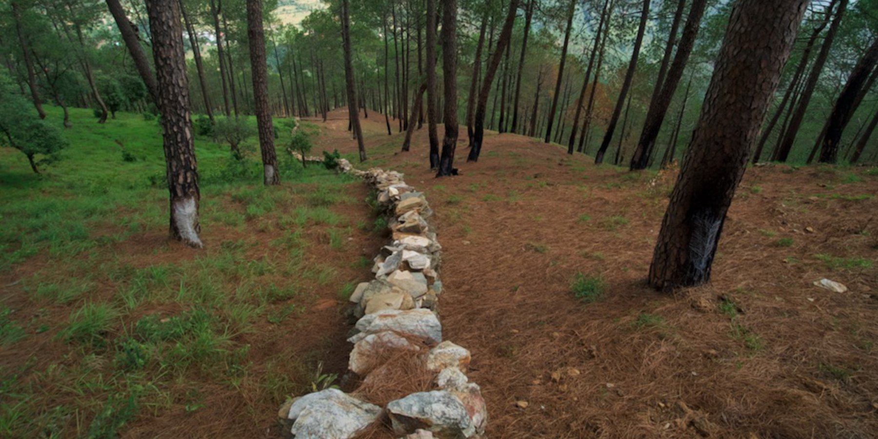
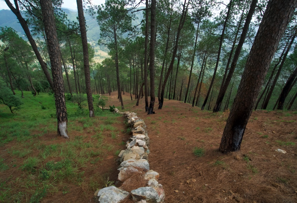
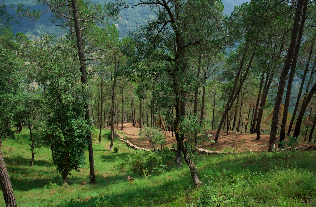
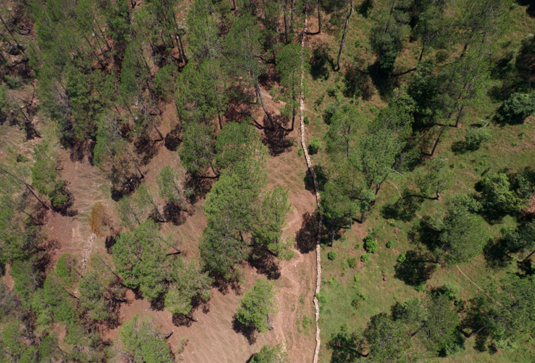
A rubble stone wall demarcates the community forest of Nakina Village and acts as a protective barrier against wildfire, wildlife, grazing, and human encroachment. The stone wall fencing is complemented by a firebreak, which is a gap of 2 meters. Firebreak establishment requires the removal of pine needles and debris from the border of the wall, so as to reduce the fuel load and possibility of fire spreading to the community forest.
2.2 Description détaillée de la Technologie
Description:
1. The technology has applied in the natural environment (Nakina Van Panchayat)
2. Characteristics of the technology:-
It is a dry stone wall in the community forest.
The wall (3.15km, 1m height, 80 cm width) is 40 years old and is being regularly maintained. The community is currently extending it to 4km.
3. Purpose and function of the technology:-
To protect the forest from forest fires.
To protect the fodder grasses from grazing animals
To protect the community forest from encroachment
To make a margin between two community forests.
4. Major activities and inputs needed to establish and maintain the technology:
Obtaining funding and external support to make the stone wall from other agencies (JICA, Forest Department)
The Forest department and Nakina Van Panchayat were the implementing agencies, and received approval from the District Magistrate to build the wall.
Nakina Van Panchayat organized the community people to construct the wall, paying each person 400 INR ($5.20 USD) a day for their work.
The community pooled their own construction materials and rocks were gathered on site.
5. Benefits and impacts of the Technology:
-Helps to protect forest fires from spreading to the Nakina community forest (physical barrier)
-Protect the fodder grasses from grazing animals
-Avoid conflict between two community forests and deter outsiders from crossing the wall
6. Impacts of the technology:
The wall is successful in protecting the forest from wildfire and it inhibits wildlife/livestock movements or passage.
The people of Nakina village are restricted to a particular area to collect fodder and forest products, which helps them regulate and realize their specific resource demands. This helps them avoid overexploitation of forest resources and set limits.
People views about the technology:-
Like: People are very positive about this technology and they believe that extending its length from 3.15km to 4km will further benefit the forest.
Dislike: The aesthetic of the forest is slightly compromised due to the construction wall.
During construction period, the people realized that some noise pollution from breaking stones could have disturbed neighbors grazing their livestock or other wildlife
2.3 Photos de la Technologie
Galerie Médias
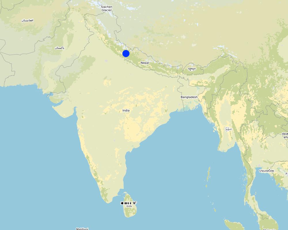
2.5 Pays/ région/ lieux où la Technologie a été appliquée et qui sont couverts par cette évaluation
Pays:
Inde
Région/ Etat/ Province:
Uttarakhand
Autres spécifications du lieu:
Naikina Village, Pithoragarh Bloc
Spécifiez la diffusion de la Technologie:
- répartie uniformément sur une zone
S'il n'existe pas d'informations exactes sur la superficie, indiquez les limites approximatives de la zone couverte:
- 0,1-1 km2
Est-ce que les sites dans lesquels la Technologie est appliquée sont situés dans des zones protégées en permanence?
Oui
Si oui, veuillez préciser:
The Nakina Van Panchayat protects 94 hectares of community forest.
Map
×2.6 Date de mise en œuvre de la Technologie
Si l'année précise est inconnue, indiquez la date approximative: :
- il y a entre 10-50 ans
2.7 Introduction de la Technologie
Spécifiez comment la Technologie a été introduite: :
- dans le cadre d'un système traditionnel (> 50 ans)
Commentaires (type de projet, etc.) :
The wall is about 40 years old. It is common to separate community forests through stone fencing in well-managed Van Panchayat administrations. A stonewall fence is the ideal choice in hilly areas where stones are generally available and local people are able to make it themselves.
3. Classification de la Technologie de GDT
3.1 Principal(aux) objectif(s) de la Technologie
- améliorer la production
- réduire, prévenir, restaurer les terres dégradées
- préserver l'écosystème
- protéger un bassin versant/ des zones situées en aval - en combinaison avec d'autres technologies
- réduire les risques de catastrophes
3.2 Type(s) actuel(s) d'utilisation des terres, là où la Technologie est appliquée
Les divers types d'utilisation des terres au sein du même unité de terrain: :
Oui
Précisez l'utilisation mixte des terres (cultures/ pâturages/ arbres):
- Sylvo-pastoralisme

Pâturages
Pâturage intensif/ production fourragère :
- Affouragement en vert/ zéro-pâturage
Type d'animal:
- bétail - laitier
- caprine
Est-ce que la gestion intégrée cultures-élevage est pratiquée?
Oui
Si oui, veuillez préciser:
Manure is left or manually applied to enhance nutrient cycling of the soil and support fodder and tree growth.
Produits et services:
- viande
- lait
Espèces:
bétail - laitier
Espèces:
caprine

Forêts/ bois
- Plantations d'arbres, boisements
Plantation d'arbres, afforestation: Précisez l'origine et la composition des espèces. :
- Variété locale en monoculture
Type de plantation d'arbres, d'afforestation:
- plantations de forêts sèches subtropicales - Forêts de feuillus
- quercus leucotrichophora, quercus glauca
Est-ce que les espèces d’arbres précisées ci-dessus sont des espèces d'arbre arbres à feuilles caduques ou à feuilles persistantes ?
- forêt de feuillus
Produits et services:
- Bois d'œuvre (de construction)
- Bois de chauffage
- Pâturage/ broutage
3.3 Est-ce que l’utilisation des terres a changé en raison de la mise en œuvre de la Technologie ?
Est-ce que l’utilisation des terres a changé en raison de la mise en œuvre de la Technologie ?
- Oui (Veuillez remplir les questions ci-après au regard de l’utilisation des terres avant la mise en œuvre de la Technologie)
Les divers types d'utilisation des terres au sein du même unité de terrain: :
Oui
Précisez l'utilisation mixte des terres (cultures/ pâturages/ arbres):
- Sylvo-pastoralisme
Pâturages
Pâturage extensif:
- Pastoralisme de type semi-nomade
Type d'animal:
- bétail - laitier
- bétail - non laitier, utilisé pour le travail
- caprine
Est-ce que la gestion intégrée cultures-élevage est pratiquée?
Oui
Si oui, veuillez préciser:
Manure is left or manually applied to enhance nutrient cycling of the soil and support fodder and tree growth.
Produits et services:
- viande
- lait
Espèces:
bétail - laitier
Espèces:
caprine
Forêts/ bois
- Plantations d'arbres, boisements
Plantation d'arbres, afforestation: Précisez l'origine et la composition des espèces. :
- Variété locale en monoculture
Type de plantation d'arbres, d'afforestation:
- plantations de forêts sèches subtropicales - Forêts de feuillus
- quercus leucotrichophora, quercus glauca
Est-ce que les espèces d’arbres précisées ci-dessus sont des espèces d'arbre arbres à feuilles caduques ou à feuilles persistantes ?
- forêt de feuillus
Produits et services:
- Bois d'œuvre (de construction)
- Bois de chauffage
- Pâturage/ broutage
Commentaires:
Before the Van Panchayat was established (1952), there was grazing in the forest. Additionally, before the wall was constructed (1979), there was encroachment of livestock belonging to other villagers in the Nakina forest.
3.4 Approvisionnement en eau
Approvisionnement en eau des terres sur lesquelles est appliquée la Technologie:
- pluvial
3.5 Groupe de GDT auquel appartient la Technologie
- gestion des forêts naturelles et semi-naturelles
3.6 Mesures de GDT constituant la Technologie

structures physiques
- S6: Murs, barrières, palissades, clôtures

modes de gestion
- M1: Changement du type d’utilisation des terres
- M2: Changement du niveau de gestion / d'intensification
3.7 Principaux types de dégradation des terres traités par la Technologie

érosion hydrique des sols
- Wt: perte de la couche superficielle des sols (couche arable)/ érosion de surface
- Wg: ravinement/ érosion en ravines
- Wm: mouvements de masse/ glissements de terrain

dégradation biologique
- Bc: réduction de la couverture végétale
- Bh: perte d’habitats
- Bq: baisse de la quantité/ biomasse
- Bf: effets néfastes des feux
- Bs: baisse de la qualité et de la composition/ diversité des espèces
- Bl: perte de la vie des sols
Commentaires:
Soil erosion by water: The wall supports the forest and protected, diverse understory. Thereby, it supports infiltration, decreases runoff and its corresponding damages.
3.8 Prévention, réduction de la dégradation ou réhabilitation des terres dégradées
Spécifiez l'objectif de la Technologie au regard de la dégradation des terres:
- prévenir la dégradation des terres
- réduire la dégradation des terres
4. Spécifications techniques, activités, intrants et coûts de mise en œuvre
4.1 Dessin technique de la Technologie
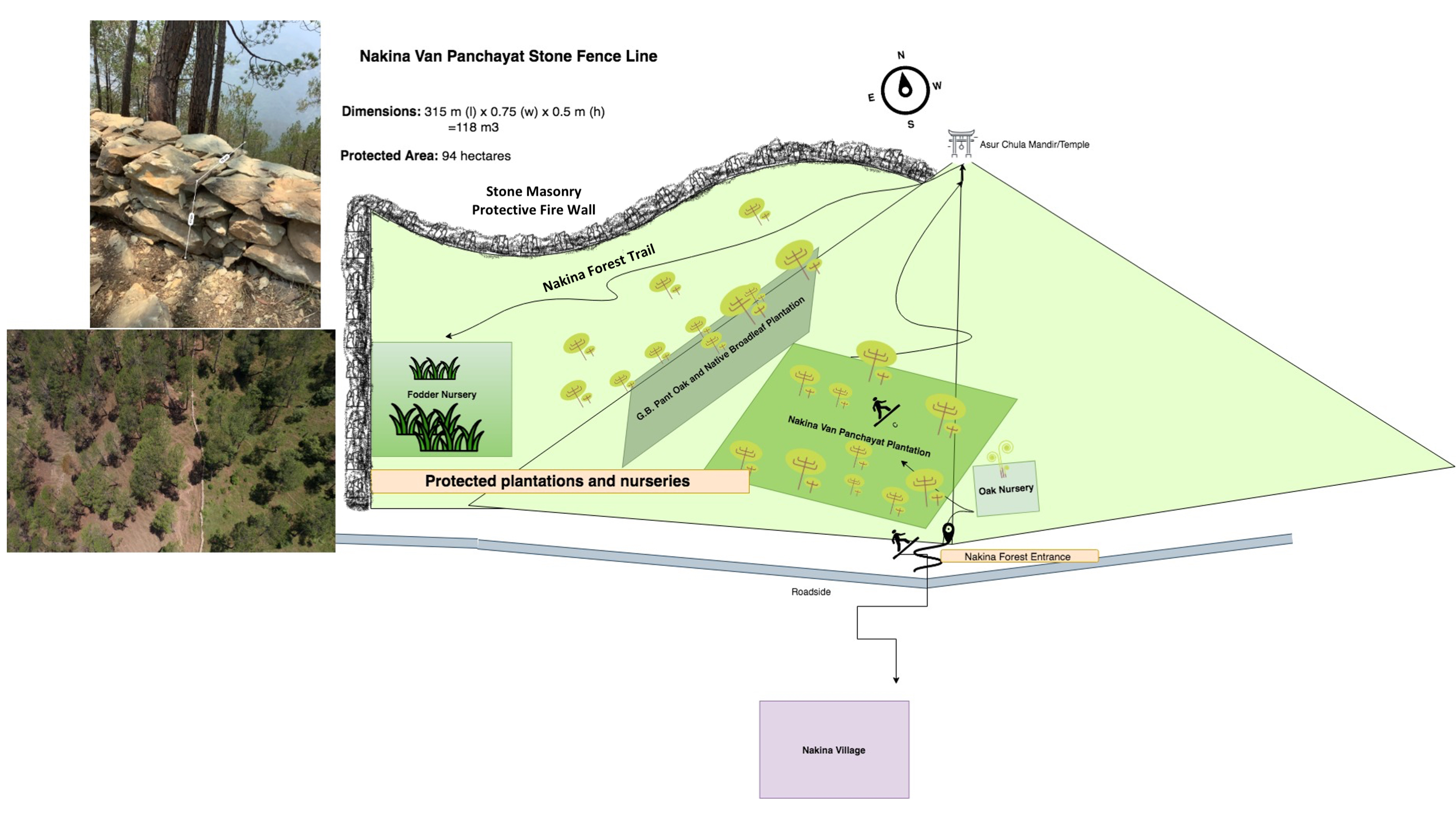
Spécifications techniques (associées au dessin technique):
Length: 3.15 km
315 m (l) x 0.75 (w) x 0.5 m (h) = 118 m3
Firebreak: 2m of littler is cleared on each side of the wall (1x per year during the dry season, after pine needles drop in April/May)
Auteur:
Jaclyn Bandy
Date:
22/08/2019
4.2 Informations générales sur le calcul des intrants et des coûts
Spécifiez la manière dont les coûts et les intrants ont été calculés:
- par entité de la Technologie
Précisez l'unité:
Protective stone wall
Précisez les dimensions de l'unité de terrain (le cas échéant):
3.15 km
autre/ monnaie nationale (précisez):
INR
Indiquez le taux de change des USD en devise locale, le cas échéant (p.ex. 1 USD = 79.9 réal brésilien): 1 USD = :
70,0
Indiquez le coût salarial moyen de la main d'œuvre par jour:
400 INR / person
4.3 Activités de mise en place/ d'établissement
| Activité | Calendrier des activités (saisonnier) | |
|---|---|---|
| 1. | Agreement between Nakina Van Panchayat, JICA and Forest Department for project implementation | Winter |
| 2. | Wall Preparation: Site demarcation, clearing of brush, vegetation, collection of stones | Winter |
| 3. | Random rubble stones of all shapes and sizes are chiseled; inconvenient edges are chipped off | Winter |
| 4. | Stones are piled on top of one another without mortar, and laid in irregular horizontal courses. | Winter |
| 5. | Regular monitoring by administrative committee on the construction site | Year round |
| 6. | Clearing dry pine needles around the dry stone (2m on each side of the wall) annually in the dry season. | April/May |
4.4 Coûts et intrants nécessaires à la mise en place
| Spécifiez les intrants | Unité | Quantité | Coûts par unité | Coût total par intrant | % du coût supporté par les exploitants des terres | |
|---|---|---|---|---|---|---|
| Main d'œuvre | Unskilled, semi-skilled work (community) | person/day | 4200,0 | 400,0 | 1680000,0 | 100,0 |
| Main d'œuvre | Skilled (technical experts, trained construction workers) | person/day | 50,0 | 2000,0 | 100000,0 | 100,0 |
| Equipements | Pick | pieces | 15,0 | 300,0 | 4500,0 | 100,0 |
| Equipements | shovel | pieces | 20,0 | 500,0 | 10000,0 | 100,0 |
| Equipements | pharuwa (hoe) | pieces | 15,0 | 300,0 | 4500,0 | 100,0 |
| Equipements | khanti (digging bar) | pieces | 10,0 | 1500,0 | 15000,0 | 100,0 |
| Equipements | hammer (5kg) | pieces | 10,0 | 2000,0 | 20000,0 | 100,0 |
| Equipements | chino (chisel) | pieces | 10,0 | 500,0 | 5000,0 | 100,0 |
| Equipements | Khukuri (knife) | pieces | 10,0 | 250,0 | 2500,0 | 100,0 |
| Equipements | Small hammer (0.5-1kg) | pieces | 15,0 | 300,0 | 4500,0 | 100,0 |
| Coût total de mise en place de la Technologie | 1846000,0 | |||||
| Coût total de mise en place de la Technologie en dollars américains (USD) | 26371,43 | |||||
Commentaires:
Calculation for Labor: 0.75m/person/day
Hired Labor/Day: 30 people
Total Wall Construction/Day: 22.5m/day
Time: 3.15 km (3,150m) / 22.5 = 140 days (~ 5month)
Unit = 4200 (140x 30 people)
4.5 Activités d'entretien/ récurrentes
| Activité | Calendrier/ fréquence | |
|---|---|---|
| 1. | Maintaining small damages to wall structure | Year-round |
| 2. | Emergency tending to large sites of damage | Monsoon |
| 3. | Frequent visitations during the dry season/fire season | Pre monsoon |
| 4. | Firebreak establishment: clearing of pine needs 2m on each side of the wall | Peak Dry season |
Commentaires:
The local people establish a firebreak (2m pine needle/brush clearance) from both sides of the wall. The labor cost is taken up by the community, which is a voluntary action.
4.6 Coûts et intrants nécessaires aux activités d'entretien/ récurrentes (par an)
| Spécifiez les intrants | Unité | Quantité | Coûts par unité | Coût total par intrant | % du coût supporté par les exploitants des terres | |
|---|---|---|---|---|---|---|
| Main d'œuvre | Unskilled/semiskilled | person-days | 100,0 | 400,0 | 40000,0 | 100,0 |
| Main d'œuvre | Skilled | person-days | 10,0 | 2000,0 | 20000,0 | 100,0 |
| Equipements | Picks | pieces | 10,0 | 300,0 | 3000,0 | 100,0 |
| Equipements | Shovel | pieces | 10,0 | 500,0 | 5000,0 | 100,0 |
| Equipements | pharuwa (hoe) | pieces | 7,0 | 300,0 | 2100,0 | 100,0 |
| Equipements | khanti (digging bar) | pieces | 7,0 | 1500,0 | 10500,0 | 100,0 |
| Equipements | hammer | pieces | 5,0 | 2000,0 | 10000,0 | 100,0 |
| Equipements | chino (chisel) | pieces | 9,0 | 500,0 | 4500,0 | 100,0 |
| Equipements | khukuri (knife) | pieces | 5,0 | 250,0 | 1250,0 | 100,0 |
| Equipements | small hammer | pieces | 15,0 | 300,0 | 4500,0 | 100,0 |
| Coût total d'entretien de la Technologie | 100850,0 | |||||
| Coût total d'entretien de la Technologie en dollars américains (USD) | 1440,71 | |||||
Si le coût n'est pas pris en charge à 100% par l'exploitant des terres, indiquez qui a financé le coût restant:
Uttarakhand Forest Department, JICA
Commentaires:
The costs of extending the wall to 4km are included in the maintenance costs. "Unskilled laborers" or villagers are payed by the communal funds contributed to the Nakina Van Panchayat.
There is however some remaining financial support from JICA/Uttarakhand Forest Department to maintain the wall (e.g. money to cover the replacement of broken or stolen tools) and technical engineer who comes for periodic checks on the construction progress.
For the current wall extension, the land users are paid by the funds and colletive savings managed by the Nakina Van Panchayat.
4.7 Facteurs les plus importants affectant les coûts
Décrivez les facteurs les plus importants affectant les coûts :
Labor availability, extent of structural damage to the wall
5. Environnement naturel et humain
5.1 Climat
Précipitations annuelles
- < 250 mm
- 251-500 mm
- 501-750 mm
- 751-1000 mm
- 1001-1500 mm
- 1501-2000 mm
- 2001-3000 mm
- 3001-4000 mm
- > 4000 mm
Spécifiez la pluviométrie moyenne annuelle (si connue), en mm:
1500,00
Spécifications/ commentaires sur les précipitations:
Monsoon- mid-June to mid-September; July and August are the rainiest months and the temperature is warm and moist; between 70-85% of the annual precipitation occurs in the monsoon season
Indiquez le nom de la station météorologique de référence considérée:
India Meteorological Department, Meteorological Centre Dehradun
Zone agro-climatique
- subhumide
The overall climatic condition in the Pithoragarh district is governed by the southwest monsoon. It has a sub-tropical to temperate climate, with three pronounced seasons; summer, winter, and monsoon. The hilly terrain of the Himalayan region has snow cover and is cold during winter with snowfall normally occurring during the months of December to March.
Temperature- The temperature ranges from 0°C to 10°C in winter and from 8°C to 33°C in summer season. However, there is no meteorological observatory in the district. The account of the climate is based mainly on the records of the observations in the neighboring districts where similar meteorological conditions prevail. Variations in temperature are considerable from place to place and depend upon elevation as well as aspect. As the insolation is intense at high altitudes, in summer temperatures are considerably higher in the open than in the shade.
5.2 Topographie
Pentes moyennes:
- plat (0-2 %)
- faible (3-5%)
- modéré (6-10%)
- onduleux (11-15%)
- vallonné (16-30%)
- raide (31-60%)
- très raide (>60%)
Reliefs:
- plateaux/ plaines
- crêtes
- flancs/ pentes de montagne
- flancs/ pentes de colline
- piémonts/ glacis (bas de pente)
- fonds de vallée/bas-fonds
Zones altitudinales:
- 0-100 m
- 101-500 m
- 501-1000 m
- 1001-1500 m
- 1501-2000 m
- 2001-2500 m
- 2501-3000 m
- 3001-4000 m
- > 4000 m
Indiquez si la Technologie est spécifiquement appliquée dans des:
- situations concaves
Commentaires et précisions supplémentaires sur la topographie:
Average Altitude of evaluated sites: 1990m
Average Slope: 28%
5.3 Sols
Profondeur moyenne du sol:
- très superficiel (0-20 cm)
- superficiel (21-50 cm)
- modérément profond (51-80 cm)
- profond (81-120 cm)
- très profond (>120 cm)
Texture du sol (de la couche arable):
- grossier/ léger (sablonneux)
- moyen (limoneux)
Texture du sol (> 20 cm sous la surface):
- moyen (limoneux)
Matière organique de la couche arable:
- moyen (1-3%)
- faible (<1%)
Si disponible, joignez une description complète du sol ou précisez les informations disponibles, par ex., type de sol, pH/ acidité du sol, capacité d'échange cationique, azote, salinité, etc.
Mountain/hill soils are a collective name given to various types of soils found under the following conditions :
-under sub-tropical, temperate and sub-alpine conditions
-under various forest types
Characteristics: very thin, fertile, and may be less than a centimeter deep on steep slopes; they are mixed with pebbles, shingles (a mass of small rounded pebbles), and gravels; they have a low-medium water holding capacity. Angular and subangular fragments of parent rock may be found mixed with the lower layers of the mountain and hill soils.
Texture: varies from loamy to sandy loam.
Soil Reaction: ranges from acidic to neutral (pH 4.6 to 6.5)
Organic Matter content: 1-5%
Ferrugenous red roils are found in this district and are well developed over Himalayan rocks (quartzite, biotite schist, amphibolite schist). They are free of carbonates and deficient in nitrogen, humus and phosphorus, light textured, porous, and friable (brittle/crumbly). The soil depth ranges from about 10cm-75 cm. These soils may be grouped into two on basis of morphology
1. Red earths- loose, friable topsoil rich in secondary concretions (hard, compact mass of matter formed by the precipitation of mineral cement within the spaces between particles, and is found in sedimentary rock or soil)
2. Red loam- argillaceous soils having a blocky structure (argillaceous minerals may appear silvery upon optical reflection and are minerals containing substantial amounts of clay-like components, e.g. argillaceous limestones are limestones consisting predominantly of calcium carbonate, but including 10-40% of clay minerals)
Brown soil: is found particularly under dense broadleaved temperate and sub-alpine forests. There occurs a thick layer of humus on the forest floor (made of decomposed leaves, branches, twigs) and the topsoil is extremely rich in humus
Podsolic Soil: soil that has developed in humid/temperate conditions usually under coniferous forests (e.g. deodar, blue pine, fir, spruce) over quartzite, granites, schists and gneiss.
5.4 Disponibilité et qualité de l'eau
Profondeur estimée de l’eau dans le sol:
5-50 m
Disponibilité de l’eau de surface:
moyenne
Qualité de l’eau (non traitée):
eau potable
La qualité de l'eau fait référence à:
eaux souterraines
La salinité de l'eau est-elle un problème? :
Non
La zone est-elle inondée?
Non
Commentaires et précisions supplémentaires sur la qualité et la quantité d'eau:
Quantity: Water crisis has been a perennial problem in both the rural and urban areas of the Pithoragarh district
There is scarcity of safe drinking water of the villages in the study area. Hand pumps are often not functioning, pipe-water schemes are unreliable and the spring discharges have reduced during the dry season. Hand-pumped water often has a high iron content and bitter taste. Poor quality of groundwater in some of the naulas is mainly due to misuse and/or disuse of the structures.
A block-district groundwater resource estimation could not be carried out as the area is hilly (with slope >20%) and in major part aquifers are small, isolated bodies, and groundwater abstraction is done mainly through hand pumps and springs with small discharges.
However, we collected some physicochemical parameters that indicate the water (sourced from springs) is of good quality:
Water Quality Parameters of Springs:
pH: 6.29-8.18
Temp: 19.0-23.5 ºC
Electrical Conductivity: 109-504 µmsiemens
Total Dissolved Solids: 75-385 ppm
Other Parameters (from springs of nearby district, Champawat)
Electrical Conductivity: 127-222 µmsiemens
pH: 7.69-8.24
Calcium: 16-36 mg/l
Magnesium: 4.9-7.3 mg/l
Bicarbonate: 61-134 mg/l
Chloride: 5.3- 8.9 mg/l
Total Hardness as CaCO3: 70-110 mg/l
Source: Government of India Ministry of Water Resources, Central Ground Water Board, 2009 Groundwater Brochure of Champawat District (2009)
5.5 Biodiversité
Diversité des espèces:
- moyenne
Diversité des habitats:
- moyenne
Commentaires et précisions supplémentaires sur la biodiversité:
Uttarakhand has more than 7000 species of medicinal plants and 500 species of fauna. Floral diversity contributes 31% of total floral density of India. Fauna contributes just 1.58% of the total faunal density of the country. There are 119 endemic species of flowering plants in the state that exhibited 2.35% endemism and 35 faunal endemic species. Because it lies at the juncture of India, Nepal and the Tibeten Autononmous region, there often cases of poaching and smuggling of wildlife contrabands, including bear bile, musk pods and leopard skins through the borders. Yarsa Gumba Ophiocordyceps sinensis, commonly known as Caterpillar Fungus, is also illegally traded transboundary in the region, together with various plant species. Due to anthropogenic impacts, changes is soil quality, and climatic elements, the biodiversity of our study site is not as high as in other areas of the Pithoragarh district.
Citation: Sundriyal, M. & Sharma, B. (2016). Status of Biodiversity in Central Himalaya, Applied Ecology and Environmental Sciences, 4( 2), 37-43.
5.6 Caractéristiques des exploitants des terres appliquant la Technologie
Sédentaire ou nomade:
- Sédentaire
Orientation du système de production:
- subsistance (auto-approvisionnement)
- exploitation mixte (de subsistance/ commerciale)
Revenus hors exploitation:
- 10-50% de tous les revenus
Niveau relatif de richesse:
- pauvre
Individus ou groupes:
- groupe/ communauté
Niveau de mécanisation:
- travail manuel
Genre:
- femmes
- hommes
Age des exploitants des terres:
- jeunes
- personnes d'âge moyen
- personnes âgées
Indiquez toute autre caractéristique pertinente des exploitants des terres:
With recent development in Pithoragarh, an influx of funds coming from outside sources has caused a decline in the importance of agriculture production, which in now marginalized, based on female labour, and mainly conducted for subsistence with little surplus to sell. High caste men do not work in cultivation at all, and male tasks such as ploughing are performed by the Scheduled Caste.
Although most women are still cultivating, their work has lost economic importance. For most families, the produce does not cover the needs of the household and surplus must be bought from the market. Many of the terraces that were formerly fruit orchards (mainly citrus) have been completely abandoned. Farming is less intensive and landholdings are small and fragmented. The main crops are wheat, millet, and pulses, but yields are low as the land is not irrigated. Less livestock (cows, goats, buffalo) is kept because of the labor involved. Very little capital is returned to farming. Crops produced for the markets in the plains are replacing traditional crops to sustain the household.
With exposure to the“Modern” lifestyle, new values have also been accepted. Two children are the norm (the ideal being one son and one daughter, but at least one son in a must). Although access to education is quite good, it does not seem to result in working careers for women.
5.7 Superficie moyenne des terres utilisées par les exploitants des terres appliquant la Technologie
- < 0,5 ha
- 0,5-1 ha
- 1-2 ha
- 2-5 ha
- 5-15 ha
- 15-50 ha
- 50-100 ha
- 100-500 ha
- 500-1 000 ha
- 1 000-10 000 ha
- > 10 000 ha
Cette superficie est-elle considérée comme de petite, moyenne ou grande dimension (en se référant au contexte local)?
- petite dimension
5.8 Propriété foncière, droits d’utilisation des terres et de l'eau
Propriété foncière:
- communauté/ village
Droits d’utilisation des terres:
- communautaire (organisé)
Droits d’utilisation de l’eau:
- accès libre (non organisé)
- communautaire (organisé)
Est-ce que les droits d'utilisation des terres sont fondés sur un système juridique traditionnel?
Oui
Précisez:
Under the Kumaun Panchayat forest rules of 1931 (amended in 1976): A Van Panchayat, (community forest council), can be formed out of non-private land within the settlement boundaries of a village. Accordingly, all villagers are members of the VP upon their approval by a Sub-Divisional Magistrate under the state Revenue Department. The members are collectively referred to as the general body, which selects the management committee members through a democratic process.
Commentaires:
5-9 elected members assume control and regulation of forest resources. They additionally raise funds and mobilize the village to protect and support sustainable land use. Presently 12,089 Van Panchayats are entrusted with the management of over 5,449.64 km2 of forests.
5.9 Accès aux services et aux infrastructures
santé:
- pauvre
- modéré
- bonne
éducation:
- pauvre
- modéré
- bonne
assistance technique:
- pauvre
- modéré
- bonne
emploi (par ex. hors exploitation):
- pauvre
- modéré
- bonne
marchés:
- pauvre
- modéré
- bonne
énergie:
- pauvre
- modéré
- bonne
routes et transports:
- pauvre
- modéré
- bonne
eau potable et assainissement:
- pauvre
- modéré
- bonne
services financiers:
- pauvre
- modéré
- bonne
Commentaires:
The situation of infrastructure is difficult and inconsistent in the hill regions because of the terrain. The major infrastructural issues are drinking water and irrigation facilities, electricity, transportation and communication facilities and social infrastructure (housing and education). As for financial services, only the State Bank of India (SBI) is active in the hill regions where it is trying to achieve the objective of 100% financial inclusion. Some villages mentioned buying into into agricultural insurance in the past, however this was a temporary enterprise and they were never compensated after extreme climatic events that occurred and damaged over 70% of their crop.
Though infrastructure and education has generally improved over the years, institutional and marketing networks in the region aimed at supporting hill-farmers are lacking.
6. Impacts et conclusions
6.1 Impacts sur site que la Technologie a montrés
Impacts socio-économiques
Production
production fourragère
Quantité avant la GDT:
2 ton/hectare
Quantité après la GDT:
10 ton/hectare
qualité des fourrages
Commentaires/ spécifiez:
More broadleaf species
production de bois
Commentaires/ spécifiez:
Fuelwood from broadleaved species is more plentiful
qualité des forêts/ bois
Commentaires/ spécifiez:
Less pine encroachment and fire damage, tree lopping for fodder decreased by 15%
production forestière non ligneuse
Commentaires/ spécifiez:
Resin collection has increased, pines residing in the protected forest are not damaged by the fire
surface de production
Commentaires/ spécifiez:
Rehabilitated areas that had previously been barren or overgrazed
gestion des terres
Commentaires/ spécifiez:
Less dispute over land resources with a clear demarcation
Disponibilité et qualité de l'eau
disponibilité de l'eau pour l'élevage
Revenus et coûts
dépenses pour les intrants agricoles
Commentaires/ spécifiez:
Less damage to plantation and fodder grasses, improved survivability of saplings and decreased costs of supplementary fodder
disparités économiques
Commentaires/ spécifiez:
Decreased fodder availability gap during dry season
charge de travail
Commentaires/ spécifiez:
Women have saved approximately 1-2 hours in fodder collection
Impacts socioculturels
sécurité alimentaire/ autosuffisance
Commentaires/ spécifiez:
Milk production of the livestock has increased due to improved fodder availability/quality
droits d'utilisation des terres/ de l'eau
opportunités culturelles
Commentaires/ spécifiez:
Improved forest quality and aesthetic of forest surrounding the temple
possibilités de loisirs
institutions communautaires
connaissances sur la GDT/ dégradation des terres
Commentaires/ spécifiez:
Increased attention to landscape features and execution of SLM interventions within the community and Van Panchayat
apaisement des conflits
situation des groupes socialement et économiquement désavantagés
Impacts écologiques
Cycle de l'eau/ ruissellement
quantité d'eau
Commentaires/ spécifiez:
Improved infiltration and soil WHC
récolte/ collecte de l'eau
ruissellement de surface
nappes phréatiques/ aquifères
évaporation
Sols
humidité du sol
couverture du sol
perte en sol
accumulation de sol
encroûtement/ battance du sol
compaction du sol
cycle/ recharge des éléments nutritifs
matière organique du sol/ au dessous du sol C
Biodiversité: végétale, animale
Couverture végétale
biomasse/ au dessus du sol C
diversité végétale
espèces étrangères envahissantes
espèces bénéfiques
diversité des habitats
Réduction des risques de catastrophe et des risques climatiques
glissements de terrains/coulées de débris
impacts de la sécheresse
impacts des cyclones, pluies torrentielles
risques d'incendies
microclimat
6.2 Impacts hors site que la Technologie a montrés
disponibilité de l'eau
flux des cours d'eau fiables et stables en saison sèche
capacité tampon/de filtration
Précisez l'évaluation des impacts extérieurs (sous forme de mesures):
The discharge of the Bhind Naula, Hess Dhara, and Vaishnavi Naula in Nakina Village has improved with the help of this water and soil conserving technology.
6.3 Exposition et sensibilité de la Technologie aux changements progressifs et aux évènements extrêmes/catastrophes liés au climat (telles que perçues par les exploitants des terres)
Changements climatiques progressifs
Changements climatiques progressifs
| Saison | Augmentation ou diminution | Comment la Technologie fait-elle face à cela? | |
|---|---|---|---|
| températures annuelles | augmente | très bien | |
| autre changement climatique progressif | Rainfall intensity | augmente | bien |
Extrêmes climatiques (catastrophes)
Catastrophes météorologiques
| Comment la Technologie fait-elle face à cela? | |
|---|---|
| orage local | bien |
| averse de grêle locale | modérément |
Catastrophes climatiques
| Comment la Technologie fait-elle face à cela? | |
|---|---|
| sécheresse | bien |
| feu de forêt | bien |
Catastrophes hydrologiques
| Comment la Technologie fait-elle face à cela? | |
|---|---|
| crue éclair | modérément |
| glissement de terrain | pas bien |
Commentaires:
Although the wall is structurally sound in most sections, the impact of landslides and flash floods is often too great and significant damage results on areas were the slope is steep.
6.4 Analyse coûts-bénéfices
Quels sont les bénéfices comparativement aux coûts de mise en place (du point de vue des exploitants des terres)?
Rentabilité à court terme:
légèrement positive
Rentabilité à long terme:
positive
Quels sont les bénéfices comparativement aux coûts d'entretien récurrents (du point de vue des exploitants des terres)?
Rentabilité à court terme:
positive
Rentabilité à long terme:
positive
Commentaires:
The work load is quite high for establishment and maintenance of the wall, especially when there is significant damage. Although upkeep can be demanding, the community sees the benefit of their efforts. This is especially recognized when the wall is secure from all sides and the firebreak is established before the fire season begins.
6.5 Adoption de la Technologie
- 1-10%
De tous ceux qui ont adopté la Technologie, combien d'entre eux l'ont fait spontanément, à savoir sans recevoir aucune incitation matérielle, ou aucune rémunération? :
- 0-10%
Commentaires:
Building an extensive wall, providing necessary tools and giving compensation for the labor adds up to be an expensive endeavor. Though the community initiative to maintain the wall can be managed by the Van Panchayat, external funding is necessary for these villages in most cases.
6.6 Adaptation
La Technologie a-t-elle été récemment modifiée pour s'adapter à l'évolution des conditions?
Oui
Si oui, indiquez à quel changement la Technologie s'est adaptée:
- changements/ extrêmes climatiques
Spécifiez l'adaptation de la Technologie (conception, matériaux/ espèces, etc.):
The wall is being extended from 3.15 km long to 4 km. The reasoning behind this is that the community believes that it will help protect the forest at a greater scale from wildfire, as the frequency is increasing due to climate change, neglect of forest management and historical pine plantations.
6.7 Points forts/ avantages/ possibilités de la Technologie
| Points forts/ avantages/ possibilités du point de vue de l'exploitant des terres |
|---|
| Provides protection of the forest from forest fires and livestock grazing |
| More fuelwood and fodder is made available through this protective border |
| Because of determent from grazing and other intruders (human/wildlife), saplings and grasses are protected. This has improved the health of the forest, increased groundwater availability and improved spring recharge due to slowing surface runoff and better infiltration rates within the forest. |
| Points forts/ avantages/ possibilités du point de vue du compilateur ou d'une autre personne ressource clé |
|---|
| In agreement with the landuser |
6.8 Faiblesses/ inconvénients/ risques de la Technologie et moyens de les surmonter
| Faiblesses/ inconvénients/ risques du point de vue de l’exploitant des terres | Comment peuvent-ils être surmontés? |
|---|---|
| Height of the wall can be too short to act as an effective barrier for intense forest fires. | The lack of height can compromised by clearing the pine needles and creating a firebreak on both sides of the wall one additional meter. Placement of vegetation where dryer areas exist (or near grassy meadows) may also act as an effective biological barrier against the fires. |
| Parts of the wall on steep slopes often get damaged or destroyed | Avoid building the wall on steep slopes. If there are vulnerable areas, other reinforcement or alternative building technique maybe necessary. For example, building with the incline of the slope into the mountain side, so that the wall acts as more of a retaining structure. |
| Faiblesses/ inconvénients/ risques du point de vue du compilateur ou d'une autre personne ressource clé | Comment peuvent-ils être surmontés? |
|---|---|
| The stone wall's function is only as good as its construction. Some parts of the wall appear to be built in a secure, durable manner whereas other parts could be easily perturbed by pressure or vibration. | Proper training on engineering a stable wall would benefit the technology and reduce maintenance. Perhaps an external technical person could supervise wall-restoration and make periodic checks. Emphasizing the importance of diligent work on construction can be encouraged and incentivized with a higher wage (e.g. 600 INR instead of 400). |
|
Stone walls have inherent weaknesses against the lateral forces of earthquake. Poorly constructed walls having inadequate interlocking between the inside and the outside faces begin to separate, resulting in to rapid weakening of the wall. |
Assure sure that the measures required to counter these weaknesses are taken during the construction so that in the event of a potentially destructive earthquake, the structure is able to withstand its impact without suffering much damage. It is best to build in areas that have firm soil or rock underneath the topsoil. Soft soils can amplify wall movement during an earthquake. |
7. Références et liens
7.1 Méthodes/ sources d'information
- visites de terrain, enquêtes sur le terrain
Two separate field visits, about 5 workers constructing the wall
- interviews/entretiens avec les exploitants des terres
Onsite interview with Mr. Jagdamba Joshi
Quand les données ont-elles été compilées (sur le terrain)?
26/06/2019
7.2 Références des publications disponibles
Titre, auteur, année, ISBN:
A TUTORIAL: Improving the Seismic Performance of Stone Masonry Buildings, Jitendra Bothara, Svetlana Brzevm, 2011, ISBN: 978-1-932884-48-7
Disponible à partir d'où? Coût?
https://www.academia.edu/20998004/A_TUTORIAL_Improving_the_Seismic_Performance_of_Stone_Masonry_Buildings
7.3 Liens vers les informations pertinentes en ligne
Titre/ description:
Technical Guidelines & Information for Stone Construction In Uttarakhand
URL:
https://www.sheltercluster.org/sites/default/files/docs/disaster_management_and_mitigation_centeruttarakhand-technical_guidelines_information_for_stone_construction_in_uttarakhand_part_i.pdf
Titre/ description:
Policy Brief: Spring Revival through Sustainable Land Management (SLM) in the Himalayan Foothills: Uttarakhand, North India. Author: Liniger HP, Bandy J, Year: 2020
URL:
https://www.wocat.net/en/projects-and-countries/projects/onsite-and-offsite-benefits-sustainable-land-management/india
Titre/ description:
Video: SLM for Himalayan Spring Revival. Author: Liniger HP, Bandy J, Year: 2020
URL:
https://vimeo.com/429988881
Liens et modules
Développer tout Réduire toutLiens
Community Forest Management in the Nakina Van Panchayat [Inde]
Van Panchayats or village forest councils are a impressive example of grassroots community management of natural resources, where a specific administrative unit is locally elected by community members who are responsible for the management of activities related to the forest.
- Compilateur : Jaclyn Bandy
Modules
Aucun module trouvé