On-farm ponds to alleviate the potential impact of seasonal droughts and for increasing crop cultivation and aquaculture [Cambodia]
- Creation:
- Update:
- Compiler: Nary Lay
- Editors: Navin Chea, Sophea Tim, Sok Pheak
- Reviewers: Nicole Harari, Nimul CHUN, Stephanie Jaquet
technologies_2844 - Cambodia
View sections
Expand all Collapse all1. General information
1.2 Contact details of resource persons and institutions involved in the assessment and documentation of the Technology
Key resource person(s)
land user:
Manh Hong
(+855) 71 677 2221
NA
Farmer
Srayang Cheung village, Srayang commune, Kuleaen district, Preah Vihear province.
Cambodia
CEW at Srayang Commune:
Kuch Vin
(+855) 97 284 14 44
NA
Commune Office
Srayang Cheung village, Srayang commune, Kuleaen district, Preah Vihear province
Cambodia
Chief of Kuleaen Agriculture, Forestry and Fishery district :
Director of Center Agricultural and Environmental for Studies, RUA:
Official of Choam Khsant Agriculture, Forestry and Fisheries District (Veterinary):
Name of project which facilitated the documentation/ evaluation of the Technology (if relevant)
Scaling-up SLM practices by smallholder farmers (IFAD)Name of the institution(s) which facilitated the documentation/ evaluation of the Technology (if relevant)
Royal University of Agriculture (RUA) - Cambodia1.3 Conditions regarding the use of data documented through WOCAT
The compiler and key resource person(s) accept the conditions regarding the use of data documented through WOCAT:
Yes
1.4 Declaration on sustainability of the described Technology
Is the Technology described here problematic with regard to land degradation, so that it cannot be declared a sustainable land management technology?
No
2. Description of the SLM Technology
2.1 Short description of the Technology
Definition of the Technology:
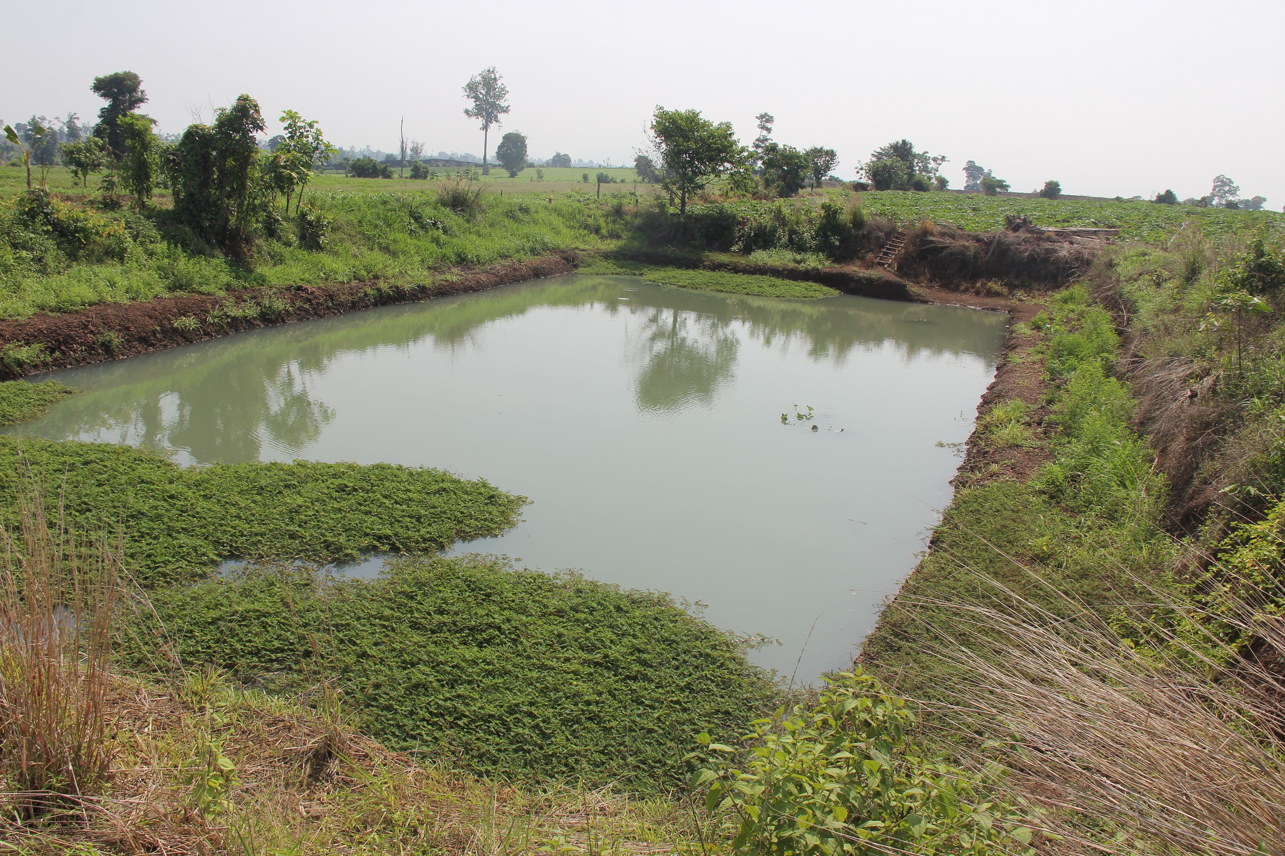
Digging ponds on farms to harvest rain water used for irrigating crops during drought provides a means for addressing a lack of water at the start of crop cultivation, both before the start of the rainy season and after the end of the rainy season. The main objective of this practice is to increase the duration of the potential growing seasons for crops. A pond with a storage capacity of 2,412 cubic meter of water can potentially irrigate crops year-round in an area of at least 1.6 hectares, including during the dry-season.
2.2 Detailed description of the Technology
Description:
In areas with low rainfall and limited or lack of irrigation systems, the harvesting of rainwater for potential irrigation is an important practice for crop cultivation and food security. The amount of water potentially available is also an integral factor that farmers need to take into account. Furthermore, climate change is another pressure for farmers to adapt to, due to the potential adverse impact on agricultural activities, including a reduction in crop yields, increases in the incidence of crop diseases and insect pests, together with more frequent extreme weather events, including irregular rainfall, droughts and floods.
In response to the above issues, farmers have the potential to dig ponds for water storage, and the application of drip irrigation for cropping activities. The development of on-farm ponds provides a crop water resource during drought periods, while also providing opportunities for small-scale aquaculture and vegetable cropping. Having a pond in a field is regarded as being resilient to climate change (climate-smart agriculture) because farmers can have sufficient water for irrigation in all seasons throughout the year.
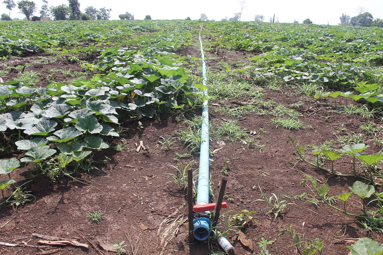
With the application of drip irrigation, farmers save water and time. Labour input for irrigation is reduced while a better environment is provided for crop growth, reduced soil erosion and better management of weeds, diseases and some insect pests. Drip irrigation is also a system of irrigation that maximizes water use efficiency in periods of drought in response to climate change.
Before making the decision to dig a pond, the farmer had observed and estimated the availability of water resources including the groundwater in the area for around two years by learning from the existing wells of neighbours around his land. The selected point for digging the pond is at the lowest part of his land, and it is also based on the fact he found that the neighbouring pump wells have good source of groundwater. This pond hence collects rainwater and connects to underground water aquifer, which is not very deep.
A farmer may not have to spend money for the digging of a pond on his land, as it is potentially possible to reach an agreement with the owner of an excavator (soil digging machine), to allow the owner of the machine to take the excavated soil in payment for the excavation of the pond. Without such a mutual agreement, the cost to the farmer of digging a pond could be as high as 8 million riel (about US$2,000). A suitable farm pond would need to have surface size of 40 x 20 meters and a bottom size of 29 x 14 meters. A pond depth of 4 meters might potentially provide 2 meters depth of water which can potentially provide sufficient water to irrigate over 1.6 hectares of crop in the dry-season, thereby enable farmers to grow at least two crops per year (or perhaps four crops that are short maturing). Farmers have also been able to raise at least 600 Tilapia fish (a freshwater fish) in the ponds.
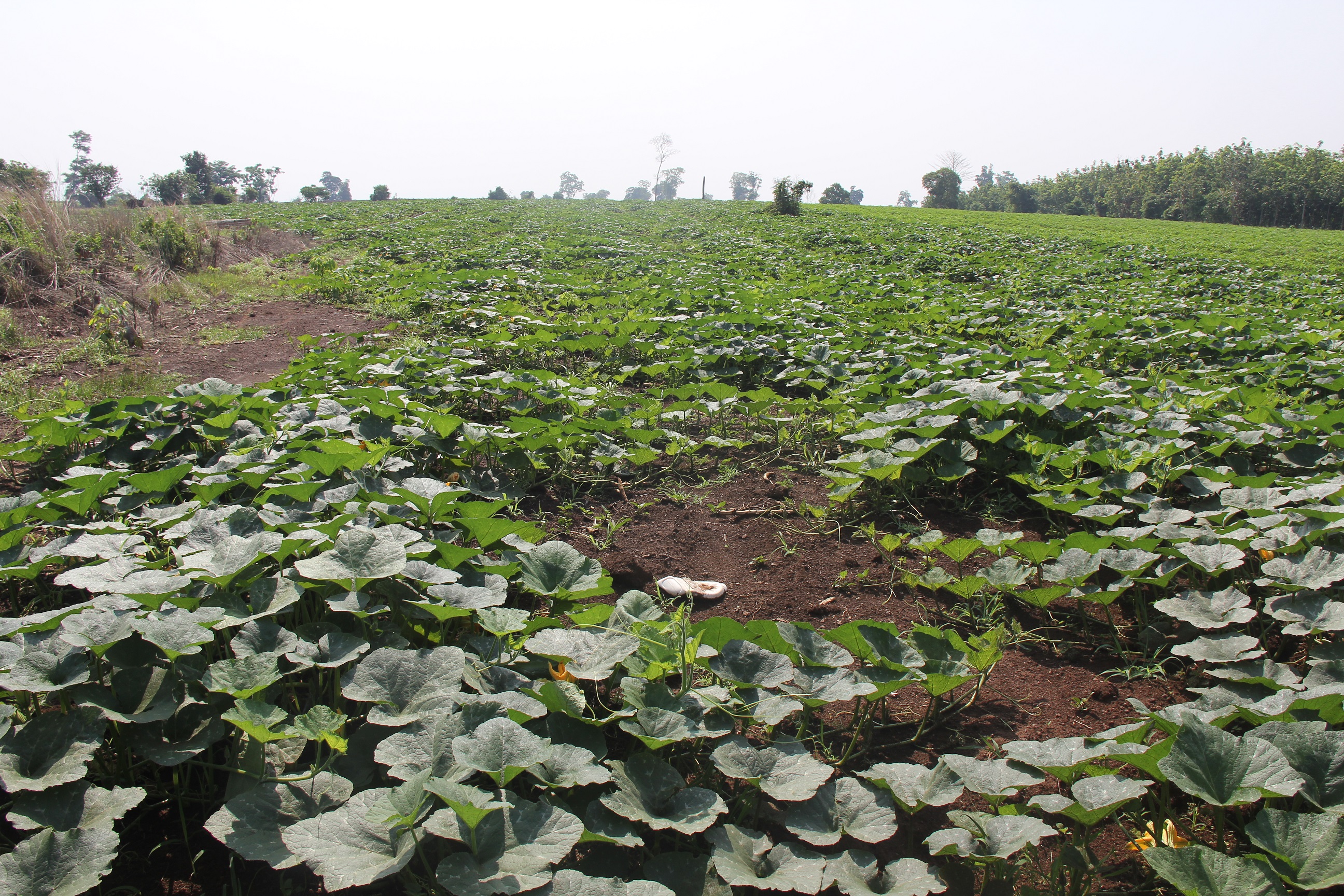
Farmers with access to water from a farm pond are able to grow more crops than previously, get higher yields, and grow crops such as pumpkin in the dry-season due to having access to water for irrigation.
2.3 Photos of the Technology
Media Gallery
2.5 Country/ region/ locations where the Technology has been applied and which are covered by this assessment
Country:
Cambodia
Region/ State/ Province:
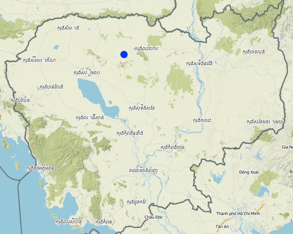
Srayang Tboung village, Srayang commune, Kuleaen district, Preah Vihear province
Comments:
At Srayang Tboung villge, Srayang commune, Kuleaen district, Preah Vihear province
Map
×2.6 Date of implementation
Indicate year of implementation:
2013
2.7 Introduction of the Technology
Specify how the Technology was introduced:
- through land users' innovation
Comments (type of project, etc.):
The farmer observed the availability of groundwater source with the existing wells of neighbours around his land, and digged the pond at the lowest point of his land to collect both rainwater and groundwater.
3. Classification of the SLM Technology
3.1 Main purpose(s) of the Technology
- improve production
- adapt to climate change/ extremes and its impacts
- create beneficial social impact
- Can grow crops all year round, including before rainy season
3.2 Current land use type(s) where the Technology is applied

Waterways, waterbodies, wetlands
- Ponds, dams
Main products/ services:
Since the excavation of the pond water is always available. Before excavating the pond, the farmer was growing corn, mung beans, and soy beans and was dependent on the rain. Now he can grow pumpkin, also if it doesn't rain. After 3-4 days the farmer starts to pump water from the pond to irrigate the pumpkins.
Comments:
The pond provides water for irrigation all year round for a land of a size of 1.60 hectares. Before he had a pond he grew corn and beans because they don't need much water. Now he can grow crops before the rainy season starts.
If land use has changed due to the implementation of the Technology, indicate land use before implementation of the Technology:
In the past, the land where the crops are grown was forest. The forest was removed, then crops were grown and the soils became less fertile.
3.3 Further information about land use
Water supply for the land on which the Technology is applied:
- mixed rainfed-irrigated
Number of growing seasons per year:
- 2
3.4 SLM group to which the Technology belongs
- water harvesting
- irrigation management (incl. water supply, drainage)
3.5 Spread of the Technology
Specify the spread of the Technology:
- applied at specific points/ concentrated on a small area
Comments:
Farmer can grow crops on a larger piece of land and grow more crops due to availability of irrigation water.
3.6 SLM measures comprising the Technology

structural measures
- S5: Dams, pans, ponds
- S7: Water harvesting/ supply/ irrigation equipment
3.7 Main types of land degradation addressed by the Technology

soil erosion by water
- Wt: loss of topsoil/ surface erosion

water degradation
- Ha: aridification
- Hs: change in quantity of surface water
3.8 Prevention, reduction, or restoration of land degradation
Specify the goal of the Technology with regard to land degradation:
- prevent land degradation
- reduce land degradation
4. Technical specifications, implementation activities, inputs, and costs
4.1 Technical drawing of the Technology
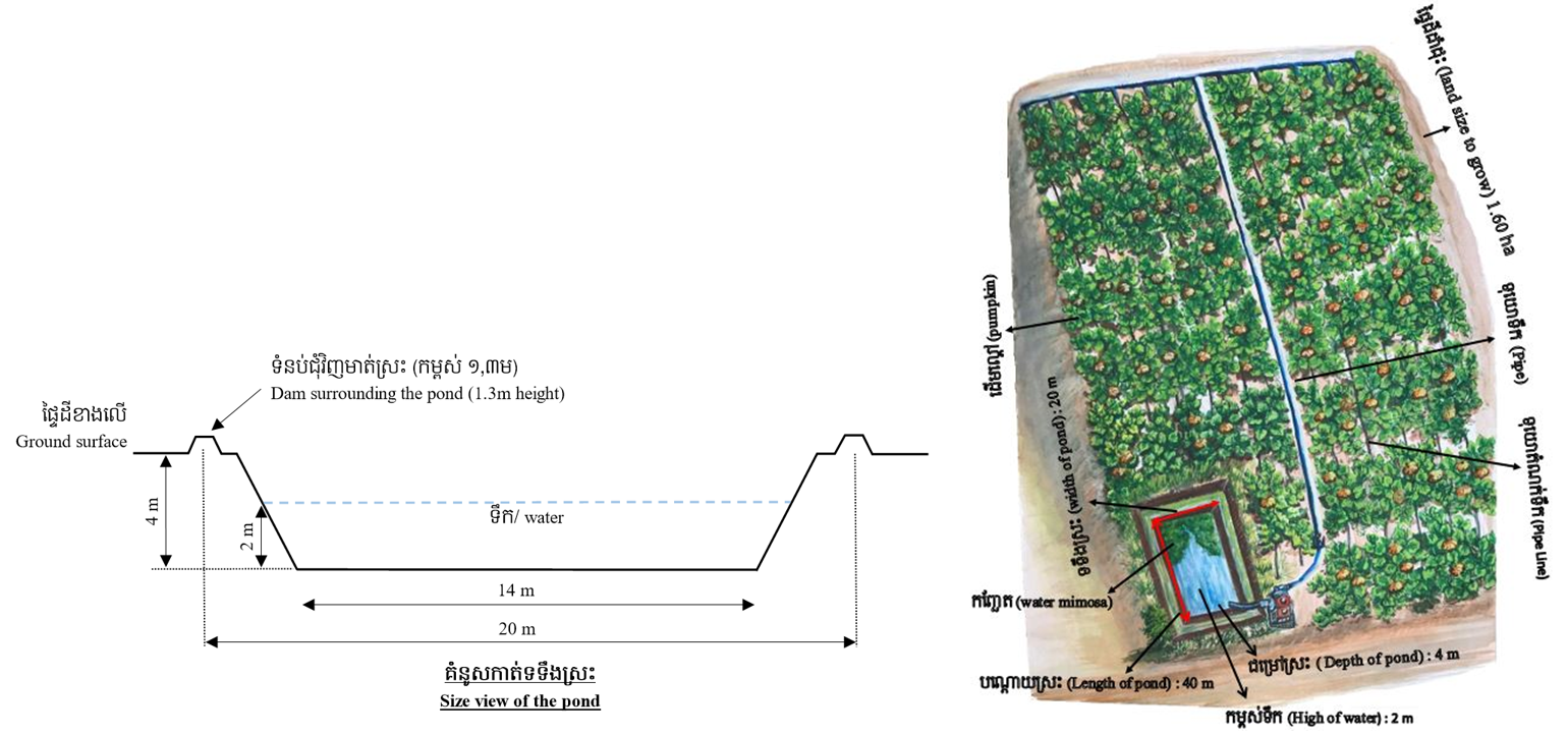
Author:
Mr. Khoun Sophal and Mr. Tim Sophea
Date:
04/05/2017
4.2 Technical specifications/ explanations of technical drawing
Constructed at the lowest part of the land, the pond has a surface size of 40 x 20 meters and bottom size of 29 x 14 meters. The depth is 4 meters with the water level of around 2 meters depth. The water level in the pond remains similar both in dried and rainy seasons. The farmer makes a earth dam around it with 1.3 meters high to protect sedimentation flow into the pond during heavy rainfall. The farmer also plants some local grass surrounding the dam to prevent soil erosion. Some water mimosa was also put in the pond to serves two functions, for filtering the water and as feed for fish in the pond.
4.3 General information regarding the calculation of inputs and costs
Specify how costs and inputs were calculated:
- per Technology unit
Specify unit:
Pond and irrigation system
Specify volume, length, etc. (if relevant):
800 square meters for pond, pipe (main line and sub main line) 220 meters, and tube 500 meters
other/ national currency (specify):
Riel
Indicate exchange rate from USD to local currency (if relevant): 1 USD =:
4000.0
Indicate average wage cost of hired labour per day:
20000 Riel
4.4 Establishment activities
| Activity | Type of measure | Timing | |
|---|---|---|---|
| 1. | Digging pond with excavator | Structural | December |
| 2. | Building a dam surrounding the pond | Structural | December |
| 3. | Motor pump | Other measures | December |
| 4. | Set up drip irrigation | Structural | February |
| 5. | Plant local grass on the dam and put water mimosa in the pond | Vegetative | May |
Comments:
Renting fee of an excavator is 200,000 Riel per hour.
4.5 Costs and inputs needed for establishment
| Specify input | Unit | Quantity | Costs per Unit | Total costs per input | % of costs borne by land users | |
|---|---|---|---|---|---|---|
| Labour | Digging pond and making dam (by exscavator) | Hour | 40.0 | 200000.0 | 8000000.0 | |
| Labour | Set up drip irrigation | person-day | 2.0 | 40000.0 | 80000.0 | 100.0 |
| Equipment | Motor pump pipe and tube sets for drip irrigation | Set | 1.0 | 2720000.0 | 2720000.0 | 100.0 |
| Total costs for establishment of the Technology | 10800000.0 | |||||
If land user bore less than 100% of costs, indicate who covered the remaining costs:
The owner of excavator
Comments:
The owner of excavator sold the excavated soil and the farmer received the pond.
4.6 Maintenance/ recurrent activities
| Activity | Type of measure | Timing/ frequency | |
|---|---|---|---|
| 1. | Restore the pond | Structural | Dry season |
| 2. | Fixing the dam | Structural | No rain |
| 3. | Irrigating the crops | Agronomic | During drought |
4.7 Costs and inputs needed for maintenance/ recurrent activities (per year)
| Specify input | Unit | Quantity | Costs per Unit | Total costs per input | % of costs borne by land users | |
|---|---|---|---|---|---|---|
| Labour | Restoring the pond and fixing the dam | person-day | 7.0 | 20000.0 | 140000.0 | 100.0 |
| Construction material | Gasoline for pumping | Liter | 30.0 | 2800.0 | 84000.0 | 100.0 |
| Total costs for maintenance of the Technology | 224000.0 | |||||
4.8 Most important factors affecting the costs
Describe the most determinate factors affecting the costs:
The wage of the excavator for digging the pond is expensive. However, this can be overcome by giving the soil to the excavator who can sell the soil and therewith does the work for free.
5. Natural and human environment
5.1 Climate
Annual rainfall
- < 250 mm
- 251-500 mm
- 501-750 mm
- 751-1,000 mm
- 1,001-1,500 mm
- 1,501-2,000 mm
- 2,001-3,000 mm
- 3,001-4,000 mm
- > 4,000 mm
Specify average annual rainfall (if known), in mm:
1102.02
Specifications/ comments on rainfall:
The annual rainfall was 1,393 mm, 878.13 mm and 1,102.02 mm, in 2013, 2014 and 2015 respectively.
Indicate the name of the reference meteorological station considered:
Ministry of Water Resources and Meteorology (2015)
Agro-climatic zone
- sub-humid
There are 2 seasons: dry and rainy seasons
5.2 Topography
Slopes on average:
- flat (0-2%)
- gentle (3-5%)
- moderate (6-10%)
- rolling (11-15%)
- hilly (16-30%)
- steep (31-60%)
- very steep (>60%)
Landforms:
- plateau/plains
- ridges
- mountain slopes
- hill slopes
- footslopes
- valley floors
Altitudinal zone:
- 0-100 m a.s.l.
- 101-500 m a.s.l.
- 501-1,000 m a.s.l.
- 1,001-1,500 m a.s.l.
- 1,501-2,000 m a.s.l.
- 2,001-2,500 m a.s.l.
- 2,501-3,000 m a.s.l.
- 3,001-4,000 m a.s.l.
- > 4,000 m a.s.l.
Indicate if the Technology is specifically applied in:
- concave situations
Comments and further specifications on topography:
The land has a slope of around 9 degrees.
5.3 Soils
Soil depth on average:
- very shallow (0-20 cm)
- shallow (21-50 cm)
- moderately deep (51-80 cm)
- deep (81-120 cm)
- very deep (> 120 cm)
Soil texture (topsoil):
- medium (loamy, silty)
Soil texture (> 20 cm below surface):
- coarse/ light (sandy)
Topsoil organic matter:
- medium (1-3%)
If available, attach full soil description or specify the available information, e.g. soil type, soil PH/ acidity, Cation Exchange Capacity, nitrogen, salinity etc.
The underground soil is sandy and and the top soil is sandy loam with pH of 4,5.
5.4 Water availability and quality
Ground water table:
5-50 m
Availability of surface water:
good
Water quality (untreated):
for agricultural use only (irrigation)
Is water salinity a problem?
No
Is flooding of the area occurring?
No
5.5 Biodiversity
Species diversity:
- low
Habitat diversity:
- low
5.6 Characteristics of land users applying the Technology
Sedentary or nomadic:
- Sedentary
Market orientation of production system:
- commercial/ market
Off-farm income:
- less than 10% of all income
Relative level of wealth:
- average
Individuals or groups:
- individual/ household
Level of mechanization:
- mechanized/ motorized
Gender:
- men
Age of land users:
- middle-aged
Indicate other relevant characteristics of the land users:
The farmer who owns the described pond is 34 years old.
5.7 Average area of land owned or leased by land users applying the Technology
- < 0.5 ha
- 0.5-1 ha
- 1-2 ha
- 2-5 ha
- 5-15 ha
- 15-50 ha
- 50-100 ha
- 100-500 ha
- 500-1,000 ha
- 1,000-10,000 ha
- > 10,000 ha
Is this considered small-, medium- or large-scale (referring to local context)?
- medium-scale
Comments:
The farmer owns land of 2 hectares (rice field and crop cultivation) and 6 hectares of rental land.
5.8 Land ownership, land use rights, and water use rights
Land ownership:
- individual, titled
- land rent
Land use rights:
- leased
- individual
Water use rights:
- individual
5.9 Access to services and infrastructure
health:
- poor
- moderate
- good
education:
- poor
- moderate
- good
technical assistance:
- poor
- moderate
- good
employment (e.g. off-farm):
- poor
- moderate
- good
markets:
- poor
- moderate
- good
energy:
- poor
- moderate
- good
roads and transport:
- poor
- moderate
- good
drinking water and sanitation:
- poor
- moderate
- good
financial services:
- poor
- moderate
- good
6. Impacts and concluding statements
6.1 On-site impacts the Technology has shown
Socio-economic impacts
Production
crop production
Comments/ specify:
The farmer can cultivate more crops including pumpkin during the dry season.
crop quality
Comments/ specify:
The crop is healthier and produces better yields due to the sufficient irrigated water.
risk of production failure
Comments/ specify:
Have enough water for irrigation during drought
product diversity
Comments/ specify:
Possible to grow multiple crops
land management
Quantity before SLM:
soil less moisture
Quantity after SLM:
soil have more moisture than before
Comments/ specify:
The pond provides sufficient water to the land.
Water availability and quality
drinking water availability
Comments/ specify:
The water from the pond can be used for drinking after properly boiled.
drinking water quality
Comments/ specify:
The water from the pond can be used for drinking after properly boiled.
irrigation water availability
Comments/ specify:
The pond provides sufficient water in all seasons.
irrigation water quality
Comments/ specify:
Water from the pond is not mineral contaminated like that pumping directly from a well.
demand for irrigation water
Comments/ specify:
Growing more crops, but moderating the demand of water due to the use of drip irrigation system.
Income and costs
expenses on agricultural inputs
Comments/ specify:
Growing more crops and using drip irrigation system.
farm income
Comments/ specify:
Received good yield of every crop after having enough irrigation water.
Socio-cultural impacts
SLM/ land degradation knowledge
Comments/ specify:
Growing more crops, the farmer has more knowledge and experience with the practices.
Ecological impacts
Water cycle/ runoff
water quantity
Comments/ specify:
The water is available from the pond.
water quality
Comments/ specify:
The dam and the water mimosa protect water quality in the pond.
harvesting/ collection of water
Comments/ specify:
The pond collects both rainwater and groundwater.
groundwater table/ aquifer
Comments/ specify:
The pond links with groundwater aquifer.
Soil
soil moisture
Comments/ specify:
More crops as soil cover and with sufficient irrigated water
soil cover
Comments/ specify:
More crops in all seasons due to the available irrigated water
soil loss
Comments/ specify:
More crops in all seasons as vegetation cover
Biodiversity: vegetation, animals
plant diversity
Comments/ specify:
The water availability is conducive for pants to grow.
Climate and disaster risk reduction
drought impacts
Comments/ specify:
The pond can address the problem of drought as it provides enough water even during drought of the area.
6.2 Off-site impacts the Technology has shown
damage on neighbours' fields
Comments/ specify:
Some neighbors also use water from the pond for domestic purposes.
Comments regarding impact assessment:
The neighbors can use water regularly due to its availability.
6.3 Exposure and sensitivity of the Technology to gradual climate change and climate-related extremes/ disasters (as perceived by land users)
Gradual climate change
Gradual climate change
| Season | Type of climatic change/ extreme | How does the Technology cope with it? | |
|---|---|---|---|
| annual temperature | increase | moderately | |
| seasonal temperature | wet/ rainy season | increase | very well |
| annual rainfall | decrease | very well | |
| seasonal rainfall | wet/ rainy season | decrease | very well |
| other gradual climate change | Heat increase than before | increase | very well |
Climate-related extremes (disasters)
Biological disasters
| How does the Technology cope with it? | |
|---|---|
| epidemic diseases | moderately |
| insect/ worm infestation | moderately |
Comments:
Once there is a pond, the farmer can grow more vegetables or other crops.
6.4 Cost-benefit analysis
How do the benefits compare with the establishment costs (from land users’ perspective)?
Short-term returns:
positive
Long-term returns:
positive
How do the benefits compare with the maintenance/ recurrent costs (from land users' perspective)?
Short-term returns:
positive
Long-term returns:
positive
Comments:
Other people are interested to have ponds but they are afraid that the groundwater aquifer is too deep on their land and they then don't have enough water in pond.
6.5 Adoption of the Technology
- single cases/ experimental
Of all those who have adopted the Technology, how many have did so spontaneously, i.e. without receiving any material incentives/ payments?
- 90-100%
Comments:
There was no other farmer in this area doing like this as they are afraid that the water source is not enough and they would lose the money for investing in it.
6.6 Adaptation
Has the Technology been modified recently to adapt to changing conditions?
No
6.7 Strengths/ advantages/ opportunities of the Technology
| Strengths/ advantages/ opportunities in the land user’s view |
|---|
| Sufficient water is made available for irrigation of crops |
| Crops can be grown outside the period of regular cropping based on rainfall distribution |
| Strengths/ advantages/ opportunities in the compiler’s or other key resource person’s view |
|---|
| Water can be stored for irrigation in the dry season and for use during periods of drought |
| Neighbors can be given access to water stored in the ponds |
| Small-scale aquaculture becomes potentially possible, with the potential for the cultivation of some aquatic plants as vegetables |
6.8 Weaknesses/ disadvantages/ risks of the Technology and ways of overcoming them
| Weaknesses/ disadvantages/ risks in the land user’s view | How can they be overcome? |
|---|---|
| Loss of some land from crop cultivation due to the pond | Change to using the land to raise fish |
| Need to restore the pond within every two or three years | Hire someone to do it |
| Digging pond is expensive | Seek collaborate with a partner like the person who owns an excavator for mutual benefits |
| Weaknesses/ disadvantages/ risks in the compiler’s or other key resource person’s view | How can they be overcome? |
|---|---|
| Reduced area of cultivated land | Can change the use of the land to grow some aquatic plants and raise fish |
| Digging pond is expensive | Seek some support from a project or NGOs, or collaborate with a partner like the person who owns a excavator for mutual benefits |
7. References and links
7.1 Methods/ sources of information
- field visits, field surveys
1 persons
- interviews with land users
1 person
- interviews with SLM specialists/ experts
4 persons
7.3 Links to relevant information which is available online
Title/ description:
Sustainable Cambodia.(2010). Water & Related Programs Report. retreived 18/01/2018 from
URL:
http://www.sustainablecambodia.org/RetrieveDocument.asp?f=Sustainable+Cambodia+Water+%26+Related+Programs+Report%2Epdf
Title/ description:
Kaufmann,C.(2016).Use of household ponds for garden irrigation and fish production.Centre for Development and Environment. retreived 18/01/2018 from
URL:
https://www.google.com/search?q=Use+of+household+ponds+for+garden+irrigation+and+fish+production&ie=utf-8&oe=utf-8&client=firefox-b-ab
Links and modules
Expand all Collapse allLinks
No links
Modules
No modules