Rehabilitation and protection of the rangeland of Guidan Issa [Niger]
- Creation:
- Update:
- Compiler: Maman Aicha
- Editor: –
- Reviewer: David Beritault
technologies_689 - Niger
View sections
Expand all Collapse all1. General information
1.2 Contact details of resource persons and institutions involved in the assessment and documentation of the Technology
Key resource person(s)
land user:
Maman Aichatou
0022796978271 / 0022796769648
achdoutchi@yahoo.fr / abdoulhadikassoum@yahoo.fr
Zamtapo
BP 391
Niger
Name of project which facilitated the documentation/ evaluation of the Technology (if relevant)
Book project: where people and their land are safer - A Compendium of Good Practices in Disaster Risk Reduction (DRR) (where people and their land are safer)Name of the institution(s) which facilitated the documentation/ evaluation of the Technology (if relevant)
HEKS (Hilfswerk der Evangelischen Kirchen Schweiz) (HEKS (Hilfswerk der Evangelischen Kirchen Schweiz)) - Switzerland1.3 Conditions regarding the use of data documented through WOCAT
When were the data compiled (in the field)?
26/10/2016
The compiler and key resource person(s) accept the conditions regarding the use of data documented through WOCAT:
Yes
1.4 Declaration on sustainability of the described Technology
Is the Technology described here problematic with regard to land degradation, so that it cannot be declared a sustainable land management technology?
No
2. Description of the SLM Technology
2.1 Short description of the Technology
Definition of the Technology:
The rehabilitation of a rangeland consists of fencing and subsequently seeding with herbaceous plants adapted to arid zones and to degraded soils.
2.2 Detailed description of the Technology
Description:
The demographic pressure combined with the increase of livestock has lead to the uncontrolled use of corridors, rangeland and of the surroundings of watering points, which were implemented in the past. The occupation of these areas, dedicated to livestock production, has generated harmful socio-economic impacts:
- a deficiency of pasture resources,
- a multiplication of conflicts between farmers and stock breeders.
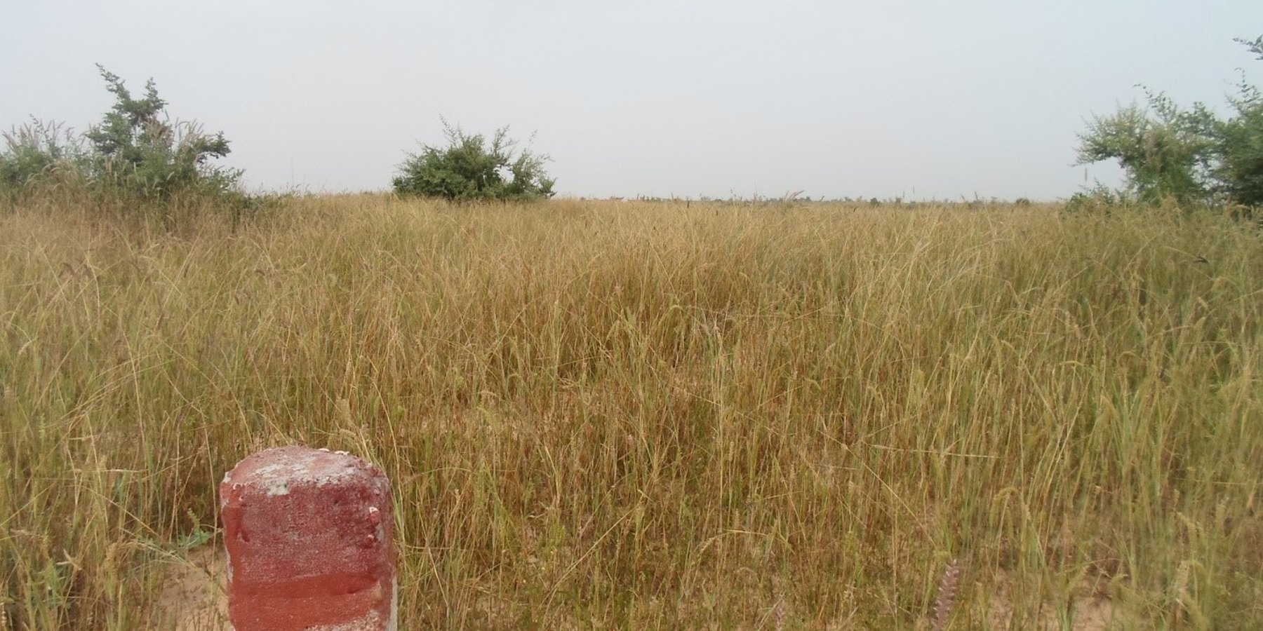
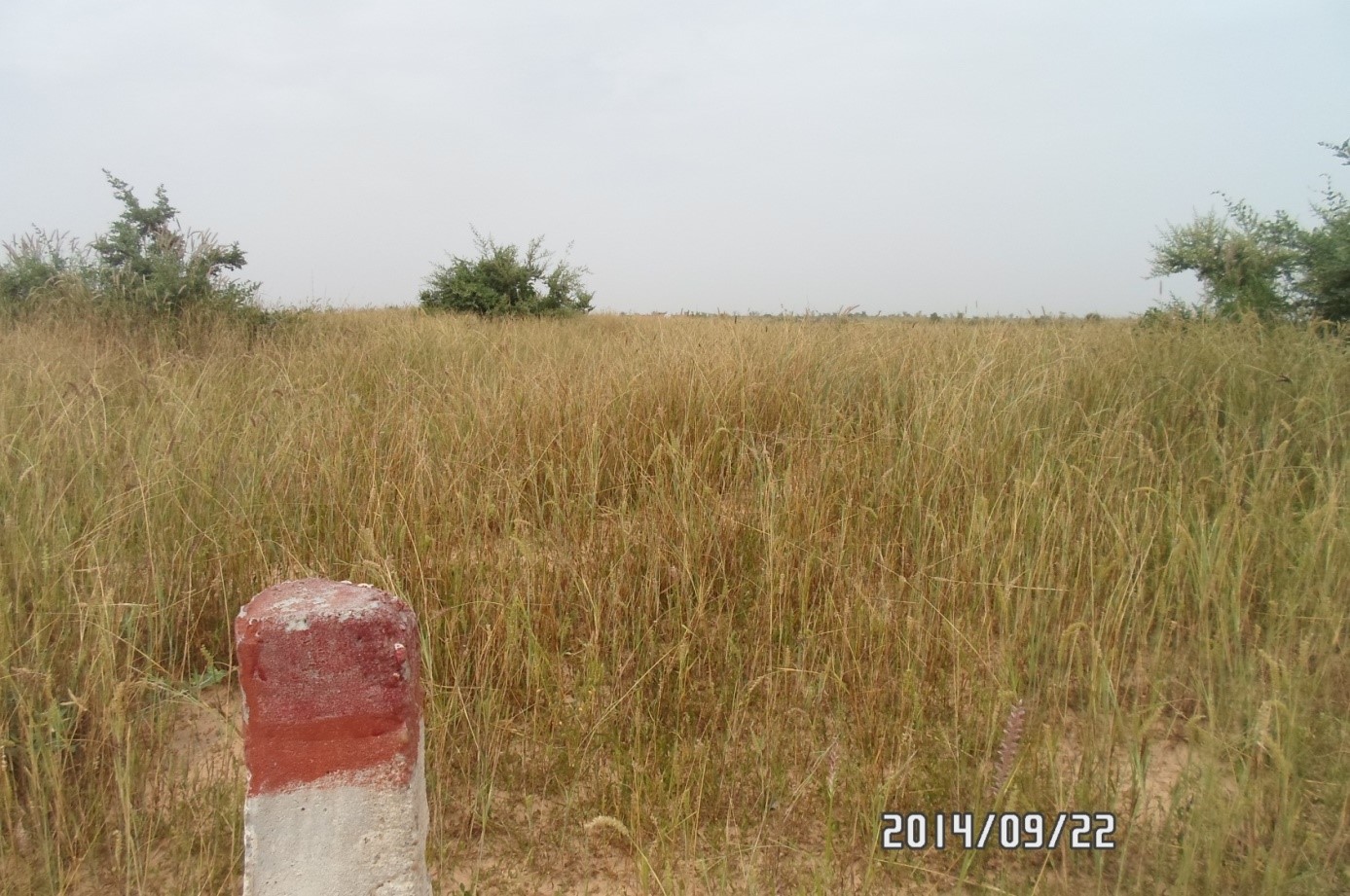
In this context of degrading natural resources, the population of Guidan Issa has requested - through the departmental and municipal authorities - for methodological and financial support of the project Zamtapo. The envisaged rehabilitation does not only include fencing, but also seeding of some herbaceous plants like the Cencrus biflorus (a thorny herbaceous plant of the grass (Poaceae) family, the seeds of which get caught on clothing), and the Adropogon gayanus. These are adapted to arid and semi-arid zones, are generally found on sandy soils, and are much liked by grazing animals.
For the fencing, which constitutes the first stage of the technology, the operation consists of establishing fence posts reinforced with concrete at 50 m intervals. The fencing itself is set-up after the demarcation, and is meant to formalise the operation. A total of 200 fence posts have been
established in the area, which covers 29,5 ha.
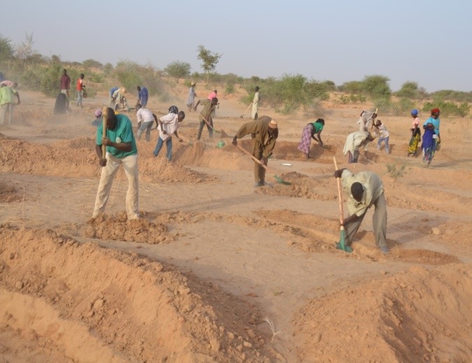
For seeding the rangeland, the selected structures are semi-circular bunds (half-moons), basins in a semicircular shape, which are a soil and water conservation measure (SWC). The excavated earth is deposited on the boundary of the basin in a semi-circular bund, which is flattened at the top. The half-moons are dug in by pivoting with help of a compass with a radius of 2 m. The dimensions commonly applied are: a diameter of 4 m and a depth of 0,15 to 0,25 m. The objective of seeding in half-moons is to restore degraded soils, to conserve rainwater and to improve the soil fertility.
The necessary inputs to implement and maintain the technology are: equipment for constructing soil and water conservation structures, fence posts of reinforced concrete to demarcate the boundaries of the area, and forage seed to sow the bare area.
The advantages of this technology are that it reduces conflicts over land, and promotes excellent livestock farming.
2.3 Photos of the Technology
Media Gallery
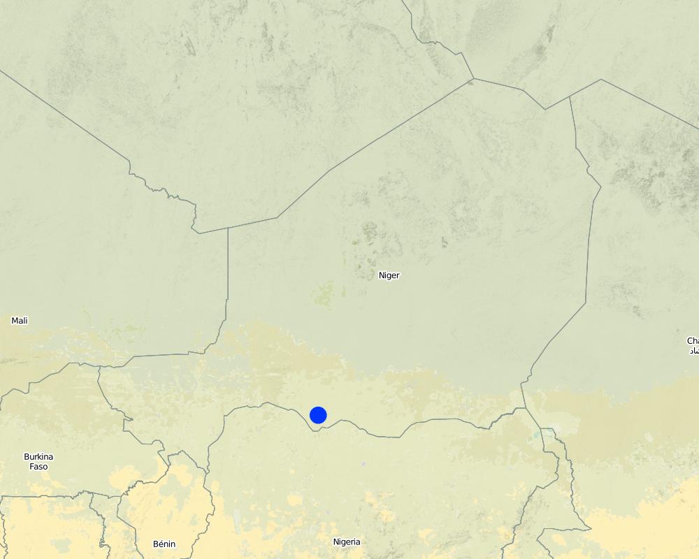
2.5 Country/ region/ locations where the Technology has been applied and which are covered by this assessment
Country:
Niger
Region/ State/ Province:
Department of Mayahi, Maradi region
Map
×2.6 Date of implementation
If precise year is not known, indicate approximate date:
- less than 10 years ago (recently)
2.7 Introduction of the Technology
Specify how the Technology was introduced:
- through projects/ external interventions
Comments (type of project, etc.):
Project to support the secure mobility of livestock in the region of Maradi/Niger (ZAMTAPO with funding from HEKS)
3. Classification of the SLM Technology
3.1 Main purpose(s) of the Technology
- improve production
- reduce, prevent, restore land degradation
- create beneficial economic impact
- create beneficial social impact
3.2 Current land use type(s) where the Technology is applied

Grazing land
Extensive grazing land:
- Semi-nomadism/ pastoralism
Intensive grazing/ fodder production:
- Improved pastures
Main animal species and products:
Sheep, cattle, camelid, goat
Comments:
The area is only used for grazing.
If land use has changed due to the implementation of the Technology, indicate land use before implementation of the Technology:
Before the establishment of the technology, the area was bare; there was no fodder for the animals.
3.3 Further information about land use
Water supply for the land on which the Technology is applied:
- rainfed
Comments:
The main growing season is from July to September (rainy season).
Number of growing seasons per year:
- 1
3.4 SLM group to which the Technology belongs
- pastoralism and grazing land management
- improved ground/ vegetation cover
3.5 Spread of the Technology
Specify the spread of the Technology:
- evenly spread over an area
If the Technology is evenly spread over an area, indicate approximate area covered:
- 0.1-1 km2
Comments:
The area of Guidan Issa has a surface area of 29 ha.
3.6 SLM measures comprising the Technology

vegetative measures
- V2: Grasses and perennial herbaceous plants

structural measures
- S6: Walls, barriers, palisades, fences

management measures
- M1: Change of land use type
3.7 Main types of land degradation addressed by the Technology

biological degradation
- Bc: reduction of vegetation cover
- Bq: quantity/ biomass decline
- Bs: quality and species composition/ diversity decline
3.8 Prevention, reduction, or restoration of land degradation
Specify the goal of the Technology with regard to land degradation:
- restore/ rehabilitate severely degraded land
4. Technical specifications, implementation activities, inputs, and costs
4.1 Technical drawing of the Technology
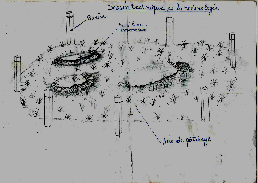
4.2 Technical specifications/ explanations of technical drawing
The excavated earth is deposited on the border of the semi-circle in a semi-circular bund with a flattened top. The half-moons are dug in by pivoting with help of a compass with a radius of 2 m. The dimensions commonly applied are: a diameter of 4 m and a depth of 0,15 to 0,25 m. The objective of seeding in half-moons is to rehabilitate degraded soils, to conserve rainwater and to improve the soil fertility.
4.3 General information regarding the calculation of inputs and costs
Specify how costs and inputs were calculated:
- per Technology area
Indicate size and area unit:
29,5 ha
other/ national currency (specify):
CFA francs
Indicate exchange rate from USD to local currency (if relevant): 1 USD =:
550.0
Indicate average wage cost of hired labour per day:
1500 CFA francs
4.4 Establishment activities
| Activity | Type of measure | Timing | |
|---|---|---|---|
| 1. | Fencing | Structural | March |
| 2. | Registration in the rural land register | Management | March |
| 3. | Laying-out (construction of the half-moons) | Structural | June (before the rainy season) |
| 4. | Seeding | Vegetative | July (during the rainy season) |
| 5. | Training in techniques for seed collection | Management | October |
4.5 Costs and inputs needed for establishment
| Specify input | Unit | Quantity | Costs per Unit | Total costs per input | % of costs borne by land users | |
|---|---|---|---|---|---|---|
| Labour | Labour | person-days | 138.0 | 1500.0 | 207000.0 | 25.0 |
| Equipment | Shovels | 138.0 | 1000.0 | 138000.0 | ||
| Equipment | Hoes | 138.0 | 1000.0 | 138000.0 | ||
| Equipment | Fence posts | 200.0 | 16000.0 | 3200000.0 | ||
| Plant material | Chencrus biflorus | kg | 87.0 | 5000.0 | 435000.0 | 25.0 |
| Plant material | Adropogon gayanus | kg | 120.0 | 5000.0 | 600000.0 | |
| Total costs for establishment of the Technology | 4718000.0 | |||||
If land user bore less than 100% of costs, indicate who covered the remaining costs:
The Zamtapo project has financed the remaining costs.
Comments:
The grazing area of Guidan Issa has a surface area of 29,5 ha. 138 producers (men/women) with 138 shovels and hoes worked in the area during 10 days. There is no need for fertiliser, and the fencing is included.
4.8 Most important factors affecting the costs
Describe the most determinate factors affecting the costs:
- The fencing
- The purchase of seeds
5. Natural and human environment
5.1 Climate
Annual rainfall
- < 250 mm
- 251-500 mm
- 501-750 mm
- 751-1,000 mm
- 1,001-1,500 mm
- 1,501-2,000 mm
- 2,001-3,000 mm
- 3,001-4,000 mm
- > 4,000 mm
Specifications/ comments on rainfall:
The rainy season is between July and September.
Indicate the name of the reference meteorological station considered:
Mayahi
Agro-climatic zone
- semi-arid
5.2 Topography
Slopes on average:
- flat (0-2%)
- gentle (3-5%)
- moderate (6-10%)
- rolling (11-15%)
- hilly (16-30%)
- steep (31-60%)
- very steep (>60%)
Landforms:
- plateau/plains
- ridges
- mountain slopes
- hill slopes
- footslopes
- valley floors
Altitudinal zone:
- 0-100 m a.s.l.
- 101-500 m a.s.l.
- 501-1,000 m a.s.l.
- 1,001-1,500 m a.s.l.
- 1,501-2,000 m a.s.l.
- 2,001-2,500 m a.s.l.
- 2,501-3,000 m a.s.l.
- 3,001-4,000 m a.s.l.
- > 4,000 m a.s.l.
Indicate if the Technology is specifically applied in:
- not relevant
5.3 Soils
Soil depth on average:
- very shallow (0-20 cm)
- shallow (21-50 cm)
- moderately deep (51-80 cm)
- deep (81-120 cm)
- very deep (> 120 cm)
Soil texture (topsoil):
- coarse/ light (sandy)
Soil texture (> 20 cm below surface):
- coarse/ light (sandy)
Topsoil organic matter:
- medium (1-3%)
5.4 Water availability and quality
Ground water table:
> 50 m
Availability of surface water:
medium
Water quality (untreated):
poor drinking water (treatment required)
Is water salinity a problem?
No
Is flooding of the area occurring?
No
5.5 Biodiversity
Species diversity:
- low
Habitat diversity:
- low
5.6 Characteristics of land users applying the Technology
Sedentary or nomadic:
- Semi-nomadic
Market orientation of production system:
- mixed (subsistence/ commercial
Off-farm income:
- less than 10% of all income
Relative level of wealth:
- poor
Individuals or groups:
- individual/ household
Level of mechanization:
- manual work
Gender:
- women
- men
Age of land users:
- middle-aged
5.7 Average area of land owned or leased by land users applying the Technology
- < 0.5 ha
- 0.5-1 ha
- 1-2 ha
- 2-5 ha
- 5-15 ha
- 15-50 ha
- 50-100 ha
- 100-500 ha
- 500-1,000 ha
- 1,000-10,000 ha
- > 10,000 ha
Is this considered small-, medium- or large-scale (referring to local context)?
- small-scale
5.8 Land ownership, land use rights, and water use rights
Land ownership:
- individual, not titled
Land use rights:
- open access (unorganized)
- communal (organized)
Water use rights:
- open access (unorganized)
5.9 Access to services and infrastructure
health:
- poor
- moderate
- good
education:
- poor
- moderate
- good
technical assistance:
- poor
- moderate
- good
employment (e.g. off-farm):
- poor
- moderate
- good
markets:
- poor
- moderate
- good
energy:
- poor
- moderate
- good
roads and transport:
- poor
- moderate
- good
drinking water and sanitation:
- poor
- moderate
- good
financial services:
- poor
- moderate
- good
6. Impacts and concluding statements
6.1 On-site impacts the Technology has shown
Socio-economic impacts
Production
fodder production
Quantity after SLM:
29.91 tonnes of dry matter
Comments/ specify:
The rangeland was a bare area without any fodder before the land management. But after the rehabilitation the area has regenerated.
Socio-cultural impacts
conflict mitigation
Comments/ specify:
The conflicts have been mitigated, the animals do not enter the fields of the farmers anymore, because they have sufficient space and fodder.
Ecological impacts
Biodiversity: vegetation, animals
biomass/ above ground C
Quantity before SLM:
No fodder
Quantity after SLM:
28995 g DM/ha
Other ecological impacts
Increase of the vegetation cover
Comments/ specify:
The vegetation cover has considerably increased, which has made fodder available since the implementation of the technology.
6.2 Off-site impacts the Technology has shown
Comments regarding impact assessment:
The fodder collected in the area was used as hay for the animals and to provide seed for other bare areas.
6.3 Exposure and sensitivity of the Technology to gradual climate change and climate-related extremes/ disasters (as perceived by land users)
Gradual climate change
Gradual climate change
| Season | Type of climatic change/ extreme | How does the Technology cope with it? | |
|---|---|---|---|
| annual temperature | increase | moderately | |
| annual rainfall | decrease | moderately |
6.4 Cost-benefit analysis
How do the benefits compare with the establishment costs (from land users’ perspective)?
Short-term returns:
slightly negative
Long-term returns:
very positive
How do the benefits compare with the maintenance/ recurrent costs (from land users' perspective)?
Short-term returns:
very positive
Long-term returns:
very positive
6.5 Adoption of the Technology
- single cases/ experimental
If available, quantify (no. of households and/ or area covered):
There were no land users who implemented the technology in other places than the rangeland.
6.6 Adaptation
Has the Technology been modified recently to adapt to changing conditions?
No
6.7 Strengths/ advantages/ opportunities of the Technology
| Strengths/ advantages/ opportunities in the land user’s view |
|---|
| Production of fodder, reduced risks of conflicts |
| Strengths/ advantages/ opportunities in the compiler’s or other key resource person’s view |
|---|
| Regeneration of the area, reduction of conflicts, production of fodder |
6.8 Weaknesses/ disadvantages/ risks of the Technology and ways of overcoming them
| Weaknesses/ disadvantages/ risks in the land user’s view | How can they be overcome? |
|---|---|
| Risk of conflicts following non-compliance with established rules. | Awareness raising |
| Weaknesses/ disadvantages/ risks in the compiler’s or other key resource person’s view | How can they be overcome? |
|---|---|
| The risk that the technology is abandoned after the project. | Awareness raising |
7. References and links
7.1 Methods/ sources of information
- field visits, field surveys
24
- interviews with land users
24
Links and modules
Expand all Collapse allLinks
No links
Modules
No modules