Natural Vegetative Strips (NVS) [Philippines]
- Creation:
- Update:
- Compiler: Philippine Overview of Conservation Approaches and Technologies
- Editor: –
- Reviewers: Mathias Gurtner, Deborah Niggli, Alexandra Gavilano
technologies_1133 - Philippines
View sections
Expand all Collapse all1. General information
1.2 Contact details of resource persons and institutions involved in the assessment and documentation of the Technology
Key resource person(s)
SLM specialist:
MERCADO Agustin
International Center for Research in Agroforestry ICRAF
Indonesia
SLM specialist:
Rondal José
Bureau of Soils and Water Management
Philippines
SLM specialist:
Garrity Dennis
International Center for Research in Agroforestry ICRAF
Indonesia
Name of project which facilitated the documentation/ evaluation of the Technology (if relevant)
Book project: where the land is greener - Case Studies and Analysis of Soil and Water Conservation Initiatives Worldwide (where the land is greener)Name of the institution(s) which facilitated the documentation/ evaluation of the Technology (if relevant)
Bureau of Soils and Water Management (Bureau of Soils and Water Management) - PhilippinesName of the institution(s) which facilitated the documentation/ evaluation of the Technology (if relevant)
International Centre for Research in Agroforestry (ICRAF) - Kenya1.3 Conditions regarding the use of data documented through WOCAT
The compiler and key resource person(s) accept the conditions regarding the use of data documented through WOCAT:
Yes
1.4 Declaration on sustainability of the described Technology
Is the Technology described here problematic with regard to land degradation, so that it cannot be declared a sustainable land management technology?
No
1.5 Reference to Questionnaire(s) on SLM Approaches (documented using WOCAT)
LANDCARE - Claveria Landcare Association (CLCA) [Philippines]
Associations that help diffuse, at low cost, soil and water conservation technologies among upland farmers to generate income while conserving natural resources.
- Compiler: Romeo Villamin Labios
2. Description of the SLM Technology
2.1 Short description of the Technology
Definition of the Technology:
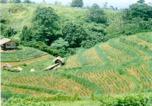
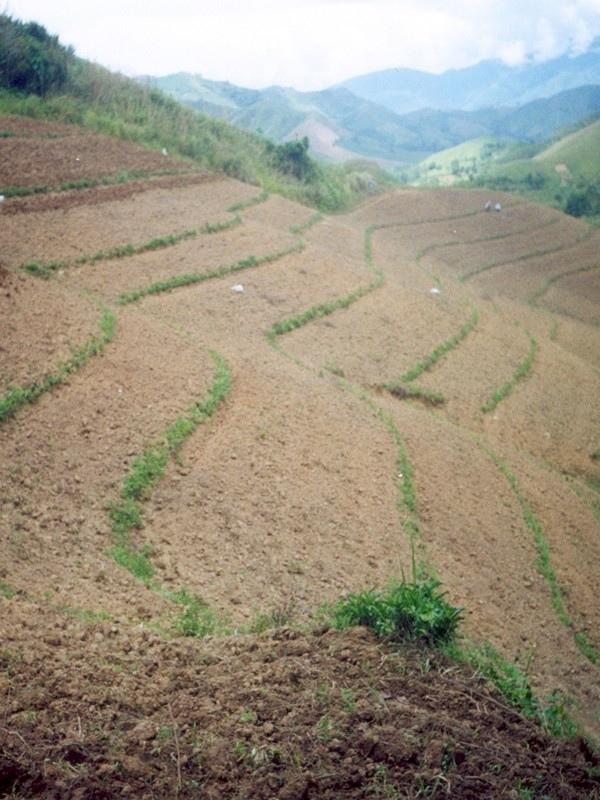
Within individual cropland plots, strips of land are marked out on the contour and left unploughed in order to form permanent, cross-slope barriers of naturally established grasses and herbs.
2.2 Detailed description of the Technology
Description:
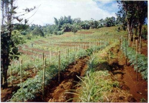
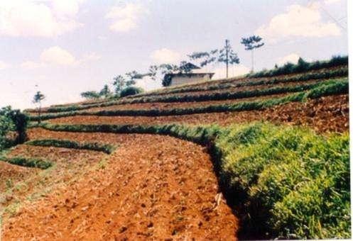
Natural vegetative strips (NVS) are narrow live barriers comprising naturally occurring grasses and herbs. Contour lines are laid out with an A-frame or through the ‘cow's back method’ (a cow is used to walk across the slope: it tends to follow the contour and this is confirmed when its back is seen to be level). The contours are then pegged to serve as an initial guide to ploughing. The 0.3-0.5 m wide strips are left unploughed to allow vegetation to establish. Runoff flowing down the slope during intense rain is slowed, and infiltrates when it reaches the vegetative strips. Eroded soil collects on and above the strips and natural terraces form over time. This levelling is assisted by ploughing along the contour between the NVS - through ‘tillage erosion’ - which also moves soil downslope.
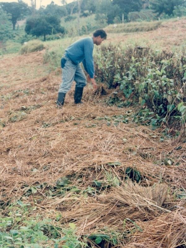
The vegetation on the established NVS needs to be cut back to a height of 5-10 cm: once before planting a crop, and once or twice during the cropping period. The cut material can be incorporated during land preparation, applied to the cropping area as mulch, or used as fodder. This depends on whether the farmer has livestock or not, on personal preference, and on the time of cutting. If the grass is applied as mulch or incorporated, the technology can be considered to be an agronomic, as well as a vegetative, measure.
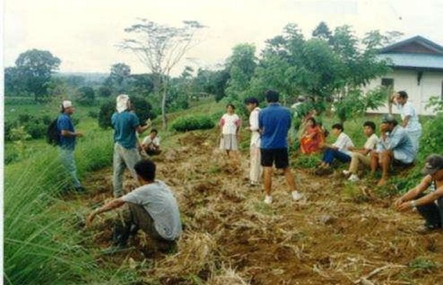
NVS constitutes a low-cost technique because no planting material is required and only minimal labour is necessary for establishment and maintenance. Some farmers had already practiced the technology for several years before the intervention of the ICRAF (The World Agroforestry Centre) in 1993. ICRAF came to realise that farmers here preferred NVS to the recommended ‘contour barrier hedgerows’ of multipurpose trees- which land users viewed as being too labour intensive. When farmers became organised into ‘Landcare’ groups, NVS began to gain wide acceptance.
Land users appreciate the technique because it effectively controls soil erosion and prevents loss (through surface runoff) of fertilizers applied to the crop. As an option, some farmers plant fruit and timber trees, bananas or pineapples on or above the NVS. This may be during establishment of the contour lines, or later. The trees and other cash perennials provide an additional source of income, at the cost of some shading of the adjacent annual crops.
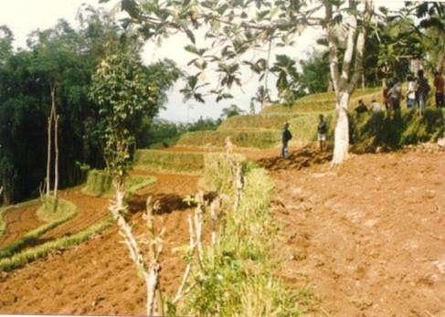
2.3 Photos of the Technology
Media Gallery
2.5 Country/ region/ locations where the Technology has been applied and which are covered by this assessment
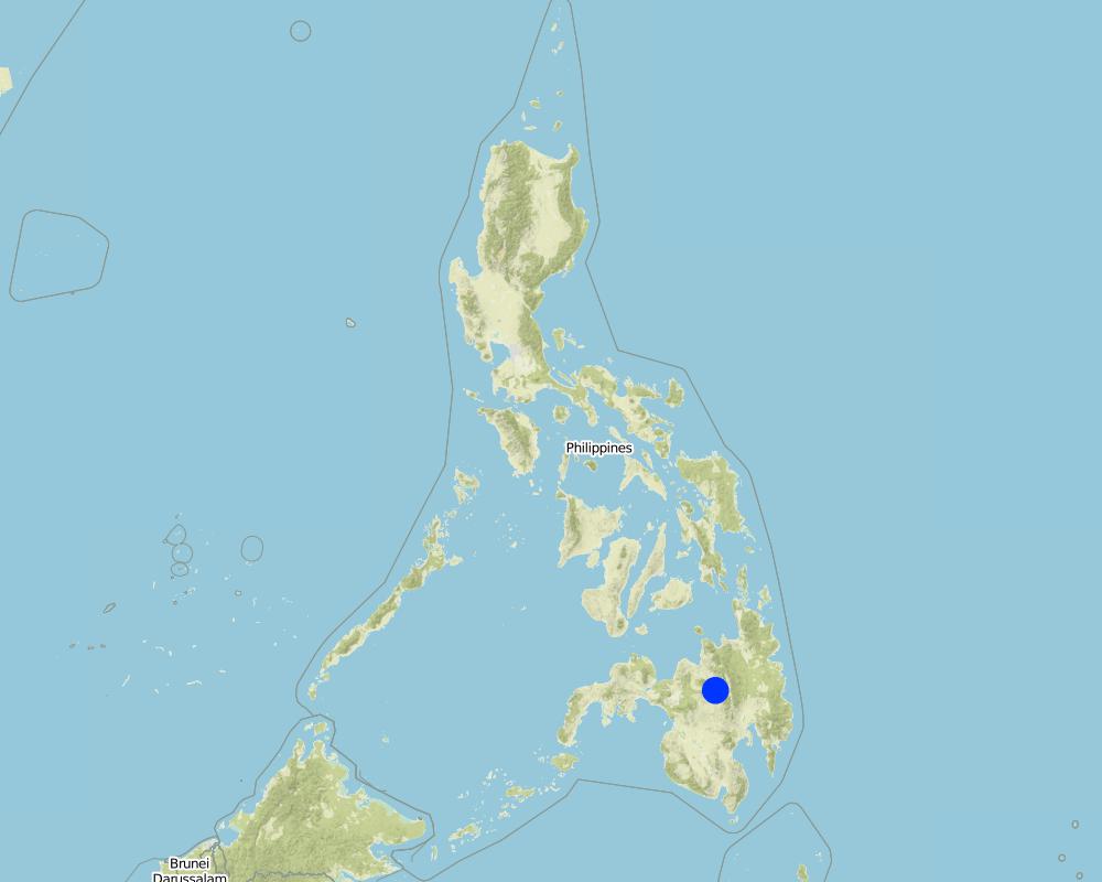
Country:
Philippines
Region/ State/ Province:
Misamis Oriental
Further specification of location:
Bukidnon
Specify the spread of the Technology:
- evenly spread over an area
If the Technology is evenly spread over an area, specify area covered (in km2):
110.0
If precise area is not known, indicate approximate area covered:
- 100-1,000 km2
Comments:
The technology has been practiced by a few farmers for the past several years. With the entry of the International Centre for Research in Agroforestry (ICRAF) in 1993; farmers became organized and the technology gained wide adherence.
Total area covered by the SLM Technology is 110 km2. The technology has been practiced by a few farmers for the past several years. With the entry of the International Centre for Research in Agroforestry (ICRAF) in 1993; farmers became organized and the technology gained wide adherence.
Map
×2.6 Date of implementation
Indicate year of implementation:
1993
If precise year is not known, indicate approximate date:
- less than 10 years ago (recently)
2.7 Introduction of the Technology
Specify how the Technology was introduced:
- through projects/ external interventions
Comments (type of project, etc.):
It evolved in the area with some adaptations.
3. Classification of the SLM Technology
3.1 Main purpose(s) of the Technology
- reduce, prevent, restore land degradation
3.2 Current land use type(s) where the Technology is applied

Cropland
- Annual cropping
- Tree and shrub cropping
Annual cropping - Specify crops:
- cereals - maize
- cereals - rice (upland)
- vegetables - other
Tree and shrub cropping - Specify crops:
- fruits, other
- coffee
Number of growing seasons per year:
- 2
Specify:
Longest growing period: 240 days (Mar - Dec)
Comments:
Main crops (cash and food crops): Maize, vegetables; coffee; fruit trees; upland rice
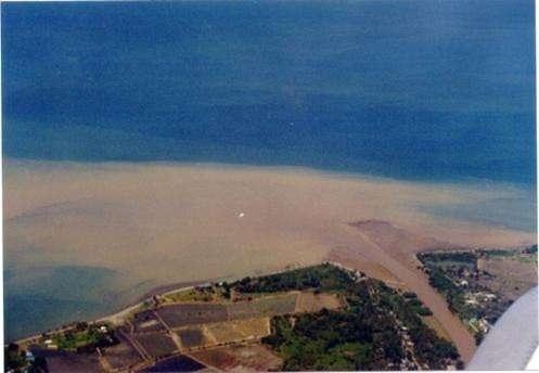
Major land use problems (compiler’s opinion): Loss of topsoil through sheet erosion and rills, leading to rapid soil fertility decline. In turn soil fertility decline results in the need for increasing levels of fertilizer inputs to maintain crop yield. However, these fertilizers are often washed away by surface runoff - a vicious circle.
Major land use problems (land users’ perception): Soil productivity decline; need more inputs to maintain crop yield.
3.4 Water supply
Water supply for the land on which the Technology is applied:
- rainfed
3.5 SLM group to which the Technology belongs
- cross-slope measure
3.6 SLM measures comprising the Technology

agronomic measures
- A1: Vegetation/ soil cover
- A2: Organic matter/ soil fertility
- A3: Soil surface treatment

vegetative measures
- V2: Grasses and perennial herbaceous plants
Comments:
Type of agronomic measures: mixed cropping / intercropping, mulching, legume inter-planting, manure / compost / residues, contour tillage
Type of vegetative measures: aligned: -contour
3.7 Main types of land degradation addressed by the Technology

soil erosion by water
- Wt: loss of topsoil/ surface erosion
- Wg: gully erosion/ gullying

chemical soil deterioration
- Cn: fertility decline and reduced organic matter content (not caused by erosion)
Comments:
Main causes of degradation: deforestation / removal of natural vegetation (incl. forest fires) (caused massive erosion and loss of productivity), Lack of enforcement of legislat./authority (no clear cut policy and support from LGU). Secondary causes of degradation: overgrazing (over population of livestock, low land ratio), education, access to knowledge and support services (farmers are not fully aware of simple SWC approach), Agricultural causes (unsustainable practice in farming)
3.8 Prevention, reduction, or restoration of land degradation
Specify the goal of the Technology with regard to land degradation:
- reduce land degradation
Comments:
Secondary goals: prevention of land degradation, rehabilitation / reclamation of denuded land
4. Technical specifications, implementation activities, inputs, and costs
4.1 Technical drawing of the Technology
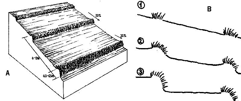
Technical specifications (related to technical drawing):
A - Spacing of natural vegetative strips depends on the slope.
B - The insert shows the evolution of terraces over time through tillage and soil erosion, leading to accumulation of sediment behind the strips (steps 1-3).
Technical knowledge required for field staff / advisors: moderate. Technical knowledge required for land users: moderate.
Main technical functions: reduction of slope angle, reduction of slope length, control of dispersed runoff. Secondary technical functions: improvement of ground cover, increase of infiltration, increase in soil fertility
Agronomic measures:
Mixed cropping / intercropping - Material/ species: annuals/perennials; Remarks: laid out alternately.
Mulching - Material/ species: crop residues; spread on the surface
Legume inter-planting - purpose: for nitrogen fixation
Manure / compost / residues - Material/ species: animal, crop residues
Contour tillage - Material/ species: Contour strips are laid into 6-10 meters apart depending on slope gradient.
Vegetative measures:
Aligned, along contour
Vegetative material: T : trees / shrubs, F : fruit trees / shrubs, C : perennial crops, G : grass, O : other
Vertical interval between rows / strips / blocks (m): 1
Spacing between rows / strips / blocks (m): 5
Vertical interval within rows / strips / blocks (m): 8
Width within rows / strips / blocks (m): 0.5
Narrow grass barriers
Vegetative material: grass
Number of plants per (ha): dense grass
Width within rows / strips / blocks (m): 0.5-0.7
Trees/ shrubs species: Acacia mangium, Eucalyptus deglupta, Gmelina arbarea
Fruit trees / shrubs species: Mango, Durian, Rambutan, Jackfruit
Perennial crops species: Coffee, rubber, pineappe
Grass species: Bamboo, setara, napier, Panicum spp.
Other species: Legumes
Slope (which determines the spacing indicated above): 30%
If the original slope has changed as a result of the Technology, the slope today is (see figure below): 2%
Gradient along the rows / strips: 20%
Author:
Mats Gurtner
4.2 General information regarding the calculation of inputs and costs
Specify how costs and inputs were calculated:
- per Technology area
Indicate size and area unit:
1 ha
Specify currency used for cost calculations:
- USD
4.3 Establishment activities
| Activity | Timing (season) | |
|---|---|---|
| 1. | Layout of contours with the use of an A-frame (or cow’s back method, see Annexe T3)) placing wooden pegs along the contours. | dry season/before land preparation |
| 2. | Seeding (T, F, C) | dry season |
| 3. | Transplanting | onset of rainy season |
| 4. | Land preparation | dry season/before planting |
4.4 Costs and inputs needed for establishment
| Specify input | Unit | Quantity | Costs per Unit | Total costs per input | % of costs borne by land users | |
|---|---|---|---|---|---|---|
| Labour | labour | 1.0 | 15.0 | 15.0 | 100.0 | |
| Equipment | animal traction | 1.0 | 40.0 | 40.0 | 100.0 | |
| Equipment | tools | 1.0 | 25.0 | 25.0 | 100.0 | |
| Equipment | stakes (pegs) | 1.0 | 4.0 | 4.0 | 100.0 | |
| Total costs for establishment of the Technology | 84.0 | |||||
| Total costs for establishment of the Technology in USD | 84.0 | |||||
Comments:
Duration of establishment phase: 12 month(s)
4.5 Maintenance/ recurrent activities
| Activity | Timing/ frequency | |
|---|---|---|
| 1. | Initial ploughing along the contour: leaving unploughed strips. | onset of rainy season / before each season |
| 2. | Planting | onset of rainy season / each cropping season |
| 3. | Mulching | dry season / only whensufficient crop residues |
| 4. | Fertilization | early vegetative stage / each cropping season |
| 5. | Interim cultivation/weeding | vegetative stage / each cropping season |
| 6. | Ploughing mulch into the soil during normal land cultivation. | |
| 7. | Weeding (T, F, C), Slashing grass | rainy season /2 times |
| 8. | Spreading the cut materials evenly in the alleys (between strips) as | rainy season /2 times (weeded materials) |
| 9. | Pruning | before and during cropping /2 times per cropping |
4.6 Costs and inputs needed for maintenance/ recurrent activities (per year)
| Specify input | Unit | Quantity | Costs per Unit | Total costs per input | % of costs borne by land users | |
|---|---|---|---|---|---|---|
| Labour | labour | 1.0 | 36.0 | 36.0 | 100.0 | |
| Equipment | animal traction | 1.0 | 40.0 | 40.0 | 100.0 | |
| Equipment | tools | 1.0 | 2.0 | 2.0 | 100.0 | |
| Total costs for maintenance of the Technology | 78.0 | |||||
| Total costs for maintenance of the Technology in USD | 78.0 | |||||
Comments:
Machinery/ tools: plough, harrow
Costs of establishing contours and maintenance by slashing are calculated by total length of NVS. This example is from a typical field with an 18% slope: at an NVS spacing of 5 m, the approximate total linear distance for one hectare is 2,000 m. In this example, the farmer has paid for everything him/herself (see section on acceptance/adoption). Note that the establishment cost is more or less equivalent to the cost of standard land preparation by ploughing. When 'enrichment planting’ of the strips is carried out, extra cost for seedlings (of fruit trees for example) and associated labour for planting are incurred.
4.7 Most important factors affecting the costs
Describe the most determinate factors affecting the costs:
Slope is the dominant factor in cost calculation. The steeper the slope, the more difficult the mobility is and the more closely-spaced the contours are .
5. Natural and human environment
5.1 Climate
Annual rainfall
- < 250 mm
- 251-500 mm
- 501-750 mm
- 751-1,000 mm
- 1,001-1,500 mm
- 1,501-2,000 mm
- 2,001-3,000 mm
- 3,001-4,000 mm
- > 4,000 mm
Specifications/ comments on rainfall:
Rainfall is more or less evenly distributed throughout the year.
Agro-climatic zone
- humid
- sub-humid
Thermal climate class: tropics
5.2 Topography
Slopes on average:
- flat (0-2%)
- gentle (3-5%)
- moderate (6-10%)
- rolling (11-15%)
- hilly (16-30%)
- steep (31-60%)
- very steep (>60%)
Landforms:
- plateau/plains
- ridges
- mountain slopes
- hill slopes
- footslopes
- valley floors
Altitudinal zone:
- 0-100 m a.s.l.
- 101-500 m a.s.l.
- 501-1,000 m a.s.l.
- 1,001-1,500 m a.s.l.
- 1,501-2,000 m a.s.l.
- 2,001-2,500 m a.s.l.
- 2,501-3,000 m a.s.l.
- 3,001-4,000 m a.s.l.
- > 4,000 m a.s.l.
5.3 Soils
Soil depth on average:
- very shallow (0-20 cm)
- shallow (21-50 cm)
- moderately deep (51-80 cm)
- deep (81-120 cm)
- very deep (> 120 cm)
Soil texture (topsoil):
- medium (loamy, silty)
- fine/ heavy (clay)
Topsoil organic matter:
- medium (1-3%)
- low (<1%)
If available, attach full soil description or specify the available information, e.g. soil type, soil PH/ acidity, Cation Exchange Capacity, nitrogen, salinity etc.
Soils are developed from fine-grained igeneous rocks. Soil fertility: strongly acid and with high P fixing capacity. Rapid organic matter mineralisation due to high temperature. Soil drainage is generally good except in isolated depressions.
5.6 Characteristics of land users applying the Technology
Market orientation of production system:
- subsistence (self-supply)
- mixed (subsistence/ commercial)
Off-farm income:
- 10-50% of all income
Relative level of wealth:
- average
- rich
Level of mechanization:
- animal traction
- mechanized/ motorized
Indicate other relevant characteristics of the land users:
Population density: 50-100 persons/km2; Annual population growth: > 4%
and own 20% of the land (5).
and own 40% of the land (30).
and own 30% of the land (65).
Off-farm income specification: Carpentry, trade, business, labour for neighbouring farms and other labour intensive agricultural activities (e.g. vegetable production)
Market orientation of production system: Upland rice is grown as subsistence. Maize is sold to feed millers.
Level of mechanization: The terrain limits the extensive use of machineries.
5.7 Average area of land used by land users applying the Technology
- < 0.5 ha
- 0.5-1 ha
- 1-2 ha
- 2-5 ha
- 5-15 ha
- 15-50 ha
- 50-100 ha
- 100-500 ha
- 500-1,000 ha
- 1,000-10,000 ha
- > 10,000 ha
Comments:
Subdivision of inheritance lands. High population growth rate attributed to natural birth and envigoration of lowland population create pressure to farm site.
5.8 Land ownership, land use rights, and water use rights
Land ownership:
- individual, not titled
- individual, titled
Land use rights:
- leased
- individual
6. Impacts and concluding statements
6.1 On-site impacts the Technology has shown
Socio-economic impacts
Production
crop production
Comments/ specify:
area competition
fodder production
Comments/ specify:
biomass as fertilizer (or biomass as mulch)
fodder quality
Comments/ specify:
biomass as fertilizer (or biomass as mulch)
production area
Comments/ specify:
crop area loss, before NVS evolved to cash perennials or fodder grasses
land management
Income and costs
expenses on agricultural inputs
Comments/ specify:
during establishment
farm income
Comments/ specify:
biomass was given value
economic disparities
workload
Comments/ specify:
regular pruning
Other socio-economic impacts
very low inputs required
Socio-cultural impacts
community institutions
national institutions
Comments/ specify:
government line agencies and educational institutions
conflict mitigation
Comments/ specify:
negligible socio-cultural conflicts
Ecological impacts
Water cycle/ runoff
surface runoff
Quantity before SLM:
45
Quantity after SLM:
8
excess water drainage
Comments/ specify:
partly increased water-logging (negligible)
Soil
soil moisture
soil cover
soil loss
Quantity before SLM:
40
Quantity after SLM:
2
Comments/ specify:
important for sustainability
Biodiversity: vegetation, animals
plant diversity
pest/ disease control
Comments/ specify:
pest sanctuary
Climate and disaster risk reduction
wind velocity
Other ecological impacts
soil structure
soil fertility
weed infestation due to seed dispersion and grass roots
Comments/ specify:
spreading from the NVS to nearby areas (especially with cogon grass: Imperata cylindrica)
6.2 Off-site impacts the Technology has shown
reliable and stable stream flows in dry season
downstream flooding
Comments/ specify:
no actual measurement
downstream siltation
groundwater/ river pollution
6.4 Cost-benefit analysis
How do the benefits compare with the establishment costs (from land users’ perspective)?
Short-term returns:
positive
Long-term returns:
very positive
How do the benefits compare with the maintenance/ recurrent costs (from land users' perspective)?
Short-term returns:
positive
Long-term returns:
very positive
6.5 Adoption of the Technology
Of all those who have adopted the Technology, how many did so spontaneously, i.e. without receiving any material incentives/ payments?
- 51-90%
Comments:
50% of land user families have adopted the Technology with external material support (2000 families)
50% of land user families have adopted the Technology spontaneously (without external material support) (2000 families)
There is a strong trend towards spontaneous adoption of the Technology. Factor that helped was the formation of Landcare associations which have benefited their members in various ways. There is a strong trend towards spontaneous adoption, especially where Landcare associations are in operation.
6.7 Strengths/ advantages/ opportunities of the Technology
| Strengths/ advantages/ opportunities in the land user’s view |
|---|
| Easy to establish and maintain |
| Improve soil fertility |
| Prevent soil erosion |
| Strengths/ advantages/ opportunities in the compiler’s or other key resource person’s view |
|---|
| Easy to establish and maintain (How to sustain: Transform farmers associations into cooperative which serve as conduits in marketing. Intensify information and education campaign.) |
| Less competition for space, sunlight, moisture and nutrient. (How to sustain: Ensure continued regular trimming of vegetative strips and use of these as fodder or mulch.) |
| Low labor and external inputs requirement |
| Effective in reducing soil erosion (by 90%) (How to sustain: Adopt other supportive technologies like mulching, zero tillage/minimum tillage, etc.) |
6.8 Weaknesses/ disadvantages/ risks of the Technology and ways of overcoming them
| Weaknesses/ disadvantages/ risks in the land user’s view | How can they be overcome? |
|---|---|
| High initial establishment cost | Subsidy/assistance from government |
| Effect of technology is not readily seen | Education about what long term sustainability means |
| High gestation period for some component of the system | Proper mix of annual and perennial crops |
| Weaknesses/ disadvantages/ risks in the compiler’s or other key resource person’s view | How can they be overcome? |
|---|---|
|
Effect on yield and income is not readily felt, since reduced erosion is not easily translated into increased income or yield |
Farmers should have supplementary sources of income (eg livestock). Education about what long-term sustainability means. |
| Reduction of productive area by approx 10% |
Optimum fertilization to offset production loss. Nutrients are conserved under NVS and this will result in the reduction of fertilizer requirement after some years. |
|
Creation of a fertility gradient within the alley (soil is lost from the top of the alley and accumulates above the NVS where fertility then concentrates) |
Increased application of fertilizer on the upper part of alley. |
| Overall increase of production value is low | Land users could ask for subsidy/assistance from Government: eg for fertilizers, establishment of nurseries, free seedlings (for higher value fruit trees). |
7. References and links
7.1 Methods/ sources of information
7.2 References to available publications
Title, author, year, ISBN:
Managing soil fertility on terraces forming behind vegetative filter strips: An assessment of farmer strategies
Available from where? Costs?
ICRAF, P.O. Box 161, Bogor, INDONESIA
Title, author, year, ISBN:
Crop productivity using forage legumes and grasses as contour hedgerows species in an acid upland soils
Available from where? Costs?
ICRAF, P.O. Box 161, Bogor, INDONESIA
Title, author, year, ISBN:
Garrity DP, Stark M and Mercado Jr A: Natural Vegetative Strips: a bioengineering innovation to help transform smallholderconservation. pp 263–270. 2004.
Title, author, year, ISBN:
in Barker DH, Watson AJ, Sombatpanit S, Northcutt B and Maglinao AR Ground and Water Bioengineering for ErosionControl and Slope Stabilisation.
Available from where? Costs?
Science Publishers inc. Enfield, USA
Title, author, year, ISBN:
Stark M, Itumay J and Nulla S Assessment of Natural VegetativeContour Strips for Soil Conservation on Shallow Calcareous Soil in the Central Philippines.. 2003.
Available from where? Costs?
World Agroforestry Centre (ICRAF), Nairobi, Kenya
Links and modules
Expand all Collapse allLinks
LANDCARE - Claveria Landcare Association (CLCA) [Philippines]
Associations that help diffuse, at low cost, soil and water conservation technologies among upland farmers to generate income while conserving natural resources.
- Compiler: Romeo Villamin Labios
Modules
No modules