Cascading Rock Irrigation Channel [Tajikistan]
- Creation:
- Update:
- Compiler: Davlatbek Davlatov
- Editor: –
- Reviewers: Alexandra Gavilano, David Streiff, Joana Eichenberger
Boloi Dasht (Tajik)
technologies_1454 - Tajikistan
View sections
Expand all Collapse all1. General information
1.2 Contact details of resource persons and institutions involved in the assessment and documentation of the Technology
SLM specialist:
Name of project which facilitated the documentation/ evaluation of the Technology (if relevant)
Pilot Program for Climate Resilience, Tajikistan (WB / PPCR)Name of the institution(s) which facilitated the documentation/ evaluation of the Technology (if relevant)
CAMP - Central Asian Mountain Partnership (CAMP - Central Asian Mountain Partnership) - Kyrgyzstan1.3 Conditions regarding the use of data documented through WOCAT
The compiler and key resource person(s) accept the conditions regarding the use of data documented through WOCAT:
Yes
2. Description of the SLM Technology
2.1 Short description of the Technology
Definition of the Technology:
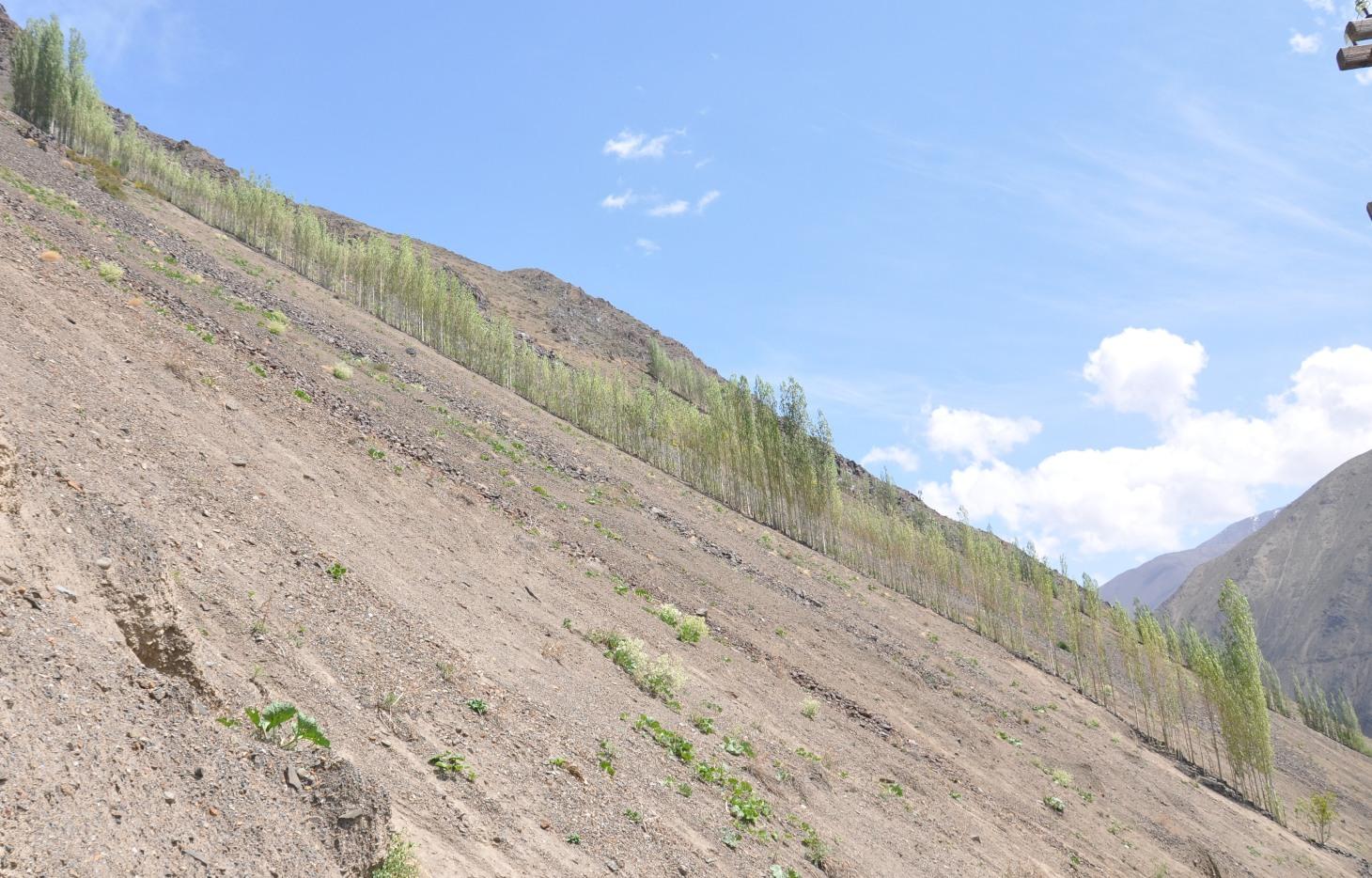
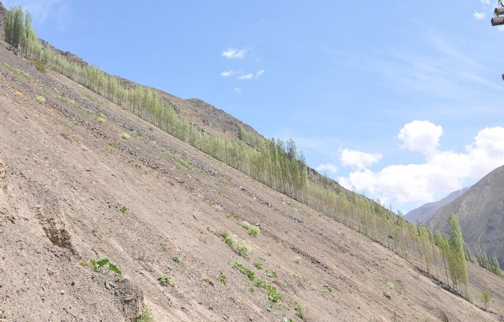
A cascading rock irrigation channel lined with fast growing poplar trees, constructed on rocky slopes to channel water runoff from the high mountains for human use at the valley floor.
2.2 Detailed description of the Technology
Description:
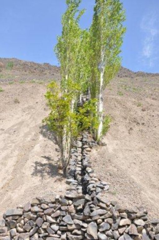
A one metre wide, 300m long, irrigation channel constructed of stones, that is built into the steep slope of a mountain gorge. The channel is 0.5m deep and is lined with poplar trees that help stabilise the structure. The water runs down the channel from the top mountains, with water splashing onto the poplar trees. At the foot of the channel the water is used to irrigated cultivated land and provide drinking water.
Purpose of the Technology: The main purpose of the cascading rock irrigation structure is to capture surface water run-off from the top of the mountain and channel it to where it can be utilised for human use such as drinking water, sanitation, and irrigation. The uneven surface of the rock channel slows the pace of the water thus preventing scouring at the foot of the channel. The channel also provides a suitable environment for the cultivation of poplar trees which in turn can help reduce water and wind erosion on the slopes, thus preventing rock and debris movement down onto the cultivated lands on the valley floor.
Establishment / maintenance activities and inputs: The channel is dug perpendicular to the steep slope and lined with stones gathered from the mountainous slopes. This activity is labour intensive, but can be more efficient with the use of donkeys. The stones are placed upon/on top of each other in the base of the channel, and used to line the sides of the channel to retain the water. The soil along the edge of the channel is cleared of debris and stone until it is suitable for the planting of poplar cuttings. The cutting are supplemented with organic fertiliser. The channel is financed by the land owner, with voluntary support from the community.
Natural / human environment: The cascading rock irrigation channel is located in a remote steep mountainous gorge where there is a shortage of land for cultivation. Water is in short supply, especially during the hot summer months. Subsequently the inhabitants have a high dependency on irrigated water from the top of the mountain range. The majority of the residents have a semi-subsistence living and are highly reliant upon the cultivated land where they grow a range of crops (e.g. wheat, potatoes. etc), fruits (e.g. apricots) and poplar trees for selling and construction purposes.
2.3 Photos of the Technology
2.5 Country/ region/ locations where the Technology has been applied and which are covered by this assessment
Country:
Tajikistan
Region/ State/ Province:
Sogd region
Further specification of location:
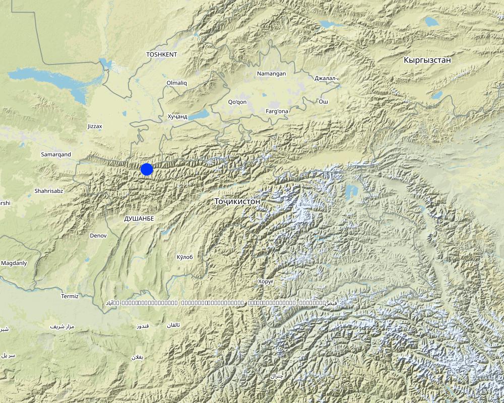
Ayni
Specify the spread of the Technology:
- evenly spread over an area
If precise area is not known, indicate approximate area covered:
- < 0.1 km2 (10 ha)
Comments:
Long and narrow geographical areas were chosen for implementation of the technology. The technology was replicated ten times in this community area.
Map
×2.6 Date of implementation
If precise year is not known, indicate approximate date:
- 10-50 years ago
2.7 Introduction of the Technology
Specify how the Technology was introduced:
- through land users' innovation
Comments (type of project, etc.):
The technology was constructed in 1992 and 1997 based upon ideas generated from the local inhabitants.
3. Classification of the SLM Technology
3.1 Main purpose(s) of the Technology
- reduce, prevent, restore land degradation
- improved access to water
3.2 Current land use type(s) where the Technology is applied

Cropland
- Annual cropping
- Tree and shrub cropping
Annual cropping - Specify crops:
- cereals - wheat (winter)
- root/tuber crops - potatoes
Tree and shrub cropping - Specify crops:
- stone fruits (peach, apricot, cherry, plum, etc)
Number of growing seasons per year:
- 1

Forest/ woodlands
- (Semi-)natural forests/ woodlands
- Tree plantation, afforestation
Tree plantation, afforestation: Specify origin and composition of species:
- Monoculture local variety
Products and services:
- Protection against natural hazards
- construction

Other
Specify:
Wasteland: The mountain slopes are mainly devoid of vegetation.
Comments:
Major land use problems (compiler’s opinion): Water and wind erosion, rockfalls and debris movement.
Major land use problems (land users’ perception): Debris movement due to excessive rains damaging crops and infrastructure.
Selective felling of (semi-) natural forests: Infrequent felling of poplars.
Forest products and services: timber, protection against natural hazards
Other forest products and services: construction
Future (final) land use (after implementation of SLM Technology): Forests / woodlands: Fp: Plantations, afforestations
Constraints of wastelands / deserts / glaciers / swamps
3.3 Has land use changed due to the implementation of the Technology?

Cropland
- Annual cropping
- Tree and shrub cropping
Annual cropping - Specify crops:
- cereals - wheat (spring)
- root/tuber crops - potatoes
Tree and shrub cropping - Specify crops:
- stone fruits (peach, apricot, cherry, plum, etc)

Forest/ woodlands
- Tree plantation, afforestation
3.4 Water supply
Water supply for the land on which the Technology is applied:
- rainfed
Comments:
Number of growing seasons per year:
1
Specify:
Longest growing period in days: 180Longest growing period from month to month: March-October
3.5 SLM group to which the Technology belongs
- cross-slope measure
- irrigation management (incl. water supply, drainage)
- water diversion and drainage
3.6 SLM measures comprising the Technology

agronomic measures
- A1: Vegetation/ soil cover

vegetative measures
- V1: Tree and shrub cover

structural measures
- S3: Graded ditches, channels, waterways
Comments:
Main measures: vegetative measures, structural measures
Type of vegetative measures: aligned: -linear
3.7 Main types of land degradation addressed by the Technology

soil erosion by water
- Wg: gully erosion/ gullying
- Wm: mass movements/ landslides

soil erosion by wind
- Ed: deflation and deposition
Comments:
Main type of degradation addressed: Wm: mass movements / landslides
Secondary types of degradation addressed: Wg: gully erosion / gullying, Ed: deflation and deposition
Main causes of degradation: deforestation / removal of natural vegetation (incl. forest fires) (Removal of forest vegetation many years before.), Heavy / extreme rainfall (intensity/amounts) (Extreme events lead to debris movement covering fertile lands.)
Secondary causes of degradation: war and conflicts (Lack of natural resources during civil war led to the cutting of many of the trees preventing slope movement.)
3.8 Prevention, reduction, or restoration of land degradation
Specify the goal of the Technology with regard to land degradation:
- reduce land degradation
4. Technical specifications, implementation activities, inputs, and costs
4.1 Technical drawing of the Technology
Technical specifications (related to technical drawing):
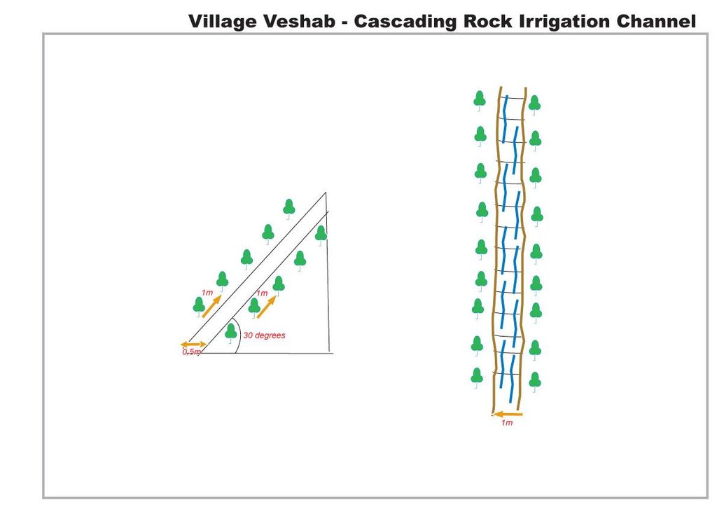
The drawing shows in plan and profile the cascading rock channel. The slope of the mountain is 30 degrees, a one metre wide channel, 0.5 m deep, is dug into the slope. The channel is lined with stones. The soil either side of the channel is cleared of rocks, and poplar branches are planted at 1m intervals lining the channel.
Location: Veshab Boloi Dasht. Ayni Sughd Region Tajikistan
Date: 2011-05-04
Technical knowledge required for land users: moderate (An understanding of how to build the basic structure without it collapsing and able to meet the discharge capacity of the water.)
Main technical functions: control of concentrated runoff: drain / divert, water harvesting / increase water supply, Prevent off site damage to cultivated land at the foot of the slope.
Secondary technical functions: Stabilisation of soil along the channel.
Aligned: -linear
Vegetative material: T : trees / shrubs
Number of plants per (ha): 600
Vertical interval within rows / strips / blocks (m): 1
Width within rows / strips / blocks (m): 1
Trees/ shrubs species: Poplars (safedor) are planted in vertical rows, 1m apart, on both sides of the 1m wide channel.
Slope (which determines the spacing indicated above): 30.00%
Waterway
Depth of ditches/pits/dams (m): 0.5
Width of ditches/pits/dams (m): 1
Length of ditches/pits/dams (m): 300
Construction material (stone): local stones and rocks
Slope (which determines the spacing indicated above): 30%
Vegetation is used for stabilisation of structures.
Author:
Davlatov Davlatbek, Dushanbe City,Rudaki str.131,fl.19
4.2 General information regarding the calculation of inputs and costs
Specify how costs and inputs were calculated:
- per Technology unit
other/ national currency (specify):
Somoni
If relevant, indicate exchange rate from USD to local currency (e.g. 1 USD = 79.9 Brazilian Real): 1 USD =:
4.5
Indicate average wage cost of hired labour per day:
5.50
4.3 Establishment activities
| Activity | Timing (season) | |
|---|---|---|
| 1. | Planting Poplars | Spring, March |
| 2. | Composting | spring |
| 3. | Construction of rock irrigation channel | spring |
4.4 Costs and inputs needed for establishment
| Specify input | Unit | Quantity | Costs per Unit | Total costs per input | % of costs borne by land users | |
|---|---|---|---|---|---|---|
| Labour | Planting Poplars | Persons/day | 10.0 | 25.0 | 250.0 | 100.0 |
| Labour | Construction of rock irrigation channel | Persons/day | 60.0 | 25.0 | 1500.0 | 100.0 |
| Equipment | Tools | Pieces | 3.0 | 20.0 | 60.0 | 100.0 |
| Equipment | Donkey | Donkey/day | 20.0 | 22.5 | 450.0 | 100.0 |
| Plant material | Seedlings | Unit | 1.0 | 266.0 | 266.0 | 100.0 |
| Fertilizers and biocides | Composte | per tree | 250.0 | 1.0 | 250.0 | 100.0 |
| Construction material | Stone | tons | 50.0 | 20.0 | 1000.0 | 100.0 |
| Total costs for establishment of the Technology | 3776.0 | |||||
| Total costs for establishment of the Technology in USD | 839.11 | |||||
Comments:
Duration of establishment phase: 1 month(s)
4.5 Maintenance/ recurrent activities
| Activity | Timing/ frequency | |
|---|---|---|
| 1. | tree tending | every year |
| 2. | Maintenance of channel | Spring |
4.6 Costs and inputs needed for maintenance/ recurrent activities (per year)
| Specify input | Unit | Quantity | Costs per Unit | Total costs per input | % of costs borne by land users | |
|---|---|---|---|---|---|---|
| Labour | Tree tending | Persons/day | 7.0 | 25.0 | 175.0 | 100.0 |
| Labour | Maintenance of channel | Persons/day | 10.0 | 25.0 | 250.0 | 100.0 |
| Total costs for maintenance of the Technology | 425.0 | |||||
| Total costs for maintenance of the Technology in USD | 94.44 | |||||
Comments:
The indicative cost of the technology was calculated based on 2010 prices.
4.7 Most important factors affecting the costs
Describe the most determinate factors affecting the costs:
There was no real cost in construction of the rock irrigation channel. All labour, animal traction and materials were sourced locally for no cost, poplar seedlings are cuttings from local poplars, and organic compost for the trees was collected from local livestock.
5. Natural and human environment
5.1 Climate
Annual rainfall
- < 250 mm
- 251-500 mm
- 501-750 mm
- 751-1,000 mm
- 1,001-1,500 mm
- 1,501-2,000 mm
- 2,001-3,000 mm
- 3,001-4,000 mm
- > 4,000 mm
Specifications/ comments on rainfall:
Heavy Spring and Autumn Rain
Agro-climatic zone
- semi-arid
Thermal climate class: temperate. 4 months of snowing during the winter period.
5.2 Topography
Slopes on average:
- flat (0-2%)
- gentle (3-5%)
- moderate (6-10%)
- rolling (11-15%)
- hilly (16-30%)
- steep (31-60%)
- very steep (>60%)
Landforms:
- plateau/plains
- ridges
- mountain slopes
- hill slopes
- footslopes
- valley floors
Altitudinal zone:
- 0-100 m a.s.l.
- 101-500 m a.s.l.
- 501-1,000 m a.s.l.
- 1,001-1,500 m a.s.l.
- 1,501-2,000 m a.s.l.
- 2,001-2,500 m a.s.l.
- 2,501-3,000 m a.s.l.
- 3,001-4,000 m a.s.l.
- > 4,000 m a.s.l.
Comments and further specifications on topography:
Altitudinal zone: This area is located at 1500m
5.3 Soils
Soil depth on average:
- very shallow (0-20 cm)
- shallow (21-50 cm)
- moderately deep (51-80 cm)
- deep (81-120 cm)
- very deep (> 120 cm)
Soil texture (topsoil):
- coarse/ light (sandy)
Topsoil organic matter:
- low (<1%)
If available, attach full soil description or specify the available information, e.g. soil type, soil PH/ acidity, Cation Exchange Capacity, nitrogen, salinity etc.
Soil texture is rocky, shale.
Soil fertility is very low and nothing is growing on the adjacent slopes.
Soil drainage / infiltration is poor
Soil water storage capacity is very low.
5.4 Water availability and quality
Ground water table:
> 50 m
Availability of surface water:
poor/ none
Water quality (untreated):
good drinking water
5.5 Biodiversity
Species diversity:
- low
Comments and further specifications on biodiversity:
No natural propogation/reproduction on the slope and slow growth rate without irrigation.
5.6 Characteristics of land users applying the Technology
Market orientation of production system:
- subsistence (self-supply)
- mixed (subsistence/ commercial)
Off-farm income:
- > 50% of all income
Relative level of wealth:
- average
Individuals or groups:
- groups/ community
Gender:
- women
- men
Indicate other relevant characteristics of the land users:
Land users applying the Technology are mainly common / average land users
Population density: < 10 persons/km2
Annual population growth: 1% - 2%
100% of the land users are average wealthy and own 100% of the land.
Off-farm income specification: Some of the incomes come from driving, teaching etc
Market orientation of production system: Poplars are used for personal construction projects but can be sold for $300 per tree.
5.7 Average area of land used by land users applying the Technology
- < 0.5 ha
- 0.5-1 ha
- 1-2 ha
- 2-5 ha
- 5-15 ha
- 15-50 ha
- 50-100 ha
- 100-500 ha
- 500-1,000 ha
- 1,000-10,000 ha
- > 10,000 ha
Is this considered small-, medium- or large-scale (referring to local context)?
- small-scale
5.8 Land ownership, land use rights, and water use rights
Land ownership:
- state
Land use rights:
- communal (organized)
Water use rights:
- communal (organized)
5.9 Access to services and infrastructure
health:
- poor
- moderate
- good
education:
- poor
- moderate
- good
technical assistance:
- poor
- moderate
- good
employment (e.g. off-farm):
- poor
- moderate
- good
markets:
- poor
- moderate
- good
energy:
- poor
- moderate
- good
roads and transport:
- poor
- moderate
- good
drinking water and sanitation:
- poor
- moderate
- good
financial services:
- poor
- moderate
- good
6. Impacts and concluding statements
6.1 On-site impacts the Technology has shown
Socio-economic impacts
Production
wood production
production area
Water availability and quality
drinking water availability
water availability for livestock
Income and costs
farm income
Socio-cultural impacts
food security/ self-sufficiency
SLM/ land degradation knowledge
Livelihood and human well-being
Comments/ specify:
This includes wood for construction, improved water supply for irrigation and improved water quality for drinking and sanitation.
Ecological impacts
Water cycle/ runoff
water quantity
water quality
harvesting/ collection of water
surface runoff
Soil
soil loss
Climate and disaster risk reduction
landslides/ debris flows
wind velocity
6.2 Off-site impacts the Technology has shown
water availability
wind transported sediments
damage on neighbours' fields
damage on public/ private infrastructure
6.3 Exposure and sensitivity of the Technology to gradual climate change and climate-related extremes/ disasters (as perceived by land users)
Gradual climate change
Gradual climate change
| Season | increase or decrease | How does the Technology cope with it? | |
|---|---|---|---|
| annual temperature | increase | well |
Climate-related extremes (disasters)
Meteorological disasters
| How does the Technology cope with it? | |
|---|---|
| local rainstorm | well |
| local windstorm | well |
Climatological disasters
| How does the Technology cope with it? | |
|---|---|
| drought | not well |
Hydrological disasters
| How does the Technology cope with it? | |
|---|---|
| general (river) flood | not well |
Other climate-related consequences
Other climate-related consequences
| How does the Technology cope with it? | |
|---|---|
| mass soil movement | not well |
6.4 Cost-benefit analysis
How do the benefits compare with the establishment costs (from land users’ perspective)?
Short-term returns:
very positive
Long-term returns:
very positive
How do the benefits compare with the maintenance/ recurrent costs (from land users' perspective)?
Short-term returns:
very positive
Long-term returns:
very positive
Comments:
Low initial expense due to inputs easily available.
6.5 Adoption of the Technology
- 1-10%
If available, quantify (no. of households and/ or area covered):
400 households
Of all those who have adopted the Technology, how many did so spontaneously, i.e. without receiving any material incentives/ payments?
- 91-100%
Comments:
5% of land user families have adopted the Technology without any external material support
400 land user families have adopted the Technology without any external material support
Comments on spontaneous adoption: Minimal replication in small areas of land, but no replication in recent years. (It appears in this area the implementation of the technology may have been optimised).
There is no trend towards spontaneous adoption of the Technology
6.7 Strengths/ advantages/ opportunities of the Technology
| Strengths/ advantages/ opportunities in the land user’s view |
|---|
|
Improved livelihoods and the variety and yield of crops. How can they be sustained / enhanced? If the water was not available through the channel then the land would have to be abandoned. |
| The poplar trees provide a good source of secondary income. |
| Strengths/ advantages/ opportunities in the compiler’s or other key resource person’s view |
|---|
|
It reduces soil and wind erosion from the mountain slopes. How can they be sustained / enhanced? Further planting of trees. |
| It reduces rockfalls and debris movement, thus protecting the land down slope that is used for cultivation. |
|
It provides water for irrigation and hence leads to an increase in crops yields and crop diversification down slope of the channel. These crops include wheat, potatoes, onions and some fruit trees mainly apricot. How can they be sustained / enhanced? Pipes form the channel to other areas. |
|
Increased access to clean running water has improved sanitation and hygiene conditions for the inhabitants. How can they be sustained / enhanced? Further training on hygiene and sanitation. |
| The use of uneven rocks slows down the speed of the water in the channel and prevents water erosion at the base of the slope. |
6.8 Weaknesses/ disadvantages/ risks of the Technology and ways of overcoming them
| Weaknesses/ disadvantages/ risks in the land user’s view | How can they be overcome? |
|---|---|
| The channel can become severely damaged after a harsh winter. | The rock lining could be cemented in but that would increase the cost, and the trees would not be able to use the water that soaks through the channel. |
| Weaknesses/ disadvantages/ risks in the compiler’s or other key resource person’s view | How can they be overcome? |
|---|---|
| The technology is a major construction activity that needs to be strategically positioned. | The location should be carefully considered with help of specialists. |
7. References and links
7.1 Methods/ sources of information
Links and modules
Expand all Collapse allLinks
No links
Modules
No modules


