Cascading Rock Irrigation Channel [Tadjikistan]
- Création :
- Mise à jour :
- Compilateur : Davlatbek Davlatov
- Rédacteur : –
- Examinateurs : Alexandra Gavilano, David Streiff, Joana Eichenberger
Boloi Dasht (Tajik)
technologies_1454 - Tadjikistan
Voir les sections
Développer tout Réduire tout1. Informations générales
1.2 Coordonnées des personnes-ressources et des institutions impliquées dans l'évaluation et la documentation de la Technologie
Spécialiste GDT:
Nom du projet qui a facilité la documentation/ l'évaluation de la Technologie (si pertinent)
Pilot Program for Climate Resilience, Tajikistan (WB / PPCR)Nom du ou des institutions qui ont facilité la documentation/ l'évaluation de la Technologie (si pertinent)
CAMP - Central Asian Mountain Partnership (CAMP - Central Asian Mountain Partnership) - Kirghizistan1.3 Conditions relatives à l'utilisation par WOCAT des données documentées
Le compilateur et la(les) personne(s) ressource(s) acceptent les conditions relatives à l'utilisation par WOCAT des données documentées:
Oui
2. Description de la Technologie de GDT
2.1 Courte description de la Technologie
Définition de la Technologie:
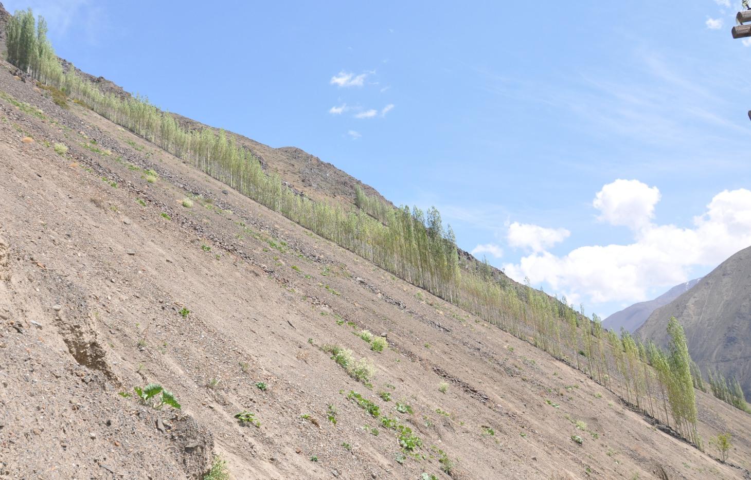
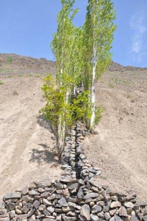
A cascading rock irrigation channel lined with fast growing poplar trees, constructed on rocky slopes to channel water runoff from the high mountains for human use at the valley floor.
2.2 Description détaillée de la Technologie
Description:
A one metre wide, 300m long, irrigation channel constructed of stones, that is built into the steep slope of a mountain gorge. The channel is 0.5m deep and is lined with poplar trees that help stabilise the structure. The water runs down the channel from the top mountains, with water splashing onto the poplar trees. At the foot of the channel the water is used to irrigated cultivated land and provide drinking water.
Purpose of the Technology: The main purpose of the cascading rock irrigation structure is to capture surface water run-off from the top of the mountain and channel it to where it can be utilised for human use such as drinking water, sanitation, and irrigation. The uneven surface of the rock channel slows the pace of the water thus preventing scouring at the foot of the channel. The channel also provides a suitable environment for the cultivation of poplar trees which in turn can help reduce water and wind erosion on the slopes, thus preventing rock and debris movement down onto the cultivated lands on the valley floor.
Establishment / maintenance activities and inputs: The channel is dug perpendicular to the steep slope and lined with stones gathered from the mountainous slopes. This activity is labour intensive, but can be more efficient with the use of donkeys. The stones are placed upon/on top of each other in the base of the channel, and used to line the sides of the channel to retain the water. The soil along the edge of the channel is cleared of debris and stone until it is suitable for the planting of poplar cuttings. The cutting are supplemented with organic fertiliser. The channel is financed by the land owner, with voluntary support from the community.
Natural / human environment: The cascading rock irrigation channel is located in a remote steep mountainous gorge where there is a shortage of land for cultivation. Water is in short supply, especially during the hot summer months. Subsequently the inhabitants have a high dependency on irrigated water from the top of the mountain range. The majority of the residents have a semi-subsistence living and are highly reliant upon the cultivated land where they grow a range of crops (e.g. wheat, potatoes. etc), fruits (e.g. apricots) and poplar trees for selling and construction purposes.
2.3 Photos de la Technologie
Galerie Médias
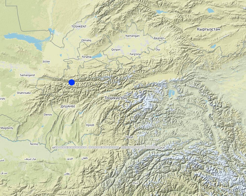
2.5 Pays/ région/ lieux où la Technologie a été appliquée et qui sont couverts par cette évaluation
Pays:
Tadjikistan
Région/ Etat/ Province:
Sogd region
Autres spécifications du lieu:
Ayni
Spécifiez la diffusion de la Technologie:
- répartie uniformément sur une zone
S'il n'existe pas d'informations exactes sur la superficie, indiquez les limites approximatives de la zone couverte:
- < 0,1 km2 (10 ha)
Commentaires:
Long and narrow geographical areas were chosen for implementation of the technology. The technology was replicated ten times in this community area.
Map
×2.6 Date de mise en œuvre de la Technologie
Si l'année précise est inconnue, indiquez la date approximative: :
- il y a entre 10-50 ans
2.7 Introduction de la Technologie
Spécifiez comment la Technologie a été introduite: :
- grâce à l'innovation d'exploitants des terres
Commentaires (type de projet, etc.) :
The technology was constructed in 1992 and 1997 based upon ideas generated from the local inhabitants.
3. Classification de la Technologie de GDT
3.1 Principal(aux) objectif(s) de la Technologie
- réduire, prévenir, restaurer les terres dégradées
- improved access to water
3.2 Type(s) actuel(s) d'utilisation des terres, là où la Technologie est appliquée

Terres cultivées
- Cultures annuelles
- Plantations d’arbres ou de buissons
Cultures annuelles - Précisez les cultures:
- céréales - blé d'hiver
- plantes à racines et à tubercules - pommes de terre
Plantations d'arbres et d'arbustes - Précisez les cultures:
- fruits à noyaux (pêche, abricot, cerise, prune)
Nombre de période de croissance par an: :
- 1

Forêts/ bois
- Forêts (semi-)naturelles/ bois
- Plantations d'arbres, boisements
Plantation d'arbres, afforestation: Précisez l'origine et la composition des espèces. :
- Variété locale en monoculture
Produits et services:
- Protection contre les aléas naturels
- construction

Autre
Précisez:
Wasteland: The mountain slopes are mainly devoid of vegetation.
Commentaires:
Major land use problems (compiler’s opinion): Water and wind erosion, rockfalls and debris movement.
Major land use problems (land users’ perception): Debris movement due to excessive rains damaging crops and infrastructure.
Selective felling of (semi-) natural forests: Infrequent felling of poplars.
Forest products and services: timber, protection against natural hazards
Other forest products and services: construction
Future (final) land use (after implementation of SLM Technology): Forests / woodlands: Fp: Plantations, afforestations
Constraints of wastelands / deserts / glaciers / swamps
3.3 Est-ce que l’utilisation des terres a changé en raison de la mise en œuvre de la Technologie ?
Terres cultivées
- Cultures annuelles
- Plantations d’arbres ou de buissons
Cultures annuelles - Précisez les cultures:
- céréales - blé de printemps
- plantes à racines et à tubercules - pommes de terre
Plantations d'arbres et d'arbustes - Précisez les cultures:
- fruits à noyaux (pêche, abricot, cerise, prune)
Forêts/ bois
- Plantations d'arbres, boisements
3.4 Approvisionnement en eau
Approvisionnement en eau des terres sur lesquelles est appliquée la Technologie:
- pluvial
Commentaires:
Number of growing seasons per year:
1
Specify:
Longest growing period in days: 180Longest growing period from month to month: March-October
3.5 Groupe de GDT auquel appartient la Technologie
- mesures en travers de la pente
- gestion de l'irrigation (incl. l'approvisionnement en eau, le drainage)
- dérivation et drainage de l'eau
3.6 Mesures de GDT constituant la Technologie

pratiques agronomiques
- A1: Couverture végétale/ du sol

pratiques végétales
- V1: Couverture d’arbres et d’arbustes

structures physiques
- S3: Fossés étagés, canaux, voies d'eau
Commentaires:
Main measures: vegetative measures, structural measures
Type of vegetative measures: aligned: -linear
3.7 Principaux types de dégradation des terres traités par la Technologie

érosion hydrique des sols
- Wg: ravinement/ érosion en ravines
- Wm: mouvements de masse/ glissements de terrain

érosion éolienne des sols
- Ed: déflation et déposition
Commentaires:
Main type of degradation addressed: Wm: mass movements / landslides
Secondary types of degradation addressed: Wg: gully erosion / gullying, Ed: deflation and deposition
Main causes of degradation: deforestation / removal of natural vegetation (incl. forest fires) (Removal of forest vegetation many years before.), Heavy / extreme rainfall (intensity/amounts) (Extreme events lead to debris movement covering fertile lands.)
Secondary causes of degradation: war and conflicts (Lack of natural resources during civil war led to the cutting of many of the trees preventing slope movement.)
3.8 Prévention, réduction de la dégradation ou réhabilitation des terres dégradées
Spécifiez l'objectif de la Technologie au regard de la dégradation des terres:
- réduire la dégradation des terres
4. Spécifications techniques, activités, intrants et coûts de mise en œuvre
4.1 Dessin technique de la Technologie
Spécifications techniques (associées au dessin technique):
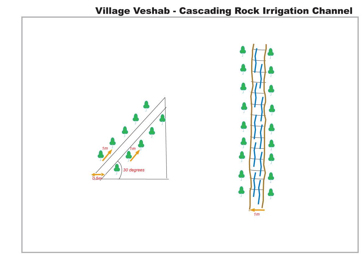
The drawing shows in plan and profile the cascading rock channel. The slope of the mountain is 30 degrees, a one metre wide channel, 0.5 m deep, is dug into the slope. The channel is lined with stones. The soil either side of the channel is cleared of rocks, and poplar branches are planted at 1m intervals lining the channel.
Location: Veshab Boloi Dasht. Ayni Sughd Region Tajikistan
Date: 2011-05-04
Technical knowledge required for land users: moderate (An understanding of how to build the basic structure without it collapsing and able to meet the discharge capacity of the water.)
Main technical functions: control of concentrated runoff: drain / divert, water harvesting / increase water supply, Prevent off site damage to cultivated land at the foot of the slope.
Secondary technical functions: Stabilisation of soil along the channel.
Aligned: -linear
Vegetative material: T : trees / shrubs
Number of plants per (ha): 600
Vertical interval within rows / strips / blocks (m): 1
Width within rows / strips / blocks (m): 1
Trees/ shrubs species: Poplars (safedor) are planted in vertical rows, 1m apart, on both sides of the 1m wide channel.
Slope (which determines the spacing indicated above): 30.00%
Waterway
Depth of ditches/pits/dams (m): 0.5
Width of ditches/pits/dams (m): 1
Length of ditches/pits/dams (m): 300
Construction material (stone): local stones and rocks
Slope (which determines the spacing indicated above): 30%
Vegetation is used for stabilisation of structures.
Auteur:
Davlatov Davlatbek, Dushanbe City,Rudaki str.131,fl.19
4.2 Informations générales sur le calcul des intrants et des coûts
Spécifiez la manière dont les coûts et les intrants ont été calculés:
- par entité de la Technologie
autre/ monnaie nationale (précisez):
Somoni
Indiquez le taux de change des USD en devise locale, le cas échéant (p.ex. 1 USD = 79.9 réal brésilien): 1 USD = :
4,5
Indiquez le coût salarial moyen de la main d'œuvre par jour:
5.50
4.3 Activités de mise en place/ d'établissement
| Activité | Calendrier des activités (saisonnier) | |
|---|---|---|
| 1. | Planting Poplars | Spring, March |
| 2. | Composting | spring |
| 3. | Construction of rock irrigation channel | spring |
4.4 Coûts et intrants nécessaires à la mise en place
| Spécifiez les intrants | Unité | Quantité | Coûts par unité | Coût total par intrant | % du coût supporté par les exploitants des terres | |
|---|---|---|---|---|---|---|
| Main d'œuvre | Planting Poplars | Persons/day | 10,0 | 25,0 | 250,0 | 100,0 |
| Main d'œuvre | Construction of rock irrigation channel | Persons/day | 60,0 | 25,0 | 1500,0 | 100,0 |
| Equipements | Tools | Pieces | 3,0 | 20,0 | 60,0 | 100,0 |
| Equipements | Donkey | Donkey/day | 20,0 | 22,5 | 450,0 | 100,0 |
| Matériel végétal | Seedlings | Unit | 1,0 | 266,0 | 266,0 | 100,0 |
| Engrais et biocides | Composte | per tree | 250,0 | 1,0 | 250,0 | 100,0 |
| Matériaux de construction | Stone | tons | 50,0 | 20,0 | 1000,0 | 100,0 |
| Coût total de mise en place de la Technologie | 3776,0 | |||||
| Coût total de mise en place de la Technologie en dollars américains (USD) | 839,11 | |||||
Commentaires:
Duration of establishment phase: 1 month(s)
4.5 Activités d'entretien/ récurrentes
| Activité | Calendrier/ fréquence | |
|---|---|---|
| 1. | tree tending | every year |
| 2. | Maintenance of channel | Spring |
4.6 Coûts et intrants nécessaires aux activités d'entretien/ récurrentes (par an)
| Spécifiez les intrants | Unité | Quantité | Coûts par unité | Coût total par intrant | % du coût supporté par les exploitants des terres | |
|---|---|---|---|---|---|---|
| Main d'œuvre | Tree tending | Persons/day | 7,0 | 25,0 | 175,0 | 100,0 |
| Main d'œuvre | Maintenance of channel | Persons/day | 10,0 | 25,0 | 250,0 | 100,0 |
| Coût total d'entretien de la Technologie | 425,0 | |||||
| Coût total d'entretien de la Technologie en dollars américains (USD) | 94,44 | |||||
Commentaires:
The indicative cost of the technology was calculated based on 2010 prices.
4.7 Facteurs les plus importants affectant les coûts
Décrivez les facteurs les plus importants affectant les coûts :
There was no real cost in construction of the rock irrigation channel. All labour, animal traction and materials were sourced locally for no cost, poplar seedlings are cuttings from local poplars, and organic compost for the trees was collected from local livestock.
5. Environnement naturel et humain
5.1 Climat
Précipitations annuelles
- < 250 mm
- 251-500 mm
- 501-750 mm
- 751-1000 mm
- 1001-1500 mm
- 1501-2000 mm
- 2001-3000 mm
- 3001-4000 mm
- > 4000 mm
Spécifications/ commentaires sur les précipitations:
Heavy Spring and Autumn Rain
Zone agro-climatique
- semi-aride
Thermal climate class: temperate. 4 months of snowing during the winter period.
5.2 Topographie
Pentes moyennes:
- plat (0-2 %)
- faible (3-5%)
- modéré (6-10%)
- onduleux (11-15%)
- vallonné (16-30%)
- raide (31-60%)
- très raide (>60%)
Reliefs:
- plateaux/ plaines
- crêtes
- flancs/ pentes de montagne
- flancs/ pentes de colline
- piémonts/ glacis (bas de pente)
- fonds de vallée/bas-fonds
Zones altitudinales:
- 0-100 m
- 101-500 m
- 501-1000 m
- 1001-1500 m
- 1501-2000 m
- 2001-2500 m
- 2501-3000 m
- 3001-4000 m
- > 4000 m
Commentaires et précisions supplémentaires sur la topographie:
Altitudinal zone: This area is located at 1500m
5.3 Sols
Profondeur moyenne du sol:
- très superficiel (0-20 cm)
- superficiel (21-50 cm)
- modérément profond (51-80 cm)
- profond (81-120 cm)
- très profond (>120 cm)
Texture du sol (de la couche arable):
- grossier/ léger (sablonneux)
Matière organique de la couche arable:
- faible (<1%)
Si disponible, joignez une description complète du sol ou précisez les informations disponibles, par ex., type de sol, pH/ acidité du sol, capacité d'échange cationique, azote, salinité, etc.
Soil texture is rocky, shale.
Soil fertility is very low and nothing is growing on the adjacent slopes.
Soil drainage / infiltration is poor
Soil water storage capacity is very low.
5.4 Disponibilité et qualité de l'eau
Profondeur estimée de l’eau dans le sol:
> 50 m
Disponibilité de l’eau de surface:
faible/ absente
Qualité de l’eau (non traitée):
eau potable
5.5 Biodiversité
Diversité des espèces:
- faible
Commentaires et précisions supplémentaires sur la biodiversité:
No natural propogation/reproduction on the slope and slow growth rate without irrigation.
5.6 Caractéristiques des exploitants des terres appliquant la Technologie
Orientation du système de production:
- subsistance (auto-approvisionnement)
- exploitation mixte (de subsistance/ commerciale)
Revenus hors exploitation:
- > 50% de tous les revenus
Niveau relatif de richesse:
- moyen
Individus ou groupes:
- groupe/ communauté
Genre:
- femmes
- hommes
Indiquez toute autre caractéristique pertinente des exploitants des terres:
Land users applying the Technology are mainly common / average land users
Population density: < 10 persons/km2
Annual population growth: 1% - 2%
100% of the land users are average wealthy and own 100% of the land.
Off-farm income specification: Some of the incomes come from driving, teaching etc
Market orientation of production system: Poplars are used for personal construction projects but can be sold for $300 per tree.
5.7 Superficie moyenne des terres utilisées par les exploitants des terres appliquant la Technologie
- < 0,5 ha
- 0,5-1 ha
- 1-2 ha
- 2-5 ha
- 5-15 ha
- 15-50 ha
- 50-100 ha
- 100-500 ha
- 500-1 000 ha
- 1 000-10 000 ha
- > 10 000 ha
Cette superficie est-elle considérée comme de petite, moyenne ou grande dimension (en se référant au contexte local)?
- petite dimension
5.8 Propriété foncière, droits d’utilisation des terres et de l'eau
Propriété foncière:
- état
Droits d’utilisation des terres:
- communautaire (organisé)
Droits d’utilisation de l’eau:
- communautaire (organisé)
5.9 Accès aux services et aux infrastructures
santé:
- pauvre
- modéré
- bonne
éducation:
- pauvre
- modéré
- bonne
assistance technique:
- pauvre
- modéré
- bonne
emploi (par ex. hors exploitation):
- pauvre
- modéré
- bonne
marchés:
- pauvre
- modéré
- bonne
énergie:
- pauvre
- modéré
- bonne
routes et transports:
- pauvre
- modéré
- bonne
eau potable et assainissement:
- pauvre
- modéré
- bonne
services financiers:
- pauvre
- modéré
- bonne
6. Impacts et conclusions
6.1 Impacts sur site que la Technologie a montrés
Impacts socio-économiques
Production
production de bois
surface de production
Disponibilité et qualité de l'eau
disponibilité de l'eau potable
disponibilité de l'eau pour l'élevage
Revenus et coûts
revenus agricoles
Impacts socioculturels
sécurité alimentaire/ autosuffisance
connaissances sur la GDT/ dégradation des terres
Livelihood and human well-being
Commentaires/ spécifiez:
This includes wood for construction, improved water supply for irrigation and improved water quality for drinking and sanitation.
Impacts écologiques
Cycle de l'eau/ ruissellement
quantité d'eau
qualité de l'eau
récolte/ collecte de l'eau
ruissellement de surface
Sols
perte en sol
Réduction des risques de catastrophe et des risques climatiques
glissements de terrains/coulées de débris
vitesse du vent
6.2 Impacts hors site que la Technologie a montrés
disponibilité de l'eau
sédiments (indésirables) transportés par le vent
dommages sur les champs voisins
dommages sur les infrastructures publiques/ privées
6.3 Exposition et sensibilité de la Technologie aux changements progressifs et aux évènements extrêmes/catastrophes liés au climat (telles que perçues par les exploitants des terres)
Changements climatiques progressifs
Changements climatiques progressifs
| Saison | Augmentation ou diminution | Comment la Technologie fait-elle face à cela? | |
|---|---|---|---|
| températures annuelles | augmente | bien |
Extrêmes climatiques (catastrophes)
Catastrophes météorologiques
| Comment la Technologie fait-elle face à cela? | |
|---|---|
| pluie torrentielle locale | bien |
| tempête de vent locale | bien |
Catastrophes climatiques
| Comment la Technologie fait-elle face à cela? | |
|---|---|
| sécheresse | pas bien |
Catastrophes hydrologiques
| Comment la Technologie fait-elle face à cela? | |
|---|---|
| inondation générale (rivière) | pas bien |
Autres conséquences liées au climat
Autres conséquences liées au climat
| Comment la Technologie fait-elle face à cela? | |
|---|---|
| mass soil movement | pas bien |
6.4 Analyse coûts-bénéfices
Quels sont les bénéfices comparativement aux coûts de mise en place (du point de vue des exploitants des terres)?
Rentabilité à court terme:
très positive
Rentabilité à long terme:
très positive
Quels sont les bénéfices comparativement aux coûts d'entretien récurrents (du point de vue des exploitants des terres)?
Rentabilité à court terme:
très positive
Rentabilité à long terme:
très positive
Commentaires:
Low initial expense due to inputs easily available.
6.5 Adoption de la Technologie
- 1-10%
Si disponible, quantifiez (nombre de ménages et/ou superficie couverte):
400 households
De tous ceux qui ont adopté la Technologie, combien d'entre eux l'ont fait spontanément, à savoir sans recevoir aucune incitation matérielle, ou aucune rémunération? :
- 91-100%
Commentaires:
5% of land user families have adopted the Technology without any external material support
400 land user families have adopted the Technology without any external material support
Comments on spontaneous adoption: Minimal replication in small areas of land, but no replication in recent years. (It appears in this area the implementation of the technology may have been optimised).
There is no trend towards spontaneous adoption of the Technology
6.7 Points forts/ avantages/ possibilités de la Technologie
| Points forts/ avantages/ possibilités du point de vue de l'exploitant des terres |
|---|
|
Improved livelihoods and the variety and yield of crops. How can they be sustained / enhanced? If the water was not available through the channel then the land would have to be abandoned. |
| The poplar trees provide a good source of secondary income. |
| Points forts/ avantages/ possibilités du point de vue du compilateur ou d'une autre personne ressource clé |
|---|
|
It reduces soil and wind erosion from the mountain slopes. How can they be sustained / enhanced? Further planting of trees. |
| It reduces rockfalls and debris movement, thus protecting the land down slope that is used for cultivation. |
|
It provides water for irrigation and hence leads to an increase in crops yields and crop diversification down slope of the channel. These crops include wheat, potatoes, onions and some fruit trees mainly apricot. How can they be sustained / enhanced? Pipes form the channel to other areas. |
|
Increased access to clean running water has improved sanitation and hygiene conditions for the inhabitants. How can they be sustained / enhanced? Further training on hygiene and sanitation. |
| The use of uneven rocks slows down the speed of the water in the channel and prevents water erosion at the base of the slope. |
6.8 Faiblesses/ inconvénients/ risques de la Technologie et moyens de les surmonter
| Faiblesses/ inconvénients/ risques du point de vue de l’exploitant des terres | Comment peuvent-ils être surmontés? |
|---|---|
| The channel can become severely damaged after a harsh winter. | The rock lining could be cemented in but that would increase the cost, and the trees would not be able to use the water that soaks through the channel. |
| Faiblesses/ inconvénients/ risques du point de vue du compilateur ou d'une autre personne ressource clé | Comment peuvent-ils être surmontés? |
|---|---|
| The technology is a major construction activity that needs to be strategically positioned. | The location should be carefully considered with help of specialists. |
7. Références et liens
7.1 Méthodes/ sources d'information
Liens et modules
Développer tout Réduire toutLiens
Aucun lien
Modules
Aucun module trouvé