Controlled grazing in deciduous woods as an alternative to grazing on rangeland [Italy]
- Creation:
- Update:
- Compiler: Lorenzo Borselli
- Editor: –
- Reviewers: Deborah Niggli, Alexandra Gavilano
Pascolo controllato
technologies_1463 - Italy
- Full summary as PDF
- Full summary as PDF for print
- Full summary in the browser
- Full summary (unformatted)
- Controlled grazing in deciduous woods as an alternative to grazing on rangeland: March 20, 2017 (inactive)
- Controlled grazing in deciduous woods as an alternative to grazing on rangeland: April 4, 2018 (inactive)
- Controlled grazing in deciduous woods as an alternative to grazing on rangeland: April 17, 2019 (public)
View sections
Expand all Collapse all1. General information
1.2 Contact details of resource persons and institutions involved in the assessment and documentation of the Technology
Name of project which facilitated the documentation/ evaluation of the Technology (if relevant)
DESIRE (EU-DES!RE)Name of the institution(s) which facilitated the documentation/ evaluation of the Technology (if relevant)
Universidad Autonoma de San Luis Potosi (Universidad Autonoma de San Luis Potosi) - MexicoName of the institution(s) which facilitated the documentation/ evaluation of the Technology (if relevant)
Consiglio Nazionale delle Ricerche (CNR) - Italy1.3 Conditions regarding the use of data documented through WOCAT
The compiler and key resource person(s) accept the conditions regarding the use of data documented through WOCAT:
Yes
2. Description of the SLM Technology
2.1 Short description of the Technology
Definition of the Technology:
Controlled grazing in deciduous woods seasonally limited in summer when grass cover in rangeland suffers water stress.
2.2 Detailed description of the Technology
Description:
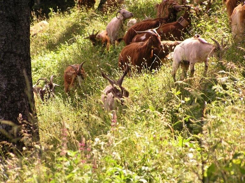
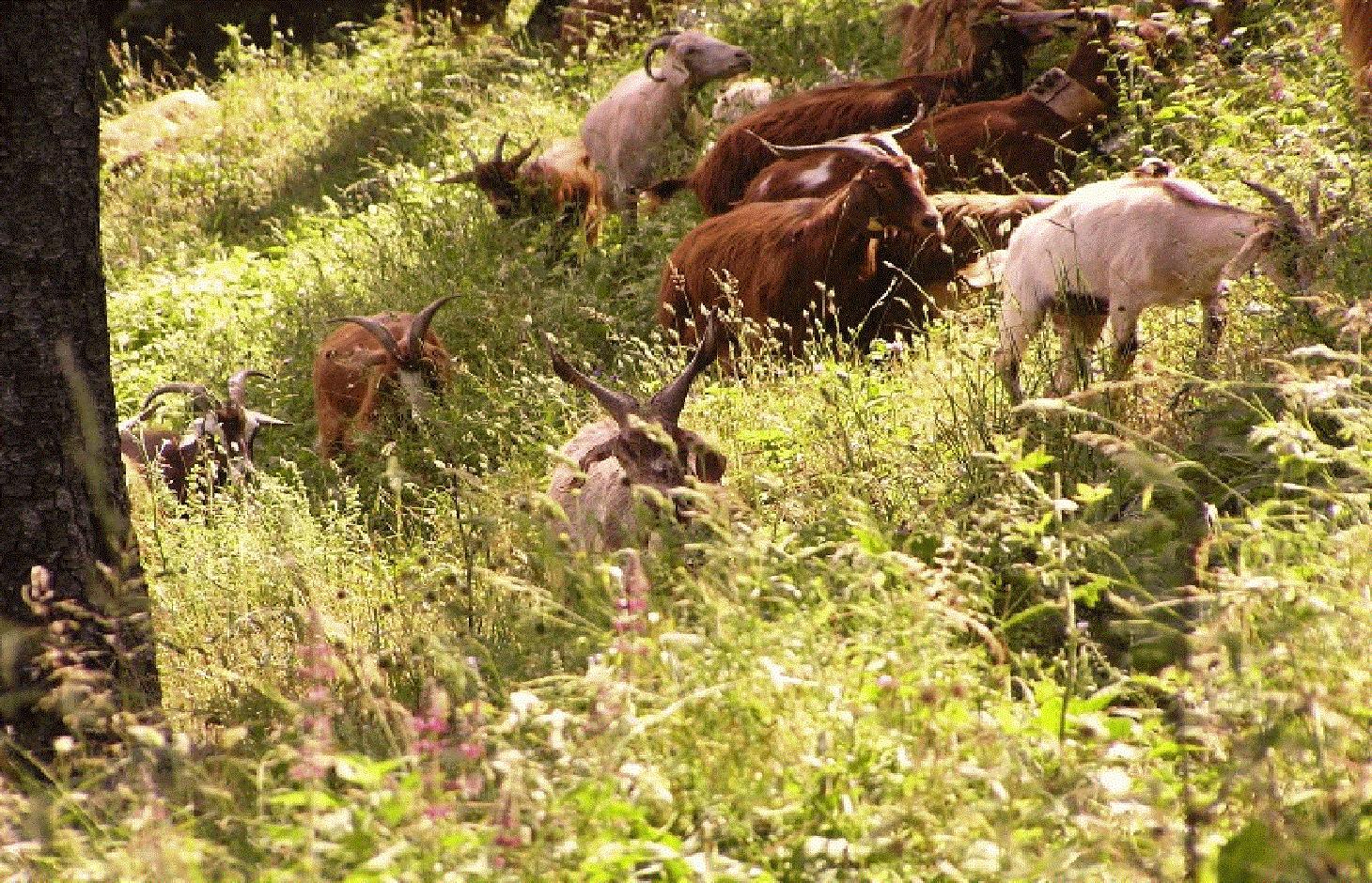
During the driest season, farmers shifts grazing to deciduous forest. Grazing in forest is controlled because it is limited to specific areas and with a controlled number of animals (cows and goats). In deciduous forest, the animals can still find green grass in the dry season. This action prevents excessive stress in the surrounding rangelands, which are suffering from a seasonal summer water deficit, as is typical of areas with a Mediterranean climate.
Purpose of the Technology: One purpose of this management technology is to allow grazing in environments that still preserve grasses in the summer dry season. Moreover, this technology can prevent overgrazing (and its consequences in rangeland and pastures). Controlled grazing is typical in the Rendina watershed (Basilicata, Italy).
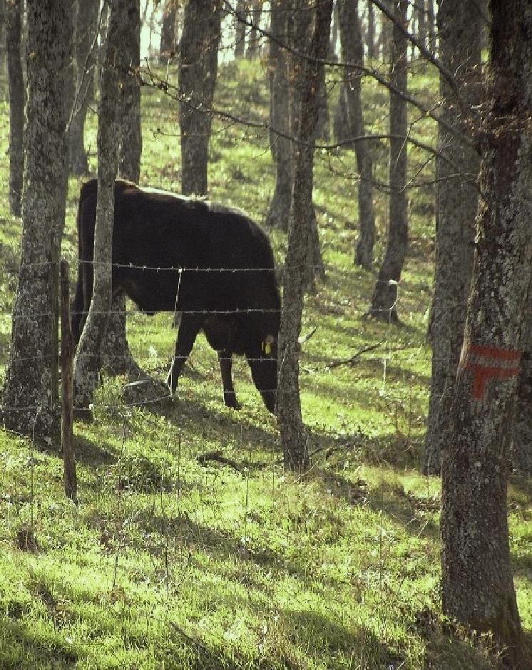
Establishment / maintenance activities and inputs: The upper part of the watershed is located above 800 m a.s.l. and is characterized by deciduous oak forest, which every 20 years is subject to selective cutting. Selective cutting involves cutting a high percentage of a limited range of tree species. Within about 10 years, regeneration of the whole wooded area is possible. This allows for a constant regeneration of the woodland and reduces the probability of a progressive degradation as well as of wildfires due to an excessive build-up of the fuel load. The surrounding areas are either cultivated or rangeland and suffer from the soil erosion and landslides that give rise to degradation and hence to the loss of arable lands.
Natural / human environment: Forests are either government-owned or privately-owned, but controlled grazing woodland areas are mostly government-owned. Based on the number of grazing animals admitted, the farmers need to pay a tax to the municipalities or regions. Each farmer has a specific number of animals admitted to the woodland area and there is a overall maximum of animals especially during summer, when a risk of overgrazing exists. Access to private forest, on the other hand, is arranged directly with the owners.
Grazing is organized on a daily basis by the herdsman. The controlled grazing areas are always located in the woodlands where selective cutting is carried out. In such areas livestock during summer can enter and move more easily in the relatively cool conditions.
When controlled grazing is adopted as the conventional management technology, selective cutting of trees every 20 years is also used to provide additional earnings from the sale of firewood.
Annual rainfall is 500 mm with two rainy seasons (October-November and March-May). Potential evapotranspiration is up to 1100 mm annually. The Rendina catchment ranges from humid-subhumid to subhumid-semiarid conditions. The surrounding area ranges from (subhumid)-semiarid to semiarid-arid.
2.3 Photos of the Technology
Media Gallery
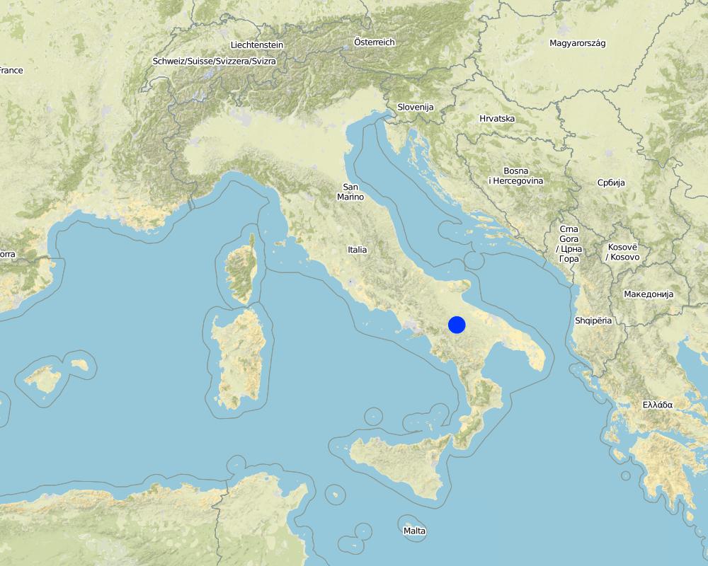
2.5 Country/ region/ locations where the Technology has been applied and which are covered by this assessment
Country:
Italy
Region/ State/ Province:
Potenza / regione basilicata
Further specification of location:
Rendina Basin
Comments:
Total area covered by the SLM Technology is 10 km2.
Renina Watershed - above 800 m a.s.l.
Map
×2.6 Date of implementation
If precise year is not known, indicate approximate date:
- 10-50 years ago
2.7 Introduction of the Technology
Specify how the Technology was introduced:
- through land users' innovation
3. Classification of the SLM Technology
3.1 Main purpose(s) of the Technology
- reduce, prevent, restore land degradation
- conserve ecosystem
3.2 Current land use type(s) where the Technology is applied
Land use mixed within the same land unit:
Yes
Specify mixed land use (crops/ grazing/ trees):
- Silvo-pastoralism

Grazing land
Animal type:
- goats
- cows

Forest/ woodlands
- (Semi-)natural forests/ woodlands
(Semi-)natural forests/ woodlands: Specify management type:
- Selective felling
Products and services:
- Grazing/ browsing
Comments:
Major land use problems (compiler’s opinion): The land users claim about reduction of vegetation cover.
Major land use problems (land users’ perception): This impacts water and tillage erosion and landslides but is not considered as main issue by land user, yet.
Future (final) land use (after implementation of SLM Technology): Mixed: Ms: Silvo-pastoralism
Number of growing seasons per year: 2
Longest growing period in days: 90 Longest growing period from month to month: Apr - Jun Second longest growing period in days: 30 Second longest growing period from month to month: Oct - Oct
Livestock density: 25-50 LU /km2
3.3 Has land use changed due to the implementation of the Technology?
Has land use changed due to the implementation of the Technology?
- Yes (Please fill out the questions below with regard to the land use before implementation of the Technology)
Land use mixed within the same land unit:
No
Forest/ woodlands
- (Semi-)natural forests/ woodlands
3.4 Water supply
Water supply for the land on which the Technology is applied:
- rainfed
3.5 SLM group to which the Technology belongs
- pastoralism and grazing land management
3.6 SLM measures comprising the Technology

management measures
- M7: Others
Comments:
Main measures: management measures
3.7 Main types of land degradation addressed by the Technology

soil erosion by water
- Wt: loss of topsoil/ surface erosion

biological degradation
- Bc: reduction of vegetation cover
- Bq: quantity/ biomass decline
Comments:
Main type of degradation addressed: Bc: reduction of vegetation cover
Secondary types of degradation addressed: Wt: loss of topsoil / surface erosion, Bq: quantity / biomass decline
Main causes of degradation: overgrazing, land tenure
Secondary causes of degradation: droughts
3.8 Prevention, reduction, or restoration of land degradation
Specify the goal of the Technology with regard to land degradation:
- reduce land degradation
4. Technical specifications, implementation activities, inputs, and costs
4.1 Technical drawing of the Technology
Technical specifications (related to technical drawing):
Technical knowledge required for field staff / advisors: moderate
Technical knowledge required for land users: moderate
Main technical functions: improvement of ground cover
Secondary technical functions: stabilisation of soil (eg by tree roots against land slides), increase of biomass (quantity)
Change of land use practices / intensity level
4.2 General information regarding the calculation of inputs and costs
other/ national currency (specify):
euro
If relevant, indicate exchange rate from USD to local currency (e.g. 1 USD = 79.9 Brazilian Real): 1 USD =:
0.8
Indicate average wage cost of hired labour per day:
100.00
4.3 Establishment activities
| Activity | Timing (season) | |
|---|---|---|
| 1. | Selective cutting of woodland |
4.4 Costs and inputs needed for establishment
| Specify input | Unit | Quantity | Costs per Unit | Total costs per input | % of costs borne by land users | |
|---|---|---|---|---|---|---|
| Labour | Selective cutting of woodland | ha | 2.0 | 300.0 | 600.0 | 50.0 |
| Labour | Labour | ha | 1.0 | 100.0 | 100.0 | 100.0 |
| Total costs for establishment of the Technology | 700.0 | |||||
| Total costs for establishment of the Technology in USD | 875.0 | |||||
Comments:
Duration of establishment phase: 1 month(s)
4.5 Maintenance/ recurrent activities
| Activity | Timing/ frequency | |
|---|---|---|
| 1. | Selective cutting of woodland every 20 years | |
| 2. | Shifting animals in closed woodland areas |
4.6 Costs and inputs needed for maintenance/ recurrent activities (per year)
| Specify input | Unit | Quantity | Costs per Unit | Total costs per input | % of costs borne by land users | |
|---|---|---|---|---|---|---|
| Labour | Selective cutting of woodland every 20 years | ha | 2.0 | 300.0 | 600.0 | 50.0 |
| Labour | Shifting animals in closed woodland areas | ha | 2.0 | 150.0 | 300.0 | 100.0 |
| Labour | Labour | ha | 1.0 | 75.0 | 75.0 | 100.0 |
| Total costs for maintenance of the Technology | 975.0 | |||||
| Total costs for maintenance of the Technology in USD | 1218.75 | |||||
Comments:
Selective felling only done every 20 years. Hence the costs ae not as high as they might seem.
4.7 Most important factors affecting the costs
Describe the most determinate factors affecting the costs:
Labour costs are the most important determining factor affecting the costs.
5. Natural and human environment
5.1 Climate
Annual rainfall
- < 250 mm
- 251-500 mm
- 501-750 mm
- 751-1,000 mm
- 1,001-1,500 mm
- 1,501-2,000 mm
- 2,001-3,000 mm
- 3,001-4,000 mm
- > 4,000 mm
Specifications/ comments on rainfall:
autumn and spring rain season
Agro-climatic zone
- sub-humid
Thermal climate class: temperate
5.2 Topography
Slopes on average:
- flat (0-2%)
- gentle (3-5%)
- moderate (6-10%)
- rolling (11-15%)
- hilly (16-30%)
- steep (31-60%)
- very steep (>60%)
Landforms:
- plateau/plains
- ridges
- mountain slopes
- hill slopes
- footslopes
- valley floors
Altitudinal zone:
- 0-100 m a.s.l.
- 101-500 m a.s.l.
- 501-1,000 m a.s.l.
- 1,001-1,500 m a.s.l.
- 1,501-2,000 m a.s.l.
- 2,001-2,500 m a.s.l.
- 2,501-3,000 m a.s.l.
- 3,001-4,000 m a.s.l.
- > 4,000 m a.s.l.
5.3 Soils
Soil depth on average:
- very shallow (0-20 cm)
- shallow (21-50 cm)
- moderately deep (51-80 cm)
- deep (81-120 cm)
- very deep (> 120 cm)
Soil texture (topsoil):
- medium (loamy, silty)
- fine/ heavy (clay)
Topsoil organic matter:
- high (>3%)
If available, attach full soil description or specify the available information, e.g. soil type, soil PH/ acidity, Cation Exchange Capacity, nitrogen, salinity etc.
Soil fertility is: Medium-high
Soil drainage/infiltration is good
Soil water storage capacity is high
5.4 Water availability and quality
Ground water table:
5-50 m
Availability of surface water:
medium
Water quality (untreated):
good drinking water
5.5 Biodiversity
Species diversity:
- medium
5.6 Characteristics of land users applying the Technology
Market orientation of production system:
- mixed (subsistence/ commercial)
- commercial/ market
Off-farm income:
- less than 10% of all income
Relative level of wealth:
- poor
- average
Individuals or groups:
- individual/ household
Gender:
- men
Indicate other relevant characteristics of the land users:
Land users applying the Technology are mainly common / average land users
Population density: 10-50 persons/km2
Annual population growth: < 0.5%
10% of the land users are rich.
60% of the land users are average wealthy and own 80% of the land.
30% of the land users are poor.
5.7 Average area of land used by land users applying the Technology
- < 0.5 ha
- 0.5-1 ha
- 1-2 ha
- 2-5 ha
- 5-15 ha
- 15-50 ha
- 50-100 ha
- 100-500 ha
- 500-1,000 ha
- 1,000-10,000 ha
- > 10,000 ha
Is this considered small-, medium- or large-scale (referring to local context)?
- medium-scale
Comments:
Average area of land owned or leased by land users applying the Technology: Also 5-15 ha, 15-50 ha
5.8 Land ownership, land use rights, and water use rights
Land ownership:
- individual, not titled
Land use rights:
- leased
- individual
Water use rights:
- open access (unorganized)
- individual
5.9 Access to services and infrastructure
health:
- poor
- moderate
- good
education:
- poor
- moderate
- good
technical assistance:
- poor
- moderate
- good
employment (e.g. off-farm):
- poor
- moderate
- good
markets:
- poor
- moderate
- good
energy:
- poor
- moderate
- good
roads and transport:
- poor
- moderate
- good
drinking water and sanitation:
- poor
- moderate
- good
financial services:
- poor
- moderate
- good
6. Impacts and concluding statements
6.1 On-site impacts the Technology has shown
Socio-economic impacts
Production
crop production
animal production
risk of production failure
energy generation
Comments/ specify:
Forest wood
Socio-cultural impacts
SLM/ land degradation knowledge
Improved livelihoods and human well-being
Comments/ specify:
The technology can contribute to education of young farmers.
Ecological impacts
Soil
soil cover
soil loss
Biodiversity: vegetation, animals
biomass/ above ground C
Other ecological impacts
Risk of overgrazing in the woodland
Comments/ specify:
Only if grazing is not well controlled
6.2 Off-site impacts the Technology has shown
downstream flooding
downstream siltation
damage on public/ private infrastructure
6.3 Exposure and sensitivity of the Technology to gradual climate change and climate-related extremes/ disasters (as perceived by land users)
Gradual climate change
Gradual climate change
| Season | increase or decrease | How does the Technology cope with it? | |
|---|---|---|---|
| annual temperature | increase | well |
Other climate-related consequences
Other climate-related consequences
| How does the Technology cope with it? | |
|---|---|
| reduced growing period | not well |
Comments:
increase the number or the extension of the areas within the basin where controlled grazing can be established and performed.
6.4 Cost-benefit analysis
How do the benefits compare with the establishment costs (from land users’ perspective)?
Short-term returns:
slightly positive
Long-term returns:
positive
How do the benefits compare with the maintenance/ recurrent costs (from land users' perspective)?
Short-term returns:
positive
Long-term returns:
positive
Comments:
It is very cheap to maintain the measure. In the surrounding areas, where land should be less degraded due to reduced grazing, more trees can be planted and allowed to grow in future.
6.5 Adoption of the Technology
If available, quantify (no. of households and/ or area covered):
20
Of all those who have adopted the Technology, how many did so spontaneously, i.e. without receiving any material incentives/ payments?
- 51-90%
Comments:
50% of land user families have adopted the Technology with external material support
10 land user families have adopted the Technology with external material support
50% of land user families have adopted the Technology without any external material support
10 land user families have adopted the Technology without any external material support
There is no trend towards spontaneous adoption of the Technology
6.7 Strengths/ advantages/ opportunities of the Technology
| Strengths/ advantages/ opportunities in the land user’s view |
|---|
|
good animal production How can they be sustained / enhanced? the general quality of the products of the grazing (milk, beef and cheese) is improved due to the availability of more grass and water in the driest periods of the year. |
| Strengths/ advantages/ opportunities in the compiler’s or other key resource person’s view |
|---|
|
good impact with low cost How can they be sustained / enhanced? facilitate access to public forest land |
6.8 Weaknesses/ disadvantages/ risks of the Technology and ways of overcoming them
| Weaknesses/ disadvantages/ risks in the land user’s view | How can they be overcome? |
|---|---|
| risk of overgrazing of the woodland area, if the area is not well controlled | ensure control mechanisms |
| rights of access to public lands and forest management rules | the regional legislative process should define better the management of the access of farmers to public lands and in general the whole controlled grazing process. |
| Weaknesses/ disadvantages/ risks in the compiler’s or other key resource person’s view | How can they be overcome? |
|---|---|
| limited wooded areas available for public access | creation of managed enlosures in order to increase natural reforestation or afforestation. |
7. References and links
7.1 Methods/ sources of information
7.2 References to available publications
Title, author, year, ISBN:
Official Bulletin of the Basilicata region (Italy): N. 29 – 29/04/2002; N. 22 – 16/06/2008.Cocca C. & Campanile G. (2005). Pascolo in bosco solo se controllato. Agrifoglio, N. 7, pages 20-21.
Links and modules
Expand all Collapse allLinks
No links
Modules
No modules