Fish ponds for fish production and improved household income [Uganda]
- Creation:
- Update:
- Compiler: Kamugisha Rick Nelson
- Editors: JOY TUKAHIRWA, Sunday Balla Amale, Bernard Fungo
- Reviewers: John Stephen Tenywa, Nicole Harari, Udo Höggel
Dam Reki - Luo - Uganda
technologies_2140 - Uganda
View sections
Expand all Collapse all1. General information
1.2 Contact details of resource persons and institutions involved in the assessment and documentation of the Technology
Key resource person(s)
land user:
Uhuru Santo
+256-772-638166 / +256-0703-638166
rkamu2016@gmail.com / rkamu2012@yahoo.com
Romo Village, Achoyo Parish, Kolo Sub-county, Omoro District
Uganda
Name of project which facilitated the documentation/ evaluation of the Technology (if relevant)
Scaling-up SLM practices by smallholder farmers (IFAD)Name of the institution(s) which facilitated the documentation/ evaluation of the Technology (if relevant)
Uganda Landcare Network (ULN) - Uganda1.3 Conditions regarding the use of data documented through WOCAT
When were the data compiled (in the field)?
28/04/2017
The compiler and key resource person(s) accept the conditions regarding the use of data documented through WOCAT:
Yes
1.4 Declaration on sustainability of the described Technology
Is the Technology described here problematic with regard to land degradation, so that it cannot be declared a sustainable land management technology?
No
2. Description of the SLM Technology
2.1 Short description of the Technology
Definition of the Technology:
Fish ponds are established where there is access to water to enhance fish production and household incomes
2.2 Detailed description of the Technology
Description:
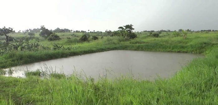
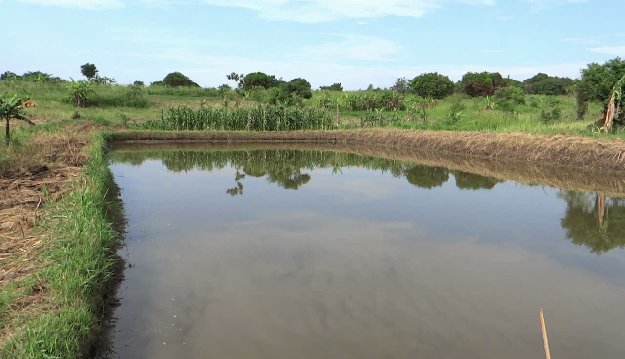
Fish ponds are a common feature in Northern Uganda specifically constructed to raise fish for home consumption and sale to supplement household incomes. Often they are situated on gentle slopes (3-5%) and in wetlands protected with natural vegetation on the levees to act as stabilizers. They are usually recharged from a natural spring.
Establishment of a fish pond requires initial consultation with the extension agents or experts to access knowledge, skills on establishment as well as proper procedures including testing water suitability, presence of reliable water to constantly provide water to the pond, labour, hoes, wheel barrows, spades and slashers.
Establishment activities for the fish pond requires at least 3-5 persons for a period of 5 days per week for the following activities: (i) contacting experts or extension agents for guidance (ii) identifying of suitable land for fish pond establishment (iii) training on digging fish ponds (iv) purchasing equipment required (v) hiring labour and negotiating the payment (vi) excavating the pond and, (vii) identifying the right species of the fish and stocking the fish.
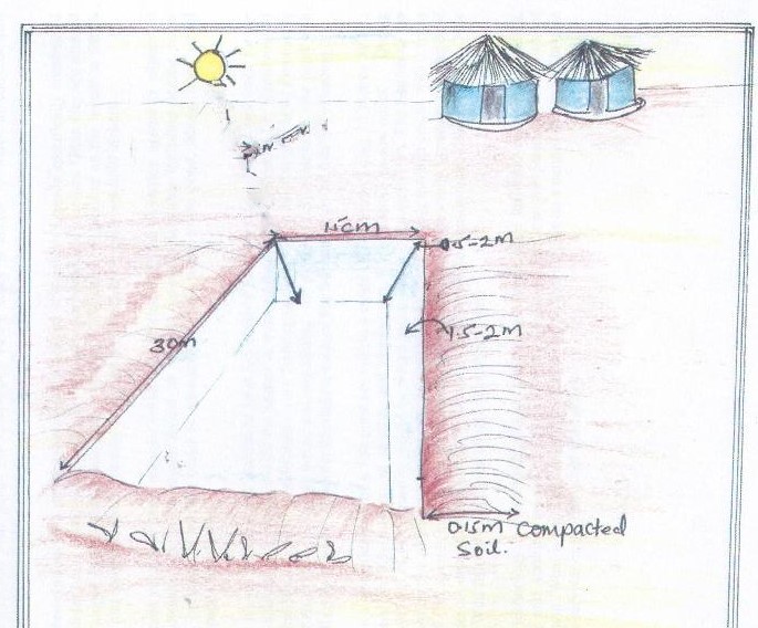
The technical specifications of a fish pond are 30 metres long and 15 metres wide. The depth should be 0.5-1metres at the shallow end and 1.5 -2 metres depth at the pond's outlet. During construction, the soil at the bottom of the planned pond needs to be well compacted. The bottom of the pond should be free of stumps or debris so to avoid leakage through cracks. The banks of the pond consists of compacted earthen rims of approx. 0.15m height and the 0.20 m width.
There shoud be 2 types or more of fish species kept in the fish pond. Sunlight can generally penetrate the pond waters to a depth of about 30-80 cm depending on the water level. The fish species mostly kept include Tilapia, Nile Perch and wild fish.
Once the technology is established the pond system requires only maintenance costs for removing weeds, feeding, restocking and slashing around the pond.
What is not liked about this technology is that it relies on a natural spring. In case of drought survival of the fish is not guaranteed.
2.3 Photos of the Technology
Media Gallery
2.4 Videos of the Technology
Comments, short description:
Fish pond owned by Uhuru Santo in Omolo District, Northern Uganda.
Date:
28/04/2017
Location:
Omolo District, Northern Uganda
Name of videographer:
Issa Aiga
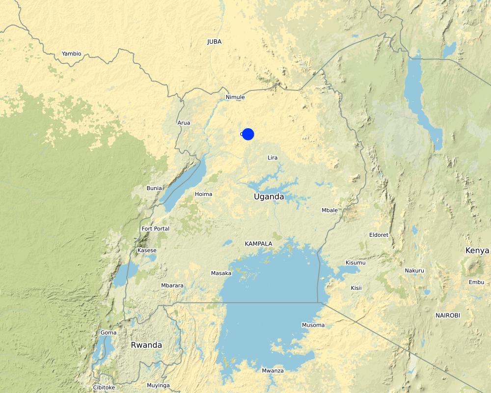
2.5 Country/ region/ locations where the Technology has been applied and which are covered by this assessment
Country:
Uganda
Region/ State/ Province:
Northern Region,Uganda
Further specification of location:
Omolo District
Comments:
Map showing fish pond technology site in Northern Uganda
Map
×2.6 Date of implementation
Indicate year of implementation:
2007
2.7 Introduction of the Technology
Specify how the Technology was introduced:
- through land users' innovation
- through projects/ external interventions
Comments (type of project, etc.):
The farmer started the innovation using his own initiative but later involved the extension agent to train him on fish pond management
3. Classification of the SLM Technology
3.1 Main purpose(s) of the Technology
- improve production
- create beneficial economic impact
3.2 Current land use type(s) where the Technology is applied

Cropland
- Annual cropping
Main crops (cash and food crops):
Banana

Grazing land
Extensive grazing land:
- Nomadism
Main animal species and products:
Goats, cows, sheep and pigs. Pigs belong to a women association of which the farmer's wife is the chair person.
If land use has changed due to the implementation of the Technology, indicate land use before implementation of the Technology:
Annual cropland: land under temporary/annual crops
3.3 Further information about land use
other (e.g. post-flooding):
- spring water
Number of growing seasons per year:
- 1
Livestock density (if relevant):
Cows=5, Goats=5, Sheep=4. These animals are kept mainly for manure and household income.
3.4 SLM group to which the Technology belongs
- surface water management (spring, river, lakes, sea)
- Aquaculture
3.5 Spread of the Technology
Specify the spread of the Technology:
- applied at specific points/ concentrated on a small area
3.6 SLM measures comprising the Technology

vegetative measures
- V2: Grasses and perennial herbaceous plants

structural measures
- S5: Dams, pans, ponds
3.7 Main types of land degradation addressed by the Technology

water degradation
- Hs: change in quantity of surface water
3.8 Prevention, reduction, or restoration of land degradation
Specify the goal of the Technology with regard to land degradation:
- prevent land degradation
4. Technical specifications, implementation activities, inputs, and costs
4.1 Technical drawing of the Technology
Author:
Kaheru
Date:
28/04/2017
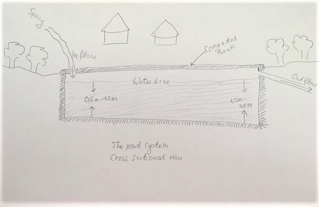
Author:
Prossy Kaheru
Author:
Udo Höggel
4.2 Technical specifications/ explanations of technical drawing
The technical drawing of a fish pond is vertically drawn to show a fish pond in a wetland with natural vegetation allowed to grow to establish the pond. The recommended specifications of a fish pond are within a range of 30 metres x 15 metres. The depth should be 0.5-1metres at the shallow end sloping to 1.5 -2 metres at the outlet. A rim of compacted soil encircles the pond at its banks. The average stocking is 1000-3000 fishes depending critically on the fish species and the size of the fishes, that is its stage of lifecycle.
The second techical drawing shows the structure from a crosssectional view.
4.3 General information regarding the calculation of inputs and costs
Specify how costs and inputs were calculated:
- per Technology area
Indicate size and area unit:
30 metres X 15 metres
other/ national currency (specify):
Uganda Shillings
Indicate exchange rate from USD to local currency (if relevant): 1 USD =:
3400.0
Indicate average wage cost of hired labour per day:
5000
4.4 Establishment activities
| Activity | Type of measure | Timing | |
|---|---|---|---|
| 1. | Identify expert or extension agent to guide | Other measures | Before establishment |
| 2. | Identifying suitable land for fish pond establishment | Other measures | Before establishment and after talking to the expert |
| 3. | Identify location of the fish pond | Other measures | Before establishment / rainy season |
| 4. | Training on how to establish fish pond | Other measures | Before establishment |
| 5. | Buy equipment | Other measures | wet season/before establishment |
| 6. | Look for labour and negotiate costs | Other measures | Before establishment/ dry season |
| 7. | Dig the pond | Structural | At the time of establishment / dry season |
| 8. | Identify the right species and stock | Agronomic | During establishment/ wet season |
| 9. | Feeding | Agronomic | Wet and dry season |
| 10. | Monitoring and routine maintanance | Other measures | During the dry and wet season |
Comments:
Activities geared towards establishing a fish pond where favorable conditions can be sustained
4.5 Costs and inputs needed for establishment
| Specify input | Unit | Quantity | Costs per Unit | Total costs per input | % of costs borne by land users | |
|---|---|---|---|---|---|---|
| Labour | Labour on monthly basis | persons | 5.0 | 150000.0 | 750000.0 | 100.0 |
| Equipment | Spades | Pieces | 5.0 | 10000.0 | 50000.0 | 100.0 |
| Equipment | Slasher | Pieces | 1.0 | 10000.0 | 10000.0 | 100.0 |
| Equipment | Wheel barrow | Pieces | 1.0 | 180000.0 | 180000.0 | 100.0 |
| Other | Fish fry | Pieces | 50.0 | 500.0 | 25000.0 | 100.0 |
| Other | Feeds per week | Kilograms | 5.0 | 10000.0 | 50000.0 | 100.0 |
| Other | Fish nets | Pieces | 7.0 | 50000.0 | 350000.0 | 100.0 |
| Total costs for establishment of the Technology | 1415000.0 | |||||
4.6 Maintenance/ recurrent activities
| Activity | Type of measure | Timing/ frequency | |
|---|---|---|---|
| 1. | Transporting the equipment | Other measures | During the dry season/ on set of rains |
| 2. | Slashing | Management | Wet season |
| 3. | Restocking the fish | Agronomic | wet and dry season |
| 4. | Providing the security of the fish | Other measures | wet and dry season |
| 5. | Feeding | Other measures | wet and dry season |
| 6. | Monitoring the fish | Other measures | wet and dry season |
| 7. | Fishing | Other measures | wet and dry season |
| 8. | Selling | Other measures | wet and dry season |
4.7 Costs and inputs needed for maintenance/ recurrent activities (per year)
| Specify input | Unit | Quantity | Costs per Unit | Total costs per input | % of costs borne by land users | |
|---|---|---|---|---|---|---|
| Labour | Labour on monthly basis | persons | 1.0 | 150000.0 | 150000.0 | 100.0 |
| Total costs for maintenance of the Technology | 150000.0 | |||||
4.8 Most important factors affecting the costs
Describe the most determinate factors affecting the costs:
Labour is the important factor that influences costs. The farmer used own money to hire labour.
5. Natural and human environment
5.1 Climate
Annual rainfall
- < 250 mm
- 251-500 mm
- 501-750 mm
- 751-1,000 mm
- 1,001-1,500 mm
- 1,501-2,000 mm
- 2,001-3,000 mm
- 3,001-4,000 mm
- > 4,000 mm
Specifications/ comments on rainfall:
Two rainy seasons and two dry season
Agro-climatic zone
- humid
5.2 Topography
Slopes on average:
- flat (0-2%)
- gentle (3-5%)
- moderate (6-10%)
- rolling (11-15%)
- hilly (16-30%)
- steep (31-60%)
- very steep (>60%)
Landforms:
- plateau/plains
- ridges
- mountain slopes
- hill slopes
- footslopes
- valley floors
Altitudinal zone:
- 0-100 m a.s.l.
- 101-500 m a.s.l.
- 501-1,000 m a.s.l.
- 1,001-1,500 m a.s.l.
- 1,501-2,000 m a.s.l.
- 2,001-2,500 m a.s.l.
- 2,501-3,000 m a.s.l.
- 3,001-4,000 m a.s.l.
- > 4,000 m a.s.l.
Indicate if the Technology is specifically applied in:
- concave situations
5.3 Soils
Soil depth on average:
- very shallow (0-20 cm)
- shallow (21-50 cm)
- moderately deep (51-80 cm)
- deep (81-120 cm)
- very deep (> 120 cm)
Soil texture (topsoil):
- medium (loamy, silty)
Soil texture (> 20 cm below surface):
- medium (loamy, silty)
Topsoil organic matter:
- high (>3%)
5.4 Water availability and quality
Ground water table:
on surface
Availability of surface water:
excess
Water quality (untreated):
good drinking water
Is water salinity a problem?
No
Is flooding of the area occurring?
No
Comments and further specifications on water quality and quantity:
There is a lot of drought occurring due to deforestation
5.5 Biodiversity
Species diversity:
- medium
Habitat diversity:
- low
5.6 Characteristics of land users applying the Technology
Sedentary or nomadic:
- Sedentary
Market orientation of production system:
- subsistence (self-supply)
- mixed (subsistence/ commercial
Off-farm income:
- 10-50% of all income
Relative level of wealth:
- average
Individuals or groups:
- individual/ household
Level of mechanization:
- manual work
Gender:
- women
- men
Age of land users:
- youth
- middle-aged
5.7 Average area of land owned or leased by land users applying the Technology
- < 0.5 ha
- 0.5-1 ha
- 1-2 ha
- 2-5 ha
- 5-15 ha
- 15-50 ha
- 50-100 ha
- 100-500 ha
- 500-1,000 ha
- 1,000-10,000 ha
- > 10,000 ha
Is this considered small-, medium- or large-scale (referring to local context)?
- medium-scale
Comments:
Inherited land
5.8 Land ownership, land use rights, and water use rights
Land ownership:
- individual, not titled
Land use rights:
- open access (unorganized)
Water use rights:
- open access (unorganized)
- individual
Comments:
Farmer has submitted application to Registrar of Titles for registration of land
5.9 Access to services and infrastructure
health:
- poor
- moderate
- good
education:
- poor
- moderate
- good
technical assistance:
- poor
- moderate
- good
employment (e.g. off-farm):
- poor
- moderate
- good
markets:
- poor
- moderate
- good
energy:
- poor
- moderate
- good
roads and transport:
- poor
- moderate
- good
drinking water and sanitation:
- poor
- moderate
- good
financial services:
- poor
- moderate
- good
6. Impacts and concluding statements
6.1 On-site impacts the Technology has shown
Socio-economic impacts
Production
fodder production
Comments/ specify:
Fodder grasses planted on the pond levee
6.4 Cost-benefit analysis
How do the benefits compare with the establishment costs (from land users’ perspective)?
Short-term returns:
slightly positive
Long-term returns:
positive
How do the benefits compare with the maintenance/ recurrent costs (from land users' perspective)?
Short-term returns:
slightly negative
Long-term returns:
positive
Comments:
High costs at the time of establishment with more benefits and increased income when fish is sold
6.5 Adoption of the Technology
- 1-10%
If available, quantify (no. of households and/ or area covered):
6
Of all those who have adopted the Technology, how many have did so spontaneously, i.e. without receiving any material incentives/ payments?
- 90-100%
6.6 Adaptation
Has the Technology been modified recently to adapt to changing conditions?
Yes
If yes, indicate to which changing conditions it was adapted:
- climatic change/ extremes
Specify adaptation of the Technology (design, material/ species, etc.):
Growing natural vegetation around the pond to act as bank stabilizer and fodder source
6.7 Strengths/ advantages/ opportunities of the Technology
| Strengths/ advantages/ opportunities in the land user’s view |
|---|
| Provides employment to the local communities |
| Easy to maintain with minimum costs |
| Provides income form the sale of the fish |
| Easily replicated |
| Strengths/ advantages/ opportunities in the compiler’s or other key resource person’s view |
|---|
| Does not require high maintenance costs once established |
| Requires technical advice which is available with extension workers |
6.8 Weaknesses/ disadvantages/ risks of the Technology and ways of overcoming them
| Weaknesses/ disadvantages/ risks in the land user’s view | How can they be overcome? |
|---|---|
| Easily affected by drought especially during the dry season | Water harvesting |
| High costs for feeding and paying labour | Use of family / group labour/ growing more vegetation |
| Fish is easily attacked by preditors (crocodiles) which reduces harvest | Kill preditors |
| Weaknesses/ disadvantages/ risks in the compiler’s or other key resource person’s view | How can they be overcome? |
|---|---|
| Not fenced yet poisoning is a common threat | Fencing / employ a guard |
| Requires more capital to establish | Link the farmer to credit institutions and pay after selling fish |
7. References and links
7.1 Methods/ sources of information
- field visits, field surveys
Interviewed the only one respondent who is the resource person
- interviews with land users
Interviewed the only one respondent who is the resource person
Links and modules
Expand all Collapse allLinks
No links
Modules
No modules